* Today: 22nd day in a row with no measurable rain in the Twin Cities (all-time record for dry spells is 51 days in late '43 and early '44).
* October temperatures: more than 7 F. warmer than average in the Twin Cities.
* We have yet to see our first official 32 at MSP. Average date of the first 32 at MSP International: Oct. 7.
* Jacket weather through Tuesday, but we should top 60 Wednesday, again late in the week.
* Computer models hinting at stormier, wetter weather the last week of October, possibly significant rain for Halloween weekend - it may be cold enough for rain to end as a period of wet snow...still way too early for details.
Boat Mania. It was quite a scene out in Winsted yesterday - a major block of historic, old (beautifully restored) boats coming up for auction. The Mecum Auction folks did a great job - they put hundreds of boats, engines, even water skis up for sale. It was a full house, hundreds of boat enthusiasts in attendance. Somehow I left with my wallet largely intact.


If A Rambler Mated With a Chris Craft. This one had everyone doing double-takes.

Speed Racer. It would be fun to zip around on Lake Calhoun or 'Tonka in this thing. All hand-polished wood - I get tired just thinking about what it would take to keep it in this condition...
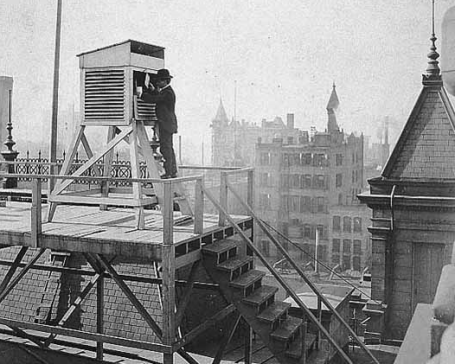
Observing The Weather. The modern-day weather record dates back to 1890, when consistent, detailed observations were first kept in downtown Minneapolis.

October Extremes. Few other states in the USA can boast a 114 F. temperature spread in one month. From a toasty 98 F. at Beardsley to a nippy -16 F in Roseau.
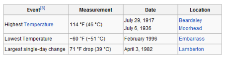
But Wait - There's More! Looking at every month of the year the temperature extremes are even more eye-opening: a 174 F. temperature differential from hottest to coldest! Both Beardsley and Moorhead registered highs of 114 F, poor Embarrass gets the award for the coldest reading, a crisp -60 F. When I say that we have more extreme weather than any other region except possibly Siberia I'm not exaggerating. More on Minnesota's crazy weather extremes and weather records here.
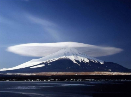
"Cap Cloud." This is a spectacular example of a cap cloud, or "lenticular cloud", a lens-shaped cloud triggered by air flow up and over mountainous regions (in this case over Mt. Fuji, Japan). Sometimes these nearly stationary clouds can linger for hours - often mistaken for UFO's. More on lenticularis (which are quite rare east of the Rockies) here.
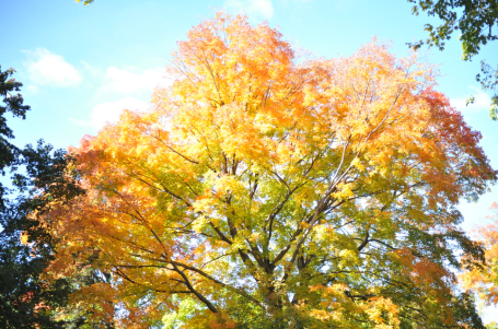
An October To Remember. Do you realize how lucky we've been this month? No rain, no storms, no wild frontal passages - no snow or ice (yet). Most of the Twin Cities metro area hasn't even seen the first 32 F. of the fall season yet - it should have come around October 7. As I mention in today's column, we've essentially enjoyed 2 Septembers in a row. Metro temperatures for the month are running more than 7 F. warmer than average. Another relatively quiet week is on tap - many towns will have gone 4 WEEKS IN A ROW without measurable rain, which is very rare. Models are hinting at a real storm Halloween weekend, probably warm enough for mostly-rain, but a changeover to wet snow can't be ruled out, especially up north. Accumulation? Too early to tell.
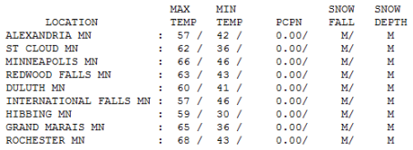
One More Time. Not bad for the third week of October. Blue sky, a fresh breeze, Saturday highs ranged from 57 at Alexandria to 62 at St. Cloud, 66 in the Twin Cities and a very respectable 68 at Rochester.
Paul's Conservation MN Outlook for the Twin Cities and all of Minnesota
Today: Clouds increase - a few light showers/sprinkles south/west of the MN River. Winds: NW 10-20. High: 56
Sunday night: Partly cloudy and cool. Low: 39
Monday: A mix of clouds and sun, feels like mid October again. High: 58
Tuesday: More sun, a bit milder. High: near 60
Wednesday: Plenty of sun, Indian Summer returns! High: 63
Thursday: What else, bright sunshine. High: 57
Friday: Still September-ish. More blue sky, a few degrees warmer. High: near 60
Saturday: Sunshine lingers - still pretty spectacular for late October. High: 62
September (the sequel)
Definition of an optimist? A Minnesotan with a swimming pool or a convertible. Yesterday, wearing a black arm band and a resigned grimace, I put my '85 convertible into cold storage for the winter. Reluctantly. Grudgingly. Yes, we have become hopelessly (ridiculously) spoiled. We're really enjoying two Septembers, back to back. No, this doesn't PROVE climate change, but it is consistent with a slow warming trend that's sparking earlier springs, pushing autumn back 2+ weeks, and (according to Mark Seeley) 4 times more winter rain/ice events in just the last decade.
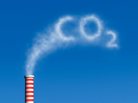
Those crazy radicals at NOAA insist the first 9 months of 2010 were the warmest on record worldwide; land & ocean temperatures tying the previous record, 1998. While we "debate" the science the Chinese are pushing ahead with massive solar & wind power projects, creating hundreds of thousands of new jobs. At this rate the USA may soon lose its competitive edge.
We've gone 3 weeks without measurable rain. A month without rain? That happens once every 4-7 years or so. Rain is possible Oct. 25-27, another good chance of a real storm Halloween weekend with rain, possibly ending as a little wet snow close to home. We're living on borrowed time. Soak up the relative warmth - it goes without saying that we're just delaying the inevitable.
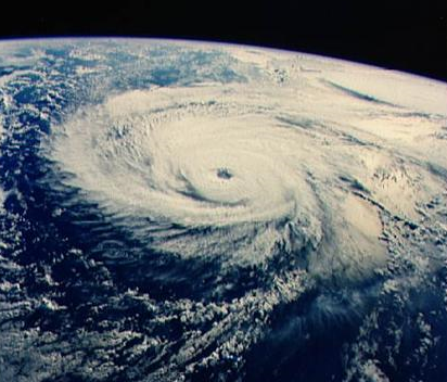
Global Warming Promises Stronger Hurricanes. NOAA researcher Thomas Knutson has been studying the possible impact of a warming climate on hurricanes. His results are a mixed bag: more wind shear aloft (stronger winds blowing over the tropics) should mean fewer hurricanes, but the hurricanes that do form may stand a better chance of intensifying into Katrina-like monsters. He estimates the number of extreme Category 4-5 hurricanes in the Atlantic may DOUBLE by the end of the century. The complete story is here.
“It’s not going to be all short sleeves and barbeques,” Dessler said. “It will be droughts and forest fires.”The entire story is here.
No comments:
Post a Comment