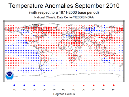
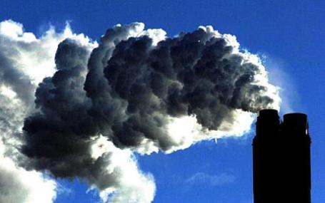
NOAA: Year To Date Global Temperature Ties For the Warmest On Record. Globally, the first 9 months tied 1998 for the warmest combined land and ocean water temperature ever recorded, according to NOAA. An accurate global data set goes back to 1880. NOAA reports that Arctic sea ice reached its annual minimum on Sept. 19, according to the National Snow and Ice Data Center. The average extent of 1.89 million square miles (4.90 million square kilometers) was the third lowest September sea ice extent on record (30.4 percent below average). The annual record was set in 2007 (38.9 percent below average). This year also marked the 14th consecutive September with below-average Arctic sea ice extent. All the details are here.
The World's Strangest Signs. O.K. It's a slow-weather period - not much to point to on the weather map, so I thought I'd post a few strange/funny/bizarre links I stumbled upon Friday. Click here to see a few signs that definitely got lost in translation.

Your Cell Phone Has 18 Times More Bacteria Than A Toilet Handle. Thanks for cheering me up on a Saturday - and remind me not to borrow anyone's phone, no matter how cool the app or game is! The Sacremento Bee did the original reporting - apparently bacteria and viruses buried deep into cell phone cracks and buttons can get onto your fingers - wipe your eyes or pop something into your mouth (without washing first) and you can ingest these various, nasty bugs. Lovely. Talk about "going viral!"


* So far October, 2010 is running 7.5 F. warmer than average in the Twin Cities.
* Last time we've had measurable rain at MSP (more than a "trace"?) September 25 (.02")
* Light jackets return the first half of next week (but the potential for a midweek metro frost has diminished). I still don't see any sub-32 F. readings for the metro looking out through the last week of October. On average MSP experiences its first 32 degree low October 7 - that's the "median date" for the first 32 F. reading, according to the MN State Climate Office.
* GFS model hinting at low to mid 60s the end of next week, from next Thursday through next Saturday.
* Nothing scary brewing for Halloween, at least not yet. Long-range guidance for Oct. 31: Partly sunny, high of 64 in the Twin Cities! That forecast will almost certainly change in the coming days, but right now it appears that our unseasonably mild, September-like weather may hang on through most of October.
A Few Highlights from This Week's Mark Seeley WeatherTalk blog:
* First 2 weeks of October probably the warmest such period since 1963. Only 1920, 1947 and 1963 were warmer.
* 3 dry weeks/row is quite rare, happening (on average) once every 3-4 years. Longest dry stretch at MSP was 51 days, from November 15, 1943 to January 4, 1944.
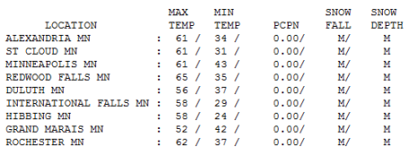
Thank You Sir - May I Have Another? Nope - still not getting tired of this monotonous spell of magnificent weather, a veritable treadmill of sunshine, the 20th day in a row with no measurable precipitation. If we don't see any showers Sunday night we could conceivably go 4 weeks without rain - which happens once every 5-8 years. Very odd, but I'm not complaining. Friday highs ranged from a brisk 52 at Grand Marais to 61 in St. Cloud and the Twin Cities, 65 at Redwood Falls.
Paul's Conservation MN Outlook for the Twin Cities and all of Minnesota:
Today: Generous sunshine, no complaints about the weather. Winds: NW 10-20. High: 66
Saturday night: Partly cloudy. Low: 38
Sunday: Early sun gives way to increasing clouds. Slight chance of a shower or sprinkle Sunday night. Winds: N 3-8. High: 58
Monday: Fleeting shower or sprinkle around the breakfast hour, then clearing, seasonably cool. High: 59
Tuesday: Lot's of sun, another quiet, dry day. High: 56
Wednesday: Bright sun, warmer than average. High: near 60
Thursday: Indian Summer hangs on - blue sky, milder. High: 64
Friday: Plenty of sunshine, running out of superlatives. High: 62
Remarkable October
October: month of long shadows & littering trees. Staring out at the water it's incomprehensible to me that within 90 days daring Minnesotans will be driving their SUVs on an 8" sheet of solid ice. La Nina (cooling of the Pacific) is strengthening, water as cool as it was in 2008. At first blush that would seem to favor a colder, snowier winter from the Upper Midwest to New England. But we're discovering (the hard way) that every La Nina and El Nino is different, unique; it's naive to assume that a harsh upcoming winter is a given. I don't see any frost for the immediate metro area thru next week, we may not see our first official 32 F. reading until late October, 3 1/2 weeks later than usual for MSP.
According to Mark Seeley at the U. of MN, the 1st half of October was the warmest such period since 1963. And a 3+ week dry spell is very unusual, coming once every 3-4 years. A relatively balmy Saturday gives way to more clouds Sunday, a fleeting shower Sunday night as more seasonable air drains out of Canada, but jackets early in the week give way to more 60s by next Thursday & Friday. This will make the winter seem (a little) shorter alright. But winter's still coming. Count on it.

Americans Have Some Strange Ideas About What Causes Global Warming. "Large majorities of Americans incorrectly believe that completely irrelevant behavior would reduce global warming. For example, an astounding 67% believe that reducing toxic waste, or banning aerosol spray cans (69%) would be effective. When asked which one action would do the most to reduce global warming, switching from fossil fuels to renewable energy sources was the action most selected – but by only 36% of those polled. Not so much because the remaining 65% agree on something that might do it better, but more that a great variety of wacky notions compete for the job." The complete article from cleantechnica.com is here

No comments:
Post a Comment