* 80 is not out of the question Friday afternoon, nearly 20 degrees above average.
* Weather slowly sours over the weekend. Shower/T-shower possible Saturday PM, showers likely on Sunday.
* Series of cooler fronts arrive next week, light jacket weather returns by midweek.
* No cold fronts (or s-s-s-now) in sight.
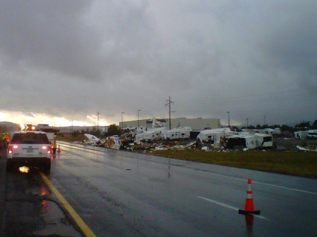
* Freakish weather grips the southwest: flooding, hail and large, violent tornadoes....in Arizona?

Twins-Cast. Another September-like evening is shaping up for Game #2 at Target Field. Expect temperatures falling through the 60s into the upper 50s in time for the 7th inning stretch - clear skies and a light breeze. More like September 7 than October 7.
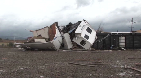
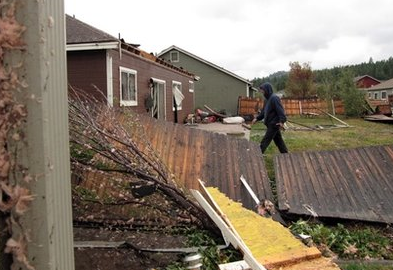
Tornadoes, Hail & High Water (and sweatshirts?) The southwest has been hammered by unusually wet, stormy weather in recent days, but what struck me most about this (Twitpic) photo was the poor guy bundled up in the hooded sweatshirt. In Arizona? It should be in the 80s and 90s - but temperatures have been stuck in the 50s & 60s.
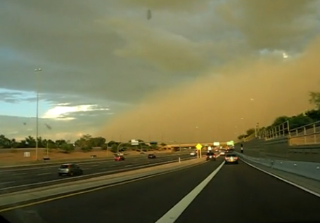
Dust Storm! How'd you like to be driving along and see THIS swirling down the freeway? Severe thunderstorms in Arizona whipped up 40-60 mph winds, which in turn kicked up an eerie-looking (orange) wedge of desert dust and sand, capable of taking paint of cars. The YouTube video of the dust storm that swept into Mesa, AZ is here.
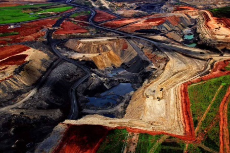
Earth From Above. This has precious little to do with weather, but a friend sent along this amazing web site, showing the work of Yann Arthus-Bertrand. BTW, this is a shot of a coal mine in South Africa - amazing.
September Recap. The MN State Climatology Office has a great summary of September weather in Minnesota from Greg Spoden. Statewide it was the wettest September on record (an average of 6.46"). That breaks the old record of 6.2" in 1900. To read a good overview of the month that was - click here.
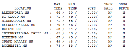
Another Stunner. Add Wednesday to a growing list of remarkable days - we are on track for the best week of Autumn, no question. Under a brilliant blue sky the mercury reached 71 in St. Cloud and the Twin Cities, 73 at Rochester.
Paul's Conservation MN Outlook for the Twin Cities and all of Minnesota:
Today: Blue sky, as good as it ever gets in early October (or any other time of the year!) Winds: W 5-10. High: 75
Thursday night: Mostly clear and comfortable. Low: 52
Friday: More like early September. Plenty of sun, unseasonably warm. High: near 80
Saturday: Still unusually warm with morning sun giving way to a partly sunny afternoon - slight chance of a shower or T-shower. High: 78
Sunday: More clouds than sun, unsettled - a few scattered showers likely. High: 74
Monday: Lingering clouds, a couple of showers nearby. High: 69
Tuesday: A mix of clouds and sun, closer to average in the temperature department. High: 62
Wednesday: Feels like October again. Mostly cloudy and windy with a few sprinkles/showers up north. High: 57
Another day in Weather-Paradise. Blue sky, light winds, little in the way of humidity, fewer bugs - highs flirting with 70. Getting sick of this yet? Me neither. Two more extraordinary days are shaping up, low to mid 70s today, a chance of seeing 80 degrees close to home Friday afternoon, more than 20 degrees above average! That's typical for late August or early September. Soak it up - the weather is still on track to sour over the weekend, a cold swirl aloft (one of those dang-blasted "upper air disturbances") may destabilize our skies just enough for a pop-up instability shower or T-shower Saturday afternoon - more numerous showers on Sunday, maybe a few hours of rain. At least it will be lukewarm rain. If the sun stays out through midday Saturday (likely) we should see some upper 70s. More clouds will keep us a few degrees cooler Sunday, but still well above average for this time of year.
Next week looks like a reality check: a progression of cooler fronts dragging Canadian air south in their wake. Nothing I'd qualify as a "cold front", but light jackets return by midweek, highs returning to the 50s (north) and low 60s (south). Closer to average weather for early/mid October. I still don't see any major storms, no heavy/sustained rain, certainly no frozen, crystalline precipitation of a flakey variety through October 22.
CPC (Climate Prediction Center) is hanging in there with its forecast of a warmer than average October for Minnesota, and gazing at the maps that's not hard to believe. Most years fall lingers an extra week or two longer than it did a generation ago - we often don't get into coat & snow tire weather until sometime in November. I have a hunch that's going to be the case this year. October is shaping up to be relatively kind and gentle, more like a delayed September.
Enjoy the sunshine - GO TWINS!!!
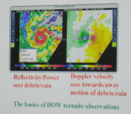
DOW. Doppler On Wheels. Normally tornadoes are much to small and brief to show up on conventional Doppler radar, whether it's National Weather Service (NEXRAD) Doppler or local TV station systems. But scientists at the University of Oklahoma have a DOW, a "Doppler On Wheels", that literally pulls up within 1/2 to 2 miles of a tornado on the ground. The result: incredible resolution, and the ability to see the actual tornado itself. The image to the left shows the debris from a powerful tornado, with a small, calm "eye" in the middle of the twister. Incredible.
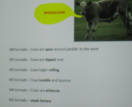
Weather Geek Humor. You've heard of the Fujita scale for rating the damage done by tornadoes? It goes from EF-0 to EF-5. Now there's the "Moojita Scale." Enough said.
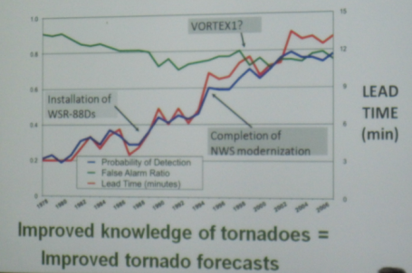
Getting Better. The average national "lead time" (time from when a tornado is detected/warned and when it actually hits) has improved from 3 minutes to nearly 13 minutes in recent years. The installation of NEXRAD Doppler certainly helped, the "false alarm" rate has come down (slightly), but there's still room for more improvement.
Dr. Joshua Wurman of the Center for Severe Weather Research and the creator of the Doppler on Wheels (DOW) came to St. Cloud State today and gave a couple of presentations, some for the students of the meteorology department and one aimed for the public. In these presentations he talked on a variety of subjects, including how he came about the idea of creating the DOW to the original purpose behind it and the variety of missions that the vehicle has been on, including the recent VORTEX 2 governmental project.
Dr. Wurman talked about how different radars can be too fuzzy or not update rapidly enough to capture tornado genesis or even a rotating mesocyclone (one of the limitations of the WSR-88 if the storm is either too far away or forms too quickly, like the Rogers tornado years ago), and how one of the main drives behind the creation of the DOWs was to study tornadoes unlike other radars can. He also talked about his formation of the Rapid DOW, to scan storms and retrieve more volumes (levels) of the storm at a quicker speed so that they could then study the formation of tornadoes instead of having one level of a scan, then get the next scan another layer up a minute later after the storm has progressed in the life cycle and not getting crucial information in between about the storm.
Dr. Wurman explained that since the DOW project started about 15 years ago, the vehicles have seen between 160-170 tornadoes, about 15-20 of them with the VORTEX 2 project which was aimed at better understanding tornado formation and to hopefully push the lead time out for tornadic storms. Part of Dr. Wurman's research is also to study the lower level winds of a tornado in hopes to come up with an even better Fujita Scale (yes, different from the current Enhanced Fujita Scale) and hopefully be able to better warn areas that would be impacted by tornadoes, especially since there is currently little ability to forecast the intensity, duration, and size of tornadoes, unlike we can with hurricanes.
The DOW has also found other research usages. The DOW has been used in the past few years to study landfalling hurricanes and the composition of those storms. The vehicles have also been used to study turbulence for aircraft in Alaska, and to help map out hot spots and tell firefighters where to stay away from during wildfires in Colorado. They are planning a trip to the Lake Erie and Lake Ontario areas to study lake effect snow bands during the winter.
* Thanks to D.J. Kayser, a meteorologist at the University of St. Cloud (and a valued intern/assistant at WeatherNation), for this report. He attended Wednesday's severe storm conference with Josh Wurman and sent me this recap.
- A decline in summer Arctic sea ice and western mountain glaciers;
- An increasing risk to people and property from weather extremes;
- An increasing risk of exposure to vector-borne diseases;
- Hydro generation potential increasing in central Quebec, but declining in parts of B.C. and Ontario;
- Livelihoods of some resource-dependent communities at risk;
- Less winter heating and more air-conditioning;
- Arctic tourism increasing with ice-free access;
- Security and resource-claim issues heightening in the Arctic;
- Increasing demand for humanitarian and foreign aid due to additional populations affected by climate-related natural disasters.

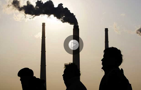
The Carbon Dioxide Precipice. At the beginning of the Industrial Revolution (early/mid 1800s) the amount of carbon dioxide in the atmosphere was roughly 280 ppm (parts per million). Recently we just passed the 387 ppm mark. The world's oceans have been able to soak up some of the excess CO2, but the increasing levels of carbon, methane and other greenhouse gases are having an impact, especially at northern latitudes. An interesting editorial in the L.A. Times here.
No comments:
Post a Comment