* Beautiful weather lingers into Saturday morning, temperatures 10-20 degrees above average.
* 80 F. not out of the question Friday afternoon in the Twin Cities, typical for late August.
* Weekend outlook has soured - an "upper level disturbance" (puddle of unusually cold air aloft) will spark scattered showers Saturday afternoon into Sunday, couple hours of rain possible each day - still relatively mild.
* A colder front brewing between Saturday, the 16th and Wednesday, the 20th of October: highs in the 40s and 50s, but readings may rebound into the 60s again after the 20th of October.
"A-Train" Satellites Search for 770 Tons Of Dust In The Air. According to NASA - every year an estimated 770 TONS of Saharan dust blows into the Atlantic Ocean, swept thousands of miles downwind, reaching South America, even the southeastern USA. The impact of this steady stream of African dust on hurricane formation, ocean currents and climate change is still largely misunderstood, one of many lingering meteorological mysteries.


Expert: Texas Is Getting Hotter Due To Global Warming. A researcher at Texas A&M has data showing much of Texas warming at the rate of 1 degree F/decade. He predicts that "triple-digit heat will become the norm in Texas, and 115 degree readings won't be surprising." More from USA Today here.


Twins Play-off Weather Outlook
This Evening (Target Field) 7:37 pm: Clear and unusually mild. 55-60 F.
Thursday Evening (Target Field) 5:07 pm: Clear and relatively balmy (for October). 56-63 F.
Saturday Evening (Yankee Stadium) 7:37 pm. Mostly clear and dry. 58-63 F.
Sunday (Yankee Stadium) TBD. Sunny and pleasant. High: 67


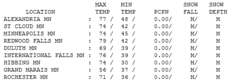
Paul's Conservation MN Outlook for the Twin Cities and all of Minnesota:
Today: Sunny & spectacular. Winds: NW 10-15. Evening temperatures falling into the upper 50s. High: 70
Wednesday night: Clear and a bit cooler. Low: 44
Thursday: Blue sky - feels like mid September. High: 71
Friday: Sunshine, even milder. Hard to remain cooped up indoors. High: 78 ( a few thermometers near 80!)
Saturday: Sunny start, clouds increase with a few PM showers. High: 73
Sunday: Unsettled, a few scattered showers likely. High: 71
Monday: More clouds than sun - another shower or two in the area: 74
Tuesday: Partly sunny - another round of showers possible late. High: 73
THIS is the Minnesota I wish the rest of America could appreciate. While the northeast gets clobbered with wind-whipped rain (and even some snow over the higher terrain of Tennessee and West Virginia) and flooding rains grip California and Arizona - the Upper Midwest has been transformed into an oasis os high pressure: warming, sinking (drying) air - a streak of sunny, spectacular weather which will leave us with some of the best weather in North America through at least the first half of next week. 8-10 dry, sunny, Septemberlike days in a row? Pretty unusual to be seeing weather this nice, for this long, during what will probably wind up being the first HALF of October. We had a wet, stormy, fairly wild summer (can't shake that 145 tornadoes statistic out of my mind just yet). I guess we were due for a cosmic break, and it's here. If you can't sneak outside today, you'll get another shot Thursday - and Friday - and much of Saturday, Sunday, Monday and Tuesday of next week. Amazing. A taste of San Diego or Palm Springs - in Minnesota - in October?
Only one (small) fly in the weather ointment. Computer models are hinting at an "upper air disturbance", a swirl of unusually cold air aloft, pinwheeling overhead Saturday, destablizing our skies enough for a few showers Saturday afternoon into Monday of next week. I don't think it will be a steady rain - but I'm not nearly as optimistic about the weekend as I was yesterday, plan on at least a couple hours of rain Saturday afternoon and Sunday - relatively mild, but not nearly as nice as the next 3 days. Again, I wouldn't be suprised to see an 80 pop up Friday - best chance south/west of the Minnesota River Valley, toward Windom, Mankato and Albert Lea. These temperatures are forecast to be as much as 20 degrees above average, statistically very significant.
Long range models cool us off (rather noticeably) between October 16-20 (highs sinking into the 40s and 50s), but a bit of a rebound again after the 20th, maybe a few more 60s. No snow in sight, but late-week shorts WILL give way to a reality check 2 weekends from now. Bottom line - make the most of the next 3 days, arguably not only the nicest weather of Autumn, but some of the finest weather of the entire year.
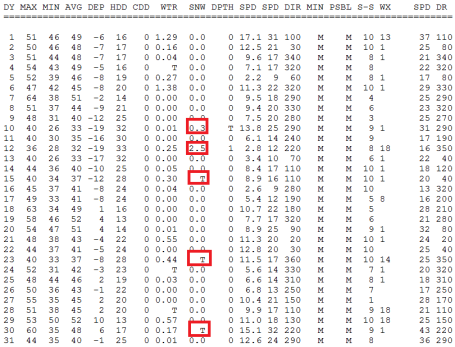
And to think - a year ago we were faced with a much different weather scenario. A year ago (today) the high was a whopping 47. We were faced with a series of clipper-like storms, each one dragging progressively colder air into Minnesota. On October 10, 2009 a coating of snow delighted Twin Cities residents (.3" to be exact). Just two days later, on October 12 a whopping 2.5" of snow fell, enough to shovel and plow and elicit a string of grunts, groans and cries of despair I'd just as soon forget. Not this year - we get a supersized Autumn in 2010. Maybe it's payback for an unusually warm, sticky (and severe) summer. Maybe it's cosmic retribution for the flooding we muddled through in late September. Whatever the reason I hope you can escape your cubicle and soak up what should be some of the finest weather of 2010. Bright sun, WITHOUT the bugs, humidity or wild, raging T-storms. A Minnesota Fall the way it was probably meant to be...
No comments:
Post a Comment