"Pyrocumulonimbus: Fire-Breathing Storm Systems. Click
here to see a fascinating article from NASA, describing the process whereby heat and smoke from wildfires on the Earth's surface can help to spark violent updrafts, which form thunderstorms (cumulonimbus). But these "CBs" are spiked with smoke, in fact the resulting pyrocumulonimbus clousd are capable of injecting smoke into the stratosphere, the stable upper reaches of the atmosphere, where smoke particles can linger for years. Who cares? These smoke-inhaling T-storms may have a long-term impact on climate.
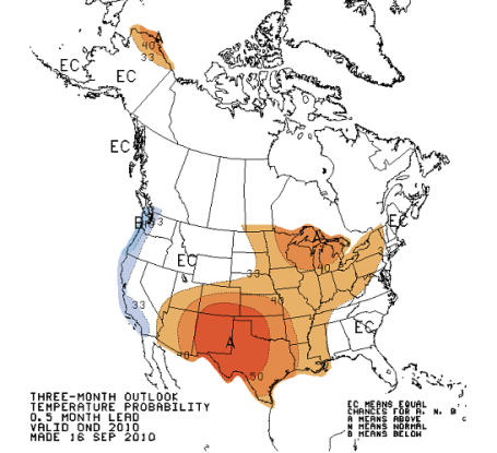
Extended Outlook. It goes without saying to take a 3-month weather prediction with a huge, skeptical grain of salt. Don't bet the farm based on the 3-month outlook. But based on current global patterns (and a strengthening La Nina cooling of equatorial Pacific Ocean water) CPC, the Climate Prediction Center, is predicting a bias toward warmer-than-normal weather over the central U.S. - including Minnesota and Wisconsin, through December. We'll see how that works out. More from CPC
here.
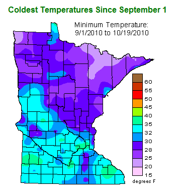
Evidence Of The "Urban Heat Island". All those purple counties over the northern half of Minnesota have already seen nighttime lows dipping into the 20s, but not the immediate Twin Cities metro, the Rochester area, and a small region of southwestern MN, where the mercury has yet to dip to freezing. Asphalt and concrete in the heavily developed Twin Cities area retains heat soaked up during the day, slowing releasing it at night, often keeping nighttime temperatures 5-15 degrees warmer than the surrounding suburbs. More data from the MN State Climate Office
here.
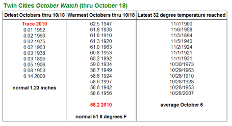
Driest Start To October On Record. We should have picked up a cool 1.23" of rain during the first 18 days of October. So far this year: a trace of rain in October.
Data from the National Weather Service and the MN State Climate Office suggests that, so far, we're enjoying the 14th warmest start (first 18 days) on record. The coldest nighttime low so far at MSP: 38 F. on October 3. The latest 32 F. reading on record? November 7, 1900. Chances are the first frost/freeze of the season will come nearly 3 weeks later than usual this year.
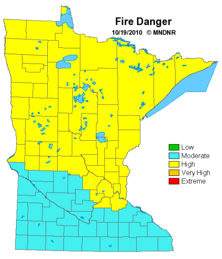
Fire Risk. According to the Minnesota DNR there is a high fire risk over the northern 2/3rds of the state, generally north of I-94. A high risk means "fires start easily and spread at a rapid rate." 25 days/row with no measurable rainfall is having an impact - stating the obvious: it's tinder-dry out there right now, and will remain so until we get some rain in here (next week). More from the Minnesota DNR
here.
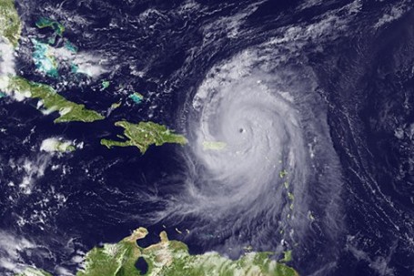
Low Pressure Systems Have Spared the United States This Hurricane Season. 16 named storms, 9 hurricanes, 5 of which became major, category 3 storms, yet no direct strikes on the USA? We've been exceptionally lucky this year, enough wind shear aloft (and the core of the jet stream far enough south to nudge just about all the hurricanes out into the North Atlantic). An above-average hurricane season was predicted back in June, and that came true. But nobody could forsee that all the hurricanes would veer away from America. We dodged a bullet, no question. More on the quirky hurricane season of 2010
here.
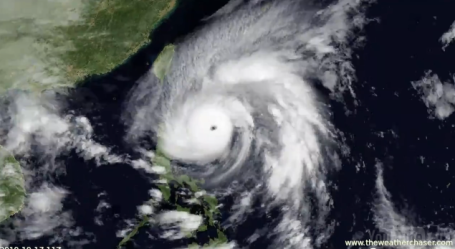
Time Lapse of Super Typhoon Megi. The strongest typhoon/hurricane of the year (in any ocean), Megi producted sustained winds close to 200 mph as it slammed into the northeastern coastline of Luzon, in the Philippines. An amazing satellite loop of the superstorm is
here, data courtesy of Japan's JMA MSAT. More on the severe damage in the Philippines from the China Post
here.
Time Lapse. Check out
this eye-opening HD YouTube time lapse of the approach of Super Typhoon Megi in Hong Kong.
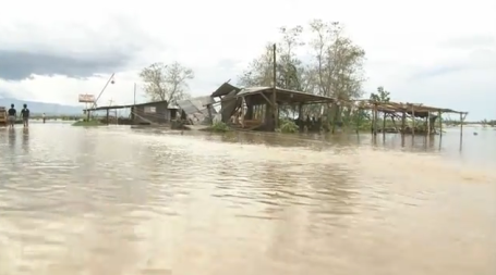
Philippine Flooding. At least 4 deaths are being blamed on Super Typhoon Megi, which is a minor miracle, considering the size and severity of the storm. Click
here to see YouTube footage of severe flooding along the Cagayan River, in Tuguegarao City.
Malarial Mosquitoes Helped Defeat British In Battle That Ended Revolutionary War. Who knew? The weather has proven to be a major factor in major conflicts and wars for thousands of years. The Washington Post has an intriguing
story about how, in the definitive (final) Battle of Yorktown on October 19, 1781, the Revolutionary Forces had an unlikely ally: mosquitoes. It seems that American forces had built up a slight tolerance to malaria over time, while British forces were knocked flat by the "ague", as malaria was referred to. A very interesting read.
Global Temperatures Continue To Rise. USA Today has a
story focusing on NOAA's recent declaration that the first 9 months of 2010 tied 1998 for the warmest such period on record. The big difference? 1998 was the most extreme El Nino warming ever observed over the Northern Hemisphere. In 2010 we had a weak El Nino that turned into a moderate La Nina (cooling) during late summer and autumn, and yet atmospheric and ocean temperatures still reached record levels. NOAA has more details
here.
The Word's First BILLION Dollar Home. Recession? What Recession? The world's 4th richest man just built a high-rise home in Mumbai (India), 27 stories (all for him!) - including 6 floors of parking, 3 helipads ('cause one just isn't nearly enough), multiple swimming pools. We just found a new definite for the phrase "wretched excess." More on the megahome
here.
"Books Will Be Gone Within 5 Years." Now I love my iPad as much as the next guy, but books on the verge of becoming obsolete? I seriously doubt it. Then again Nicholas Negroponte has a pretty good track record. He argues (in
this CNN video clip) that digital devices will render the dead-tree versions obsolete within 5 years. Do you agree?
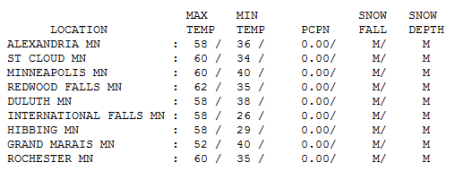
Loving October. It still feels more like the third week of September out there. Under a partly to mostly sunny sky highs reached 58 at Alexandria, Duluth and Hibbing, but 60 at St. Cloud and the Twin Cities, 62 at Redwood Falls, a good 5-10 degrees warmer than average statewide.
Paul's Conservation Minnesota Outlook for the Twin Cities and all of Minnesota:
Today: A mix of clouds and sunshine, gusty and milder. Winds: W/NW 15-25. High: 63
Wednesday night: Partly cloudy and chilly - frost over much of central MN late. Low: 37
Thursday: Plenty of sunshine, a bit cooler. High: 58
Friday: Best day in sight. Blue sky, a definite taste of Indian Summer statewide. High: 66 (70 possible south/west of the MN River Valley).
Saturday: Clouds increase, a few showers possible by PM hours (especially south of the metro area). High: 59
Sunday: Mostly cloudy - probably dry. High: 57
Monday: Rain developing during the day, soggy and seasonably cool. High: 55
Tuesday: Windy and cooler with lingering rain showers - a potentially foul day. High: 52
*
Halloween Preview: Windy and chilly with sprinkles (even a few flurries north). Highs: 45-52 F. Winds gusting to 20 mph. Evening Trick Or Treat temperatures falling through the mid 40s with a wind chill in the 30s. Yes, it will feel like late October.
Good weather news
"October's poplars are flaming torches lighting the way to winter," marveled Nova Bair. The leaves are leaving, people hesitant to check out the 7-Day Outlook. Nobody wants the party to end. The weather has been eerily quiet for nearly a month, no watches or warnings. This is the driest start to October (first 19 days) on record for MSP.
Duluth has yet to see any flurries, and even though flakes have been spotted up at International Falls, no accumulating snow has been reported - yet. Is this the proverbial calm before the storm? Possibly. We'll see a series of soggy storms next week, and in less than a week or so it may be cold enough aloft for a few flurries, especially up north. Halloween 2010 looks windy & cool with sprinkles (flurries north), highs stuck in the 40s and 50s.
No Halloween blizzards this year. In the meantime sunshine lingers into Friday, when highs surge well into the 60s - 70 quite possible near Mankato & Windom.
Meanwhile residents of the Philippines are cleaning up after Super Typhoon Megi, an intense category 5 hurricane. Sustained winds around the calm eye may have approached 200 mph, roughly equivalent to an EF-4 tornado that's 50 miles wide.
Gone With The Wind. Houses Test Hurricane-Force Gusts. Two houses stand side by side as giant fans create wind gusts of 110 mph, about the same as a Category-3 hurricane, to test the houses' resistance to the winds, in Richburg, S.C., on Tuesday. The house at left was built using conventional materials and standards, and the other built with fortified materials and using hurricane-resistant technology, like strapping to tie the floors and roof together to withstand more winds. USA Today has an interesting
story about A South Carolina research project that uses 100 giant fans to mimic the effects of a major hurricane, testing new construction methods that will stand up to even the most intense storm.
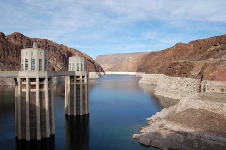
Global Warming, Drought & The Grim Reaper. The Colorado River Basin, which provides water for thirsty cities like Phoenix, Las Vegas and Los Angeles, may be the second most vulnerable region to climate change across North America, second only to Alaska. More than 25 million Americans get their water from the Colorado River, which is in the midst of a long term drought, a perpetual drought which may be the norm in years to come. More on climate change and transformations underway in the Desert Southwest
here. Another story focused on the long-term drought facing major cities dependent on the Colorado River
here.
In Kansas Climate Skeptics Embrace Green Energy. Don't mention global warming or Al Gore to residents of Salinas, Kansas. There is still considerable skepticism about climate change, but turning the argument around, making it about thrift, patriotism, spiritual conviction and economic prosperity and people will listen. The "Climate And Energy Project" is reframing the conversation, making it less about the perils of climate change, and more about weaning ourselves off of foreign crude, making ourselves more energy-independent, and saving money in the process. Separating out climate science from energy policies seems to be key for many people. An interesting read in the New York Times
here.
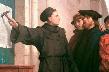
Climate Change "Fraud" Letter: A Martin Luther Moment in Science History? Esteemed physicist Harold Lewis is calling global warming the "most successful pseudoscientific fraud I have ever seen." His resignation letter could mark the unraveling of one of the greatest scientific mistakes in history and the beginning of a needed reformation of the scientific community, according to Anthony Watts in an
opinion piece in the Christian Science Monitor. Dr Lewis has condemned the way politics, ideology and money have suppressed dissenting viewpoints on climate change and "distorted the nature of scientific inquiry." But a massive fraud? I'm keeping an open mind. If a better theory comes along that explains what we're witnessing worldwide I'll be the first to change my tune - in fact there is a HUGE incentive (financial and otherwise) to debunk climate change and prove otherwise. The first scientist that successfully proves something else is going on (other than anthropogenic warming caused mainly by the burning of fossil fuels) will become an instant celebrity and earns mega-millions. I keep waiting for that to happen, but so far the other 'explanation", solar activity, volcanoes, etc has not passed the muster of scientific peer review. 97% of peer-reviewed (PHd) climate scientists continue to believe that a). the atmosphere is warming, and b). man is most likely the biggest contributor to that warming. That's good enough for me, until a better explanation comes along.


No comments:
Post a Comment