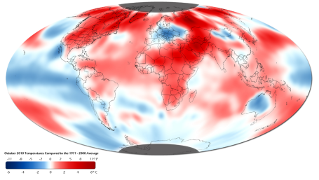
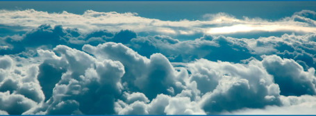
8th Warmest October On Record. Yes, last month was remarkably warm worldwide.
Details from NOAA: "
October ranked the eighth warmest October on record. The first 10 months of 2010 tied with the same period in 1998 for the warmest combined land and ocean surface temperature on record. The global average land surface temperature for January–October was the second warmest on record behind 2007. The global ocean surface temperature for January–October tied with 2003 as the second warmest on record behind 1998. La Nina continues to be a significant factor in global ocean temperatures."
 Just Like Old Times
. I just wanted to say thanks to the 'CCO crew for making me feel welcome Wednesday night, when I stepped back into the station for the first time in 2 1/2 years. Don Shelby asked me to come back and do one last show on the air with him before he retires and passes the baton to Frank & Amelia next Monday. How can you say no to The Donald? Yes, Monday's show should be a real tear-jerker, at least for anyone who has watched Don for any part of his (amazing) nearly-40 year run here in the Twin Cities. I had a great time; it felt more like a little mini-reunion, seeing friends I hadn't seen in a long time. Surreal? Yes. But Chris helped me navigate the new weather system and I was able to bumble my way through a 3:00 weather segment, with time leftover to reminisce about shows (and bad haircuts) gone by. I had a great 10 year career at 4, and to be perfectly honest, an equally great time at KARE for 11 years. No regrets. But things usually happen for a reason - I subscribe to the theory that there are no coincidences. I'm probably better suited to the perils and crazy-pleasures of entrepreneurship, dreaming up and launching new (weather-related) companies. That's where I get my self-esteem. I loved the on-air years, met some incredible people along the way - but (as I told Don on and off the air), if you love what you're doing, if you're passionate, the future will kind of take care of itself. More (thoroughly unremarkable) moments from Wednesday night's show
here.
 White Thanksgiving?
 The models are contradictory (what's new?) but there is a VERY good chance we'll have a few inches of snow on the ground in time for Thanksgiving. The GFS prints out a couple of inches Monday, another 2-4" of (powdery/fluffy) snow possible Wednesday as the core of the Arctic air arrives. Yes, it usually doesn't get bitterly cold without an introductory burst of snow. This time should be no exception.
*
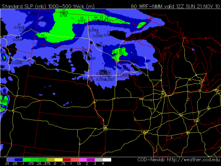
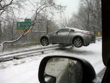
Travel Weather Alert. O.K. It's way too early to even think about winter storm watches and advisories, but I have a (very strong) hunch that we will see accumulating snow next Wednesday, probably a few inches, probably enough to shovel and plow. Unlike last Saturday's wet, slushy snow, next week's snowfall will be light and powdery (snow/rain ratio something like 20/1, maybe 30/1). Who cares? When it's this cold (upper teens to around 20) the chemicals MnDOT puts down on the roads works much slower.
I'm going to go out on a limb and predict that travel next Wednesday will be VERY slow, with a rash of fender-benders and commute times 2-4 times greater than normal. If you're expecting someone in Wednesday leave lot's of extra time to get around the state.
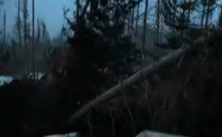
British Columbia Wind Storm. An incredibly intense storm off the west coast of Canada has produced 100 mph wind gusts, leveling entire forests in British Columbia. Quoting from the
YouTube photographer: "
Wind storm In Mackezie, British Columbia.. levels whole forests, gusts reaching well over 100 miles per hour smashing windows in houses."
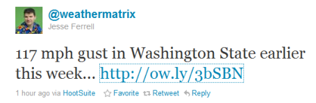
Category 3 Wind Speeds? Cliff Mass is a weather enthusiast with a great weather
blog focused on Pacific Northwest weather. He reports a 117 mph wind gust at Stevens Pass, Washington state - roughly equivalent to winds in a category 3 hurricane! He had an interesting observation, "
one of the most entertaining aspects of this and other windstorms is the firework show that occurs when the winds start blowing. Lightning? Nope. The multicolor displays are caused by transformer fuses or cutouts (see picture) When a circuit get grounded by a branch or some other object, these fuses can blow--cutting off the circuit with a bright flash. Then the associated neighborhood goes dark."
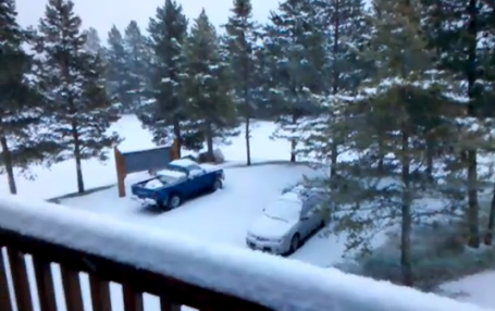
Big Sky Country. Yes, it's starting to look like winter out there. Skiers and snowboarders at Big Sky Mountain Meadows have an itch that a scratch won't reach right about now, after a fresh 6-12" of Montana powder fell earlier this week. The YouTube clip is
here.
 Sunday Slush
. The latest NAM/WRF model spits out about .10" liquid, roughly 1" of slushy snow on Sunday, best chance of some slippery roads coming Sunday morning.
 Nuisance to Plowable?
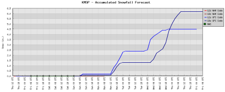
 The GFS model prints out 1-2" of snow by midday Tuesday over the northern/western suburbs of the Twin Cities to St. Cloud, maybe as much as 2-4" west of the metro, near Willmar, Hutchinson and Windom.
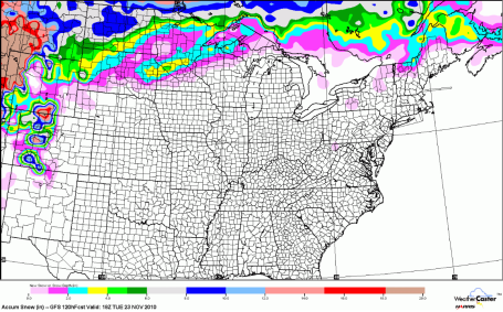
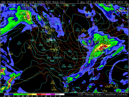
Thanksgiving Slop-Storm Out East? Long-range models show next week's surge of arctic air spinning up a major storm for the northeastern U.S. the end of next week, potentially heavy snow for Pittsburgh, Buffalo and Albany, mostly-rain from Boston and New York to D.C with a zone of ice/slush/sleet sandwiched in-between. There will be some travel delays if you're heading east next week - you'll want to keep an eye on the weather maps. More on the potential storm from Accu Weather
here.
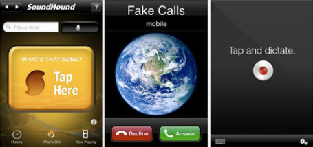
Best iPhone Apps. I know - highly subjective, but David Pogue from the New York Times does a pretty good job weeding out some of the best goodies to have on your phone. Worth a
look.
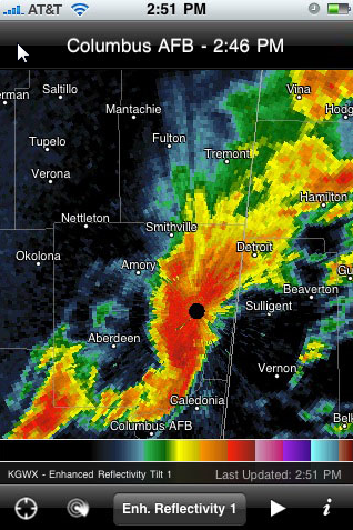
Radarscope. My favorite weather app? This is near the very top of the list. It costs $9.99 (one-time charge) and it's worth every penny. You can easily navigate to any NWS Doppler radar in the lower 48 states, animate (loop) the radar, see nearby warnings, even call up "radial velocity" (to show areas of possible rotation during tornadic situations). It's a definite keeper. More info on the Radarscope app
here.
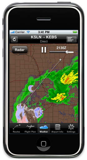
Pilot My-Cast. If you're looking for a top-of-the-line meteorological tool available anytime, anywhere - check out the Pilot My-Cast
app. It's also $9.99, but there is a level of detail with this app you won't find elsewhere, including 1 km. visible clouds loops, real-time lightning and high-resolution Doppler radar information. Even if you're not a pilot you will come to rely on this app.
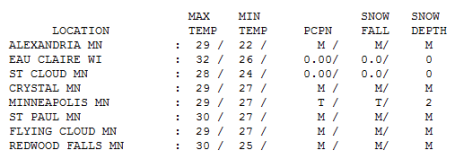
A Trace! Last Saturday's 8" snowfall has dwindled to a "trace" as of 7 pm Thursday, the result of daytime highs consistently above 32 F. all week long. Under a mostly-gray, somber-looking November sky highs ranged from 28 at St. Cloud to 29 in the Twin Cities to 32 at Eau Claire, WI - nearly 10 degrees colder than average. Friday will be 5-10 degrees warmer as a clipper blows through town, mild south/southwest winds turning back around to the northwest by afternoon - meaning cold (but dry) weather for Friday evening football games. Take a coat (and a warm blanket).
Paul's Conservation MN Outlook for the Twin Cities and all of Minnesota:
FRIDAY: Peeks of sun, windy and slightly milder ahead of a clipper. Winds: W/NW 15-25. High: 37
FRIDAY NIGHT: Gusty, turning sharly colder. Low: 18
SATURDAY: Cold, sunny start -clouds slowly increase. High: 28
SATURDAY NIGHT: Chance of light snow/ice/rain late. Low: 26
SUNDAY: Wet snow tapers to flurries. Potential for about 1" of accumulation with some slippery roads, especially morning hours. High: 37
MONDAY: Chance of light snow, probably no big deal. High: 31
TUESDAY: Mostly cloudy, getting colder. High: 26
WEDNESDAY: Period of light snow possible - roads may be very slippery. High: 19 (windchill in single digits).
THANKSGIVING DAY: Cold sun, Indigestion Alert. Low: 7. High: 18
FRIDAY (26th). Plenty of sun, still numbing. High: 25
SATURDAY (27th). Chance of light snow - nuisance accumulation possible. High: 30
SUNDAY (28th). Mostly cloudy, closer to average temperatures for late November. High: 33
Holding Our Breath
Storms, given a choice, PREFER to come on major holidays, when they can wreak the most havoc. Thanksgiving is a meteorological bulls-eye, the most traveled holiday of the year. What can possibly go wrong?
According to the State Climate Office the Twin Cities picks up measurable snow every 5 years or so; 1 in 3 Thanksgivings have at least 1 inch of snow on the ground. The last time we had 1" of snow: 2000.
Enjoy 30s (even a shot at 40 today, again Sunday) because next week will feel like the second week of January. By midweek highs will be stunted in the teens, lows dipping below zero up north. What we like to call a "character-building" airmass. Thanksgiving Day will start out in single digits, a "high" in the upper teens, possibly the coldest Turkey Day in 21 years.
A surge of southern moisture sparks a little rain Sunday, mixing with ice and snow up north, maybe an inch of slush for St. Cloud, Brainerd & the far northern suburbs. Another burst of fluff is possible Monday, again next Wednesday as the core of the numbing air approaches. A major slop-storm is brewing for the northeastern U.S.
The latest guidance is strongly hinting at some accumulating snow Monday (1-3"), maybe another 2-4" next Wednesday, probably enough to shovel and plow. With temperatures in the upper teens the chemicals MnDOT puts down on our highways will be far less effective than when readings are dose to 32 F. Bottom line: expect travel problems next week, especially Wednesday. Talk about lousy timing. The good news: The sun should return Thanksgiving Day, travel should be much better for "Black Friday", the big shopping (nightmare) after Thanksgiving, and the mercury should recover to near freezing the weekend after Thanksgiving - you will regain some feeling in your extremities by then.
But next week will be a preview of January. Truly. Temperatures 20 degrees below average - enough snow to gum-up pre-Thanksgiving travel. Maybe I'll have some better news tomorrow - but I'm starting to get a bad feeling about travel conditions next week (especially next Wednesday).
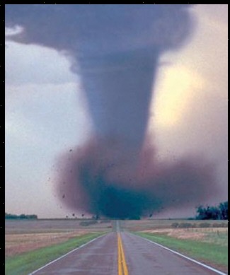
How Do Tornadoes Damage Homes? I found an interesting
post related to tornadoes from the Baltimore Sun - and how they actually produce the majority of their damage. Is it the sudden drop in pressure or the almost instantaneous spin-up in wind speed fro 0 to 125 mph in a matter of seconds, or both simultaneously?
10 Hot Careers For Recent College Graduates. App developers, graphic artists, OHS specialists - these are a few of the "hot" careers for recent college grads, according to a long (but good)
article from michigandailyy.com. A worthy read, especially if you're looking for ideas after graduation.
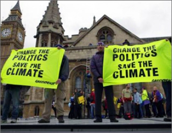
Coverage Of Climate Summit Called Short On Science. From an eye-opening
article in the Washington Post:
OSLO -
Less than 10 percent of the news articles written about last year's climate summit in Copenhagen dealt primarily with the science of climate change, a study showed on Monday.
Based on analysis of 400 articles written about the December 2009 summit, the authors of the report for Oxford University's Reuters Institute for the Study of Journalism called for a rethinking of reporting on future such conferences.
Climate Change. Forget It. In the end the pragmatists may win out. The argument will shift from the science of climate change to climate security and energy independence. A thought-provoking commentary
here.
Outgoing Republican Blasts Global Warming Skepticism. From an
article at rawstory.com: "
An outgoing Republican congressman attacked his conservative colleagues for ignoring the problems the United States may face due to climate change at a House Science subcommittee hearing Wednesday. "I would also suggest to my Free Enterprise colleagues — especially conservatives here — whether you think it's all a bunch of hooey, what we've talked about in this committee, the Chinese don't," Rep. Bob Inglis (R-DC), a ranking member of the House Energy and Environment Subcommittee, said. "And they plan on eating our lunch in this next century," he continued. "They plan on innovating around these problems, and selling to us, and the rest of the world, the technology that'll lead the 21st century. So we may just press the pause button here for several years, but China is pressing the fast-forward button."
No comments:
Post a Comment