Turkey Day Blues. Yes, these are the "good 'ol days. Enjoy the 30s, because by the middle of next week it may be 15-20 degrees colder.
Thanksgiving Climatology In The Twin Cities (courtesy of the MN State Climatology Office)
Because Thanksgiving Day occurs at the transition period between autumn and winter, Thanksgiving weather can be balmy to brutal. A typical Thanksgiving Day in the Twin Cities has high temperatures in the 30's and at least a bit of filtered sunshine.
Having a mild day in the 50's on Thanksgiving Day is relatively rare, looking at the historical record back to 1891. A maximum of 50 or more has happened only nine times in 116 years, or about once every 13 years or so. The warmest Thanksgiving Day is a tie of 62 degrees set in 1914 and 1922. The mildest recent Thanksgiving Day is 58 degrees on November 26, 1998.
On the other side of the spectrum, it is common to have a high temperature below 32. The average Thanksgiving Day temperature is right around freezing. What about extremely cold Thanksgivings? It is about as likely to have a minimum at or below zero on Thanksgiving Day, as it is to have a maximum of 50 or above. It has occurred eight times in the past 115 years. The coldest Thanksgiving Day temperature is eight degrees below zero. This has happened three times, 1893, 1905 and 1985.
Measurable snow fell on 25 of the past Thanksgivings back to 1891, about every five years or so. The most snow that fell on Thanksgiving was five inches in 1970.
Historically, about one in three Thanksgivings have at least one inch of snow on the ground. The deepest snow pack is a tie with 1921 and 1983, both with 10 inches on the ground by Turkey Day.
The last time there was an inch of snow on the ground in the Twin Cities on Thanksgiving Day? 2000.
It occasionally rains on Thanksgiving Day as well. In 1896, a two-day event in the Twin Cities doused Thanksgiving travelers with nearly three inches of rain
 Thanksgiving Day Weather in the Twin Cities since 1983:
Coldest Thanksgiving in 21 Years?
Thanksgiving Day Weather in the Twin Cities since 1983:
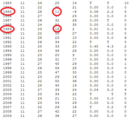
Coldest Thanksgiving in 21 Years? Looking at data from the Minnesota State Climatology Office it appears that Thanksgiving 2010 may be the coldest Thanksgiving Day in at least 15 years, possibly longer. Back in 1995 the high was a meager 20 F. in the Twin Cities.
This will probably be the coldest Thanksgiving Day since 1989, when the high was 18 F. in the cities. It was even colder in 1985 (11 F). It looks like this year highs on Thanksgiving will be in the mid to upper teens, a good 20-25 degrees colder than average. Ugh. More details from the MN State Climate Office
here.
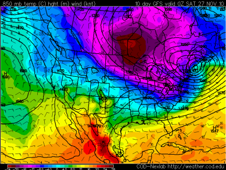
Coldest Thanksgiving In Recent Memory? Predicted temperatures at 850 mb (about 3,500 feet above the ground) are forecast to reach -20 to -24 over the northern half of Minnesota by next Friday (map is valid Friday evening at 6 pm). That could translate into highs in the single digits (north) to teens (southern MN) with the first subzero lows of the season likely by the end of next week. Yes, a little more than a week from now it's going to feel more like mid January. Something to look forward to! See the temperatures forecasts for yourself by clicking the College of DuPage site
here.
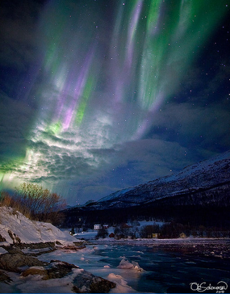
Aurora Watch - Meteor Shower Possible. Increased storminess on the sun is sparking some spectacular sightings of the Aurora Borealis, the "Northern Lights". This photo was taken in Norway - you may want to try to get away from city lights and check it out in the coming nights (when skies will be clear to partly cloudy). The Leonid Meteor Shower peaked last night as Earth passed through cosmic debris leftover from Comet Tempel-Tuttle. You should still be able to see a few lucky shooting stars the next couple of nights. According to
spaceweather.com the Geminid Meteor Shower (scheduled for mid December) may bring 4 to 5 times more meteors!
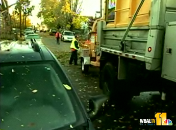
80 MPH Winds - Possible Tornado Near Baltimore. Severe storms in November are fairly common; storms derive their strength from strong north-south temperature contrasts and powerful jet stream winds swirling 4-8 miles above the ground. An especially intense front roared across the northeast Wednesday - sparking a wind gust as high as 80 mph, downing trees, powerlines, triggering considerable damage to at least 200 homes and apartments, especially just northeast of Baltimore, near the town of Parkville. More from Tony Pann, the Baltimore Weather Examiner,
here. Image courtesy of WBAL-TV, which has a clip on the wind damage
here.
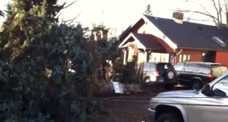
Wild Washington Winds. A major Pacific storm has been buffeting the Pacific Northwest in recent days - winds in Pullman, Washington were clocked as high as 80-90 mph, pulling down large trees, plunging thousands into darkness. The YouTube video is
here.
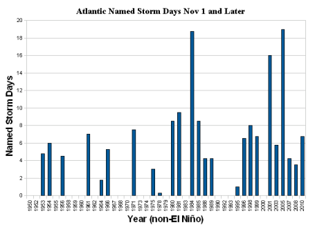
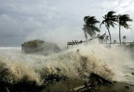
Deadly Late Season Hurricanes In The Atlantic On The Increase? Wunderblog meteorologist Jeff Masters has some interesting data about an apparent uptick in deadly late-season storms, especially over the last 20 years. Quoting Masters: "In the 500+ years people have been encountering hurricanes in the Atlantic and recording these encounters, we are sure of only
twenty November and December storms that have caused loss of life. If we restrict our time window to the past 70 years, when we have a fairly reliable data base of hurricane mortality thanks to the yearly storm summaries published in
Monthly Weather Review, we find only ten late-season storms that killed people. Of those ten, seven occurred in the past twenty years, including the second deadliest late-season tropical cyclone on record,
Hurricane Gordon of 1994, which killed 1145 people on Haiti."
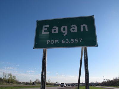
EPA: Too Much Lead In Eagan. Wednesday's Star Tribune had a
story about lead levels in the air over Eagan, one of 16 counties nationwide with high lead levels. The source: Gopher Resource, which processes lead batteries. Officials say the elevated lead levels are confined to a small area immediately surrounding the business.
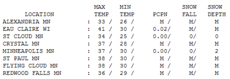 Wednesday Numbers
. Yes, that was the sun up there, visible for a few hours during the morning hours before clouds filled back in. Highs ranged from 33 at Alexandria and 34 at St. Cloud to 37 in the Twin Cities, 41 at Eau Claire. With highs just above freezing every day MSP is down to only 2" snow on the ground.
Paul's Conservation MN Outlook for the Twin Cities and all of Minnesota:
THURSDAY: More clouds than sun, chilly. Winds: SE 10-15. High: 33
THURSDAY NIGHT: Partly cloudy and cool. Low: 28
FRIDAY: Intervals of sun, "milder" as a clipper passes to our north. High: 39
SATURDAY: Colder, plenty of sun early, clouds increase late. High: 29
SUNDAY: Drizzle in the metro area with wet roads, icy 1-2" up north? High: 38
MONDAY: Light snow possible, coating possible. High: 34
TUESDAY: Mostly cloudy, cold wind. High: 27
WEDNESDAY: Gusty and MUCh colder with light snow tapering to flurries. High: near 20 (wind chill: single digits!)
THANKSGIVING DAY: Cold sun, more like January! High: 18 (coldest since 1989?)
FRIDAY(26): Blue sky, potentially the coldest day. High: 15
SATURDAY(27): Partly sunny - good travel conditions. High: 22
SUNDAY(28): Mostly cloudy, a few degrees warmer. High: 25
Arctic Thanksgiving
Payback is a bitter pill. Last week's 60s seems like a meteorological mirage. Saturday's 8-12" storm was the 10th biggest November snow on record at MSP. Any doubt that Indian Summer is finally in our rear-view mirror will be totally erased next week, when we reach for extra coats, blankets (and Antifreeze).
We're tracking a January-like airmass across Canada - the core of the coldest air arrives the end of next week, when highs may be stunted in the teens (single digits up north?)
Based on data from the MN State Climate Office Thanksgiving 2010 may be the coldest since 1989, when the "high" (maximum temperature sounds better) was a meager 18 F. (with 5" snow on the ground.)
Stinging cold seems inevitable, but right now I don't see any major travel headaches between now and Turkey Day, which is unusual. Arctic blasts are usually preceded by surges of snow, the transition from average to (Nanook!) rarely occurs without some accumulation of snow. Models are hinting at a little drizzle Sunday (1-2" icy slush up north) but no "plowable" snowfalls between now & the big travel/shopping weekend after Thanksgiving. Big Cold, but no snow? Somehow it just doesn't seem fair.
Emergency Broadcast System Coming To Cell Phones. The Emergency Broadcast System is getting a makeover, going from TV to your cell phone. Effective November 16 Alcatel-Lucent is creating the Broadcast Message Center (BMC) that will enable federal, state and local officials to send emergency statements to any and all cell phones. With any luck you'll never even know its there. More details
here.
Earth As Art. Wired magazine put together an amazing
collection of photographs snapped in low orbit (215 miles above the ground). You have to see it to believe it - truly incredible. Yes, we live on a beautiful planet. By the way, the photo above is of the Yukon Delta in Alaska.
Diesel, Cleaner, Is Set To Make A Comeback. Remember diesel engines of the past? Smelly, smoky (noisy) - you definitely KNEW when a diesel powered car or truck was passing you - you could HEAR the difference, a loud, annoying clattering sound. No more. Refinements in diesel technology in recent years have resulted in a new generation of (smoother/quieter) diesel engines - according to the EPA diesel vehicles are 20-40% more fuel efficient that regular gasoliine-powered engines. The New York Times has more on the new diesel revolution sweeping the nation (and the world)
here.
How To Live With Climate Change. The somewhat controversial writer, Bjorn Lomborg, wrote a recent
editorial in the Washington Post which is an interesting read - stressing the need for adaptation. Sadly, I have to agree with him on this one. A certain (undefinable) amount of warming and climate change is already "baked into our future." No matter how quickly we reduce or even eliminate carbon gases - additional transformations are likely. CO2 remains in the atmosphere for roughly 100 years; the amount of greenhouse gases have spiked by roughly 38% since pre-industrial times, much of that increase in just the last 50 years.
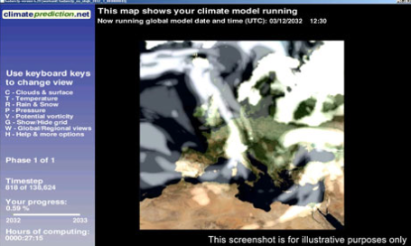
Tapping Your Home Computer To Predict Climate Change. "WeatherAtHome" is an ambitious program designed to harness the computing power of hundreds of thousands of personal computers around the world feeding data to the Met Center in the U.K. to try and get a better handle on future trends. "
Since its launch in 2003, climateprediction.net has harnessed computer time donated by hundreds of thousands of volunteers to run Met Office climate models and explore the uncertainties in global climate predictions in unprecedented depth. This new experiment takes results from these and other modelling experiments and uses them to drive much more detailed models simulating the changing weather in, initially, three target regions: Europe, the western United States and southern Africa." More on the climateprediction.net program
here.


No comments:
Post a Comment