* Advisory in effect today for the Twin Cities metro area.
* 1-2" snow likely, roads become increasingly icy as temperatures fall through the 20s.
* 4-8" possible far western/northern MN.
* Blowing/drifting more of a problem the farther north/west you travel away from the metro area.
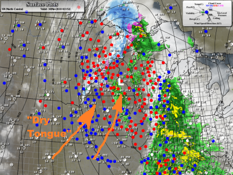
Dreaded "Dry Tongue". Snow enthusiasts are shaking their heads, wondering "what happened"? Half an inch of rain fell Monday afternoon (which could have translated into 3-5" of slushy snow had the temperature been 3-4 degrees colder). By the time it was cold enough for snow - a surge of dry air from the Desert Southwest got tangled up in the storm's circulation, cutting off the heaviest, steadiest snow over the southeastern third of Minnesota.
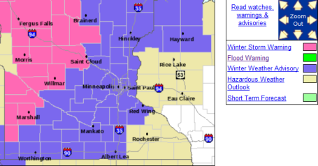
 Latest Warnings - Advisories
. The Twin Cities metro area is under a Winter Weather Advisory. Most of the precipitation will fall as rain today - by the time it's actually cold enough for snow tonight a surge of dry air aloft should cut down the heaviest precipitation. But on the cold side of the storm track mostly snow is expected over western and northern MN from late afternoon through Tuesday afternoon - some 4-8" amounts are possible. Central Minnesota is under a Winter Storm Warning as well, calling for some 2-3" amounts. Tuesday morning travel will be rough, the farther north/west you travel on Highway 10, I-94, Highways 7 and 12 - the worse travel conditions should be. The latest on the warnings from the NWS is
here.
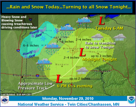
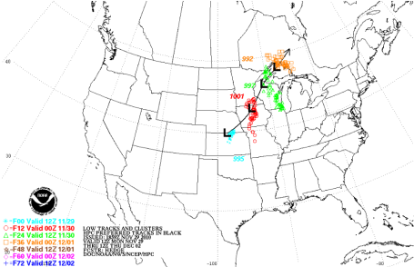
Storm Synopsis. Here's a good summary from the local Chanhassen National Weather Service Office, showing the projected storm track, with the heaviest snow bands setting up well north/west of the Twin Cities. Not sure we'll pick up 2-4", leaning more toward 1-2", but 3" amounts are possible far northern suburbs, closer to Princeton and Taylors Falls. Based on the latest guidance (and that surge of dry air overhead later tonight and Tuesday) I'm thinking closer to an inch or 2 for the immediate metro - best chance of 2" northern and west metro.
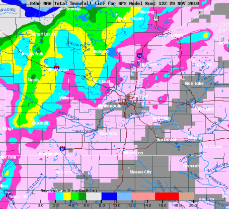
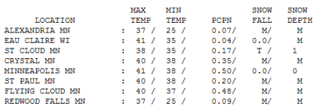
"Nuisance To Plowable." Although only 1-2" is expected in the immediate Twin Cities area (too warm yesterday for snow - too dry aloft today for significant accumulation), St. Cloud could wind up with 2-4", with 4-8" from Alexandria and Detroit Lakes to Bemidji - some counties in the Red River Valley may still pick up a cool 8-12" before the flakes stop falling late Tuesday.
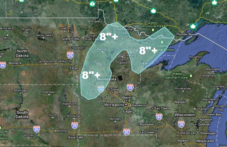
Heaviest Snow Potential. According to NOAA the western third (and roughly the northern half) of Minnesota may pick up as much as 6-8" or more of snow by Tuesday afternoon, the heaviest snow bands setting up 200 miles north/west of the storm track. Maps courtesy of Ham Weather.
Storm Track. The path of this latest storm was too far north/west for significant snow in the Twin Cities.
A "perfect" path usually follows a rough line from Des Moines to La Crosse, WI to Wausau. In this case a track 75-100 miles farther north/west pulled in enough warm air for rain much of Monday, a surge of dry air aloft (the "dry tongue") cutting off snowfall amounts over southeastern and east central MN and western WI by the time it's actually cold enough for snow in the lowest mile of the atmosphere. Yes, it's all about timing....
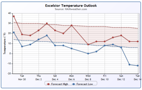
Meteogram. The future (15 day) temperature trend shows a definite cooling trend, with a few upward blips (highs come close to 30 this upcoming weekend, then tumble again after December 5. No more spells of Indian Summer in sight, I fear. Graph courtesy of Ham Weather, a division of WeatherNation.
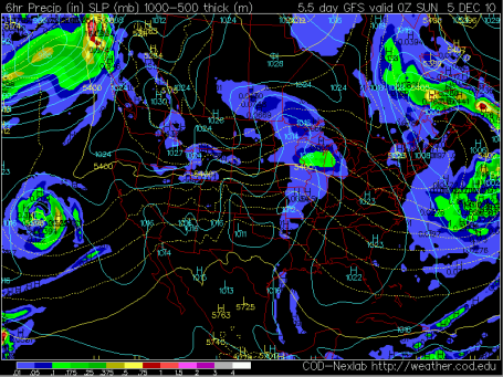
Saturday Flakes? Right now it doesn't look like much, but a fast-moving, clipper-like disturbance may kick up a quick coating to an inch of fluff Saturday as temperatures climb toward 30. The way this month is going that would qualify as a "warm front." Behind that clipper much colder air arrives early next week. By Monday, December 6, temperatures may not be able to climb out of the teens. The map above is the GFS outlook, valid Saturday evening, showing a streak of slightly heavier snow pushing across Wisconsin. Again, right now it does NOT look like a significant snowfall.
Spokane Washington: Already More Snow Than All Of Last Winter. According to Accu Weather meteorologist Kristina Pydynowski, the town of Spokane has already picked up nearly 21" of snow, 3 times more snow than average for a typical November - already more snow then fell all last winter. Uh oh. Details
here.
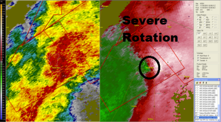
 Not Again
. Information was sketchy late last night, but another tornado may have struck near Yazoo City, MS. In late April 10 people died in Yazoo City after a 1.7 mile wide tornado swept into town with 150 mph+ winds. Here is the Doppler reflectivity and velocity fields corresponding with severe weather reports. Funny how Twitter is becoming the go-to site for severe weather information.
 Messy Monday Blues
. In the "warm sector" of an advancing storm south/southeast winds aloft lured the mercury above 40 in the Twin Cities, Rochester and Eau Claire. Had the mercury been 2-4 degrees colder (aloft) the Twin Cities would have picked up 2-5" of snow. As it was, .50" of rain had fallen as of 7pm Monday evening.
Paul's Conservation MN Outlook for the Twin Cities and all of Minnesota:
TODAY: Winter Weather Advisory (Warnings central/north/west). Periods of light snow and flurries, windy and colder. Wet/slushy roads will turn to ice. 1 - 2" metro. 4-8" far north/west MN. Turning colder as the day goes on.
7 am: 26 Light snow likely - icy roads.
Noon: 23 Windy with light snow and flurries, some blowing/drifting outside the metro.
5 pm: 21 Flurries, still gusty and cold.
TUESDAY NIGHT: Light snow tapers to flurries with little additional accumulation. Road will remain icy. Low: 10
WEDNESDAY: Sun returns, chilly start to December. High: 23
THURSDAY: Mix of clouds/sun - chilly. Good travel conditions. High: 22
FRIDAY: Clouds increase, probably dry. High: 24
SATURDAY: Light snow, coating - 1" possible. High: 31
SUNDAY: Cold wind, flurries linger. Little or no accumulation. high: 29
MONDAY: Sun returns, bitter cold. High: 19
Dreaded "Dry Tongue"
I know, it sounds like something out of a bad deli. Storms are complicated affairs; heavy snow requires a perfect balance of cold air and southern moisture. Too much of either ruins the recipe. But dry air inevitably gets tangled up into a mature storm; a surge of dusty air from the Desert Southwest that invariably cuts down on precipitation amounts. The latest models bring this dry surge right over the metro, meaning a "nuisance snow", maybe an inch or two. A waste of good moisture? Had it been 2-4 degrees colder Monday's half an inch of rain would have fallen as 3-5" snow in the Twin Cities. While the metro sees an inch or two, the farther north/west you travel, away from the metro, the worse conditions will be on the highways. Warnings are posted north/west of St. Cloud: some 4-8+" amounts are possible from Fergus Falls and Bemidji to the Duluth area.
We may dodge a snowy bullet here in the metro, but much of Minnesota will be transformed into a winter wonderland. A cold week is on tap, not as bitter as Thanksgiving. Temperatures run 10 degrees below average. A thaw is possible this upcoming weekend. After today's close encounter with snow I don't see any big stormy headaches looking out 7-10 days or so. A typical November brings 10" snow at MSP. We'll come close this year.
BroadcastWeather's Forecast Factory. Broadcast and Cable ran a
story about what we're doing for web sites, broadcasters and cable systems around the USA, focusing on a 24/7 local weather channel serving Kentucky, CN2, for Insight Communications in Louisville. All the content segments are produced in 3 HD studios in Excelsior, the video segments delivered to Kentucky via high-speed Internet. We can even go live during severe weather outbreaks with a latency, a delay, of about 2-3 seconds. We have 8 full-time meteorologists, the largest on-air weather team in Minnesota, and I'm grateful to all the on-air talent, developers and engineers who keep things rolling. I'm proud of my team, including the guys over at
Ham Weather who do a remarkable job with next-generation mapping and data, serving more than 850 clients around the world. BroadcastWeather is the brand we use for the cable market, just to clear up any possible confusion.
The End Of A Bizarre Hurricane Season. For the first time in recorded history, 12 hurricanes formed this year in the Atlantic basin without a single one making landfall in the United States, according to experts at Colorado State University. The six-month hurricane season officially ends Tuesday. "There was only a 2% or 3% chance of getting this many hurricanes and not having one hit the U.S.," says Gray. Tropical storms and hurricanes killed more than 250 people in the Caribbean and Central America this season, the Associated Press reported. The deadliest storms were Tropical Storm Matthew, Hurricane Tomas and Hurricane Alex. According to the National Hurricane Center in Miami, 19 named storms — tropical storms (which have sustained winds of at least 39 mph) and hurricanes (74 mph) — formed this year, including the 12 hurricanes. Five of the hurricanes were major, a Category 3 or higher, with wind speeds of at least 111 mph. Since 1944, only two other years had as many named storms: 1995 had 19 storms, and 2005 had 28. Just one tropical storm made U.S. landfall this year (Bonnie), according to the hurricane center. The USA has not had a hurricane make landfall since Hurricane Ike in 2008.
In addition, there was a 36-day period from Aug. 21 to Sept. 26 where there was not a single full day without at least one active tropical cyclone." AccuWeather.com: "Since the satellite era, there's never been a year when the western North Pacific has had fewer storms than the Atlantic basin has," Reeves said. "That's pretty remarkable." Sources: USA Today, Jeff Masters at Wunderblog and Accu-Weather.

. Yes, we see snow and cold fronts, but at least we don't have to worry about gangs of killer otters (do we?) Click
here to see the harrowing details - one more reason you may want to think twice before considering a move to Sarasota, Florida.


No comments:
Post a Comment