* Cold but dry through midday Friday with improving travel conditions.
* The sun should be out, temperatures average 10 degrees colder than normal for early December.
* Next chance of accumulating snow: late Friday into Sunday morning. Potentially plowable - heaviest amounts probably north of the Twin Cities.
* Temperatures moderate to near 30 Saturday, then fall again next week. No let-up in this cold spell through the first half of December. Yes, winter arrived early this year.
* Welcome to "
Meteorological Winter" by the way. If you look at the coldest 90 days of the year, on average - and who among us hasn't, winter really begins closer to December 1, not December 21. The calendar on the wall is misleading. As far as the atmosphere is concerned it's already winter. No kidding.
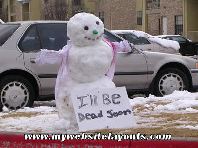
'Gotta Have My Latte! Not sure, but I think this image may have been Photoshopped. Just a hunch.
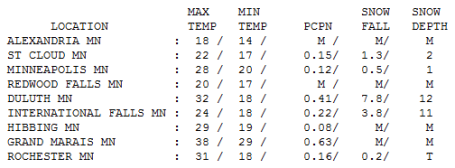
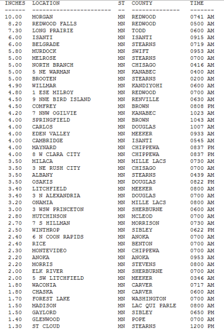
 Snowfall Totals
. The coveted
Golden Snow Shovel Award goes to Morgan (Redwood County), where 10" of snow fell. Isanti (far northern suburb of the Twin Cities) picked up a cool 6" of snow, nearly 5" in Willmar and 2.4" at Coon Rapids, nearly 2" at Chaska, 1.3" at St. Cloudd, while just down the road in Stearns County a healthy 6" fell at Belgrade. Source: National Weather Service - details
here.
 Brainerd Snow
. The Brainerd area picked up anywhere from 4-6" or more of snow - trails should be in pretty good shape next weekend (no chance of melting between now and Saturday). Click
here to get an eyeful of Brainerd snow via YouTube.
*
Truth In Advertising. With Doppler radar and supercomputers meteorologists (myself included) give the
illusion that we can predict snowfall amounts
down to the inch. People usually aren't interested in a range. "Paul, how many inches of snow will fall in MY yard?" It's a little like trying to predict which town will experience a tornado touchdown during the summer months. We can tell when conditions are ripe (for tornadoes or heavy snow) but trying to delineate precisely how many inches will fall in a specific town is beyond the capability of our technology. That's why we give ranges, and why I've tried to drive home the concept of snowstorm classifications: "nuisance", "plowable", and "crippling". Trying to anticipate, 24-48 hours in advance, where these small, micro-scale, 30 mile wide bands of intense snow will set up is wishful thinking. I just wanted to come clean and mention something that's been on my mind these last couple of storms. We do the best we can with what we have (radar, current observations and SCORES of different computer models) but there will always be challenges beyond the scope of the technology.
End of rant. Sorry about that.
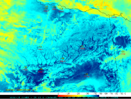
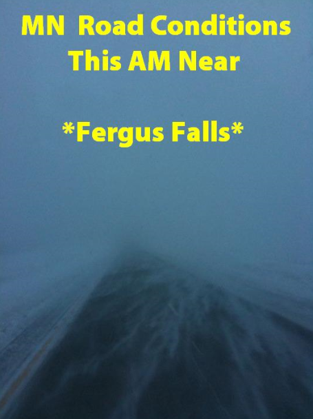
"White-Out". Conditions in Fergus Falls Tuesday morning. Thanks to Mike Hanna for passing along this example of "zero visibility conditions."
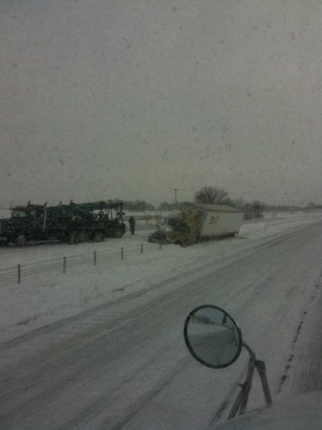
Rough Travel. Even large freight trucks had trouble navigating the snow, ice and wind on Tuesday, photo courtesy of Mike Hanna.
Saturday Snowfall? Although it doesn't look like a heavy accumulation right now, I wouldn't be surprised to see Saturday's fast-moving clipper system squeeze out a few inches in the Twin Cities, maybe 3-6" over parts of central and northern MN. Daytime temperatures may be close to 30 by Saturday, keeping interstates and freeways mostly-wet, but a "plowable" snowfall can't be ruled out, especially north of MSP.
Snowy Trends. The long-range models are hinting at enough snow to shovel and plow from Saturday into Sunday morning as a clipper-like system tracks across the Upper Midwest. It's still (way) too early to get specific with timing or amounts - but if you're traveling over the weekend you'll want to tune in for updates.
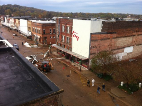
Late November Tornado Outbreak. This was the scene early Tuesday in downtown Yazoo City, Mississippi, after a series of tornadoes swept through the area, resulting in at least 7 injuries in a mobile home park outside of town. 32 businesses were damaged in downtown Yazoo City. The same city saw a massive 1.7 mile wide tornado in late April which left 10 people dead. More from USA Today
here.
Sweden Braces For Record Freeze. Stockholm is expecting some of the coldest temperatures in 100 years later this week. An excerpt from an
article in thelocal.se:
"Temperatures across the country are expected to drop to record lows for the first week of December, with the exception of the far north, with averages coming in 7-10 degrees Celsius below normal. Stockholm registered -11 degrees Celsius at the weekend, the coldest November temperature since 1965 and the mercury is set to plunge further on Wednesday and Thursday, dropping as low as -15. "It is far below average temperatures, which usually oscillate around zero at this time of the year," said Alexandra Ohlsson, a meteorologist with SMHI."
 First -40 Of The Winter Season
. Here we go - the first 40 below reading (Yukon Flats of Alaska). More (if you dare to look) from the CIMSS weather
blog at the University of Wisconsin.
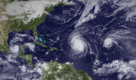
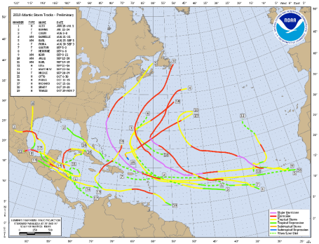
Extremely Active Hurricane Season Was A "Gentle Giant" For The USA. NOAA has a recap on what turned out to be a bizarre hurricane year for the Atlantic. 19 named storms, 12 hurricanes, and not one direct strike (tropical storms hit south Texas and Newfoundland, Canada) but the USA was exceedingly lucky in 2010. A few highlights of the NOAA
article: "According to NOAA the 2010 Atlantic hurricane season, which ends tomorrow, was one of the busiest on record. In contrast, the eastern North Pacific season had the fewest storms on record since the satellite era began. In the Atlantic Basin a total of 19 named storms formed – tied with 1887 and 1995 for third highest on record. Of those, 12 became hurricanes – tied with 1969 for second highest on record. Five of those reached major hurricane status of Category 3 or higher."
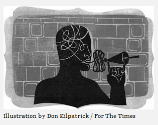
The Zuckerberg Revolution. Using Facebook, Twitter, and a dozen other social media to keep in touch with ever-more people, yet finding the substance of your posts and tweets a bit less satisfying? That's the subject of an interesting
article in the Los Angeles Times. "
We are so accustomed by now to declarations of new technological revolutions that another one hardly gets noticed, especially when it comes to finding new ways of minimizing how we communicate with each other. And it is entirely possible that this proposed geological change will be no more geological than all those other alleged game-changers. But whether his messaging system really transforms how people communicate or not, Zuckerberg issued what amounts to a manifesto that in its own terse way conveys what is already altering our lives — not only how we interact but also how we think and feel. It may even challenge the very idea of serious ideas. Call it Zuckerberg's Revolution."
 Swirling Snow
. Did you enjoy Tuesday's 30 mph winds and horizontal flakes? An acquired taste. The official high at MSP was 36 (shortly after midnight) but temperatures fell into the 20s during the day, the wind made it feel like single digits by afternoon. Highs ranged from 18 at Alexandria to 22 in St. Cloud and 31 at Rochester.
 Paul's Conservation MN Outlook for the Twin Cities and all of Minnesota:
TODAY: Winds ease, sun returns, 10-15 degrees colder than average. Winds: NW 10-20. High: 19
WEDNESDAY NIGHT: Mostly clear - good night for stargazing/and/or snuggling. Low: 9
THURSDAY: Mix of clouds and sun, chilly. High: 23
FRIDAY: Clouds increase, snow may arrive late? High: 24
SATURDAY: Few inches of snow possible, heavier amounts north of the metro. Travel may be impacted. High: near 30
SUNDAY: Snow tapers, better PM travel. High: 29
MONDAY: Partly sunny and brisk. high: 23
TUESDAY: Cold sun, feels like January. High: near 20 (holding in the teens outside the metro, single digit highs north?)
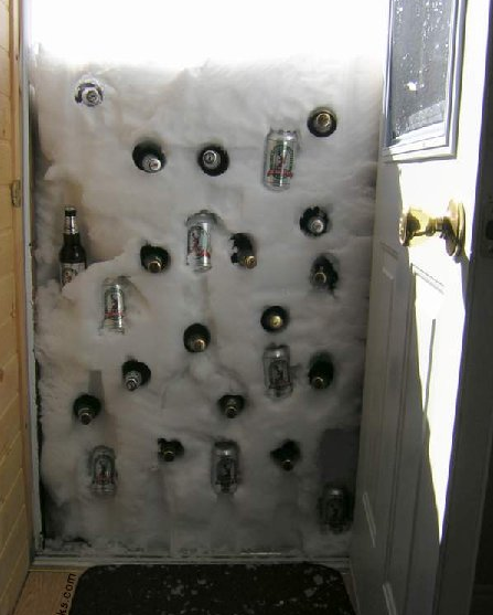
"Old Fashioned Minnesota Refrigerator"
Daydreaming 101
I married a good Italian girl; some of her (mild) Catholic guilt has rubbed off on me. I feel guilty for daydreaming of Sedona and Naples (Waikiki would be nice). I could never understand why the "snowbirds" fled south every year. I get it now. The older you get the more you dread the wicked winds of winter.
I can rationalize the snow (I love my snowmobiles!) but it's harder to suffer the outrageous slings and arrows of non-stop wind chill. Yes, the sun helps. Seeing friends (face to face, forget Facebook) helps. A good travel agent helps. But who among us has not had the urge to sweep the alarm clock off the bed stand, roll over and hibernate (until April). To quote Dan Rather, "courage".
Flakes give way to a little blue sky the next 3 days, temperatures 10 degrees colder than average. The next chance of accumulating snow? Saturday. A fast-moving, clipper-like storm may squeeze out a few inches of snow, heavier amounts north of MSP. It's too early to offer specific about timing or amounts. Click to the blog for a real-time narration of what various weather complications may pop up this weekend. Winter in Minnesota is a mental challenge. Stay positive. Quality of life!
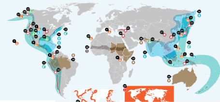 Natural Disaster "Hot Zones"
. You'll be relieved to hear that if you live in Minnesota (or anywhere in the Upper Midwest) you do not live in a hot zone. Yes it gets cold - yes we see an occasional tornado or flood, but there is a 3 to 5X greater risk of natural disasters on the west coast (earthquakes and brush fires) and the deep south and east coast (hurricanes, etc). How did this
site determine the zones of greatest risk? "
Most of the disasters we've highlighted here are caused by nature, and only occasionally helped along by humans. Arguably some of the storms are likely to be bigger due to climate changes that humans have had a hand in causing, and of course you wouldn't get famine without humans."
Global Climate Change Talks Begin In Cancun. On Monday talks got underway in Cancun, Mexico - representatives from countries around the world gathering to hammer out the framework for an agreement on limiting greenhouse gases. In light of last year's disappointing meeting in Copenhagen, expectations this year are low. The New York Times has more
here.
Global Temperatures Could Rise 4 Degrees C By 2060. From a recent
article at redorbit.com: "
Current methods being used to combat global warming simply aren't working, according to a series of papers published by the UK-based scientific academy The Royal Society. In fact, according to Telegraph Environmental Correspondent Louise Gray, researchers from Oxford University, the Tyndall Centre for Climate Change Research, and other prestigious academic institutions claim that global temperatures could rise by more than 4 degrees Celsius (7.2 degrees Fahrenheit) over the next 50 years. Unless worldwide emissions are drastically reduced by 2020, they say, severe flooding and droughts could result. In one of the papers, Tyndall Centre Director Kevin Anderson said that the only way to successfully reduce carbon emissions enough to prevent the drastic increase in temperatures is to halt economic growth in the world's wealthiest nations for the next 20 years."
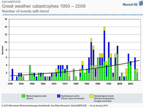
No Evidence Of Increasing Weather-Related Losses. From Roger Pielke Jr's blog, interesting news about extreme (global) weather events. The frequency and intensity of wild weather may be on the increase, but the author of a cited study finds no evidence of a parallel increase in monetary losses from these weather disasters. From the
blog: "
Independently of the method used,we find no significant upward trend in normalized disaster loss.This holds true whether we include all disasters or take out the ones unlikely to be affected by a changing climate. It also holds true if we step away from a global analysis and look at specific regions or step away from pooling all disaster types and look at specific types of disasters instead or combine these two sets of dis-aggregated analysis. Much caution is required in correctly interpreting these findings. What the results tell us is that, based on historical data, there is no evidence so far that climate change has increased the normalized economic loss from natural disasters."


No comments:
Post a Comment