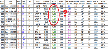
* Chance of a little very light snow today - dusting or coating possible (better chance south of the Twin Cities).
* No major storms in sight this week - next chance of any accumulation will be Sunday-Monday, when an inch or two can't be ruled out.
* Temperatures this week run a few degrees below average (normal high now is 40 at MSP)
* Next week: much colder: highs in the 20s and low 30s (potentially one of the colder Thanksgivings in recent memory).
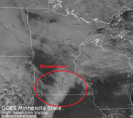
Snowy Stripe. Yesterday's visible satellite image (courtesy of WeatherTap, a subscription weather service) showed the 100 mile wind band of snow leftover from Saturday's fast-moving storm
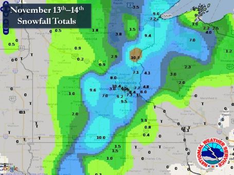
Snowfall Totals. What's remarkable about Saturday's storm: how narrow the band of heaviest ("plowable") amounts turned out to be: roughly 100 miles wide. No snow in Red Wing, less than an inch in St. Cloud, but a highly concentrated, focused swath of heavy snow straddling the metro area. More from the NWS
here.
From the Chanhassen office of the National Weather Service - a great recap of Saturday's freakish (100 mile wide) snow blitz:
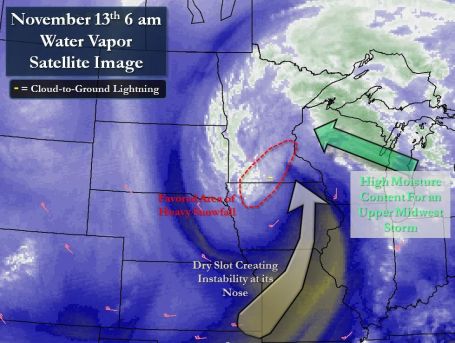
"Three days after a record high temperature of 68° in the Twin Cities, the weather turned around quite fiercely with the first winter storm of the season. A low pressure area moved from northern Missouri on the night of the 12th to western Wisconsin by the morning of the 14th. This was near to a classic path of what is called a "Panhandle Hooker" low pressure area for Minneapolis to receive at least six inches of snow. Snow would begin late the night of the 12th and persist through the day on the 13th for much of central and southern Minnesota into northwestern Wisconsin. As for near Eau Claire, snow changed to rain by daybreak Saturday morning, and the rain persisted for much of the day on Saturday. Precipitation of nearly two inches was observed during the weekend there. The snowfall rates across southern and eastern Minnesota were most explosive between 5 am and noon on the 13th. During that time window, lightning was observed across southern and eastern Minnesota into western Wisconsin with very heavy snowfall rates. Very high moisture content created a wet and heavy snowfall. While ground temperatures were warm and led to some melting, the heavy snowfall rates quickly overcame that. While snowfall began to taper Saturday evening, moisture wrapping around the low pressure area in Wisconsin helped to continue sporadic bursts of accumulating snow."
Event Climate Facts
-
8.0" was officially observed at the Minneapolis/St. Paul International Airport.
-
This was the largest pre-Thanksgiving, as well as November snowfall, for the Twin Cities since the "Halloween Blizzard" of October 31-November 2, 1991.
-
Since 1997, this was only the third six inch or greater official snowfall in the Twin Cities during meteorological autumn (Sept-Nov).
Dry Slots & Deformation Zones. Moisture wrapping all the way around Saturday's intense (pint-size) storm created a narrow swath of concentrated, sustained heavy snow from near Mankato to the Twin Cities to Duluth, what meteorologists lovingly refer to as a "deformation zone". West of this surge: precious little accumulation (.9" at St. Cloud). Just east of the heavy snow band a surge of dry, desert air (the "dry tongue") infiltrated the storm, cutting down amounts just south/east of St. Paul. All in all the models did a pretty good job with amounts - Friday's model runs also hinted (strongly) at all-snow, which turned out to be the case. Those monstrous Frisbee-size snowflakes were a tip-off that temperatures throughout the lowest mile of the atmosphere were close to freezing with plenty of supercooled water droplets providing the "glue" for these huge flakes.
"Snizzle" Potential. Although any significant storms will sail off to our south through the end of the week a lingering trough of low pressure, a wrinkle of cold air aloft, may set off a period of very light snow or flurries today - a dusting can't be ruled out, a light snowy drizzle possible, yes, a touch of "snizzle" - best chance south of the metro area.
 Southerly Clippers
. With prevailing jet stream winds howling from the northwest conditions won't be ripe for significant storms anytime soon. This week's clipper takes a track far enough south to spare Minnesota - Iowa may see a mix of snow/ice/rain by midweek.
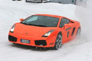
Great Car Advise: Winter Car Maintenance. I saw this
article and did a triple-take. Who in their right mind takes a 200k Lamborghini out into the snow and ice? Hardly a winter "beater". Saturday was a rude awakening for driving on snow and ice - the first storm is always a nail-biter as we all try to get back up to speed on winter driving. It's a good article with some very good advice.
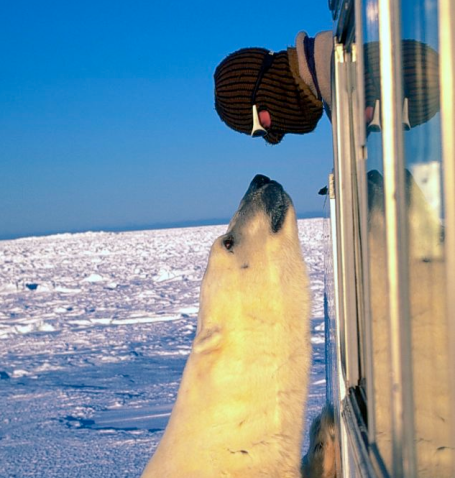
Face To Face With A Polar Bear. Under the heading: be careful what you wish for - a reporter had a very close (and potentially unpleasant) encounter with a curious (towering) polar bear near Cape Churchill, Canada. It all ended well, but it made for quite a story. Everything you ever wanted to know about polar bears (and more) is
here.
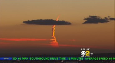
Contrail, Missile, Or Something Else? Controversey lingers over just what was in the western sky over Los Angeles the evening of November 4. A KCBS-TV photojournalist (same station that Paul Magers anchors the news) saw something striking in the western sky and started to roll video. It appeared to be the contrail of a missile (being fired toward the west, away from the city). Since then alleged experts have explained away the freakish sight as a jet contrail, although the photographer witnessed another jet contrail nearby and said there was "no comparison." The NY Times has a story
here - KCBS has the raw video
here. What do you think it was? Check out the comments section - a lot of conspiracy theories rolling around over this one.
Shelby, Ready To Fade To Black, Ponders Life Out Of The 'CCO Spotlight. If you missed Neal Justin's Sunday
story on the imminent retirement of Don Shelby, WCCO-TV Anchor Extraordinaire, it's worth a look. I'm a bit biased here, because Don is - and always will be - a dear friend. He's the last of the true "Rennaisance Men" (ice climber, bee keeper, poet and sculptor). he's also one of the smartest guys I've ever met (and not afraid to gently remind you of that fact). But Don has a huge heart; he volunteers his time to help scores of organizations - I've never seen him turn down a speaking request. Ever. His reasoning? People often get the wrong impression of
The Donald watching the tube - some people mistake passion and exuberance for arrogance - but when Don goes out and meets people, one on one, most people come away with an altogether different (and much more favorable) opinion of this super-smart, opinionated, white-haired sage. He's one of the last of a dying breed: a true journalist, with many prestigous awards under his belt. He's tolerates the anchor set but still prefers to get out into the field and report (especially about energy and sustainability, two subjects near and dear to his heart). Don suffered through a debilitating stroke a couple years ago but he came back, some nights barely able to get through a newscast. As I mention in the article, on a number of nights after he returned from his stroke I witnessed Don actually gripping the (spinning) anchor desk, trying to retain some semblance of control, all the sounds in the studio creating a noisy, confusing fog that made it nearly impossible to get a sentence out. Mr. Shelby (I have to call him that - it's in my contract) is truly one of a kind, and think what you will, but Minnesota is 'gonna miss this guy. That's my long-range prediction. BTW I'm heading into WCCO-TV one last time Wednesday night at 10 pm to do the weather with Don, tell him what life is like post-television, try to encourage him a little to keep his antenna up and be open to new opportunites that come out of left field - stuff he isn't even considering today. Two words: "Walmart Greeter".

. Now I've (officially) seen everything.
Here's a bold, new concept for delivering the weather. I wonder how long before this approach reaches the USA? Somehow I just can't see The Weather Channel going in this direction. One word: ratings.
Pre-Thanksgiving Snow? The approach of arctic air may set off a period of light snow next Wednesday-Thursday, the GFS model hinting at 1-3" of accumulation in time for Thanksgiving. I want to see a few more model runs - see if this is a fluke or whether there's any continuity from model to model. Too early to panic (I don't expect anything like last Saturday) but a couple inconvenient inches of snow may complicate Wednesday travel plans. The latter half of next week still looks cold, but not quite as Nanook as the models were hinting earlier today (850 mb temp drops to -12 C now - earlier the models were dropping temperatures down to -18). Indian Summer is nowhere to be found...
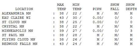
Cloud-Cluttered Monday. Yes, it felt chilly out there, but that's because temperatures last week at this time were 20-30 degrees warmer than average (remember that streak of 4 days above 60? Seems like a meteorological mirage). Monday's high was only 1 degree below average in the Twin Cities, 39, St. Cloud reported 38, which is average for November 15. 8" of snow fell Saturday at MSP International - that slushy pile is down to 3", the result of daytime highs above freezing AND unusually mild soil temperatures.
Paul's Conservation MN Outlook for the Twin Cities and all of Minnesota:
TUESDAY: Mostly cloudy, cooler than average. Winds: SW 5-10. High: 37
TUESDAY NIGHT: Patchy clouds - chilly. Low: 29
WEDNESDAY: Mostly gray (but quiet). High: 38
THURSDAY: Patchy blue sky, a bit colder. High: 34
FRIDAY: Mix of clouds and sun, stiff breeze. High: 38
SATURDAY: Better travel day of the weekend, clouds increase. High: 35
SUNDAY: Light snow possible, especially central and northern MN. Chance of a light accumulation. High: 34
MONDAY: Periods of light snow, light "nuisance" accumulation possible. High: 31
Cold Turkey
"The October Wind Storm of 2010 will go down in the record books as the strongest storm to ever hit Minnesota. The strong winds, heavy rain & blinding snow will leave a mark on people for years to come." Those are the words of 14 year old, "budding climatologist" Lucas Graunke, who writes an impressive monthly column for the Victoria Gazette. Stuff like that restores my faith in the future. It also reminds me of the early 70s, when I would cut out the daily weather map in the newspaper and scribble my own forecast next to it. Trial & error. And error & error.
There will be precious little to write about this week as storms detour south of Minnesota, clipping us with flurries, but no commute-crushing snow or ice. Enjoy our "not too cold" front, because arctic air may surge southward out of Canada the latter half of next week, sparking highs in teens & 20s - a fresh, invigorating blast of December. This may be one of the coldest Thanksgivings in modern history. Payback for a string of 60s last week?
One big silver lining: I don't see any major storms (rain/ice/snow) between now and the weekend after Thanksgiving. Cold air? Absolutely. But Old Man Winter may pull his punch a bit.
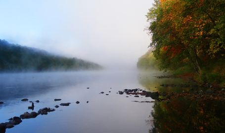
Fall Memories. Gizmodo.com and Flickr have posted a great resource for anyone with nostalgaic pangs for autumn - some of the most beautiful fall photos I've ever seen can be found
here.
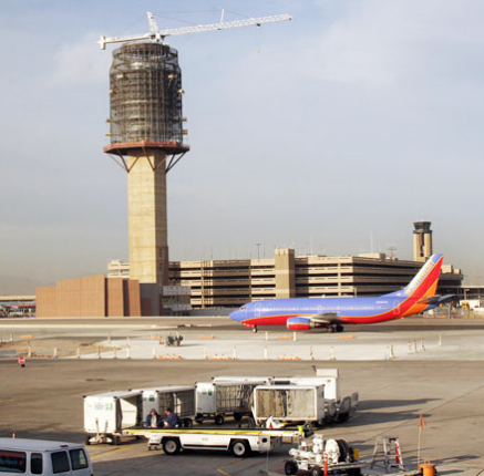
We Are #16! America' Airports - Ranked From First To Worst. O.K. This may be somewhat subjective, but it's possible to look at the data (average delays, number of cancellations, on-time arrivals & departures, etc) to come up with a pretty good idea about which airports are America's best. The Daily Beast came up with this
list. #1 on the list: Phoenix Sky Harbor Airport. At least we made the Top 20.
#16) MSP International Airport 2009 rank: 12th
On-time departures 2010: 79%
On-time arrivals 2010: 78%
On-time holiday departures: 81%
On-time holiday arrivals: 79%
Average security wait time: 9 minutes
Tarmac nightmares: 10th out of 27
Safety: 16th out of 27
Amenities: 2nd out of 27
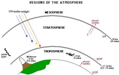
Review Of 4 Decades Of Scientific literature Concludes That Lower Atmosphere Is Warming. From a recent NOAA
report: "The troposphere, the lower part of the atmosphere closest to the Earth, is warming and this warming is broadly consistent with both theoretical expectations and climate models, according to a new scientific study that reviews the history of understanding of temperature changes and their causes in this key atmospheric layer."
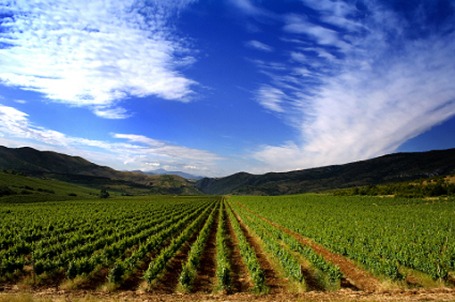
Firms Seek Patents On "Climate Ready" Altered Crops. From a 2008
story in the Washington Post: "A handful of the world's largest agricultural biotechnology companies are seeking hundreds of patents on gene-altered crops designed to withstand drought and other environmental stresses, part of a race for dominance in the potentially lucrative market for crops that can handle global warming, according to a report being released today. Three companies -- BASF of Germany, Syngenta of Switzerland and Monsanto of St. Louis -- have filed applications to control nearly two-thirds of the climate-related gene families submitted to patent offices worldwide, according to the report by the Ottawa-based ETC Group, an activist organization that advocates for subsistence farmers. The applications say that the new "climate ready" genes will help crops survive drought, flooding, saltwater incursions, high temperatures and increased ultraviolet radiation -- all of which are predicted to undermine food security in coming decades" It's probably only a matter of time before Minnesota's farmers take advantage of these new strains of corn, beans and wheat - better able to withstand weather extremes, more drought, floods and temperature extremes.

No comments:
Post a Comment