Unusual For First Half of November. With the exception of 1991 we haven't seen this much snow this early in the season in a long time. On average our first 1" of snowcover doesn't arrive until November 22. Ground temperatures are still relatively mild - that, coupled with highs in the upper 30s to near 40 means that MOST of the snow in your yard will probably be gone by Wednesday or Thursday. More from NOAA's National Snow Analyses site
here.
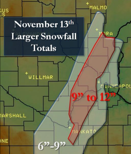
One Fickle Storm. I've said it before, but it bears repeating: every storm is different, with its own unique characteristics and eccentricities. Saturday's storm was exceptionally compact, laying down a narrow stripe of heavy snow. As expected the western metro picked up the heaviest amounts, a fairly consistent band of 9-12" from Le Sueur to Shakopee, Eden Prairie, Maple Grove, Champlin and Ham Lake. But just west of this snowy stripe precious little snow fell. St. Cloud picked up an INCH of snow, while 50 miles down the road Maple Grove boasted a foot. And you wonder why meteorologists are perpetually paranoid, nursing gray hairs and pet ulcers. Ugh.
Map courtesy of the local NWS office in Chanhassen.
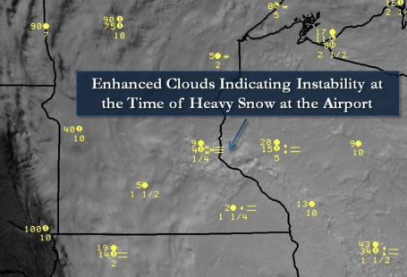
"Thunder-Snow" It's rare, but if the air is rising violently enough, snow can be accompanied by thunder and lightning. There were a few lightning strikes at the height of the storm Saturday morning, coinciding with snow falling at the rate of 2"/hour. Thunder-snow is most likely downwind of the Great Lakes, as arctic air passes over relatively mild lake water, creating extreme instability capable of snow "squalls" which can drop 2-5"/hour near Cleveland and Buffalo.
Quiet Week. So much for Indian Summer (and to think, last week at this time we were enjoying highs in the 60s - four days in a row above 60, to be exact). This week will definitely feel like November, a persistent trough of low pressure keeping us cloud-cluttered, chilly and unsettled through midweek (the NAM model is even hinting at a coating of light snow Tuesday morning). But the first chance of an inch or so of slush won't come until Saturday night and Sunday.
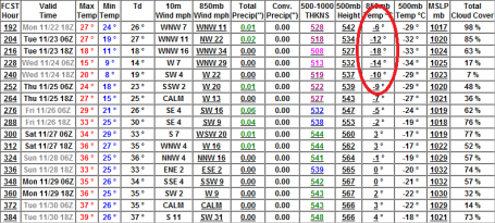
Dig Out The Coats. Forget about light jackets - next week at this time we'll be shivering in the 20s and low 30s, nighttime lows dipping into the teens. Temperatures at 850 mb (about 3,500 feet) dip down to -18 C, more like mid December air floating overhead. The good news: no significant snow is expected Thanksgiving week (models are hinting at a slushy inch or two the Friday & Saturday after Thanksgiving) as temperatures rise into the 30s. Hardly a warm front, but a litlte better than the start of next week, when I'm predicting a rerun of goosebumps.
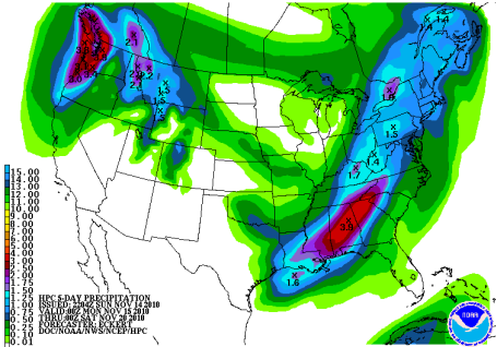
An Oasis Of Calm. Jet stream winds will whisk storms well south/east of Minnesota this week, the best chance of heavy rain over the Pacific northwest and the southeastern USA. The pattern isn't ripe for significant precipitation (of any flavor) looking out roughly 2 weeks. After that all bets are off.
Maryland Facility Is Nerve Center Of Nation's Weather Satellite System. A necklace of mini-van size (GOES) weather satellites 22,300 miles above the equator transmit a steady stream of data (500,000 transmissions/day!) down to a ground station at Wallops, Maryland, close to the National Weather Service central nerve center in Suitland, MD. Any time you see a satellite image or loop - it came via this link, established in 1966. An interesting overview on the GOES-system and how weather satellite data is processed is
here.
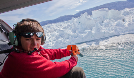
As Glaciers Melt, Science Seeks Data On Rising Seas. Sunday's New York Times had an excellent
story on what's happening in Greenland and Antarctica. The rate of melting has increased in recent years, and scientists are growing increasingly worried about the rate of change - far beyond what the supercomputer simulations were predicting. The truth: we're in uncharted waters when it comes to the turbulent changes taking place in the Arctic and Antarctic. A limited data set, and some of the satellites we rely on to monitor what's happening are going dark - not to be replaced anytime soon. The latest consensus: a sea level rise of at least 3 feet by the end of the century, which could threaten tens of millions of people living near sea level, including large portions of New Orleans, Florida and the Carolinas.
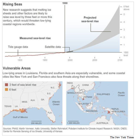
Rising Seas. As water warms, it increases in volume. Melting ice in the Arctic region doesn't add to sea level increases, but land-based melting over Greenland and Antarctica is a factor. As I tell my friends in Florida: don't buy any beachfront property. Buy something 3 blocks inland - and be patient.
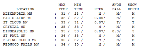
Gray Sunday. The day after the big (narrow) snow-blitz was murky and cloudy - a few flurries just to reminder you that it's still November (and Indian Summer is nowhere in sight). The 7.9" snow that fell in the Twin Cities officially shrank to 3" of slush on the ground by 7 pm yesterday. Highs ranged from 31 at Alexandia and 33 in St. Cloud to 35 in the Twin Cities, about 5 degrees cooler than average.
Paul's Conservation MN Outlook for the Twin Cities and all of Minnesota:
MONDAY: More clouds than sun, brisk. Winds: SW 7-12. High: 38
MONDAY NIGHT: Clouds increase - flurries possible late. Low: 27
TUESDAY: Mostly cloudy - a few passing flurries. High: 37
WEDNESDAY: Mostly cloudy, cool & damp. High: 39
THURSDAY: Fading sun, stiff breeze. High: 37
FRIDAY: Partly sunny, temperatures closer to "average". High: 41
SATURDAY: Clouds increase, late flurries? High: 38
SUNDAY: Periods of light snow, coating - 1" possible. High: 34
The Big Melt
"It figures, we finally get a big pile of snow and most of it melts before I can get outside and romp in it," a friend commented yesterday, disgusted at the (slushy/nasty) state of our snowpack. I feel your pain, but such are the perils of an early-season snowfall. Four days above 60 last week sealed our fate: on Friday soil temperatures were still in the mid 40s. In retrospect I'm amazed ANY snow actually stuck to the ground.
Every storm is different with its own meteorological baggage & eccentricities. Saturday's slushy blast was only 100 miles wide. Maple Grove got buried under a foot, while St. Cloud picks up an inch? And you wonder why meteorologists have gray hairs and pet ulcers.
Maybe it's an omen. On average MSP picks up its first inch of snow cover November 22. If you like snow it's an encouraging start; snow aficionados have had little to cheer about since 66" fell in 2003-2004.
We got our ration of excitement for the month. No more big, headline-grabbing storms are brewing through Thanksgiving. A chilly week is on tap, a few spits of snow every now and then (but no accumulation until next Sunday, when a slushy coating is possible). Turkey-day highs: 32-37 F.
Global Warming Could Lead To Vast Chocolate Shortage. "In 20 years chocolate will be like caviar. It will become so rare and so expensive that the average Joe just won't be able to afford it," according to one researcher quoted in a
story at alternet.org. Chocolate consumption is increasing faster than cocoa production, and the system is not sustainable, according to some analysts. OK. Climate change seems remote and faraway - impacting distant countries, but don't mess with my chocolate! A number of factors are involved in this precarious prediction - which we all hope is nothing more than hot air.
John Shimkus, Who Denies Climate Change on Religous Grounds, Could Lead House Environmental Policy. Click
here to read all about it. Call me crazy but God created us in his image, right? He gave us brains, the power of reason, he taught us to be accountable, that actions have consequences. Am I missing something here? I'm a Christian too - I believe we have a moral obligation to future generations, to our kids, and their kids. Ultimately the issue of climate change may be too polarizing, too much of a political litmus test, as ridiculous as it sounds to turn our backs on science and pin our future on ideology, dogma and wishful thinking.
Energy Security. In the end the ONLY thing that may unite Americans is the realization that a). we're addicted to oil and b). at some point cheap oil will run out - we better have a viable Plan B to ensure future growth and prosperity. Forget about climate change. Let's talk about energy security and energy independence. If we can wean ourselves off Saudi crude, stimulate millions of new (sustainable) jobs focused on renewable energy (and yes, nuclear probably needs to be part of the equation), and oh, by the way, clean up the air simultaneously, all the better. I have a hunch this is how the narrative is going to go. Make it less about climate change (and Al Gore) and more about how we're going to reinvent ourselves as a nation and avoid pinning future economic success on dwindling supplies of oil, natural gas and "clean" coal. Here's a scripture I quote which kind of sums it up for me:
"
Man has been appointed as a steward for the management of God's property, and ultimately he will give account for his stewardship." Luke 16:2


No comments:
Post a Comment