* Potential for a major Saturday snowstorm. Mostly rain east metro and southeastern MN, under 1-2" snow expected, but far west metro could wind up with 3-6" or more by Saturday night, maybe a band of 5-10"+ 30-70 miles west of the Twin Cities. Travel conditions will go downhill as the day goes on tomorrow - stay tuned for updates.
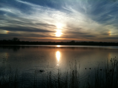
Sun Setting On Autumn. Thanks to WeatherNation meteorologist Bay Scroggins for snapping this photo of the sun setting over Lake Hiawatha, with a vivid "sun dog" visible to the right of the sun, caused by white sunlight being refracted (bent) through millions of tiny, prism-like ice crystals suspended 25,000 feet above the ground. Yes, it was an amazing autumn, a Super-sized Fall this year. But the sun is now as high in the sky as it was the last week of January. That has implications for our weather, as we're all about to discover within
36-48 hours.
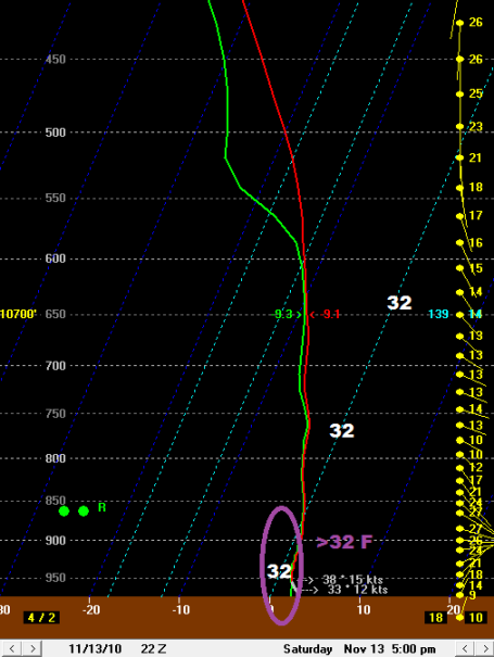
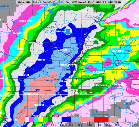
"Skew-T" Here is a cross-section of the atmosphere, valid 5 pm Saturday. The line going straight up is a "sounding", a temperature plot throughout the entire cross-section of the atmosphere above the Twin Cities. To get (all) snow temperatures have to be consistently below 32 F - even a thin layer of air warmer than 32 F. can trigger a changeover to rain. The models are hinting at wet snow mixing with rain late morning Saturday, but temperatures during the afternoon are forecast to warm (ever so slightly) - to just above 32 throughout the lowest 2,500 to 3,000 feet of the atmosphere - which SHOULD mean rain mixing in with the snow. Then again - it's a VERY close call and I'm nervous. The air overhead will be rising rapidly Saturday - which can cool the air, which could be just enough to tip precipitation over to (mostly) snow, especially western suburbs. Bottom line: we're right on the edge - and if the temperature winds up being 1-3 degrees colder overhead, much of the metro could wind up with 5-10" of snow.That is still a very distinct possibility (although I'm leaning more toward 1-2" east suburbs, 2-4" downtowns, with as much as 4-8" far western suburbs, from Chaska, Delano and Excelsior to Medina, Rockford, Elk River and the greater St. Cloud area. There could be a 10" difference in snowfall totals over the span of 50 miles.

Paul's Conservation MN Outlook for the Twin Cities and all of Minnesota:
TODAY: Gray, PM rain develops. Winds: NE 7-12. High: 43
FRIDAY NIGHT: Cold rain likely. Low: 33
SATURDAY: Rain gradually changes to wet snow (faster changeover west of the metro area). High: 38
SATURDAY NIGHT: Periods of wet snow, couple inches possible in the metro, maybe enough to shovel/plow just west of MSP (band of 5-10" still possible parts of central and south central MN). Low: 30
SUNDAY: Snowy (potentially slippery) start, then slow clearing. High: near 40
MONDAY: Intervals of sun, November-like. High: 41
TUESDAY: Clipper arrives, slushy mix late PM? High: 39
WEDNESDAY: Lingering flakes, cold wind. High: 38
THURSDAY: Cool sun, dry sky. High: 36
Our worst fear as meteorologists? #1). Forget to wear pants in front of the green-screen. #2). Miss the EF-4 tornado because you're home having dessert, and #3). Predicting flurries, only to wake up the next morning to a cool foot of flurries. That's why weather-droids (as a profession) tend to overpredict snow. We live in mortal fear of another Armistice Day Blizzard (weather guys in Chicago predicted flurries - we wound up with 18" flurries with 10 foot drifts).
I can't remember the last time when we didn't have to "worry" about a changeover from rain to snow - a "pure snowstorm", no unpleasant additives, like sleet or freezing rain. The bottom line: the closer the next storm tracks to home, the better the chance warmer air will get wrapped up into the circulation, tilting precipitation over to rain vs. snow. The farther east the storm tracks, deeper into central Wisconsin, the greater the odds we'll have enough cold air in place for mostly snow. Bottom line: the rain/snow line will set up VERY close to the Twin Cities Saturday, mostly rain for southeastern MN and the St. Croix Valley, the far west metro (west of Chaska and Medina) may see mostly snow. Some 5-10" snowfall amounts are possible from Mankato and Glencoe to Delano, Willmar, Monticello and St. Cloud. The farther west you travel tomorrow, the better the chance of snow.
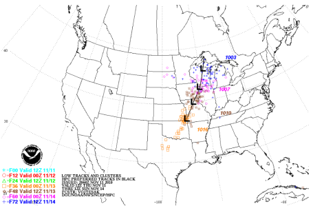
Tune in later today as we factor in the latest computer runs - I want to see if there are any trends, any consistency in how the models are nudging the storm track. The most accurate model: the NAM/WRF, is printing out close to 1.7" of liquid precipitation. if that were to all fall as snow we'd wind up with 13-18" of snow in the Twin Cities. I don't think that's going to happen. I think there will be some rain mixing in much of the day Saturday, especially from the downtowns on east toward Stillwater and Red Wing.
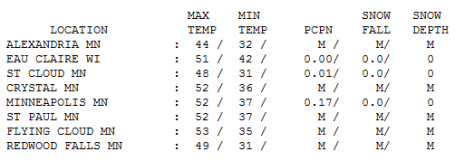
Travel conditions will get worse as the day goes on tomorrow. If you're thinking of driving to St. Cloud or Alexandria consider leaving later today, or maybe first thing tomorrow. The worst conditions will be after dark Saturday evening, as temperatures fall below 32 and wet/slushy roads become very icy. I do expect the NWS to issue Winter Storm Watches, possibly even Winter Storm Warnings by this evening. Stay tuned - we'll keep you posted with the very latest right here.
Slushy Possibilities
Rarely is a forecast ever black or white. It's usually some nebulous/frustrating shade of gray. So it is today: events are conspiring to dump a significant amount of snow on much of Minnesota; some towns could easily see a "plowable" snowfall of 5-10". The question: where will the heavy snow band set up? The most reliable model, the "NAM/WRF", keeps the lowest mile of the atmosphere above 32 F, hinting at a cold rain much of Saturday, maybe a couple of sloppy inches of slush at the tail-end of the storm Saturday night & early Sunday. Other models take the storm farther east, keeping us in the "cold sector", implying a faster changeover to snow. Ugh. Bottom line: confidence level is low. I want to see a few more model runs; see if there is continuity & consistency before going too far out on a (shaky) limb.
Right now the best chance of 5-10" comes from Mille Lacs & St. Cloud to Monticello, Willmar, even Mankato. A jog of just 50 miles in the storm track could make the difference between a cold rain & a cool half foot of slush. Time to stake the driveway and get serious about snow tires. Next week will feel like November; no mega-storms brewing for Thanksgiving week right now.

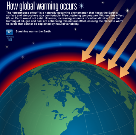
Rapid Warming Boosted Ancient Rainforest. From an interesting article at nature.com: "Most scientists have assumed that, as carbon dioxide levels increase and the Earth warms, plant species diversity in the rainforests will start to dwindle, with plants unable to adapt to the heat. But a new study suggests that the opposite may be true. In the past, rising atmospheric carbon dioxide and higher temperatures actually drove the evolution of far greater numbers of new rainforest plant species than were wiped out."

Climate Scientists Plan Campaign Against Global Warming Skeptics. From an article in the L.A. Times: "The American Geophysical Union plans to announce that 700 researchers have agreed to speak out on the issue. Other scientists plan a pushback against congressional conservatives who have vowed to kill the regulations on greenhouse gas emissions."

No comments:
Post a Comment