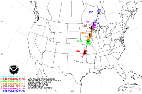
The trends: each run gets colder, taking the storm farther east (increasing the odds of heavy snow here in the metro). I don't see how we can avoid at least 5-6" slush, and if the deformation zone, the axis of heaviest snow sets up right over MSP? Some 8-12" amounts are likely then, in spite of initial melting as the snow hits the ground (which is still above freezing).
Bottom line: travel conditions will get worse as the day goes on. Interstates and major highways may be more wet than white, but after dark (5:30 pm) many wet roads will become slushy and icy. Getting to church Sunday morning may be an adventure (leave now and you'll show up on time).
Snow quickly tapers to flurries by Sunday afternoon, travel conditions slowly improve and by Monday's commute most roads should be in pretty good shape. Be careful out there today shoveling (high water content in the snow).
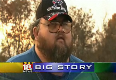
Today's blog has more on the snow, from every angle imaginable, just how unusual is a foot of snow before Thanksgiving (very), timely winter storm tips for your vehicle from the DNR & NWS, the fallacy of "cloud-seeding", an unusually snow-less October, water levels are dropping on Lake Michigan, and a guy in Kentucky with a beard...well...you just have to read the story.
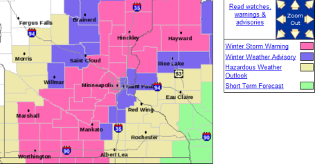
Storm Headlines
1). Winter Storm Warning means that hazardous winter travel conditions are imminent - travel will become increasingly difficult as the day goes on Saturday.
2). Odds of snow mixing with rain/sleet have lessened - enough cold air in place for mostly-snow. The only exception: far eastern suburbs of St. Paul, in the St. Croix River Valley, where a mixture of snow/sleet/rain may keep snowfall totals closer to 2-4".
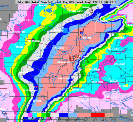
3). How much? Models print out 1.4", which would translate into 12-14" snow. I think there will be some melting as the snow hits lawns and fields (ground temperatures are near 40, and falling fast). This may shave a few inches off snow totals - I'm leaning toward 5-10" for the metro, closer to 8-12" far west metro, 3-6" around St. Paul, less to the east toward Stillwater and Cottage Grove, where 2-4" totals are expected.
4). Interstates/major highways may stay mostly wet much of today, but wet roads will become icy after dark (5:30 pm). Never tell a Minnesotan not to drive - but remember how crazy people get during the first snowfall of the season. It's like we all have a collective case of snowy-amnesia, we need a storm or 2 to get our snow-legs back.
5). Leave extra time to get to church tomorrow morning. Snow will slowly taper Sunday, little accumulation expected after lunch. Travel conditions should slowly improve Sunday afternoon - roads in pretty good shape for Monday's commute.
6). In all probability, based on data from Greg Spoden at the MN State Climate Office, this will probably be the biggest snowstorm for the Twin Cities since 1991, the year of the Halloween Superstorm.
The grim (humbling) reality? Every storm is different - in spite of scores of computer models we're still staring into the (meteorological) abyss every time we try to go out on a limb and predict "how many inches!" of snow will pile up. The final number depends on so many factors (some of which we can't even get a handle on):
1). Moist Fetch. Quantity of southern moisture entering Minnesota - duration of precipitation.
2). Speed of the storm - how fast is it moving, will it accelerate or possibly stall - how many hours will precipitaton fall?
3). Temperature profile throughout the lowest mile of the atmosphere - temperatures have to be below
32 F in the lowest mile - even a thin layer of (warmer) air can result in a changeover to rain/sleet - keeping final snowfall amounts down. Heavy snow is most favored when temperatures at 700 mb (about 10,000 feet above the ground) are close to -12 C, about 15-20 F - leading to the favor of dendritic crystals, a "perfect snow", not the slushy, mushy, messy snow that gunks up the yard (but is impossible to ski, snowboard or snowmobile on).
4). Ground temperature: right now it's in the low 40s - it will fall rapidly, but snow will almost certainly melt on contact for a time during the morning/midday hours.
5). Vertical Velocity: how rapidly is the air overhead rising? The stronger the upward motion, the greater the (potential) snowfall amounts. If the atmosphere is "critical" (close to freezing) violent upward motion can cool the layer enough to tip precipitation over from rain to snow. Another potential wrinkle in the weather-riddle.
How unusual is a big snowstorm before Thanksgiving? According to Greg Spoden at the Minnesota State Climatology Office:
"There have been no signficant pre-Thanksgiving snow events in the Twin Cities over the past decade. There were a few in the 1990's after the 1991 storm. See table below."
High Low Precip Snowfall Snow Depth
Year Month Day (F) (F) (in) (in)
1991 11 22 35 24 T T 0
1991 11 23 24 19 0.52 6.2 2
1991 11 24 21 12 T T 5
1992 11 1 42 33 0.57 2.5 M
1992 11 2 35 33 0.63 5.3 4
1992 11 3 34 32 0.22 1.2 6
1993 11 24 36 29 0.02 0.3 0
1993 11 25 33 20 0.45 4.3 2
1993 11 26 20 3 0.01 0.2 4
1996 11 20 25 22 0.46 4.4 4
1996 11 21 29 18 0.02 0.4 5
1996 11 22 28 15 0.12 1.0 5
1996 11 23 28 18 0.48 6.3 5
1996 11 24 19 -4 0.05 1.1 10
1997 11 11 28 18 0.04 0.5 0
1997 11 12 28 12 T T 0
1997 11 13 32 24 0.30 4.0 1
1997 11 14 35 28 0.08 1.0 4
1997 11 15 28 18 0.02 0.3 5
Bottom line: 1991 was a crazy winter. After the Halloween Superstorm we picked up another 6.2" on Nov. 23, 1991
During the 1990s we had 5 snowfalls of at least 4" before Thanksgiving, only 2 storms over 6". The last decade has been remarkable quiet and snow-free at MSP. That's what makes today's storm so unusual. Yes, this will probably be the biggest snowfall (pre-Thanksgiving) since 1991.
Preparations
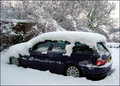
- Make sure your vehicle is ready for the season. Throughout the winter, keep your gas tank at least half-full to avoid gas line freeze
- Carry a winter storm survival kit. The typical kit should include a large coffee can with plastic lid. Inside the can, pack high energy foods, spare batteries for a flashlight, a red bandana or cloth to tie on the antenna, and candles/matches/metal cup to melt snow for drinking water.
- Other bulky or heavy items which should be in the vehicle include a shovel, jumper cables, a bag of sand or salt for traction, basic tools, blankets or sleeping bags, a tow cable or chain, a flashlight, a first aid kit, and extra clothing
- Consider keeping a cell phone. If you dial 911 from a cell phone, remember that the dispatcher will not know your location, so you must provide it to them. However, some new cell phones do have GPS capability.
- Before increasing your speed, get a feel for the traction. Remember that bridges and overpasses can be more slippery than other parts of the road. Do not brake suddenly. If you have anti-lock brakes, apply steady and firm pressure to the pedal. Do not pump anti-lock brakes
- If you begin to skid, remain calm. Ease your foot off of the gas and turn the wheel in the direction you want the front of the car to go
- When driving near snowplows, remember: Stay Back, Stay Alive. Reduce your speed. Never drive into a snow cloud. An average snowplow weighs 17 times more than an average car. If you are in a collision with a snowplow, you will lose. Be patient; follow eight seconds behind snowplows
- Check the latest weather information as you drive
- If severe winter weather is expected, consider postponing travel
- Avoid traveling alone during a winter storm
- Always fill the gas tank before entering open country, even for a short distance
- Stock your vehicle with a winter storm safety kit
- If the storm begins to be too much for you to handle, seek refuge
- Stay in your vehicle. Do not attempt to walk in a winter storm. You can easily become lost and disoriented in blowing and drifting snow. Staying in your car decreases your risk of frostbite and increases the chance of being rescued. make your vehicle visible to rescuers
- Beware of carbon monoxide. Run the engine a few minutes every hour, or every half hour in extreme cold. Keep one window slightly open. Make sure that snow does not block the exhaust pipe
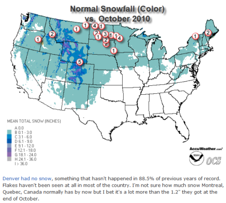
A Snowless October For Much of America. Accu-Weather reports on an unusual lack of snow across the lower 48 states last month. Denver had no snow - something which happens roughly 1 in 10 years. More from Jesse Farrell at WeatherMatrix here.

Cloud Seeding Not As Effective As Once Thought. An interesting article in Science Daily throws cold water on the notion that clouds can be "seeded" with silver iodide and frozen carbon dioxide to increase the likelihood of rain or snow downwind. Although no weather modification techniques have been attempted near Minnesota since the 1970s, cloud-seeding is fairly common in the western U.S. - especially winter cloud-seeding over the Sierra Nevada range - attempting to enhance snow which melts and provides drinking waters for cities from L.A. to Phoenix and Las Vegas.
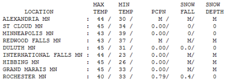
Friday Facts. It was the calm before the storm - you could almost feel it, smell the changes coming. We needed a buffer between Wednesday's record high of 68 F. (did that really happen) and a cool foot of snow for parts of the metro over the weekend. Good grief. Highs ranged from a raw 40 in Rochester (where .79" rain fell) to 43 in the Twin Cities, to 45 in St. Cloud, where the sun peeked through. Something for everyone.
Paul's Conservation MN Outlook for the Twin Cities and all of Minnesota:
TODAY: Winter Storm WARNING. Heavy snow, mixing with rain/sleet at times east of St. Paul. Wet interstates, secondary roads and side streets becoming increasingly slushy and slippery. Winds: N/NE 15-25. High: 34
SATURDAY NIGHT: More snow, heavy at times - wet roads become icy. Low: 29
SUNDAY: Snow slowly tapers, 5-10" totals close-in suburbs and downtowns, greater than 10" far west metro, but under 2-3" eastern suburbs of St. Paul. Travel conditions improve by afternoon. High: 38
MONDAY: Mostly cloudy, better travel statewide. High: near 40
TUESDAY: Clipper arrives with a few sprinkles/flurries - probably no accumulation. High: 42
WEDNESDAY: Cold wind, few flakes? High: 36
THURSDAY: Chilled sunlight - quiet and dry. High: 37
FRIDAY: Clouds increase - good travel conditions. High: 39
Probably "Plowable"
Only in Minnesota can you go from a record 68 F on a Wednesday to a cool foot of snow 72 hours later. Our weather is not for the faint of heart. This may come as a shock but meteorologists tend to over-predict snow. There, I said it. Why? We live in fear of forecasting "flurries", only to wake up the next day to a FOOT of flurries. Exhibit A: the Armistice Day Blizzard. The Mother of All Busted Forecasts. So you can usually take the inches flying around on local media, divide by 2, and that'll be closer to the truth. I've done that already, and still come up with 6-12" of slushy snow. Models print out nearly 2" of liquid precipitation. If that were to fall as all snow we'd pick up 15-20".
The models are trending colder each run; the track may yet bring enough warm air into town for a mix of snow, sleet & rain today. That said, MOST of the storm will probably fall as snow. Before the flakes subside Sunday afternoon some of the far western 'burbs may be digging out from under a foot or more. Welcome to autumn! Makes you wonder if we really might salvage a "real winter." La Nina winters tend to be colder & snowier. We'll see. Be careful out there - enjoy the new winter wonderland!
No comments:
Post a Comment