Weather Headlines
* Freezing Rain Advisory today for glaze ice during the morning hours.
* Coating of flurries possible Monday - good travel conditions overall.
* "Plowable" snowfall expected Wednesday, near white-out conditions possible outside the metro with treacherous travel and snow-covered freeways and interstates.
* Coldest Thanksgiving Day since 1985, when the high was 11 in the Twin Cities.
* No post-Thanksgiving storms in sight, getting home should be easier next weekend as temperatures recover into the 20s.
Icy Start. The NWS has issued a freezing rain advisory for east central MN and much of western WI for the morning hours Sunday as rain freezes on contact with cold surfaces. Front-wheel drive, AWD - nothing is going to make a difference on glaze ice (shy of a tank). The advisory expires at 9 am - roads should be mostly-wet after 10 or 11 am as temperatures approach the freezing mark.
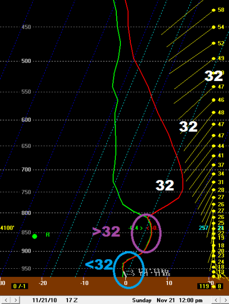
An Icy Sounding. Here is the "Skew-T" plot for noon today, a predicted vertical cross-section or thumbprint of the atmosphere, showing a layer of relatively mild air 2,000 to 4,000 feet above the ground (capable of changing snow over to rain). But a sub-freezing layer in the lowest few thousand feet of the atmosphere should mean a period of sleet (ice pellets) and even a few hours of freezing rain - rain freezing on contact with cold surfaces. Translation: roads may be very slippery during the morning hours, but an afternoon high in the mid 30s should insure mostly-wet roads after noon. Travel conditions will improve after lunchttime, but be extra-careful out there this morning. Front-wheel drive, AWD, NOTHING helps on glaze ice.
Potentially "Plowable" - "Crippling" Up North? You could have predicted this months ago. Of COURSE it's going to snow right before Thanksgiving, when people are driving, flying - everyone is scrambling (and braving the TSA gropes at airport security lines) to try to get home for Thanksgiving. Much can change between now and Wednesday, but the models have been fairly consistent bringing a burst of snow across Minnesota Wednesday - a very light, fluffy, powdery snow that should accumulate rapidly. It's early to be hurling around inch-amounts, but based on what I know now I don't think 4-8" of powder is an outrageous forecast, the GFS model is hinting at 6-12" for parts of central MN, as much as 15-20" of powder for northern MN. As I mention in today's column,
snow at 15 F. is MUCH more treacherous than snow falling at 30 F, when MnDOT chemicals do a quick and effective job melting snow, keeping most roads wet. If we really do see highs in the mid teens even the freeways will be snow-covered and very icy. Have a Plan B for Wednesday - at the very least leave PLENTY of extra time to get around town.
I have a hunch next Wednesday going to be a snowy, icy mess. Plowable for the metro, but potentially a crippling snow event up north, where blowing, drifting, and some 12-18"+ amounts could prolong the snow removal headaches into the end of the week. Hope I'm wrong with this one.
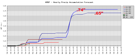
Here's what's keeping me up at night: if the snow/rain ratio really is 30/1 than .60" to .70" of predicted liquid could translate into closer to a foot, even 15" of snow close to home. I don't think that's inevitable, but it is a possibility, even close to the metro area by Thanksgiving. Gulp.
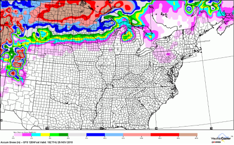
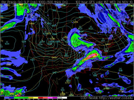
Near Blizzard Conditions By Midweek? Barometric pressure and precipitation amounts valid midday Wednesday. Not sure we'll have quite enough wind for a full-fledged blizzard, but the combination of light, powdery snow (prone to blowing and drifting) and bitterly cold temperatures will make for very treacherous travel conditions, especially Wednesday. Snow/rain ratios can reach 20/1, even 30/1 when it's this cold and dry - meaning a very light/fluffy snow - one that will be whipped around by 15-25 mph winds to produce near white-out conditions Wednesday, snow conceivably falling at the rate of 1-2"/hour, especially up north. It's still early to be talking specifics (timing and amounts) but I'm sufficiently impressed with Wednesday's impending "snow burst." Go ahead, take the rest of the week off, just to prepare. I'll write you a note. Me, I'm worried about picking up my son (home from the USNA for Thanksgiving) at MSP International (which is a zoo on a good day). I'm going to leave 3-4 times more time to get to, and home from the airport, due to the likelihood of snow-covered freeways.
I ran the Bufkit (GFS run) for Wednesday, which shows sustained winds > 30-35 mph only 1,000 to 3,000 feet above the ground. Some of that high-velocity air may reach the ground - producing near blizzard conditions Wednesday, especially over open areas of Minnesota outside the metro.
Midweek Snow Burst. Here's why I'm nervous - the latest two GFS runs confirm somewhere between .65 and .75" of liquid precipitation Wednesday, literally a short-event, 8-12 hour burst of snow as the leading edge of the coldest, arctic air pushes into Minnesota, literally wringing moisture out of our sky. Of course the atmosphere will be (plenty) cold enough for snow. The problem: between 28-32 F the snow/rain ratio is closer to 10/1 (meaning, 10" of snow for every inch of liquid precipitation). But when it's 10-15 F the snow/rain ratio may be closer to 20/1, maybe 30/1 over the Red River Valley, which produces much greater amounts of (light/powdery) snow - much easier to shovel, but FAR more prone to blowing, drifting and white-out conditions.
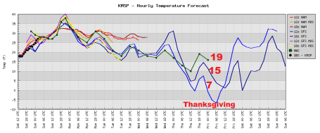
Going Cold Turkey. The amount of midweek snow is still very much up in the air - what is pretty much preordained is the fact that it's going to get REALLY cold later this week. Thanksgiving Day predicted highs range from 7 (too low) to 19 (too high). I'm hanging my hat on a Thursday high of 15, more than 20 degrees colder than average, probably the coldest Thanksgiving Day since 1989.
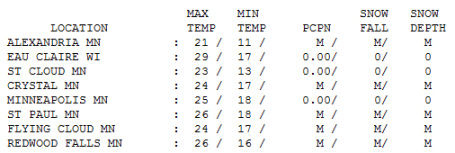
Colder Than Expected. A combination of a cold start + increasing clouds kept temperatures a few degrees colder than expected Saturday. That increases the potential for icing Sunday morning (ie. the ground is going to be sub-freezing through the late morning). Any rain that does fall will freeze on contact, producing potentially severe glaze ice for a time early today. Saturday highs ranged from 21 at Alexandria to 23 in St. Cloud, 25 in the Twin Cities and 26 at Redwood Falls.
Paul's Conservation MN Outlook for the Twin Cities and all of Minnesota:
SUNDAY: Freezing Rain Advisory AM Hours. Glaze ice, wet roads by PM. Winds: SE 8-13. High: 36
SUNDAY NIGHT: Mostly cloudy and damp. Low: 20
MONDAY: Colder, late coating of light snow/flurries. High: near 30
TUESDAY: Windy and noticeably colder with flurries (little accumulation expected). High: 24
WEDNESDAY: Travel Alert. Heavier snow likely, 3-6"+. Potential for a foot up north. High: 19 (wind chill closer to zero with near white-out conditions possible outside the metro).
THURSDAY: Icy sun returns, coldest Thanksgiving in 21 years? Low: 0. high: 16
FRIDAY: Patchy clouds, few flakes - no accumulation. Travel conditions slowly improve. High: 19
SATURDAY: Sun returns, good travel weather. High: 28
A "White" Thanksgiving
All snow storms are NOT created equal. Snow at 30 F. is easier to handle than snow falling at 15 F. Close to 32 F. MnDOT chemicals work quickly to keep main roads wet. When the mercury drops below roughly 20 F it becomes much more difficult to melt snow & ice - the combination of cold temperatures and traffic compacting the snow can create a treacherous layer of glaze ice. Even all wheel drive can't help.
I'm sticking with my prediction: the coldest Thanksgiving Day since '89, with highs in the mid teens. A "burst" of fluffy snow Wednesday will accumulate rapidly, "perfect powder" that will thrill skiers and winter weather enthusiasts. But travel Wednesday may become the vehicular equivalent of "Dawn of the Dead." I just have a hunch: 3-6" snow, even the freeways may be snow-covered & dangerous. Up north: 10-15"? Leave extra time to get around next week, especially Wednesday. If we see more than 4" this will be the snowiest Thanksgiving since '96, when we had 9" on the ground. Ugh. Why should anything be easy?
Today rain may freeze on contact (freezing rain). Expect wet roads by afternoon. Flurries are likely late Monday, but the "main event" arrives midweek. Great timing.
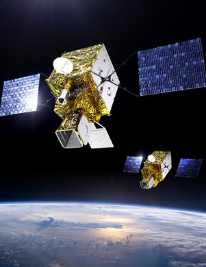
Weather Satellite Work Begins. The Europeans are getting ready to launch a third generation of weather satellites into orbit by 2018. These 2-ton, minivan-size high-tech marvels will not only be able to monitor weather conditions over Europe, but on-board "soundings" will send back detailed information about chemical compositions of specific layers of the atmosphere, critical to track greenhouse gas levels over time. More on the new generation of weather satellites from the BBC
here.
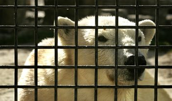
Polar Bear Habitat Takes Aim At Climate Change. The San Diego Zoo just invested $1 million renovatig its polar bear exhibit, the "Polar Bear Plunge" - to tell the story of climate change and what's happening to the polar bear population of the Arctic region. An interesting story from signonsandiego.com
here.
Study Suggests Climate Scientists Should Leave Out The Scary Parts. We're probably hard-wired deep in our DNA to avoid problems that seem intractable and unsolvable - stuff beyond any of our control. Nobody wants to hear that the sky is falling (or warming). The message may not seem as doom & gloom if it's accompanied by real-world solutions. According to researchers: "
They found that people who view the world as a fundamentally fair and stable place often choose to tune out threatening forecasts of the future. But those same people, if presented with positive solutions to global warming, tended to become less skeptical. [HealthCanal.com]. As Andrew Revkin points out in his Dot Earth blog the study "reinforces the case that a large part of the climate challenge is not out in the world of eroding glaciers and limited energy choices, but inside the human mind." The complete story is
here.
No comments:
Post a Comment