A few weather headlines:
1). The farther north you travel, the better the chance of significant snow amounts later this week.
2). The worst conditions will probably come from Wednesday afternoon through Thursday night.
3). Wednesday precipitation may start as a mix of rain/ice before changing over to mostly snow Wednesday PM hours.
* Snow may come in 2 distinct phases - the first shot of snow Wednesday afternoon/evening, then a brief break Wednesday night into early Thursday. Wrap-around moisture (called "backlash") approaching from the north may drop a couple more inches Thanksgiving Day, especially north of MSP.
4). A "plowable" accumulation is most likely north of the Twin Cities, but (depending on the final storm track) that zone of 3-6"+ snow could easily dip into the MSP metro area. Here in the metro I don't see how we see anything less than 3 or 4". If the storm tracks farther south - we could easily wind up in the 6-8" band, maybe more north metro.
5). If you leave Tuesday, or even first thing Wednesday, you should be able to get out in front of the storm.
6). Winds ease and flakes (finally) stop flying Friday - good news for power-shoppers. It's just going to be COLD, highs in the mid teens, after waking up to readings close to zero in the suburbs. Typical weather for late January. At least the sun will be out (as is often the case during the coldest days of winter). Oh yeah - it's still "autumn." Great.
7). I still don't see any post-Thanksgiving storms, getting home next weekend should be easier than traveling Wednesday-Thursday. By Sunday highs should be close to 32 F (which I guarantee will FEEL pretty good, after muddling through a couple of Nanook days Thursday and Friday).
8). If we have more than 4" on the ground by 7 pm Thursday (quite possible) this will be the snowiest Thanksgiving since 1996 (when MSP had 9" on the ground). By the way, 2003 was the year we had 4" reported on the ground Thanksgiving Day.
Mom Has A Bad Attitude. O.K. I begged her to hand me the remote after the third quarter of the Vikings game, but she insisted that "a turnaround is imminent! We can come back from this!" Right. So now I can't take her out in public anymore. Live and learn. I still love you mom - just remind me to never take you to the farmers market again (after a Vikings loss). Big mistake. (P.S. That's not my mom - just liked the photo, had to find a way to include it, especially in light of yesterday's maddening football fiasco at the dome).
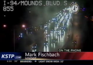
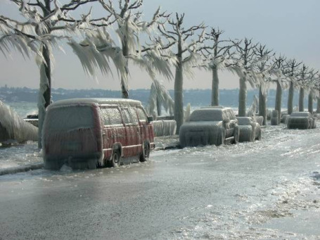
Worst Ice Storm In 29 Years? Hundreds of fender-benders, collisions and spin-outs late Saturday night and Sunday morning - not even AWD is going to save you when there's a thin film of glaze ice. One MnDOT official said it was the worst ice event he's witnessed in 29 years. KSTP has more details
here.
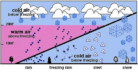
Atmospheric Profile for Ice. To get all snow the lowest mile or so of the atmosphere has to be below freezing. Even a shallow layer of > 32 F. air can trigger a changeover to rain. If those raindrops re-freeze before hitting the ground the result is "sleet" (ice pellets). Traction is poor but you can still get around. If there is a thicker layer of warm air aloft rain can reach the (cold) ground, freezing on contact into freezing rain, glaze ice. Not even front-wheel drive or all-wheel drive will make much of a difference on glaze ice.
Late Week Snow "Bursts". The latest GFS model is suggesting 3-6" of snow Wednesday into Thursday across the metro, with closer to 5-8" for St. Cloud, maybe a foot or more from Bemidji to Duluth. The timing and final amounts are still very much up in the air, but it still looks like a period of accumulating snow is likely from Wednesday into Thanksgiving Day.
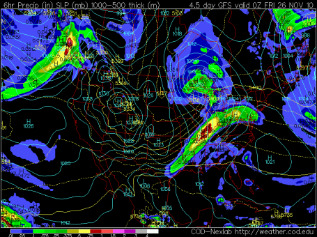
Near-Blizzard Conditions Up North Thanksgiving Day? This is the GFS forecast valid 6 pm Thanksgiving Day. I'm worried about the combination of falling/drifting snow + a strong pressure gradient across the state, capable of whipping up (sustained) winds of 25-35 mph, especially Thursday afternoon/evening. Moisture wrapping all the way around an intensifying storm over Lake Superior (approaching from the NORTH) - a phenomena known as "backlash" - may trigger a few extra inches of powder Thanksgiving Day, on top of the 3-6" that falls Wednesday PM hours and Wednesday night. Again, it's still too early to get specific about snow amounts - but I do expect a "plowable" accumulation from Wednesday afternoon into Thursday night.
The farther north you travel, closer to Brainerd, Grand Rapids or Duluth - the better the chance of 6-12" amounts (and near white-out conditions, especially Thursday).
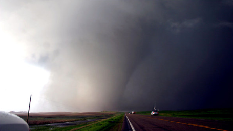
South Dakota's Blizzard Of Bad Weather. It's been a rough year in Minnesota (104 tornadoes) but the weather has been even more extreme just to our west. So far in 2010 South Dakota has seen 7 presidential disaster declarations. Everything from blizzards to EF-4 tornadoes to volley-ball size hail (a new national record back in June). What the heck is going on? The New York Times has a good summary
here.
"
The seven presidential disaster declarations issued here — part of a record 78 nationwide so far this year — more than doubled the number in any previous year, naming all but 10 of the 66 counties as a disaster area; some many times over. And after losing roads and power lines, watching homeowners displaced and crops drowned, the residents now speak with an exhausted fatalism, though rarely with complaint."
Is WIFI Making Trees "Sick"? A recent study by a Dutch university suggests that WIFI radiation can trigger strange abnormalities in trees. If it's doing that to the trees, wonder what it's doinng to us? More from Gizmodo
here.
The Attention Span Myth. Check out this
story from the New York Times (but first check your smart phone for recent texts, see what's on TV, while you're at it answer a few overdue e-mails). Attention span - what attention span? Is our collective attention span getting shorter and shorter (as ever more electronic distractions find their way into our over-stuffed lives?) or have we always been this hopeless distracted? A good question - one I'll consider when I get around to it.
Story Of My Life. Are there vitamins or supplements you can take to improve your memory? I keep rationalizing that "I have too much on my plate." That's why I can't remember stuff the way I could when I was a pup in my 20s. "Hey Paul, remember me? We met 23 years ago on a Tuesday when you gave a talk to the Kiwanis Club of West Ferndale!" Long pause. "You don't remember me? I came up and shook your hand?" Nope. Nothing. Na-da. That's why I've started saying "Nice to see you!" instead of "nice to meet you." So I don't celebrate my faulty memory. I highly recommend it.
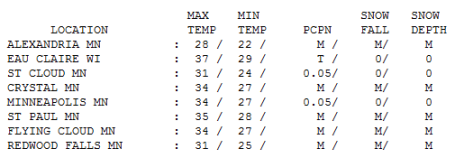
Icy Memories. Much of the .05" of rain that fell on the Twin Cities and St. Cloud froze on contact, "freezing rain" that created an insideous layer of glaze ice. Highs ranged from 28 at Alexandria to 31 in St. Cloud to 34 in the Twin Cities and 37 at Eau Claire, WI.
Paul's Conservation MN Outlook for the Twin Cities and all of Minnesota:
MONDAY: Colder, PM snow likely, around 1". Winds: NW 8-13. High: 28
MONDAY NIGHT: Light snow tapers to flurries - little additional accumulation. Low: 19
TUESDAY: Good travel day, few flakes - no problems getting around. High: 23
WEDNESDAY: Mix of rain/sleet/snow changes to all snow, 3-6" late? Travel gets worse as the day goes on. High: 28
THANKSGIVING DAY: Potential white-out up north? Few more inches, blowing & drifting. Afternoon High: 19
THURSDAY NIGHT: Snow finally tapers to flurries - still very poor travel conditions statewide. Low: 0
FRIDAY: Cold sun, less wind. Better travel. Risk fo shopping. High: 15
SATURDAY: Partly sunny, good shopping weather. Low: 9 High: 26
SUNDAY: No headaches getting home. More clouds than sun, closer to freezing. High: 31
The Perils of Ice
This is why many Minnesotans (especially older residents) fear winter. It's not the snow or even the debilitating cold. Ice is insidious, triggering far more broken bones/hips & other injuries than tornadoes, hurricanes and floods.
According to Professor Mark Seeley it may be a trend. His records show a 4-fold increase in ice storms (& mid-winter rain events) just since 2000. Nothing short of a Sherman tank is going to provide traction on the kind of glaze ice we experienced early Sunday, when hundreds of cars spun out. One MnDOT official said it was the worst ice storm he'd seen in 29 years.
Now comes the cold, capable of squeezing out a quick inch of snow today. Tuesday should be a good travel day, if you take off first thing Wednesday you may be able to stay ahead of the storm.
I still have a bad feeling about Wednesday & Thanksgiving Day as the core of the Arctic air arrives, a few "bursts" of powdery snow, at least 3-6" of powder, maybe a cool foot up north. Winds will whip up, sparking blowing/drifting; near-blizzard conditions are possible Thursday. Too early for specifics, but tune into my wx. blog for continuous updates. No post-Thanksgiving storms, thank God.
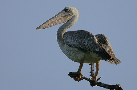
Confused African Pelicans Wind Up In Siberia. While we shiver through an unusually cold week across the Upper Midwest, Russia has been experiencing record warmth. Last Tuesday a flock of 7 pink African pelicans wound up in Siberia - a long way from home, according to Reuters. The story is
here.
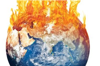
Unavoidable Climate Change - We've Reached The Point Of No Return. Peter Gleick argues that it may be too late to avoid some of the more dire symptoms of climate change. A recent study conducted by the Pacific Institute predicts significant impacts on the state of California and the west coast of the USA - more details
here.
*
Christian Earthkeeping - Social Justice Over Climate Change. There is a growing evangelical movement underway - people of all denominations realizing that climate change is not simply a scientific issue, but a moral one. A thoughtful article from christianpost.com is
here.
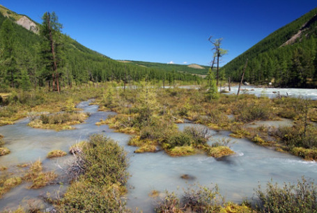
Leaking Siberian Ice Raises A Tricky Climate Issue. An estimated 1.5 TRILLION tons of carbon is locked up in frozen Siberian permafrost - scientists are increasingly concerned that the gradual thawing of permafrost and subsequent release of methane (23 times stronger than CO2) may become ground zero for climate change in the coming decades. From the AP
story: "
Katey Walter Anthony, of the University of Alaska Fairbanks, has been measuring methane seeps in Arctic lakes in Alaska, Canada and Russia, starting here around Chersky 10 years ago. She was stunned to see how much methane was leaking from holes in the sediment at the bottom of one of the first lakes she visited. "On some days it looked like the lake was boiling," she said. Returning each year, she noticed this and other lakes doubling in size as warm water ate into the frozen banks. "The edges of the lake look like someone eating a cookie. The permafrost gets digested in the guts of the lake and burps out as methane," she said in an interview in Amsterdam, the Netherlands, en route to a field trip in Greenland and Scandinavia. More than 50 billion tons could be unleashed from Siberian lakes alone, more than 10 times the amount now in the atmosphere, she said."


No comments:
Post a Comment