Conservation Minnesota Storm Headlines:
* Cold, dry start -
no problems getting into work/school/store this morning.
*
Freezing drizzle may arrive by midday - with temperatures around 28 around noon a few roads may become glazed with ice. Watch the bridges and secondary roads - major roads, interstates and freeways should remain mostly-wet.
* Sleet (ice pellets) changes to wet snow this afternoon, an inch or two by 6 pm.
Expect a slow PM commute. A winter weather advisory is in effect.
* Temperatures hold between 30-32 this afternoon -
wet freeways may become icy/snow-covered after 5 pm.
*
Snow totals range from 2-4" in the metro area - more north and east of the Twin Cities.
* Wet roads will become icy after 7 or 8 pm - a few inches of snow likely on top of the ice, making for very poor travel conditions tonight.
In general, the later in the day you travel, the worse the conditions will be on area highways.
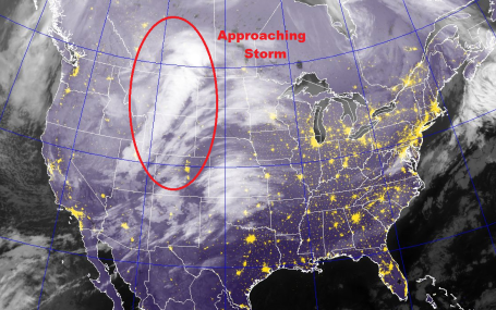
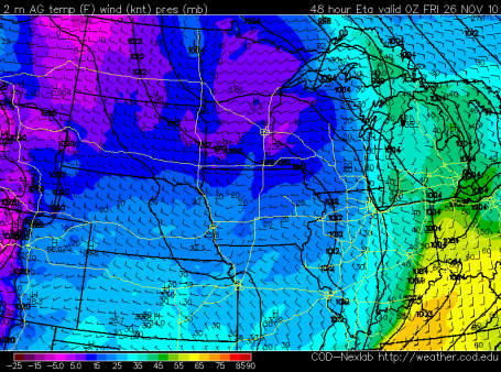
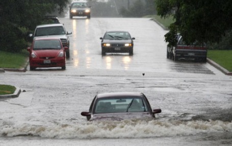
Here It Comes. No, it's not exactly Snow-Mageddon, but the comma-shaped swirl showing up on the infrared satellite image is a hint of trouble to come later today, a relatively brief, concentrated burst of snow (possibly spiked with a little ice). I still expect a "plowable" accumulation - enough to shovel, scrape and plow - treated freeways stay mostly-wet up until 4 pm or so - but most roads will become snow-covered after 6 or 7 pm, as temperatures fall rapidly through the 20s.
Snow Burst On Schedule. It's still coming - not the end of the world, just a 4-8 hour period of snow, maybe starting as a little ice (sleet and freezing rain). It still looks like the heaviest amounts come between 3 pm and 9 pm, give or take an hour or two. The morning commute won't be bad at all - the drive home later today may be a white-knuckle mess, especially on some of the side-streets and bridges outside the metro.
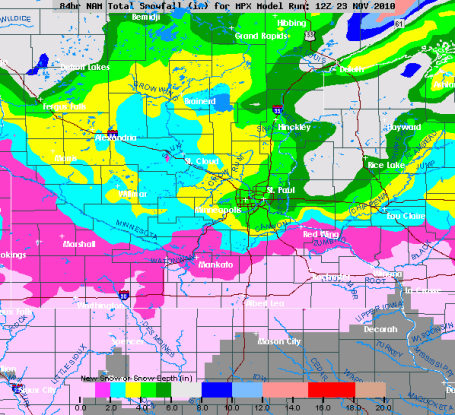
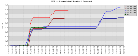
Expected Snowfall. The latest NAM model is predicting .35" liquid Wednesday afternoon and evening. A brief period of sleet/freezing rain is possible, but the lowest mile of the atmosphere should be colder than 32 F, cold enough for mostly-snow. Even discounting a couple of inches for an icy mix we could still wind up with 2-4" of snow. South and east of MSP it may be just warm enough for glaze ice (models are hinting at a tenth of an inch of glaze ice toward Owatonna, Rochester and Winona, where bridges and secondary roads may become treacherous by afternoon.
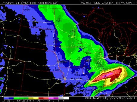
Convergence. The models are all converging on a solution of 2-4" of snow by tonight. The best chance of 3, 4, even 5" of icy snow will come over the northern/eastern suburbs of the Twin Cities. Models are still hinting at mostly snow - although precipitation may start as a little freezing drizzle (midday), mixing with sleet before changing to mostly snow during the afternoon hours. There may be 2-3" of new snow on the ground in time for PM rush hour. With temperatures rising into the 30-32 F. range I still believe (hope) that most freeways and interstates remain wet up until 4 or 5 pm. After dark temperatures start to drop off, and wet roads will become icy, then snow-covered.
You May Just Freeze Your Giblets Off. Check out the predicted temperature for 6 pm Thursday evening, a whopping 2 degrees in the metro area. That may be a little low, but certainly single digits - with a wind chill dipping to -10, maybe -15 F. I would resist the urge to camp out in front of your local Best Buy store for "Black Friday" specials - unless you want to flirt with frostbite. Is any digital plaything worth that?
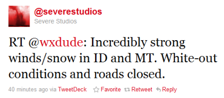
An Omen Of What's To Come? We've been tracking blizzard conditions from Seattle across the Rockies into the high plains. The definition of a blizzard: falling/blowing snow + sustained 35 mph winds + visibilities under 1/4 mile. We'll come close to that criteria by late afternoon/evening Wednesday, but I don't think we'll have to worry about a blizzard, in the classic sense.
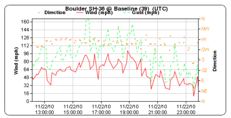
Wild Winds. Talk about a crazy "chinook" wind. On Sunday an automated D.O.T. weather system reported wind gusts to 166 mph. outside Boulder, Colorado. Accu-Weather's Jesse Ferrell has more details on the (crazy) weather gripping much of the Pacific Northwest - moving in our general direction -
here.
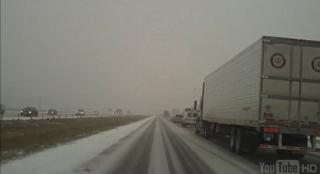
Slip Sliding Away. It was a harrowing drive on I-5 between Seattle and Bellingham, Washington yesterday, as captured on
this YouTube video. I hope this guy wasn't driving and filming simultaneously - in the snow and ice. Bad idea.
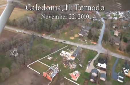
Monster Tornado. Shortly after 3 pm a half-mile wide tornado slammed into Caledonia, Illinois, leaving behind a trail of destruction and multiple injuries. The damage is extensive, as you can see in this YouTube video
clip. The BBC has more on the unusual late-season outbreak of severe weather in the Chicago area
here.
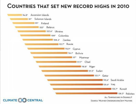
A Record Number of Records. According to Jeff Masters at
Wunderblog, 2010 brought a record number of all-time record highs around the world: 19 in all. He writes: "
The year 2010 now has the most national extreme heat records for a single year--nineteen. These nations comprise 20% of the total land area of Earth. This is the largest area of Earth's surface to experience all-time record high temperatures in any single year in the historical record. Looking back at the past decade, which was the hottest decade in the historical record, seventy-five counties set extreme hottest temperature records (33% of all countries.) For comparison, fifteen countries set extreme coldest temperature records over the past ten years (6% of all countries). My source for extreme weather records is the excellent book Extreme Weather by Chris Burt. His new updates (not yet published) remove a number of old disputed records. Keep in mind that the matter of determining extreme records is very difficult, and it is often a judgment call as to whether an old record is reliable or not. The World Meteorological Organization is currently in the process of contacting all nineteen of the nations I list here to see if the records can be officially verified."
Dreading Black Friday? SNL had a funny sketch about "Black Friday" madness. Check out the Hulu clip
here.
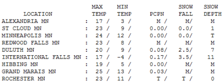
A Taste Of What's To Come. In spite of bright sun over much of central and southern MN temperatures only reached 17 at Alexandria, 23 in St. Cloud and 24 in the Twin Cities. 2.5" snow fell at Duluth, 3.5" at International Falls, where there is a healthy 11" on the ground - finally!
Paul's Conservation MN Outlook for the Twin Cities and all of Minnesota:
TODAY: Winter Weather Advisory. Freezing drizzle midday changing to snow during the afternoon - still looks like a slow PM commute. Winds: SE 15-30. High: 31
WEDNESDAY NIGHT: Periods of snow - most roads become snow-covered and icy. Low: 12
THANKSGIVING DAY: Flurries taper, coldest Thanksgiving since '89. High: 18 (wind chills near zero).
FRIDAY: Sun returns, unseasonably cold - early wind chill: -15. Low: 3. High: 23
SATURDAY: I can feel my fingers again! Dry and partly sunny - a good travel day. High: 32
SUNDAY: Clouds increase, milder. High: 36
MONDAY: 1-2" snow? Slick roads again. High: 33
TUESDAY: Leftover flurries, better travel. High: 28
Character-Building
Why should any of this be easy? The most heavily-traveled holiday of the year - let's throw a white-out into the mix and see what happens? The storm is still coming, followed by what may yet be the coldest Thanksgiving Day in 21 years. A few headlines: the earlier you travel today the better. Conditions will deteriorate this afternoon; the worst road conditions after dark, snow piling up on a thin layer of ice. Models print out 1/10th inch of ice south/east of the metro. This may turn into an ice storm for southeastern MN - watch the bridges and secondary roads by afternoon.
Sleet (ice pellets) may mix in at the start of the storm this afternoon, but MOST of the .50" of liquid precipitation at MSP will fall as snow. 3-5" may pile up, more north/east of the cities. Only the brave and foolish will be on the highways this evening and early tonight.
If you know of anyone thinking of camping out for "Black Friday" specials, try to talk them out of it. The wind chill early Friday will dip to -15. Good news: the sun stays out for power-shopping Friday, no big post-Thanksgiving storms brewing for the weekend. Only in Minnesota do the locals greet "freezing" with a relieved sigh.
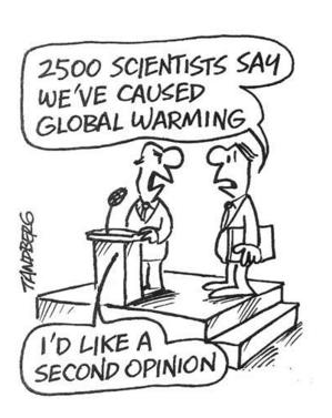
Climate: Be Afraid Of Global Warming. But Not Too Afraid. A follow-up
story in Time magazine tackles the subject of informing vs. scaring people into taking meaningful action. People tend to willfully tune out predictions that are dire. Maybe the deniers are right? Maybe it won't be that bad - after all, the scientists are still in disagreement, right? From the article: "
As green advocates and climate scientists alike debate how to counter the growing trend of doubt in global warming, the study is a useful reminder that the scariest messages can backfire, while media that focuses on potential solutions to climate change and energy can prove much more effective. Even if those solutions will be far from easy."
University of Dayton Researcher Predicts Increased Flooding, More Extreme Weather. Parts of Ohio may be especially vulnerable to extreme weather in the years ahead, according to a recent article. "
University of Dayton geology professor Shuang-Ye Wu’s research indicates that the potential for flooding on that scale is increasing as global warming accelerates. One hundred year floods could happen as frequently as every 35 years in a world warming as fast as scientists now estimate, her research shows. Parts of her studies on climate change are in the current issue of Hydrological Sciences Journal, an international science publication."
Leaking Siberian Ice Raises A Tricky Climate Issue. Yahoo News
reports on strange, unsettling events taking place on the (formerly) frozen permafrost of Siberian Russia. From the article: "
Katey Walter Anthony, of the University of Alaska Fairbanks, has been measuring methane seeps in Arctic lakes in Alaska, Canada and Russia, starting here around Chersky 10 years ago. She was stunned to see how much methane was leaking from holes in the sediment at the bottom of one of the first lakes she visited. "On some days it looked like the lake was boiling," she said. Returning each year, she noticed this and other lakes doubling in size as warm water ate into the frozen banks."
"The edges of the lake look like someone eating a cookie. The permafrost gets digested in the guts of the lake and burps out as methane," she said in an interview in Amsterdam, the Netherlands, en route to a field trip in Greenland and Scandinavia."
Life In The Hothouse: How A Living Planet Survives Climate Change. Author Melanie Lenart wrote a book focusing on how we might someday (soon) adapt to a warmer, stormier, more unpredictable environment. An excerpt from the
article: "
I also wrote it for people who want to go beyond global climate model projections. A close look at how the planet fared during past hothouses and warm periods makes it clear that we humans would face tremendous problems with even a slight warming, much less some of the numbers we are talking about for later this century. Forests might survive in many places they exist today, and perhaps even expand in others — but these changes still often involve fire and other die-offs along the way. Storms and hurricanes might help cool the warmest parts of the planet, but they still do tremendous damage when they strike cities. Heat waves, drought, floods that are off the charts, such as what we’ve seen in Pakistan and, for that matter, Rhode Island — these are the types of problems that come with changing climate."
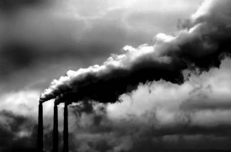
USA Emitted 20% of Global Warming Gases From 1750 To 2005. We are #1. We are #1. However, China is launching roughly 1 new coal-fired power plant ever WEEK, it's already overtaken the USA in terms of overall greenhouse gas emissions. Details
here.
Next Climate Warning Report Will Be Dramatically Worse: UN. From an AFP
article: "
He said UN Secretary General Ban Ki-moon would make it clear to world leaders in Cancun "that we should not take any comfort in the climate deniers' siren call." "The evidence shows us quite the opposite-- that we can't rest easy at all" as scientists agree that climate change "is happening in an accelerated way." "As preparations are underway for the next IPCC report, just about everything that you will see in the next report will be more dramatic than the last report, because that is where all the data is pointing." The next IPCC report is due in 2014 when thousands of climate scientists will gather to assess the state of the science and recommend actions to slow the rate of warming and subsequent climate disruption.

No comments:
Post a Comment