* No travel problems expected today. If you leave FIRST THING WEDNESDAY MORNING you should be able to stay out ahead of the storm.
* Heaviest snow (mixed with sleet, ice pellets) between 2 pm and 9 pm tomorrow.
* Expecting 3-6" in the metro area (best chance of 5 or 6" northern and eastern suburbs). The drive home tomorrow is going to be a MESS.
* Thursday should be the coldest Thanksgiving Day since 1989, when the "high" was 18.
* Wind chills dip into the -10 to -20 F. range Thursday night, down into the danger zone.
* No storms after Thanksgiving - getting home should be easier.
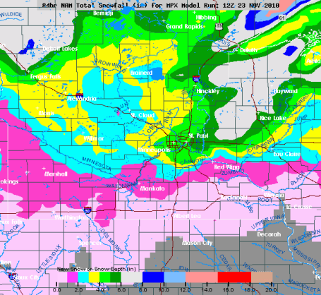
Probably "Plowable". the best chance of 4"+ amounts will come from the immediate Twin Cities north/east toward Hinckley and Rice Lake. St. Cloud is forecast to see less snow, maybe 2-4", with under 1" south of Mankato and Red Wing.
 Cold Enough For (Mostly) Snow
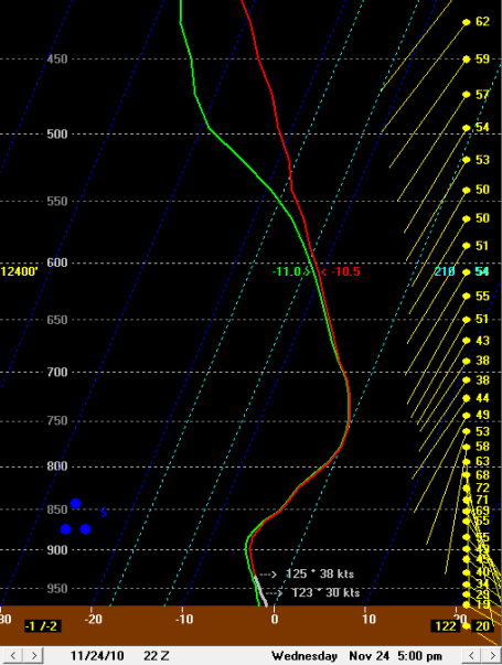
. The projected soundings suggest a little sleet mixing in Wednesday afternoon (especially south metro) but the lowest mile of the atmosphere should be cold enough for MOSTLY snow Wednesday PM hours. Winds are forecast to reach 40-70 mph in the lowest few thousand feet of the atmosphere - I'm still concerned about possible white-out, even blizzard conditions for a few hours tomorrow afternoon/evening.
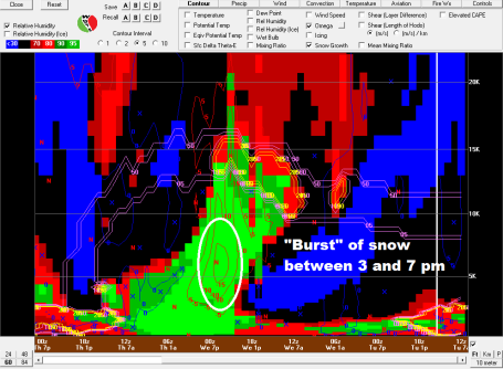
"Burst" Of Icy Snow? The latest NAM/WRF model is still hinting at rapidly rising air from mid afternoon into the evening hours tomorrow - a little sleet (ice pellets) may mix in, but precipitation should fall as mostly snow. 3-6" for the metro area, best chance of 5-6" north/east of MSP. Snow slowly tapers Wednesday night with little accumulation expected after midnight. Map courtesy of BUFKIT, a NWS product that helps meteorologists analyze future weather conditions.
No comments:
Post a Comment