* Good news for weekend shoppers and travelers: expect sun both days with temperatures thawing above freezing Sunday afternoon.
* No significant storms in sight through next weekend, but temperatures will cool down again by midweek.
* Arctic air may return between Dec. 6-10 (more in the blog below).
* Accumulating snow/slush possible as close as Des Moines, Chicago and Milwaukee by the end of next week.
* Painting mountains white to combat climate change? It's happening. More in the blog below...
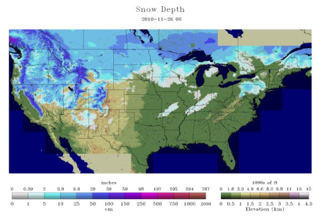
White Thanksgiving. According to NOAA's National Snow Analysis snow is on the ground across much of the western U.S. and the northern tier states. Most of New England has yet to see their first snowfall of the season. Click
here to see the very latest amounts nationwide.
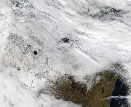
Snow From Space. The latest NASA "Modis" Terra satellite
image from 220 miles above the ground shows little snow across Wisconsin, as of midday Friday. Look carefully and you can see Lake Mille Lacs, even Lake Minnetonka, open water contrasted from fresh snow on the ground.
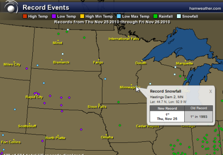
Record-Setting. Hastings tied a 24 hour snowfall record (1") on Thanksgiving Day, while Artichoke Lake, near the Dakota border, set a record cold high temperature of only 12 above. Who even knew there was an Artichoke Lake? Click on the interactive records for yourself on this Ham Weather
map. Ham weather is a subsidiary of WeatherNation.
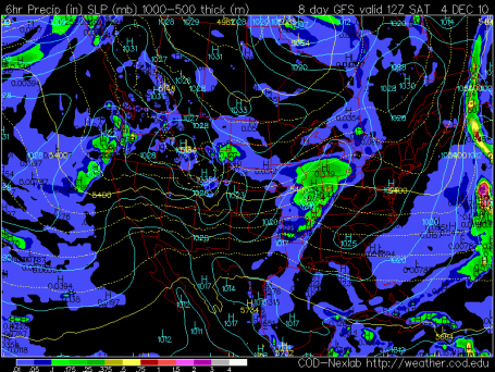
Good News For Thanksgiving Travelers. The models are all in reasonable agreement: no significant accumulations of snow or ice looking out through the end of next week. Getting home Sunday should be a relative breeze, lake effect near Buffalo and the U.P. of Michigan, but no organized, headline-generating storms anytime soon.
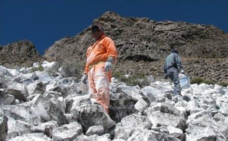
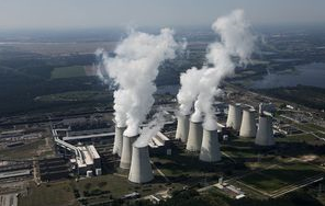
Inventor Paints Mountains White To Combat Climate Change. When I first stumbled upon this
story I thought it had to be something from the master of satire and irony, "The Onion." No such luck. The Daily Telegraph article documents the efforts of a small team to lessen the rate of glacier melt, one mountain at a time. All you need is a lot of white paint. "
By painting the mountains, Eduardo Gold hopes to replicate the effect of Andean glaciers, which reflect back sunlight and hence heat back through the atmosphere. The technique is scientifically plausible and, according to some scientists, may be the only method of lowering global temperatures in a crisis. "A white surface reflects the sun's rays back through the atmosphere and into space, in doing so it cools the area around it too," said the 55-year-old activist. "In effect in creates a micro-climate, so we can say that the cold generates more cold, just as heat generates more heat."
*
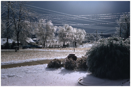
Record Ice. The November 20-21 ice storm that crippled much of Minnesota, resulting in hundreds of traffic accidents and untold injuries may have been the worst outbreak of ice since November 23, 1981, according to Pete Boulay at the MN State Climatology Office. More from Mark Seeley in his Minnesota WeatherTalk
blog.
 Chicago Slop-Storm?
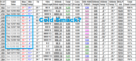
 The GFS computer run is hinting at a few inches of slushy, sloppy snow for Chicago and Detroit by Saturday morning of next week - in all probability this storm will pass off well south of Minnesota. No significant accumulation is in sight for the next 7-10 days.
 Another Smack?
 The 16-Day GFS model brings another Nanook airmass south of the border between Dec. 6 and Dec. 10, highs in the teens, nights in single digits to near zero. No tip-toeing into winter this year...
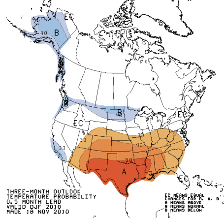
Long Long Range Outlook. Here is the 90 day outlook from
CPC, NOAA's Climate Prediction Center, calling for warmer than average weather for much of America from December through February, but a forecast of colder than average for North Dakota and the northern half of Minnesota. 2 of the 3 most recent La Nina events (cooling Pacific ocean water) were warmer than normal for much of the USA - La Nina winters tend to be considerably snowier than El Nino winters. Statistically the odds probably favor a closer-to-average winter in terms of snowfall, closer to 45-55" of snow. Maybe that's wishful thinking for a guy with a snowmobile - but the last time we saw above-average snowfall was the winter of 2003-2004, when 66" fell on the Twin Cities, much to the delight of snow-lovers. Since then it's been pretty boring. Yes, it's hard to keep the skiers and the commuters happy, simultaneously.
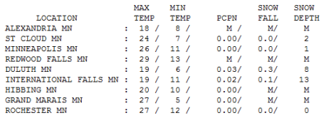
Breathing Easier. Under a sunny sky temperatures recovered nearly 10 degrees in most towns Friday. Highs ranged frm 18 at Alexandria to 24 in St. Cloud, 26 in the Twin Cities and 29 at Redwood Falls. International Falls boasts 13" on the ground, with 8" in Duluth.
Paul's Conservation MN Outlook for the Twin Cities and all of Minnesota:
TODAY: Not as numbing. Plenty of sun, a good day to play in the snow? Winds: SW 10. High: 28
SATURDAY NIGHT: A few clouds, not as cold. Low: 22
SUNDAY: Well-timed thaw. Sloppy (wet) roads - no trouble getting home. High: 37
MONDAY: Sprinkles and flurries. Wet roads. High: 34
TUESDAY: Mostly cloudy, windy and colder. High: 25
WEDNESDAY: Rare sunshine, still colder than normal. High: 26
THURSDAY: Clouds and temperatures increase. High: 32
FRIDAY: Flurries possible, no accumulation expected. High: 31
Getting Better
Flashbacks from the last few days: crawling on all fours to get across the street during Wednesday's ice storm - the worst since November 23, 1981, according to Pete Boulay at the State Climate Office...using a blow drier and a new (revolutionary) film from 3M to weatherproof my drafty, 1930s-era windows...wearing socks to bed...firing up the space heaters for added warmth. Ah, the memories.
Thanksgiving Day was, in fact, the coldest since 1985, but all that Arctic madness is behind us now. A "modified Pacific flow" aloft will tug the mercury into the upper 20s today, mid to upper 30s likely tomorrow. Sunday's outlook calls for dripping icicles.
Monday flurries usher colder air into Minnesota, but next week won't be nearly as Nanook as the previous 48 hours. The potential for accumulating snow Friday and Saturday has diminished - no weather drama in sight looking out 7-10 days. Temperatures run some 5-15 degrees below average through the first week of December, but nothing extreme is brewing as far ahead as I dare look out into the future (models have some minimal accuracy 2 weeks into the future). Beyond that consult your Grandma's bunionsand the trust Farmer's Almanac.
Experts Join Climate Debate. It seems that Minnesota is making (climate) news around the world. A war of words between John Abraham, an associate professor at the University of St. Thomas, and "Lord" Monckton, a well-known climate skeptic in the U.K. - has taken on international dimensions. According to Star Tribune reporter Josephine Marcotty, "
In October 2009 an internationally known climate change skeptic, Lord Christopher Monckton, gave a talk at Bethel University in Arden Hills that shocked Abraham into action. He spent months painstakingly crafting a point-by-point, fact-based rebuttal to Monckton's claims, then posted it on the faculty website. A blogger picked it up, then the British newspaper the Guardian published a story that inflamed cyberspace and unexpectedly put the small college's engineering department smack in the middle of a global Internet war. On news sites and blogs around he world, Abraham was either praised as a long-needed voice of reason or vilified for attacking Monckton, a British journalist, classics scholar and politician also known as 3rd Viscount Monckton of Brenchley, who had testified before Congress. The complete article is
here.
Front Line City In Virginia Tackles Rising Sea. The city of Norfolk, Virginia is trying to hold back rising sea levels, a 14" rise in just the last few decades, threatening coastal homes. The city has enlisted a Dutch firm to help with dams and possible levees, employing some of the techniques used in the Netherlands. More from the New York Times
here.
No "Bailout" For The Earth. Here is an excerpt from Johann Hart's
commentary in the "Independent." "
Why are the world’s governments bothering? Why are they jetting to Cancun next week to discuss what to do now about global warming? The vogue has passed. The fad has faded. Global warming is yesterday’s apocalypse. Didn’t somebody leak an email that showed it was all made up? Doesn’t it sometimes snow in the winter? Didn’t Al Gore get fat, or something? Alas, the biosphere doesn’t read Vogue. Nobody thought to tell it that global warming is so 2007. All it knows is three facts. 2010 is globally the hottest year since records began. 2010 is the year humanity’s emissions of planet-warming gases reached its highest level ever. And exactly as the climate scientists predicted, we are seeing a rapid increase in catastrophic weather events, from the choking of Moscow by gigantic unprecedented forest fires to the drowning of one quarter of Pakistan"
Cloud Modeling Suggests Greater Global Warming. From an
article in the U.K's Independent newspaper: "
A new paper published in the Journal of Climate has shone the light on the inefficiency that currently exists in the modelling of clouds in climate models. The authors of the paper presented a new approach that will help in understanding the clouds role in and their response to global warming. “All the global climate models we analyzed have serious deficiencies in simulating the properties of clouds in present-day climate,” noted lead author Axel Lauer at the International Pacific Research Center (IPRC) at UHM. “It is unfortunate that the global models’ greatest weakness may be in the one aspect that is most critical for predicting the magnitude of global warming.”
No comments:
Post a Comment