This is what NOT to do Saturday morning, a cautionary tale. Good luck out there.

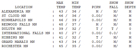
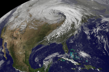 Anatomy Of A Superstorm. The National Weather Service office has done a fantastic job of summarizing last week's extreme low pressure "bomb" that spun up over northern Minnesota, producing an incredible central barometric pressure of 28.21", roughly equivalent to a Category 3 hurricane. Winds gusted as high as 63 mph across the state, downing trees and powerlines, knocking out power to thousands of local residents. A comprehensive summary of this record-setting low pressure system is here.
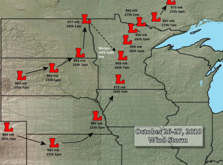 Timeline. Here is the chronology of last Tuesday's super-storm, courtesy of the National Weather Service.
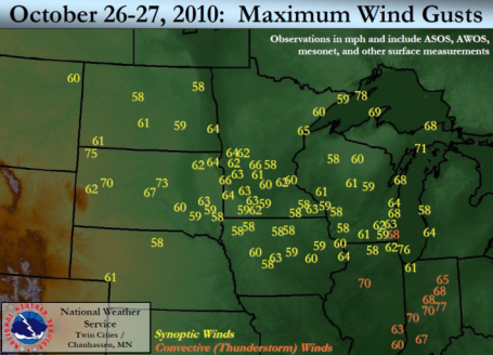 The Definition Of A Bad Hair Day. Here are the wind gusts from last Tuesday's "Landicane". Of course this storm in no way resembled a hurricane, which is a "warm-core" storm that gets energy from warm ocean water, translating warm water into thunderstorms which drop the air pressure, pulling more moisture into the center of the storm, which produces more T-storms, lowering the air pressure even more, a vicious cycle that only relents once the storm passes over land, where it's robbed of moisture and subsequently weakens. Last week's wild storm got it's energy from a large north-south contrast in temperature and a powerful Pacific "jet streak", a surge of high-velocity air embedded in the jet stream winds 4-8 miles above the ground, producing a temporary partial vacuum over northern Minnesota, setting up an extreme contrast in air pressure that caused 60 mph. winds to accelerate into the center of this "low". It was, in all probability, the strongest storm ever observed between the Rockies and the Appalacians.
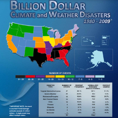
Billion Dollar Disasters. Don't let anyone from Texas, Tennessee or North Carolina give you a hard time about living in Minnesota. According to the NCDC, The National Climatic Data Center, those states (black above) have seen nearly 3 times more billion dollar weather disasters since 1980. The lowest risk: the Great Lakes states and interior New England. More from NCDC here.
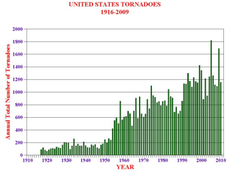
Tornado Trends. Data from SPC shows a steady increase in tornado touchdowns since 1920. However, you have to remember that tornadoes were VASTLY underreported before 1953. We just didn't have the trained network of SKYWARN spotters able to confirm tornado sightings. How much of the increase can be attributed to more tornadoes vs. more people out LOOKING for tornadoes is another question altogether. Data courtesy of the University of Nebraska at Lincoln, more details here.
Snow In Tennessee? This photo was taken Thursday morning on the highest terrain of Mt. LaConte, in far eastern Tennessee, where a few inches of snow piled up from the major storm soaking much of the eastern seaboard. Kind of ironic that eastern Tennessee has seen accumulating snow before most of Minnesota.
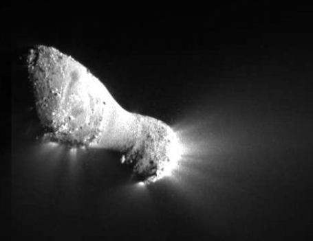
Close Encounter With A Comet. From an article at Spaceweather.com:
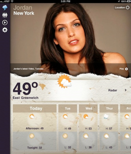
"Real Weather Girls". Why didn't I think of this? If you like weather, coupled with a dash of reality TV, all delivered by wholesome (?) women who seem to truly care about the weather around the world, consider this app for your iPad. Or not. Quoting from the story, "Real Weather Girls shows you all of the weather you can handle, but does it by featuring a specific girl for each city around the globe. So far there are 12 girls to choose from, with 12 locations being highlighted. In addition to giving you the weather, each girl has a specialty that she will share details on as the days unfold. It’s like reality TV with the weather as the baseline." Thanks to ZDNET.com for passing this along.
Paul's Conservation MN Outlook for the Twin Cities and all of Minnesota:
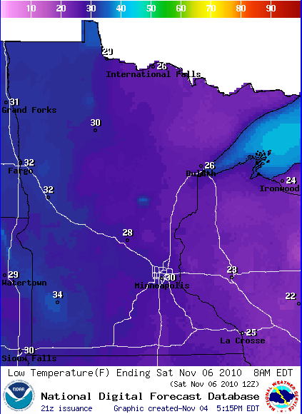
TODAY: Bright sun, less wind. NW 8-13. High: 44
FRIDAY NIGHT: Clear and chilly. Low: 30
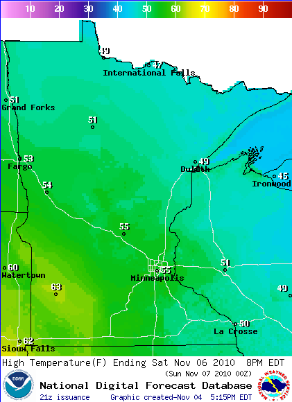
SATURDAY: Plenty of sun, light winds, nervous deer. Winds: SW 10-15. High: 56
SUNDAY: Lot's of sun, like mid October! Winds: E 5-10. High: 58
MONDAY: Taste of Indian Summer. Some sunshine through high clouds. High: near 60
TUESDAY: More clouds, drizzle possible later in the day? High: 54
WEDNESDAY: Unsettled, few showers possible (especially central/northern MN). High: 49
THURSDAY: Mostly cloudy, closer to average for this time of year. High: 46
Not bad for November
Lately I've felt a little like Snooki at a Mensa banquet. Minnesota meteorologists are all a bit BAFFLED by this pattern: week after week of atmospheric tranquility, interrupted by an occasional record-setting storm. With the exception of 2007 October was the warmest in 45 years. The last time it snowed at least an inch at MSP? February 27.
The potential for significant rain or snow next week has diminished (a better chance of rain turning to slush for Madison & Chicago). Long-range (GFS) models bring a real arctic front into town after Nov. 19, highs may hold in the 20s & 30s with a stinging wind chill. But no real "weather" is shaping up through next week.
Winds ease up today as a bubble of high pressure over Minnesota (look for a big blue "H" drifting above your house later today). Blue sky spills into the weekend, a brisk, dry start for the Deer Hunting Opener Saturday. Heavy jackets suggested: upper 40s north to mid 50s metro area. A hint of Indian Summer returns early next week - 60 is not out of the question by Monday.
An average November brings 10" snow to MSP. But since 2004 average Nov. snowfall in the metro has been 1.75". Our "Incredible Shrinking Winters."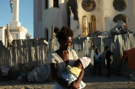 Storm Threatens Fragile Haiti. A massive earthquake struck Haiti just 10 months ago, over a million people still live outdoors, under tarps and in tents - at the mercy of the elements. All week officials have been keeping a nervous eye on "Tomas" - which now appears to be tracking just west of Port Au Prince, where Hurricanne Warnings are posted. It will be a very close call. The story from USA Today is here.
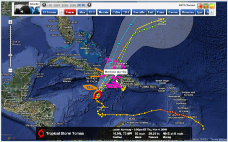 Hurricane Warnings Posted For Haiti. As of late Thursday night Tropical Storm Tomas was packing 60 mph sustained winds. Of greater concern - the storm is moving slowly, capable of 5-10" rains and serious flash flooding. Jamaica will be brushed by the storm - prevailing westerly winds aloft should nudge Tomas away from Florida and the east coast of the USA. Map courtesy of NHC and Ham Weather.
 No Ordinary Flight. What's it like to fly into the "eye" of a 125 mph. hurricane? NOAA Corp Commander Carl Newman describes what it's like to be at the controls of a "hurricane hunter" aircraft, the WP-3D aircraft sturdy enough to survive the flight into the core of a raging hurricane. Why do they do it? Weather satellites can only provide so much data about location and intensity. To determine whether the storm is intensifying or weakening it's necessary to fly INTO these storms, in fact a typical mission involves multiple passes into the eye, an "X-pattern" through the storm, probing the wind, temperature and humidity fields from different angles, flying at an altitude of 10,000 feet, gathering real-time data, and sending small weather instruments, called "dropsondes" into the storm that send back a steady stream of current data before reaching the ocean surface below. By the way, the USA is the only nation on Earth that flies into hurricanes. The story from NOAA is here.
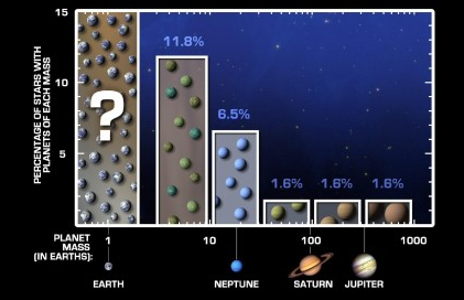 Earth-Size Planets Could Be Common, According To NASA Study. Our Milky Way galaxy, composed of 200 billion stars (give or take) may have as many as 46 billion Earth-size planets, according to a recent NASA analysis. The full read from Gizmag.com iis here.
Global Warming - The PC Game? "Fate of the World" is a global strategy game that puts our future in your hands. Decide how the world will respond to rising temperatures, heaving populations, dwindling resources, crumbling ecosystems and brave opportunities. Sounds like a lot of fun, huh? If you want to get really depressed, in the comfort and privacy of your very own PC, click here to learn more.
 A Stormy Forecast For Climate Change Reporting. What happened to climate change? Where did all the journalists go? Quoting from this story, "The [programmers] are against it because it loses ratings," says a senior BBC journalist. "The wave [of public interest] has gone. There is climate change fatigue. That is why I am not [reporting] it now." Other journalists agree. Even reporters at The Guardian, which especially targets environmental reporting, complain that it's difficult to get a run. Another UK broadcast journalist said he was warned that putting climate change on prime time would risk losing a million viewers". Great, it doesn't "test well." Climate change stories lose ratings (or page views). I understand that most people don't like to read about topics over which they (seemingly) have little or no control. The "Chicken Little" stories about the sky falling (or warming) do get tiresome, I'll be the first to admit, but this is an alarming trend. 10-20 years from now people are going to look back at this period of time and wonder if we all went temporarily mad.
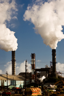
No comments:
Post a Comment