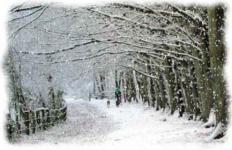
- Frozen precipitation in the form of white or translucent hexagonal ice crystals that fall in soft, white flakes.
- A falling of snow; a snowstorm.
- Just a gentle reminder....
- First potential snow accumulation? The end of next week (right around Nov. 13).
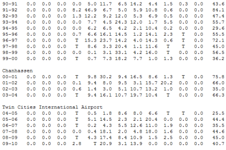
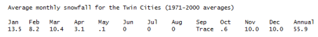
O.K. I got my snow tires put on Monday, and gazing at the long-range maps I'm starting to think it was a good move. We've seen our first flurries of the season (October 27) but no accumulation - yet. With a few exceptions winters have been cranking up later and later each season. Every winter Minnesota meteorologists say "this is the year - we're due for the BIG ONE! We're overdue for a real winter!" And we go through the winter, waiting, hoping, making excuses why the storms fizzled or weakened or detoured to the south. We spend the winter making excuses, making snow lovers even crazier. I've said it before - Minnesota has lost some of it's old fashioned Winter Mojo - we're not getting the quantity or quality of snow we saw in the 70s and early 80s. Sure, every once in a great while we get a real winter (like 2003-2004, when over 66" fell). But more times than not we're disappointed by the time late March rolls around.
Since 1990 only 1 in 4 winters, on average, has brought average or above average snowfall in the Twin Ciities. 25% The trend has been more sporadic snow, the snow that DOES fall tends to melt (many years we have to worry about whether we'll salvage a white Christmas, with at least 1" on the ground). Mark Seeley reports a 4X increase in midwinter rain and ice since 2000. More times than not we've "enjoyed" a Kansas City winter, or a Chicago winter.
Not complaining (although the snow lovers tend to look at me accusingly by the time February rolls around. Will 2010-2011 be different? Based on a strengthening La Nina the initial answer would be a cautious, qualified yes. There is a correlation between La Nina and colder/snowier. But it's not a perfect, iron-clad correlation. Yesterday I mentioned that a few models are actually hinting at another milder-than-normal winter for much of the lower 48 states east of the Rockies. My gut feeling (nausea?) I think we'll have more of an "average" winter, not as cold as many people are predicting, a little milder than normal, with more frequent snow events than we've experienced for most of the last decade. But I don't think it will be the knock-down, drag-out, perilously cold and dreadful winter some are anticipating.
Today will feel like November, a wind chill dipping into the 20s at times with more clouds than sun - cold, moist exhaust on the backside of yesterday's clipper keeping the sky overhead a bit raw and blustery. Under the center of a Canadian high lows dip into the mid 20s tonight (killing off the rest of the Box Elder bugs?) Bright sun is likely Friday and Saturday as winds ease up - more of a southerly breeze returning by Sunday & Monday, luring the mercury back into the 50s. A little rain is possible Tuesday as a colder front pushes across the state, and a developing wave of low pressure forming along that eastbound front may be the trigger for a more significant period of rain (and wet snow?) by the end of next week.
It's been too quiet for too long. We are DUE for some real "weather" - and I have a hunch a real storm is roughly 7-9 days away. It's time.
Paul's Conservation MN Outlook for the Twin Cities and all of Minnesota:
THURSDAY: More clouds than sun, gusty and November-like. NW 15-25 (wind chill dipping into the 20s). high: 43
THURSDAY NIGHT: Clearing and cold. Low: 25
FRIDAY: Cold start, bright sun, winds ease up a bit. High: 44
SATURDAY: Sunny and nice, light winds - very pleasant. High: near 50
SUNDAY: Partly sunny and milder, feels like October again. High: 54
MONDAY: Hints of Indian Summer with ample sunshine, still dry. High: 58
TUESDAY: Gray, periods of light rain developing by afternoon. High: 52
WEDNESDAY: Mostly cloudy, unsettled - cool & damp. High: 48
Winter Prognostication
A La Nina cooling phase is strengthening in the Pacific. The initial knee-jerk reaction might be to predict "colder & snowier" for much of America this winter (just like the Farmer's Almanac says). Not so fast. We're discovering (the hard way) that every El Nino & La Nina is different; other factors often come into play, like stubborn, persistent "blocking patterns" in the upper level winds.
While prevailing wisdom might predict a "real winter" (based on La Nina) the ECMWF (European) model is hinting at another unusually mild winter for much of the lower 48 states.
Minnesota winters are becoming increasingly erratic (and some would say - "neutered"). Just a generation ago it would snow in late October and that snow would STAY on the ground into early April. No more. The last time we had an "average" winter snowfall of 50+"? The winter of 2003-04 (66" fell and snow-lover were pleased).Each winter I say "we're due to get clobbered, statistically!", but the truth: no one really knows. Today will feel like November, but 50s return early next week. A little rain is possible Tuesday - a major storm MAY spin up just to our east next week, no imminent snowfall just yet.
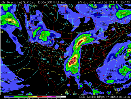
Slushy Accumulation Potential? It's still WAY early - but the GFS model is suggesting a close encounter with a potential snowstorm the end of next week - right around Friday the 12th and Saturday the 13th. Precipitation will probably start as rain - but an intensifying storm near Chicago may pull enough cold air into its circulation for a changeover to wet snow, and yes, I could see a few inches of slush, especially south/east of the Twin Cities.
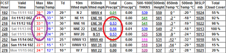
Looks Like Winter. The kid gloves may come off within 10 days, give or take. The GFS prints out over 1" of precipitation, starting as rain, mixing with and changing to snow by late Friday and Saturday. It's too early to even speculate about amounts - just throwing up a red (yellow) flare, alerting you to the POSSIBILITY of slush by the end of next week.
No comments:
Post a Comment