* Today: 5-10 degrees above average, but Thursday will feel like November (wind chill in the 20s).
* Dry weekend, Saturday looks like the sunnier day, 50s return Sunday.
* Rain possible by the middle of next week, maybe ending as a period of wet snow by next Thursday (probably just flurries in the Twin Cities).
* A touch of winter possible by the third week of November. Enjoy the extended weather honeymoon!

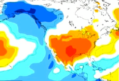
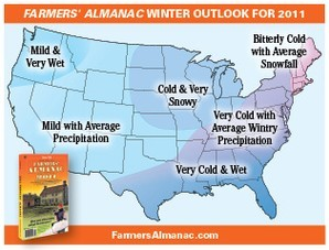
Winter Outlook. La Nina, La Schmeena! According to the ECMWF (European) supercomputer model - which many meteorologists believe to be superior to NOAA's long-range outlooks - is predicting a warmer than normal winter for much of the lower 48 states. There is growing evidence that this may be an atypical La Nina (ie. not necessarily colder and snowier across the board). I think we'll see plenty of arctic fronts (nothing new there) but it won't be quite as cold as some forecasters are predicting. Meteorologist Kirk Melhuish in Atlanta has some interesting thoughts about the winter to come here.
Significant Weather Events:
- All 4 weeks of October trended warmer and drier than last year in the United States. In Canada all weeks were warmer than last year and all weeks trended drier with the exception of the final week of the month.
- The Columbus Day weekend ended much warmer than last year and warmer than normal. It was slightly wetter than 2009 but otherwise the 2nd driest since 2000. The warmer and drier conditions led many to be out and about, with outdoor activities and lawn care products benefiting compared to last year.
- For the Halloween weekend trick-or-treaters were “treated” to pleasant weather with many locations recording near normal temperatures and dry conditions.
- While there were minimal impacts to the U.S. in regards to the tropical season this October, we still saw a very active month with 5 named storms. Hurricane Otto (week 1), Hurricane Paula (week 2), Hurricane Richard (week 3) and Hurricane Shary and Tomas (week 5) all were named in the month of October. The 2010 tropical season has tallied 19 named storms to date, 9 of which reached hurricane status, which is the most since 2005.
- Snowfall in the U.S. for the month was down 73% compared to 2009 and down 60% to normal.
- Los Angeles was the 14th coldest in 50 years and slightly cooler than 2009.
- San Francisco was 2nd warmest in 50 years, warmest since 1992.
- South Central was driest since 1963 (2nd driest in 50 years).
- Southeast was driest since 2000.
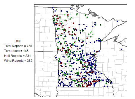
- West North Central was driest since 2003
Above data and weather headlines courtesy of Planalytics.

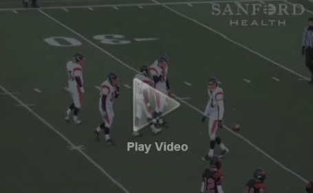
86 Yard Punt Gets Some Help From The Wind. The highlight of the Washington Warriors high school football game last weekend was an 86 yard punt that you have to see to believe. The winds were howling, and the ball just kept on rolling and rolling and rolling....

Fine Election Day. Sunshine held on most of the day across the state, enough blue sky for 56 in St. Cloud (where a trace of sprinkles fell), 56 in the Twin Cities and 59 at Redwood Falls. These temperatures are 8-10 degrees warmer than average for November 2.
Paul's Conservation MN Outlook for the Twin Cities and all of Minnesota:
WEDNESDAY: Partly sunny, stiff breeze. NW 15-25 High: 54
THURSDAY: Blustery, feels like November again with a mix of clouds and sun! High: 43 (wind chill dipping into the 20s)
FRIDAY: Cold start, sunny, less with wind. High: 44
SATURDAY: Sunnier day of the weekend, still brisk (winds ease up). High: 49
SUNDAY: Mix of clouds & sun, a bit milder. High: 53
MONDAY: Intervals of sun, still uneventful, a few degrees warmer than average. High: 52
TUESDAY" Some sun, clouds increase - last dry day? High: 51
* A cold rain is possible next Wednesday, slight chance rain may end as a few flurries next Thursday.
A Minor Clipping
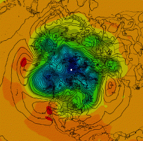
It may not be a particularly profound observation, but I've noticed the longer we enjoy dry, quiet (mild) weather, the worse the inevitable storm to come. Case in point: October 2010. We really had 2 Septembers, back to back (and got a little complacent in the process). Then, like a popped balloon, last week's "Landicane" spins up a central pressure of 28.21" over Bigfork, MN, roughly equivalent to a Category 3 hurricane. Think of weather as an elastic balloon. A steady supply of cold fronts & storms leaves a little air out of the balloon. But if the weather is too tranquil for too long the balloon inflates - and eventually pops (resulting in chaos here on the ground).
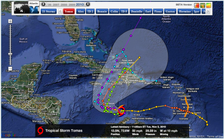
Speaking of weather-chaos, Hurricane Tomas hit Barbados & St. Lucia hard, possibly the worst hurricane since 1955. We've had 12 hurricanes in the Atlantic this year, the second most on record (topped only by 2005, with 15 hurricanes).
A clipper whips up cool, Canadian exhaust, heavy jackets return tomorrow, but dry weather hangs on through next Tuesday. Low 50s return Sunday & Monday, a cold rain by next Wednesday may end as a few flurries next Thursday. The third week of November will FEEL like November!
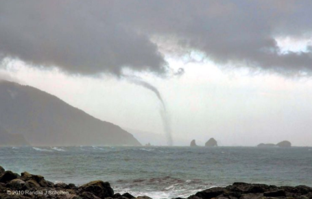
More Waterspouts In Unusual Places. On October 24 an unusual phenomenon greeted residents of the Oregon coast - a waterspout (tornado over the water) developed just offshore. An amazing and bizarre sight for coastal Oregon!
No comments:
Post a Comment