* Biggest snow for the Twin Cities since the Halloween Superstorm of 1991.
* Reports of 3-6 foot drifts around the metro, the most snow on the ground in 19 years.
* That snow isn't going anywhere anytime soon - no thaws in sight through Christmas Day. There will be some "settling" as the sheer weight of the snow compacts the accumulation - some "shrinkage" in the coming days, but for snow lovers this is truly as good as it's ever 'gonna get!
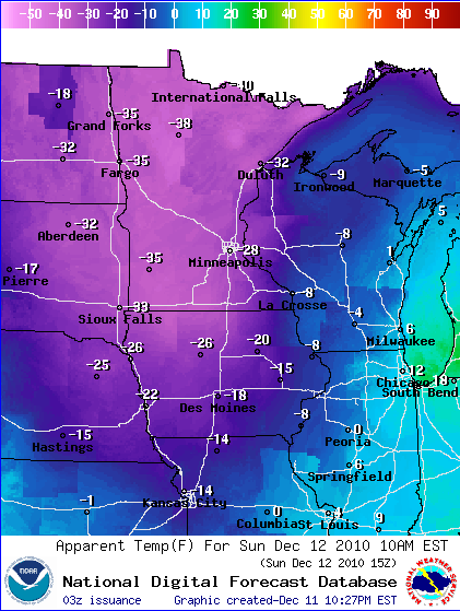
* Wind chills dip to -30 today in spite of bright sunshine. Winds gusting to 25 mph. will produce more drifting, especially outside the metro (where travel conditions should slowly improve as the day goes on and plows get back on the highways).
* -15 tonight, as cold as -21 late Monday night/Tuesday morning. The core of the Arctic air drifts over Minnesota during the day Monday, probably the coldest day of the next 3. By midweek temperatures start to moderate (a bit). Low 20s will actually feel remarkably good by Thursday.

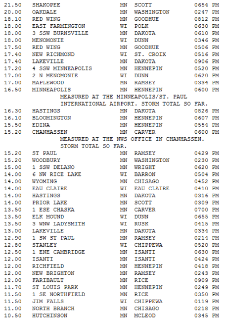
Most Recent Snowfall Totals....
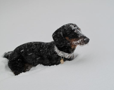
It's Tough Being A (Little) Dog. Say hi to "Bentley", a tiny little dachsund living out in Chanhassen, who seemed to enjoy the snow but had a HECK of a time "doing his business", according to owner Tricia Frostad.
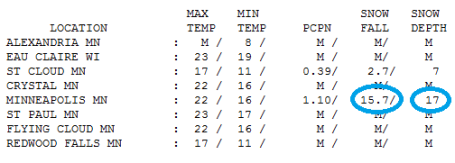
"Snowmageddon". 1-2 feet of snow in the metro? What parallel universe are we living in - where it actually snows in the Twin Cities, just like it did back in the 70s and early 80s? Over 1" liquid in the Twin Cities translated into nearly 16" at MSP International Airport, 17" on the ground. Nearly 3" fell in St. Cloud, but some 4-7" amounts were common in other towns across Stearns County.
Paul's Conservation Minnesota Outlook for the Twin Cities and all of Minnesota:
SUNDAY: Sun returns, probably one of the 3-5 coldest days of the winter season. Wind chill: -30. NW 15-25. High: 0
SUNDAY NIGHT: Clear and frigid. Low: -15
MONDAY: Welcome to Siberia. Blue sky, subzero "high". High: -3
MONDAY NIGHT: Coldest night - temperatures bottom out. Low; -21
TUESDAY: Bitter start, clouds increase. High: 5
WEDNESDAY: A little light snow, inch or 2 possible. High: 17
THURSDAY: Leftover flakes, as "mild" as it's going to get through next week. High: 23
FRIDAY: More clouds than sun - still (relatively) comfortable. How far we've fallen... High: 22
SATURDAY: More clouds than sun, colder. High: 17
Snow Blitz of '10
My loyal weather spotters at KFAN-AM confirm over a cool 1-2 feet of snow for most of the metro. Wow! Snow lovers woke up to an early Christmas present - like the winters your parents (or grandparents) described, with a touch of (pained) nostalgia. "Paul, I can remember some winters where the snow came up to my chin!" True. But remember you were 2 feet tall at the time.
The Snow Blitz of '10 is winding down, but monster drifts will linger through a VERY white Christmas this year. Latest GFS guidance suggests the warmest we'll be between now and Christmas Day is Thursday, when we may see 22 (above). That "real winter" I was talking about 2 months ago seems to coming true, after all, no thanks to a strong La Nina cooling of Pacific ocean water.
Will we see a correction in January, a series of Pacific thaws? Very possible, but there's little question the atmosphere east of the Rockies is stuck in an Arctic rut, a blocking (holding) pattern that shows NO sign of letting up anytime soon.
MnDOT may have major roads dug out by afternoon - consider checking in on older neighbors nearby; the risk of frostbite and hypothermia (drop in body temperature) will be high. The blog has updates. Be safe. Enjoy the most snow from a single twin Cities snowstorm in 19 years.
No comments:
Post a Comment