Storm Headlines:
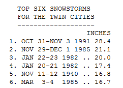
* 17.1" snow reported at MSP International Airport, making this the 5th biggest snowstorm for the Twin Cities in modern-day records.
*
Biggest snow for the Twin Cities since the Halloween Superstorm of 1991.
* Reports of
3-6 foot drifts around the metro, the most snow on the ground in 19 years.
* That snow isn't going anywhere anytime soon -
no thaws in sight through Christmas Day. There will be some "settling" as the sheer weight of the snow compacts the accumulation - some "shrinkage" in the coming days, but for snow lovers this is truly as good as it's ever 'gonna get!
*
Wind chills dip to -30 today in spite of bright sunshine. Winds gusting to 25 mph. will produce more drifting, especially outside the metro (where travel conditions should slowly improve as the day goes on and plows get back on the highways).
* -15 tonight, as cold as -21 late Monday night/Tuesday morning.
The core of the Arctic air drifts over Minnesota during the day Monday, probably the coldest day of the next 3. By midweek temperatures start to moderate (a bit). Low 20s will actually feel remarkably good by Thursday.
Snowy Wasteland. Here is the view from the tower at MSP International - crews have been working overtime to clear main runways and taxiways. Photo courtesy of Todd Nelson, a meteorologist at WeatherNation, who also works for the National Weather Service as a professional weather observer at KMSP.
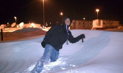
Stranded. Todd Nelson was supposed to work a single shift on Saturday at MSP International. His relief never showed up (he's on his third shift in a row - still stuck at the airport!) He's trying to keep his sense of humor - he sent me this photo showing some of the drifts at the airport last night. Amazing....
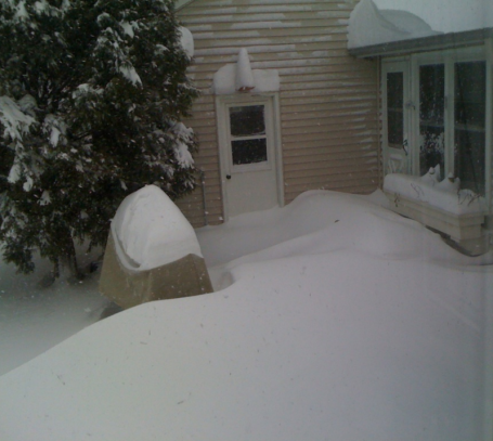
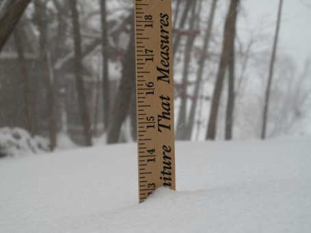
Smothered In Snow. This is my backyard - somewhere out there is my grill, buried under 4-6 foot drifts. Yes, at the rate we're going its going to be a VERY white Christmas.
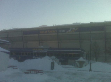
Dome-Less. Thanks to the Star Tribune for updating us on the sorry state of the Metrodome, where a rip in the inflatable roof created a worst-case scenario. No football for the forseeable future. Check out "
SnowCam" for a live webcam view from the top of the Metrodome.
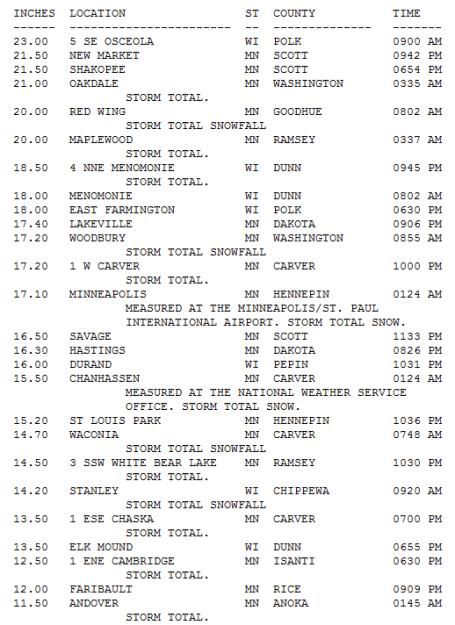
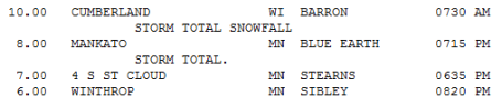
Updated Snowfall Totals....
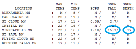
Preliminary Snow Totals. Congratulations Osceola, WI. You just claimed the coveted (?) Golden Snow Shovel Award, for 23" of snow and towering 5 foot drifts. Strange but true: downtown St. Cloud (the airport, really) picked up 2.7". Just 4 miles south of downtown St. Cloud a whopping 7" fell. It's those kinds of variations (4-5" over the span of 4 miles) that leave us plucking at our (gray) hairs. Check out the very latest numbers from the National Weather Service
here.
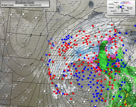
What Just Happened? A combination of factors made Saturday's storm extra-severe. A sharp contrast in temperature (it was 34 here Thursday - yesterday subzero air surged southward into the Red River Valley) whipped up powerful winds. Generally, the greater the temperature contrast, the stronger the winds have to blow to keep the atmosphere in a state of equilibrium. Another factor, the "Colorado-type" storm tracked south of Minnesota, from Omaha to Des Moines to the Quad Cities and Rockford, far enough south to keep precipitation all-snow in the Twin Cities metro. It also moved relatively slowly, producing nearly 25 hours of snow (8 hours of heavy snow - from 9 am until 4 pm at MSP). Another factor: the temperature: snow falling at 18-21 degrees is light, powdery - fluffy - more air puffing up the flakes like feathers in a down comforter. The snow accumulates much faster than when temperatures are in the upper 20s to near 30. Had temperatures been closer to 30 we would have seen less than half as much actual accumulation.
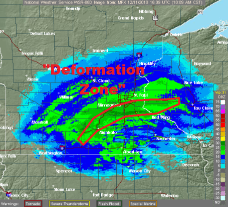
. Remember I mentioned about the difficulty of trying to pin down where the dreaded "deformation zone", the back edge of the heaviest/steadiest snow band would set up? On Thursday and Friday most (not all) of the models were hinting that this zone of rapidly rising air would set up - and temporarily stall out - directly over the Twin Cities metro area. As the storm track across Iowa into northern Illinois the heavy snow band remained draped over MSP for much of the day, enhancing snowfall amounts as 30-40 degree air was thrust up and over an oncoming Arctic airmass with temperatures in the single digits and teens. Where that air rose (violently), snow fell at the rate of 1-2"/hour.
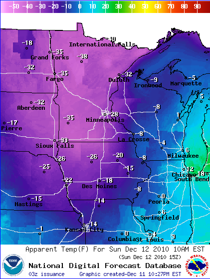
Bitter Breeze. In spite of some tentative sunlight, temperatures may not climb above zero across most of Minnesota today, a stiff northwest wind at 15-25 making it feel like -20 to -40 much of the day. The 10 am wind chill is forecast to be -28 F. in the Twin Cities, -32 at St. Cloud and -35 F from Windom to Fargo/Moorhead. If you're heading out to play in all that fresh new Colorado-like powder, remember all those wise words of wisdom your mom taught you growing up: multiple layers, face mask, warm hat and gloves - if you're active (and take frequent indoor breaks) you should be OK.
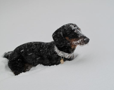
It's Tough Being A (Little) Dog. Say hi to "Bentley", a tiny little dachsund living out in Chanhassen, who seemed to enjoy the snow but had a HECK of a time "doing his business", according to owner Tricia Frostad.
"Snowmageddon". 1-2 feet of snow in the metro? What parallel universe are we living in - where it actually snows in the Twin Cities, just like it did back in the 70s and early 80s? Over 1" liquid in the Twin Cities translated into nearly 16" at MSP International Airport, 17" on the ground. Nearly 3" fell in St. Cloud, but some 4-7" amounts were common in other towns across Stearns County.
Paul's Conservation MN Outlook for the Twin Cities and all of Minnesota:
SUNDAY: Sun returns, probably one of the 3-5 coldest days of the winter season. Wind chill: -30. NW 15-25. High: 0
SUNDAY NIGHT: Clear and frigid. Low: -15
MONDAY: Welcome to Siberia. Blue sky, subzero "high". High: -3
MONDAY NIGHT: Coldest night - temperatures bottom out. Low; -21
TUESDAY: Bitter start, clouds increase. High: 5
WEDNESDAY: A little light snow, inch or 2 possible. High: 17
THURSDAY: Leftover flakes, as "mild" as it's going to get through next week. High: 23
FRIDAY: More clouds than sun - still (relatively) comfortable. How far we've fallen... High: 22
SATURDAY: More clouds than sun, colder. High: 17
Snow Blitz of '10
My loyal weather spotters at KFAN-AM confirm a cool 1-2 FEET of snow for most of the metro. Wow. Snow lovers woke up to an early Christmas present - like the winters your parents (or grandparents) described, with a touch of (pained) nostalgia. "Paul, I can remember some winters where the snow came up to my chin!" True. But remember you were 2 feet tall at the time.
The Snow Blitz of '10 is winding down, but monster drifts will linger through a VERY white Christmas this year. Latest GFS guidance suggests the warmest we'll be between now and Christmas Day is Thursday, when we may see 22 (above). That "real winter" I was talking about 2 months ago seems to coming true, after all, no thanks to a strong La Nina cooling of Pacific ocean water.
Will we see a correction in January, a series of Pacific thaws? Very possible, but there's little question the atmosphere east of the Rockies is stuck in an Arctic rut, a blocking (holding) pattern that shows NO sign of letting up anytime soon.
MnDOT may have major roads dug out by afternoon - consider checking in on older neighbors nearby; the risk of frostbite and hypothermia (drop in body temperature) will be high. The blog has updates. Be safe. Enjoy the most snow from a single twin Cities snowstorm in 19 years.

No comments:
Post a Comment