Latest Storm Headlines
* This has the potential to be the
biggest snowstorm for much of Minnesota since Halloween, 1991.
* Potential for
1-2 feet of snow Saturday, with 2-5 foot drifts during the PM hours.
*
Close to blizzard criteria - best chance of white-out conditions south/west of the metro area.
* Get your errands/shopping done today,
snow arrives late evening, between 8 and 10 pm, snow gets heavier and steadier as the night goes on - should be snowing heavily when we wake up Saturday morning.
*
Conditions get worse as the day goes on tomorrow as winds increase and snow accumulates (even on the freeways and interstates).
*
Wind chills by Saturday night dip down to -20 to -35,
extreme danger zone.
*
Highs hold below zero on Sunday, but travel conditions should gradually improve - personally, I wouldn't plan on hitting the highways again until Sunday afternoon at the earliest.
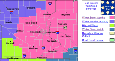
Winter Storm Warnings - Blizzard Watch. Here is the latest from the NWS in Chanhassen. The watch has been upgraded to a warning, meaning its imminent - it's coming. Not sure how we see anything less than 8" of powder. At the upper end: 15-20" amounts can't be ruled out. For more details click
here.
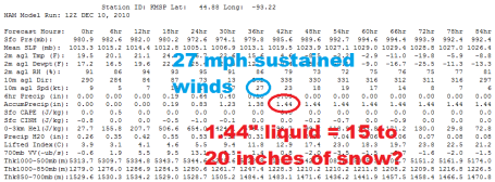
Latest Numbers. Here is why I believe tomorrow's storm will result in the most snow for MSP since the Halloween Superstorm of 1991. The most reliable model, the NAM/WRF, is printing out 1.44" liquid. Assuming an AVERAGE snow/rain ratio of 15/1 during the life of the storm (starting out close to 10/1 tomorrow morning, could be closer to 25/1 at the end of the storm when temperatures fall below 10 F) I come up with 15-20" of accumulation. Not sure how we see anything less than 8". Now that all the models are coming into alignment our confidence level is growing. Yes, it's going to be a VERY significant pile of snow - winds of 27 mph (sustained) predicted for the dinner hour Saturday, meaning surface winds may be in the 30-35 mph range, very close to blizzard criteria. Even if it isn't a full-fledged blizzard in the metro, I do expect blizzard conditions, especially south/west of MSP.
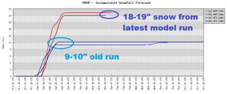
Snowy Trends. The models are not only coming into alignment (the continuity we're looking for), but every successive model run gets snowier and snowier. The older runs were hinting at 9-10" of snow - the latest runs are in the 18-19" range. I expect to see some 2-5 foot drifts by Saturday night.
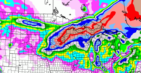
How Much? Here is the latest model run, showing a band of 15-28" extending from the MSP meetro area into much of northern Wisconsin and the U.P. of Michigan. This band may still shift (slightly) over the next 12-24 hours, but again, I just don't see how we see anything less than a foot in the metro area. Frankly, as time goes on I'm starting to think final amounts may be closer to 2 feet.
We'll see, but
this has all the hallmarks of a major blizzard for much of the Upper Midwest, something we haven't seen for nearly 2 decades.
No comments:
Post a Comment