Latest Storm Headlines
* This has the potential to be the
biggest snowstorm for much of Minnesota since Halloween, 1991.
*
3-5" possible by breakfast on Saturday, another 10" or so expected during the day.
*
Ice Potential: southern MN may see glaze ice and sleet for a time tonight and early Saturday, potential for significant ice build-up.
* Potential for
1-2 feet of snow Saturday, with 2-5 foot drifts during the PM hours.
Official prediction is 12-16". I can't remember the last time I predicted that much snow for the metro. We'll see if it actually arrives....I kind of hope I'm wrong this time around.
*
Close to blizzard criteria - best chance of white-out conditions south/west of the metro area. Blizzard warnings now issued for far southwest and west central MN.
*
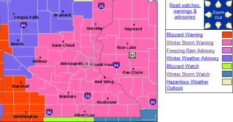
Winter Storm Warning for much of Minnesota/Wisconsin. .
* Get your errands/shopping done today,
snow arrives late evening, between 8 and 10 pm, possibly starting as a period of sleet or freezing rain, snow gets heavier and steadier as the night goes on - should be snowing heavily when we wake up Saturday morning.
*
Conditions get worse as the day goes on tomorrow as winds increase and snow accumulates (even on the freeways and interstates). Temperatures will fall through the teens into the single digits - making it a light, powdery snow - prone to blowing and drifting.
* I know this is a mouthful, but
travel simply isn't recommended Saturday and Saturday night. Never tell a Minnesotan not to travel, I get it. But the combination of snow/wind/falling temperatures will create truly treacherous conditions. If you run out of gas or go into a ditch tomorrow it could be more than just a minor inconvenience. With wind chill values dipping to -25 or lower it could quickly become life-threatening. Try to get your travel done by this evening, or plan on waiting until Sunday (afternoon) to get back on the highways.
*
Wind chills by Saturday night dip down to -20 to -35,
extreme danger zone.
*
Highs hold below zero on Sunday, but travel conditions should gradually improve - personally, I wouldn't plan on hitting the highways again until Sunday afternoon at the earliest. Temperatures rebound into the 20s by the middle of next week - it won't stay frigid for long.
Blizzard Warnings Southwestern MN. Here is the latest from the NWS in Chanhassen. The watch has been upgraded to a winter storm warning, meaning its imminent - it's coming. Not sure how we see anything less than 8" of powder. At the upper end: 15-20" amounts can't be ruled out. Blizzard warnings are now posted from Wheaton and Breckenridge to Marshall, Windom and Worthington. For more details click
here.
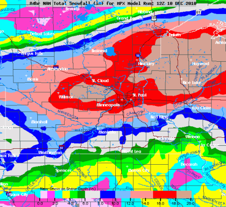
Colors I Haven't Seen Before. Good grief - check this out. A band of 12-20" setting up directly over the metro (latest NAM/WRF printing out the best chance of 20" just north/west of MSP, closer to Monticello, Rockford and Hutchinson. Not sure how we see anything less than a foot at this point, and the final numbers may be closer to 15-20" for parts of the metro. The problem: at some point all this preoccupation with inches won't matter. The snow will blowing and drifting so much you won't be able to get an accurate measurement Saturday PM hours.
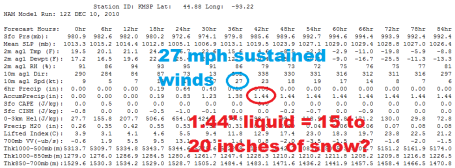
Latest Numbers. Here is why I believe tomorrow's storm may result in the most snow for MSP since the Halloween Superstorm of 1991. The most reliable model, the NAM/WRF, is printing out 1.44" liquid. Assuming an AVERAGE snow/rain ratio of 15/1 during the life of the storm (starting out close to 10/1 tomorrow morning, could be closer to 25/1 at the end of the storm when temperatures fall below 10 F) I come up with 15-20" of accumulation. Not sure how we see anything less than 8". Now that all the models are coming into alignment our confidence level is growing. Yes, it's going to be a VERY significant pile of snow - winds of 27 mph (sustained) predicted for the dinner hour Saturday, meaning surface winds may be in the 30-35 mph range, very close to blizzard criteria. Even if it isn't a full-fledged blizzard in the metro, I do expect blizzard conditions, especially south/west of MSP.
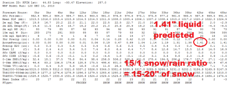
Continuity. One of the things we look for is a). trends over time, and b). continuity (agreement) between the various models. The WRF model is predicting 1.41", very similar to the NAM (above) which is spitting out 1.44". Confidence is rising that we'll pick up at least a foot - a few spots, especially northern/western suburbs could see closer to 20" unless the storm takes a strange deviation from its predicted path (which could still happen). The odds of that happening have diminished, but they're not zero. Even so, not sure how we see anything less than 6-8" from tomorrow's storm.
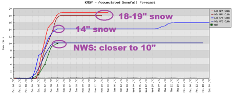
Latest Trends. The models are not only coming into alignment (the continuity we're looking for), but every successive model run gets snowier and snowier. The very latest NAM/WRF runs are hinting at 18-19", a few other runs closer to 10-14". The official NWS thinking is closer to 10" but even that number is coming up over time.
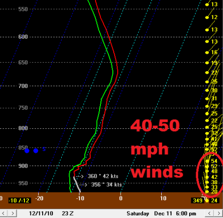
Skew-T. Models are predicting 40-50 mph winds just 1,000 feet above the ground around 6 pm Saturday. Some of this high-velocity air may reach the ground - increasing the potential for near-blizzard conditions, especially outside the metro area.
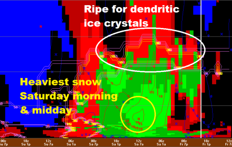
Storm Cross-Section. This map reads from right to left (go figure), a timeline that shows a). ripe conditions for dendritic ice crystal growth Saturday, and b). the heaviest burst of snow comes from late tonight through early afternoon Saturday, possibly falling at the rate of 1" every hour or two.
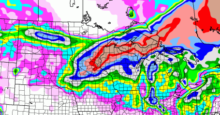
How Much? Here is the latest model run, showing a band of 15-28" extending from the MSP meetro area into much of northern Wisconsin and the U.P. of Michigan. This band may still shift (slightly) over the next 12-24 hours, but again, I just don't see how we see anything less than a foot in the metro area. Frankly, as time goes on I'm starting to think final amounts may be closer to 2 feet. We'll see, but
this has all the hallmarks of a major blizzard for much of the Upper Midwest, something we haven't seen for nearly 2 decades.
No comments:
Post a Comment