* We are halfway through the "storm" (snow event). Google Traffic shows gridlock conditions (see below) and travel will get worse before conditions slowly improve on Saturday.
* Even freeways/interstates remain snow covered and icy overnight. A good night to stay home and catch Conan?
* Wind relatively light (under 15 mph) meaning only minor blowing and drifting.
*
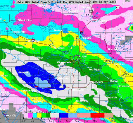
Starting to believe snow totals will be in the 4-8" range, best chance of 6-8" southern/western suburbs, with 6" for the downtowns and close-in suburbs, 2-4" north metro.
* Sunday: mid teens under bright sunshine, coldest since Feb. 1?
Snowfall So Far. Wow. The snow is piling up rapidly - lot's of air between the flakes, like a down comforter. 7" so far at Nicollet and Mankato, over 4" at Bloomington and Shakopee - where some 8" amounts seem all but inevitable right now. Click
here to see the latest snowfall reports from the NWS.
On Track For A Cool Half Foot? Yes, it still looks "plowable", at least 4-8" for much of the metro area, but I'm feeling even more confident that we'll see enough snow to shovel and plow. I'm also a bit more confident that the southern and western suburbs will pick up that 8" of snow.
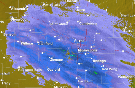
Doppler Radar: 8:45 pm. The heaviest snow bands are still setting up over the western and southern suburbs - which stand the greatest chance of picking up 6-8" by Saturday afternoon. Snow will continue to pick up in intensity through the nighttime hours, falling at the rate of 1" every 2 or 3 hours. We are roughly halfway through the storm.
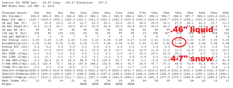
Feeling More Confident about 6-8". The latest WRF model prints out .46", with a 15/1 ratio that should equal about 6" (or more) of snow by Saturday afternoon. Winds will be light Saturday, meaning minimal blowing and drifting. But highways will be very slippery, especially AM hours.
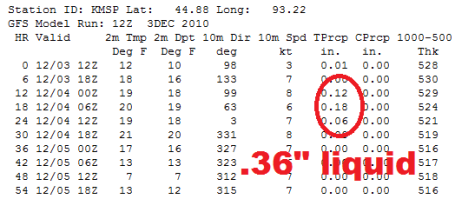
More Numbers. The latest GFS model prints out .36", which equates to 5 or 6". Everything is leading us to believe that this will be a 4-7" snowfall, less north/east, more south/west.
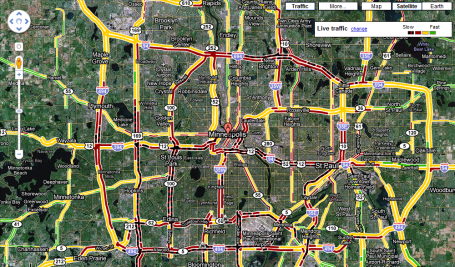
Gridlock. Google Traffic as of 6:30 showed near parking lot conditions, especially 494, Highway 100, Crosstown and I-94 between Ridgedale and St. Paul. Other than that - lovely out there! This might be a good night to avoid the freeways at all costs. To see the latest traffic map click
here.

No comments:
Post a Comment