* Snow tapers to flurries Saturday (another 1/2 to 1" possible during the day).
* Travel conditions slowly improve during the day Saturday.
* Average December snowfall for MSP: 10". At this rate we will have a very "white" Christmas this year.
* 14 degree high Sunday, coldest since Feb. 1, 2010.
* GFS hinting at a well-deserved thaw the third week of December.
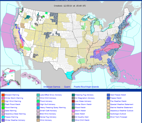
Snowy Trail Of Trouble. Yes, it's trouble for travelers trying to get around, but pure, white, crystalline heaven for a lof of Minnesotans who LOVE snow! It's a Dickens saga: best of times, worst of times. Driving early today will be a mess, but if you're hoping to ski, wax up the snowboard, hit the trails with your snowmobile, or just build a snowman in the front yard - today will be an amazing day to PLAY in the snow. The latest watches/warnings from the NWS are
here.
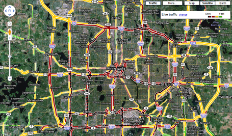
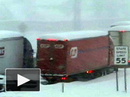
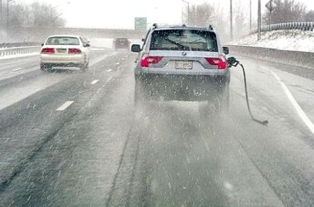
 Friday Night Gridlock
. This is what the metro area looked like around 7 pm last night, possibly the worst travel conditions I've ever seen. Conditions will improve today, and a lack of high winds should mean only minimal blowing and drifting (a good thing, considering how dry and powdery the snow is). For the latest Google traffic update click
here - might be a good idea to check before you venture out onto the highways.
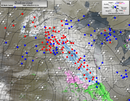
Anatomy Of A Clipper. Friday night's clipper featured an intensely focused band of moderate snow streaking southeastward across the state at 30 mph, a 75 mile wide band of snow. A slight difference in the track, even 10 miles, can make the difference between flurries, and a cool half foot of flurries. See the latest high-res weather map for yourself by clicking
here, courtesy of Meteostar.
A Snowy Dumping. 39" of lake-effect snow in Buffalo (and counting). A few towns just north/east of Buffalo have picked up as much as 42" of snow - closing in on 4 FEET of the white stuff! Check out this YouTube
clip from the Buffalo area, which has been virtually shut down by 3 days/row of heavy, persistent snow sweeping in off Lake Erie.
Snowy Gridlock. Talk about a vehicular nightmare. A massive accident near Buffalo has essentially shut down traffic going in any direction - the main interstates are gridlocked and virtually impassable, people abandoning cars and trucks, seeking shelter, trying to get out of the cold and snow, which has produced white-out conditions across much of western New York state. An update from MSNBC
here.
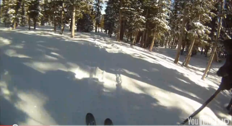
"Colorado Powder" Consider this video an omen of what's to come. Please don't try this at home (unless you're an accomplished skier. This guy had a camera attacted to his helmet (I hope) and he made me want to purchase a ticket to Vail to check out the 2-4 feet of new powder. But then again I may just stay close to home, hit Afton Alps or Highland Hills to ski in some old fashioned Minnesota Powder - as good as it gets if you're a winter weather enthusiast. The video clip is
here (rated PG for some salty language - words that would probably be coming out of my mouth if I were foolish enough to attempt such a stunt).
A Thaw In Sight? Sick and tired of the premature bouts of uncontrollable shivering? You're not alone. The atmosphere usually adjusts, compensates for extremes. Unusual spells of cold weather are USUALLY followed by spells of unusually warm weather. I don't want to get your hopes up too high, but the GFS model is hinting at a nice thaw the third week of December, highs in the 30s to near 40. We'll see.
Wild and Wintry. More on the wave of cold, snowy weather sweeping across Europe from monstersandcritics.com
here.
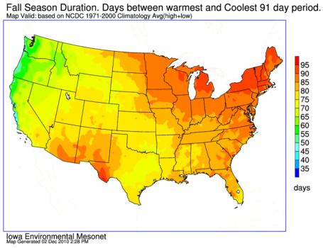
Who Enjoys The Longest Fall? Here is a vaguely interesting graphic, showing which states have the longest duration of autumn. New England wins the price, with the Great Lakes and Upper Midwest coming in a close second. ON average we see an 85 day interval between the warmest and coolest temperatures during the fall.
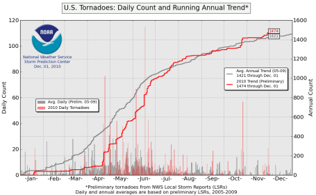
USA Tornado Count. From SPC comes word that 2010 is running slightly above average in the preliminary tornado count (1474 vs. an average of 1421 as of December 4). Source:
SPC.
Journalism Is In Hour Of "Grave Peril", Says Top Government Regulator. So much data - so little wisdom. Consumers are turning into their own news directors, deciding which "new" gets through, choosing from a seemingly infinite number of articles (and blogs) to get their information, often choosing news sources that align with their political leanings. Here is an excerpt from a recent
article in the Los Angeles Times: "
Federal Communications Commissioner Michael Copps is taking aim at the state of television news, which he says is "in its hour of grave peril." In both an interview with BBC World News America that airs Wednesday and in a speech at Columbia University's School of Journalism he is to deliver Thursday, Copps charges that the media is falling far short when it comes to serving the public. American media is not "producing the body of news and information that democracy needs to conduct its civic dialogue," Copps said in an interview with the BBC's Katty Kay. That trend, he added, has to be reversed or "we are going to be pretty close to denying our citizens the essential news and information that they need to have in order to make intelligent decisions about the future direction of their country.”
Holiday Gift Ideas For Tablet Lovers? I stumbled on a great
article in the New York Times that highlights some of the tablet options you may want to consider. I'm a bit biased (I love my iPad). I find myself multitasking on the couch: the TV on (background Muzak), the laptop fired up, but it's so convenient (and addictive) browsing content on your iPad, everything from Twitter and FB posts (download the Flipboard app, you won't be disappointed)) to streaming movies from Netflix. It's nice to have options!
 Paul Douglas Foundation
. Click
here to learn more about the charities I'm supporting with my speaking tour, touching on topics ranging from climate change to entrepreneurial war stories (I believe everyone has at least one business in them, and all companies can benefit from thinking like a "start-up"). If your company or service organization is looking for a multimedia presentation that rallies the troops and gets the creative juices pumping, consider supporting the foundation.
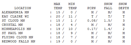
Friday Flakes. With a high of only 19 in the Twin Cities (15 at St. Cloud) the snow/rain ratio was probably closer to 20/1 (meaning 20" powdery/fluffy snow for every inch of rain). If we really do pick up .3 to .4" liquid that should translate into 6-8" for much of the metro, especially south of the downtowns. By 7 pm 1.4" had accumulated at MSP, 1.5" at St. Cloud.
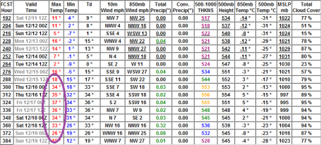
Paul's Conservation MN Outlook for the Twin Cities and all of Minnesota:
TODAY: Storm Warning early. Snow tapers to flurries, another 1/2 to 1" of powdery snow. Winds: NW 10-15 (meaning minimal blowing/drifting). High: 22
SATURDAY NIGHT: Flurries taper, partial clearing, plenty cold. Low: 3
SUNDAY: Arctic sunshine, bundle up! Coldest day since Feb. 1. High: 14
MONDAY: Blue sky, welcome to the Yukon. Low: 0 (subzero outlying suburbs). High: 15
TUESDAY: Plenty of sun, still 10 degrees colder than average. High: 19
WEDNESDAY: Still can't feel my toes. Fading sun - bitter. High: 14
THURSDAY: Clipper triggers light snow north, metro flurries. High: 22
FRIDAY: Patchy clouds, few flakes. High: 24
Minnesota Powder
Forget Breckenridge, Vail and Aspen. We just saw our own "Colorado Snow": light & powdery, perfect for sledding, skiing, or (in my case) falling down the slopes on a snowboard. I may even have to fire up the snowmobile (because that's what we do up here). We roll with the atmospheric punches, make the best of the situation.
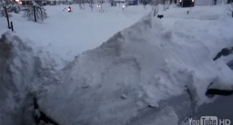
A few old-timers grumbled, "It wasn't nearly this bad back in the 70s - the roads would be cleaned up within a few hours!" Keep in mind that there are probably 2 to 3 times more vehicles in the metro now, and snow at 20 degrees is MUCH harder to melt than snow close to 30-32 F. MnDot has its work cut out for it today; the heaviest snow quickly tapers to flurries, maybe another inch. Some 'burbs just south/west of MSP may wind up with 8" of powder.
Good news: winds will be light, under 15 mph, meaning minimal blowing and drifting.
The sun will be out Sunday, but it won't matter much; highs in the mid teens, the coldest front since Feb. 1, 2010. Feel like a pioneer yet? I know this early blast of snow and cold has some people feeling on edge. The GFS model is hinting at a thaw the third week of December. Until then, plenty of time to romp in the snow!
How To Protect Yourself From A Potentially Deadly Rental Car. I know, it sounds like a sensational "sweeps" story on local TV. But Brian Ross over at ABC News has put together a jaw-dropping story about lax standards for many rental cars. It's the kind of thing I don't even think about when I'm renting a car - not until I saw
this report.
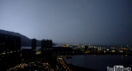
Wild Lightning Display in Hong Kong. From the 56th floor of an office tower in Hong Kong - an amazing display of cloud to ground lightning. Check out the YouTube video
here.
What About Global Warming? Here is an intriguing
article that attempts to "bridge the gap between science and faith." From an article at reasons.org: "Global warming. This topic evokes strong emotions and reactions from many different camps. The debate often occurs in only the political realm with the scientific evidence entering to support a specific agenda, causing controversy and distrust between differing groups. But we can diffuse the rancor by allowing the scientific data to speak
first and then determining the course of action that best benefits humanity. RTB’s position incorporates such an approach.
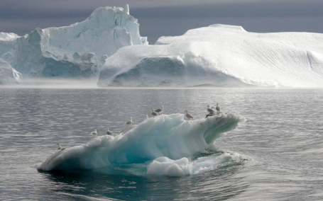
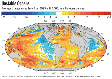
Sea Level Could Rise In The South, Fall In The North. An interesting
article from the German publication: Der Spiegel, which does some impressive investigative journalism: "
Climate change is expected to cause sea levels to rise -- at least in some parts of the world. Elsewhere, the level of the ocean will actually fall. Scientists are trying to get a better picture of the complex phenomenon, which also depends on a host of natural factors. When presented as a globe, the Earth looks as round and smooth as a billiard ball. To anyone standing on a beach, the ocean looks as flat as a pancake.
But perception is deceptive. "In reality, the water in the oceans wobbles all over the place," says oceanographer Detlef Stammer. He isn't talking about waves, but large-scale bulges and bumps in the sea level. Stammer, who is the director of the Center for Marine and Climate Research at the University of Hamburg, is familiar with the incorrect notions that lay people have, which is why he likes to present them with two numbers to shatter their illusions. "In the Indian Ocean, the sea level is about 100 meters (330 feet) below the average, while the waters around Iceland are 60 meters above the average."
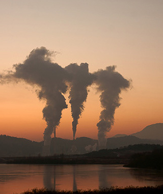
Global Warming Record Down To The Wire. Earthweek.com reports that 2010 is running nearly 1 degree F. warmer than the 1961-1990 average - and will probably tie 1998 for the warmest year on record, worldwide, since 1850. Details
here.
*
From Copenhagen to Cancun. An editorial in the New York Times
here.
National Geographic reports on a recent finding from NASA and JPL. Here is an excerpt from the
article: "
A loss of oxygen and the deterioration of food chains have transformed Africa’s Lake Tanganyika and Russia’s Lake Baikal. Scientists have pointed to global warming, and now a new study finds that a similar fate may be in store for many of the world's freshwater bodies. In the last 25 years, the world's largest lakes have been steadily warming, confirms the new study, some by as much as 4°F (2.2°C). In some cases that is seven times faster than air temperatures have risen over the same period. It's an important find, scientists say, because lake ecology can be extremely temperature-sensitive. "A small change in temperature can have quite a dramatic effect."


No comments:
Post a Comment