Storm Headlines:
*
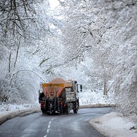
Chance of significant snowfall has diminished a bit today, leaning toward a coating, mixed with freezing drizzle at times. Afternoon highs near 30 should mean wet/slushy interstates/freeways -
side streets and bridges may become icy. I'm more concerned about icing today than accumulating snow. Freeways/interstates may be wet/slushy, but side streets and bridges may become very icy by midday/afternoon.
* Brief break in the action Friday as temperatures fall through the 20s.
*
Second, much more significant snowfall late Friday night into Saturday. Unlike today's wet, slushy (icy) snowfall, Saturday's snow will be dry/powdery/fluffy - quick to accumulate, prone to blowing and drifting by afternoon and evening, especially outside the metro area.
Potential for over 12" close to home.
*
Dangerously cold weather arrives over the weekend - wind chills dip into the -20 to -35 range by Saturday night and Sunday. Highs will not climb above zero across much of Minnesota Sunday and Monday, including the metro area.
* I realize this is Minnesota - the locals know how to dress/adapt for bitter cold, but it's worth repeating:
the risk of frostbite and hypothermia (gradual drop in body temperature) will be very high from late Saturday into midday Monday. Plan on checking in with older friends, family and neighbors to make sure their homes/apartments are staying warm enough. Symptoms of hypothermia include uncontrollable shivering, disorientation and "gibberish" - if you suspect hypothermia call 911 immediately.
 Latest Model Guidance
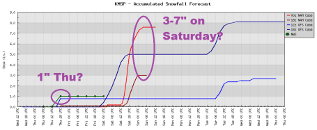
. The 12z NAM/WRF model prints out close to an inch of liquid precipitation Saturday with a snow/rain ratio expected to be somewhere between 15/1 and 20/1. That could translate into as much as 1 to 2 FEET of snow for MSP by Saturday night. Sustained winds are forecast to be 23 mph. by 6 pm Saturday - meaning (in reality) winds may be in the 25-35 mph range, close to blizzard criteria. I'm not predicting a blizzard yet, but each passing run looks more impressive in terms of snow and wind. It's unclear where the heaviest snow bands will set up, but there is little doubt that a major snowstorm will create a fair amount of havoc Saturday, followed by the coldest December day in 2 years.
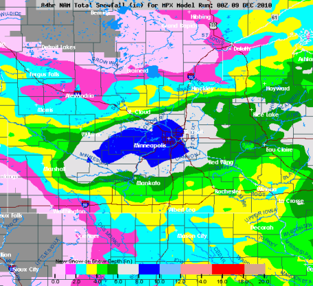
Significant Saturday Snowfall? Don't panic - this map shows expected snowfall between today and Sunday morning - a band of 8" over the MSP metro area? MOST of this snow is expected to fall Friday night into Saturday, on the leading edge of the next (blistering) Arctic airmass. Saturday's snow will be light, fluffy, powdery - quick to accumulate, like air puffing up a featherbed. Winds may reach 20-25 mph Saturday night, producing significant blowing and drifting, along with a wind chill as cold as -15 to -25.
Potentially Plowable. The faster the jet stream winds howling overhead - the faster the weather changes - the more unpredictable the 7-Day Outlook. In fact the 48 Hour Outlook can be incredibly challenging when steering winds aloft are howling at 100-150 mph. It now looks like a coating to an inch of slushy snow today, but
the MAIN snow event is shaping up for Saturday, as the Arctic air finally spills south of the border.
It may be a significant pile of snow, as much as 3-6", with a few 8" amounts possible close to the metro area.
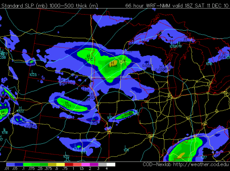
Saturday Snow. I want to see a few more model runs, but the latest guidance is hinting at a "plowable" snowfall Saturday across much of central and southern MN, the heaviest amounts south of St. Cloud and Mille Lacs. The map above is the NAM model valid 6 pm Saturday evening, showing accumulated snow the previous 6 hours. An inverted trough, a wave of low pressure passing off to the south, will provide enough "lift" for 5-8 hours of light, fluffy, powdery snow.
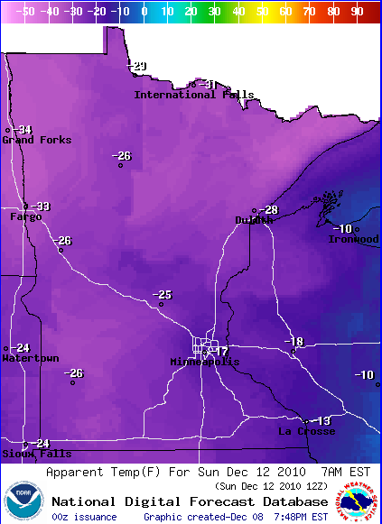
Sunday Wind Chill. Here is the NWS prediction for the wind chill 7 am Sunday morning, ranging from -17 in the Twin Cities to -25 at St. Cloud to a brisk -33 at Fargo. Check out NOAA's interactive forecast capabilities
here.
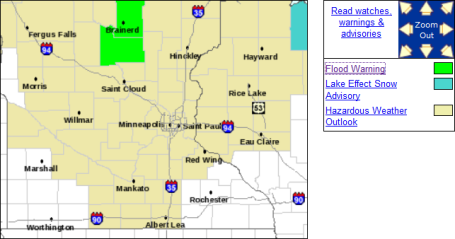
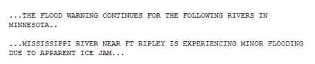
Flood Warning: The NWS reports flooding on the Mississippi River near Ft. Ripley. For more information click
here.
"Too Cold To Snow?" I'm not a fan of that expression, although there is a kernel of truth to this old proverb. Our biggest snowstorms come when the temperature is between 20-30 F. When the mercury is colder than roughly 15 F it usually means the storm track is too far south/east of Minnesota for much more than flurries and snow showers capable of a coating here, an inch there. That will be the story next week - bitterly cold air engulfing Minnesota, shoving the main highway for storms 300-500 miles south/east, significant snow possible as close as Des Moines, Chhicago and Detroit. For more check out Larry Cosgrove's excellent "Examiner" weather
blog.
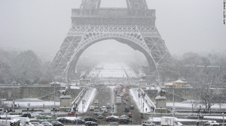
Wintry Weather Disrupts Travel In Paris Region. Enough snow to close the Eiffel Tower in Paris? Believe it. What a mess. At last report: 4" in Paris, and still snowing lightly. An excerpt from a
story at CNN: "
Heavy snow paralyzed travel in the Paris region Wednesday, where officials suspended air traffic at one of Europe's busiest airports, closed several highways and shut down the Eiffel Tower. The resulting traffic jams set a new record. According to the National Center for Highway Information, snarled traffic lined 420 kilometers of roadways around the capital. Officials at the Charles de Gaulle airport suspended air traffic for several hours in the afternoon, and began limited operations in the evening, according to Aeroports de Paris, the region's airport authority. There were dozens of flight cancellations and there will be long delays for other flights, authorities said. At the Orly airport, several flights were canceled and delays were running up to three hours, the airport authority said on its website. Météo France has issued an "orange" weather warning across central France, the second-highest level of warning. As much as 10-15 centimeters of snow has fallen in some areas, and forecasters are predicting 2 to 3 more centimeters will come down before Thursday."
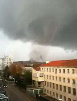
. This time it's a YouTube
clip showing an apparent touchdown in Portugal. Very odd to see tornadoes - in Europe - in December?
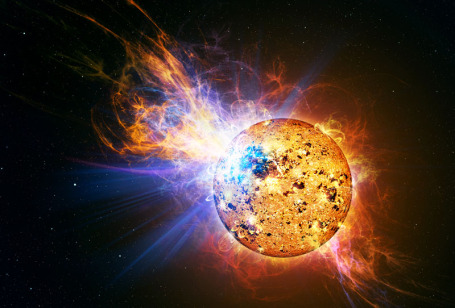
33% of Sun's Blasts Are Sneak Attacks With Little Warning. Predicting a solar flare is the rough equivalent of warning for a tornado - minutes of lead time, not hours or days. From a fascinating
article at syfy.com: "
Astronomers have revealed that one-third of the Sun's blasts are "sneak attacks" that may occur without warning. "If space weather forecasters rely on some of the traditional danger signs, they'll miss a significant fraction of solar eruptions," said Suli Ma of the Harvard-Smithsonian Center for Astrophysics (CfA). Ma and her colleagues studied 34 solar eruptions over 8 months using the STEREO spacecraft, which allows us to study the Sun from two different angles simultaneously."
Breaking The Ice Before It Begins. Older Minnesotans don't hate the snow and cold, as much as they HATE the risk of ice. All it takes is one bad spill on an icy sidewalk or driveway to break a hip, wind up in the hospital, where things can go from bad to worse. I get it. What if we could (truly) lower the risk of severe icing? I saw an eye-opening segment on CNN Wednesday and was frankly amazed - a new material that repels ice. The implications are enormous - especially for northern, ice-prone latitude from Boston to Minneapolis. A few details from the Harvard
story: "
Engineers from Harvard University have designed and demonstrated ice-free nanostructured materials that literally repel water droplets before they even have the chance to freeze. The finding, reported online in ACS Nano on November 9th, could lead to a new way to keep airplane wings, buildings, powerlines, and even entire highways free of ice during the worst winter weather. Moreover, integrating anti-ice technology right into a material is more efficient and sustainable than conventional solutions like chemical sprays, salt, and heating. A team led by Joanna Aizenberg, Amy Smith Berylson Professor of Materials Science at the Harvard School of Engineering and Applied Sciences (SEAS) and a Core Member of the Wyss Institute for Biologically Inspired Engineering at Harvard, focused on preventing rather than fighting ice buildup."
H1N1 Vaccine Linked To 700% Increase in Miscarriage. Granted, this
article has nothing to do with weather, but it did catch my eye. An excerpt: "
(NaturalNews) Recent data presented to the U.S. Centers for Disease Control and Prevention's (CDC) Advisory Committee on Children's Vaccines has revealed some shocking information about the effects of the H1N1 / swine flu vaccine on pregnant women. According to the report, the rate of miscarriage among pregnant women during the 2009 H1N1 / swine flu pandemic soared by over 700 percent compared to previous years, pointing directly to the vaccine as the culprit -- but the CDC denies the truth and continues to insist nobody has been harmed. According to the CDC, nearly 50 percent of all pregnant women were vaccinated with the H1N1 vaccine during the 2009 / 2010 influenza season. Those whose physicians instructed them to get a seasonal flu shot were three times more likely to get it, while those instructed specifically to get the H1N1 shot were ten times more likely to get it. And the numbers clearly show that along with the rise in vaccinations due to the H1N1 scare came the sharp increase in miscarriages, including a slew of actual reported adverse events."
On A Lighter Note....
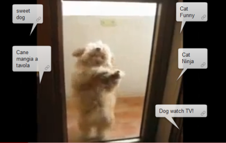 "Before We Go"
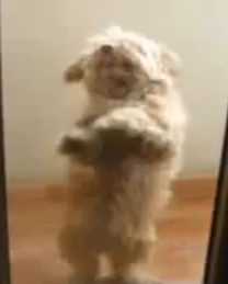
. No water-skiing squirrels, but I do have a dog dancing the salsa.
This is one talented dog, courtesy of YouTube. Who knew that dogs could dance?
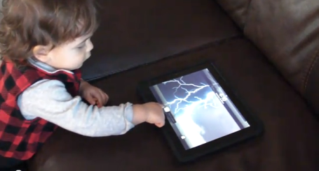
Toddlers Like The iPad Too. This is Crosby Nelson, 17 month old son of WeatherNation meteorologist Todd Nelson, one of the very first meteorologists to join our team (which now numbers 8 - the largest on-air staff in Minnesota). Todd is VERY prolific with computers, gadgets and gizmos, and apparently some of that DNA got handed down to his firstborn son. I'm embarrassed to admit this, but Crosby does a better job manipulating the iPad than I do. Smoked by a 17 month old! See for yourself
here.
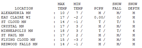
Wednesday Stats. Temperatures were as much as 8-12 degrees colder than average across the state yesterday with a trace of flurries in St. Cloud and the Twin Cities. December temperatures are running 8 F. colder than average in the Twin Cities.
Paul's Conservation MN Outlook for the Twin Cities and all of Minnesota:
TODAY: Cloudy with a little snow and freezing drizzle which will ice up some roads. Coating to 1/2" possible Winds: SW 10-20. High: near 30
THURSDAY NIGHT: Light snow and freezing drizzle, coating to an inch possible. Low: 18
FRIDAY: Mostly cloudy, colder. More light snow possible Friday night. High: 25
* SATURDAY: Over a foot of powdery snow with treacherous travel and near-blizzard conditions by afternoon/evening. Bitter winds, falling temperatures. High: 12 (falling during the day). Wind chills reach -25 by Saturday night with significant blowing and drifting.
SATURDAY NIGHT: Flurries taper - wind chill dipping to -25 at times. Low: -8
SUNDAY: Fresh Yukon sunshine! Wind chill: -25. High: 2 (subzero highs over much of Minnesota).
MONDAY: Blue sky. "Character-building". Low: -10. High: 5
TUESDAY: 1-2" snow possible. Not as bitter. High: 14
WEDNESDAY: Some sun, not quite as numbing. High: near 20
Coming Cold Wave
By Sunday your goosebumps will have goosebumps. "Why is it so cold, so early?" my oldest son, Walt, asked me yesterday. "This just feels wrong - it's not even winter yet!" I feel your pain. The reality: "meteorological winter", marking the start of the coldest 90 days of the year, really kicked off on December 1. December is running 8 degrees colder than average. As far as the atmosphere is concerned, we've just fast-forwarded into January. Unusual but not unprecedented. December 10, 2009 the high was 5 F. December 15, 2008 the high was a crisp -1, after waking up to -10F.
This reminds me of 2000, when we muddled through 14 subzero lows in December, only to see temperatures rebound in January, with only 6 subzero lows and 14 days in the 30s. Can I promise that? No. But history has a way of repeating itself.
Today's clipper drops a coating of (icy) snow, highs near 30 keeping some freeways wet PM hours. The approach of Siberian air (no exaggeration) this weekend may squeeze out over a FOOT of powder Saturday with near-blizzard conditions outside the metro. By Sunday wind chills dip to -30 or colder with a high holding below zero, even in the metro area. This may be the coldest December in a decade; single digit highs on Christmas Day? Think warm thoughts. January will be here soon.
100 Perfect Gifts - Whether You've Been Naughty Or Nice. Wired magazine (a favorite of mine) has their annual list of the best gifts for techies - a few good ideas
here.
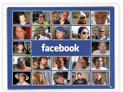
Has Facebook Jumped The Shark? "Dad, when Facebook allowed all the (old people) to join - it ruined the service for me," my oldest son remarked the other day. Hey, my mom's on Facebook! It's a hilarious
skit on SNL, but because anyone and everyone can now jump on FB has it lost some of its cool factor. An interesting
observation from Judy Shapiro at adage.com:
"
I knew I was on thin ice when a close friend who is CEO of a tech company cautioned me: "It will get attention, and people will call it BS, and I will be one of them." It was a sobering comment echoed by the folks at Ad Age when they gently suggested I better have a damn good argument as claiming that Facebook has "jumped the shark" was likely to be "controversial."
So let me say from the get-go that my only goal here is to understand the best use of Facebook -- you can't use Facebook well if you don't know what Facebook does well. I have no axe to grind with Facebook but I hold no sacred cows either. The rapid growth of Facebook over the last 18 months requires thoughtful marketers to consider this question given its ascent to the equivalent of the 900-pound marketing gorilla of the social-media world."
The Scientific Guide To Global Warming Skepticism. It's unusual to come across a web site that has taken the time to truly vet the science and try to distinguish peer-reviewed fact from blog-conjecture, dogma and ideology. This site makes the following claim: "
Scientific skepticism is healthy. In fact, science by its very nature is skeptical. Genuine skepticism means considering the full body of evidence before coming to a conclusion. However, when you take a close look at arguments expressing climate ‘skepticism’, what you often observe is cherry picking of pieces of evidence while rejecting any data that don’t fit the desired picture. This isn’t skepticism. It is ignoring facts and the science. The Scientific Guide to Global Warming Skepticism looks at both the evidence that human activity is causing global warming and the ways that climate ‘skeptic’ arguments can mislead by presenting only small pieces of the puzzle rather than the full picture."
Scientist: Fire In Israel Is A Typical Example Of Climate Change In The Mediterranean Region. An
article from physorg.com, focused on the recent (and deadly) brushfire that swept across northern Israel:
"The fire disaster in the Carmel Mountains near Haifa is a typical example of climate change effect and a taste of the future, says Dr. Guy Pe'er, one of the authors of Israel's first report to the UN on climate change. Ten years ago, Dr. Pe'er and other Israeli scientists collated knowledge about the effects of climate change for Israel. They warned already in the year 2000 of expected climatic fluctuations, heat events, decreased rainfall and delayed late winter rainfall, all of which would lead to increased risk of intense forest fires."
Journalistic Scuffle Over Climate Science. It seems there's a fair amount of media finger-pointing in the British press over the topic of climate science. The Daily Mail's David Rose wrote a series of articles about climate change which (according to his detractors) simply don't hold up - they're not based on peer-reviewed science, but rather some "dodgy sources." How journalists cover the complicated topic of climate change is going to be very important going forward - not resorting to tabloid reporting but basing an ongoing discussion on solid science that has been vetted by reliable peer-reviewed sources. An excerpt from an
article in the U.K. Guardian: "
You can divide people into two categories: those who learn from their mistakes and those who don't. There is no third category: we all mess up from time to time. Journalism is a mistake waiting to happen. With tight deadlines, big rewards for shock and awe and small rewards for methodical, less spectacular work, with an inverse relationship between volume and truth in public life, reporters tend to stumble from one accident to another. The only hope journalists have of retaining any kind of self-respect is to question themselves repeatedly, ask whether they are being manipulated and whether they are seeing the whole story. So where does this leave David Rose? I don't want to credit the media with more power than it has, but from time to time it is pivotal to public policy. One such moment was the build-up to the Iraq war. The UK might not have joined Bush's war if it didn't have broad support from the press, and particularly from sections of the liberal press."


No comments:
Post a Comment