* Chance of significant snowfall has diminished a bit today, leaning toward a coating to 1" later, mixed with freezing drizzle. Highs near 30 should mean wet/slushy interstates/freeways - side streets and bridges may become icy.
* Brief break in the action Friday as temperatures fall through the 20s.
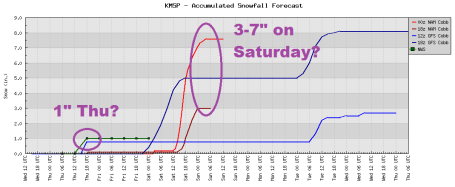
* Second, much more significant snowfall late Friday night into Saturday. Unlike today's wet, slushy (icy) snowfall, Saturday's snow will be dry/powdery/fluffy - quick to accumulate, prone to blowing and drifting by afternoon and evening, especially outside the metro area. Potential for 3-6" with a few 8" amounts possible close to home.
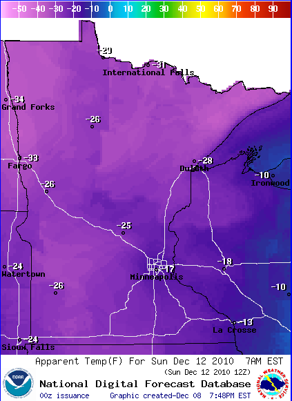
* Dangerously cold weather arrives over the weekend - wind chills dip into the -20 to -35 range by Saturday night and Sunday. Highs may not climb above zero across much of Minnesota Sunday and Monday.
* I realize this is Minnesota - the locals know how to dress/adapt for bitter cold, but it's worth repeating: the risk of frostbite and hypothermia (gradual drop in body temperature) will be very high from late Saturday into midday Monday. Plan on checking in with older friends, family and neighbors to make sure their homes/apartments are staying warm enough. Symptoms of hypothermia include uncontrollable shivering, disorientation and "gibberish" - if you suspect hypothermia call 911 immediately.
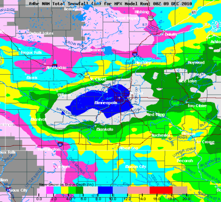
Saturday Snow. I want to see a few more model runs, but the latest guidance is hinting at a "plowable" snowfall Saturday across much of central and southern MN, the heaviest amounts south of St. Cloud and Mille Lacs. The map above is the NAM model valid 6 pm Saturday evening, showing accumulated snow the previous 6 hours. An inverted trough, a wave of low pressure passing off to the south, will provide enough "lift" for 5-8 hours of light, fluffy, powdery snow.
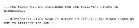
Flood Warning: The NWS reports flooding on the Mississippi River near Ft. Ripley. For more information click here.
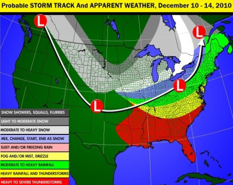
"Too Cold To Snow?" I'm not a fan of that expression, although there is a kernel of truth to this old proverb. Our biggest snowstorms come when the temperature is between 20-30 F. When the mercury is colder than roughly 15 F it usually means the storm track is too far south/east of Minnesota for much more than flurries and snow showers capable of a coating here, an inch there. That will be the story next week - bitterly cold air engulfing Minnesota, shoving the main highway for storms 300-500 miles south/east, significant snow possible as close as Des Moines, Chhicago and Detroit. For more check out Larry Cosgrove's excellent "Examiner" weather blog.
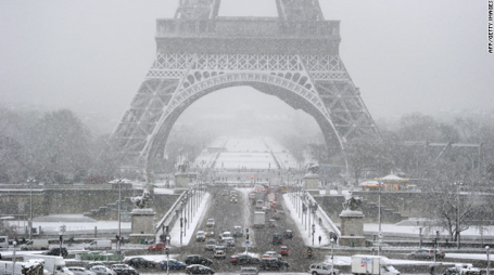
Wintry Weather Disrupts Travel In Paris Region. Enough snow to close the Eiffel Tower in Paris? Believe it. What a mess. An excerpt from a story at CNN: "Heavy snow paralyzed travel in the Paris region Wednesday, where officials suspended air traffic at one of Europe's busiest airports, closed several highways and shut down the Eiffel Tower. The resulting traffic jams set a new record. According to the National Center for Highway Information, snarled traffic lined 420 kilometers of roadways around the capital. Officials at the Charles de Gaulle airport suspended air traffic for several hours in the afternoon, and began limited operations in the evening, according to Aeroports de Paris, the region's airport authority. There were dozens of flight cancellations and there will be long delays for other flights, authorities said. At the Orly airport, several flights were canceled and delays were running up to three hours, the airport authority said on its website. Météo France has issued an "orange" weather warning across central France, the second-highest level of warning. As much as 10-15 centimeters of snow has fallen in some areas, and forecasters are predicting 2 to 3 more centimeters will come down before Thursday."


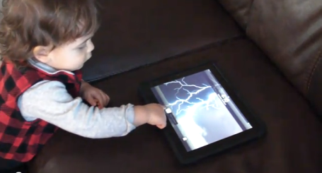
Toddlers Like The iPad Too. This is Crosby Nelson, 17 month old son of WeatherNation meteorologist Todd Nelson, one of the very first meteorologists to join our team (which now numbers 8 - the largest on-air staff in Minnesota). Todd is VERY prolific with computers, gadgets and gizmos, and apparently some of that DNA got handed down to his firstborn son. I'm embarrassed to admit this, but Crosby does a better job manipulating the iPad than I do. Smoked by a 17 month old! See for yourself here.
Paul's Conservation MN Outlook for the Twin Cities and all of Minnesota:
TODAY: Cloudy with a little freezing drizzle which may ice up some roads. Winds: SW 10-20. High: near 30
THURSDAY NIGHT: Light snow and freezing drizzle, coating to an inch possible. Low: 18
FRIDAY: Mostly cloudy, colder. More light snow possible Friday night. High: 25
* SATURDAY: 3-6" powdery snow with potentially treacherous travel. Bitter winds, falling temperatures. High: 12 (falling during the day). Wind chills reach -25 by Saturday night with significant blowing and drifting.
SATURDAY NIGHT: Flurries taper - wind chill dipping to -25 at times. Low: -8
SUNDAY: Fresh Yukon sunshine! Wind chill: -25. High: 2 (subzero highs over much of Minnesota).
MONDAY: Blue sky. "Character-building". Low: -10. High: 5
TUESDAY: 1-2" snow possible. Not as bitter. High: 14
WEDNESDAY: Some sun, not quite as numbing. High: near 20
Coming Cold Wave
By Sunday your goosebumps will have goosebumps. "Why is it so cold, so early?" my oldest son, Walt, asked me yesterday. "This just feels wrong - it's not even winter yet!" I feel your pain. The reality: "meteorological winter", marking the start of the coldest 90 days of the year, really kicked off on December 1. December is running 8 degrees colder than average. As far as the atmosphere is concerned, we've just fast-forwarded into January. Unusual but not unprecedented. December 10, 2009 the high was 5 F. December 15, 2008 the high was a crisp -1, after waking up to -10F.
This reminds me of 2000, when we muddled through 14 subzero lows in December, only to see temperatures rebound in January, with only 6 subzero lows and 14 days in the 30s. Can I promise that? No. But history has a way of repeating itself.
Today's clipper drops 1-3" of slushy (icy) snow, highs near 30 keeping some freeways wet PM hours. The approach of Siberian air (no exaggeration) this weekend may squeeze out 1-2" powder Saturday. By Sunday wind chills dip to -30 or colder. This may be the coldest December in a decade; single digit highs on Christmas Day? Think warm thoughts. January will be here soon.


"I knew I was on thin ice when a close friend who is CEO of a tech company cautioned me: "It will get attention, and people will call it BS, and I will be one of them." It was a sobering comment echoed by the folks at Ad Age when they gently suggested I better have a damn good argument as claiming that Facebook has "jumped the shark" was likely to be "controversial."
So let me say from the get-go that my only goal here is to understand the best use of Facebook -- you can't use Facebook well if you don't know what Facebook does well. I have no axe to grind with Facebook but I hold no sacred cows either. The rapid growth of Facebook over the last 18 months requires thoughtful marketers to consider this question given its ascent to the equivalent of the 900-pound marketing gorilla of the social-media world."


No comments:
Post a Comment