* Cold sun today, no travel problems, the proverbial "calm before the storm."
* No commuting problems Friday morning, but light snow arrives mid/late afternoon Friday, the drive home tomorrow may be slippery.
* Potential for a "plowable" snowfall increasing Friday night, best chance of 5-10" snow south/west of the Twin Cities, but some 4-8" amounts are possible by Saturday morning, especially southern/western suburbs of the Twin Cities.
* Very icy Friday night (MnDOT sand/chemicals don't work nearly as well when temperatures are in the upper teens as they do when the mercury is closer to 32 F). Leave plenty of extra time to get around.
* Slippery start Saturday morning, but sun appears by afternoon - travel should improve as the day goes on.
* Bitterly cold next week, highs mostly in the teens, single digit lows.
* First chance of a thaw? Mid December.
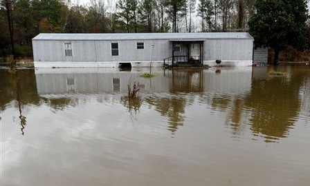
Let's Move To Minnesota! Hey, it's not so bad. How long can you hold your breath? No such thing as bad weather - just inappropriate clothing choices.
The complete story is here.
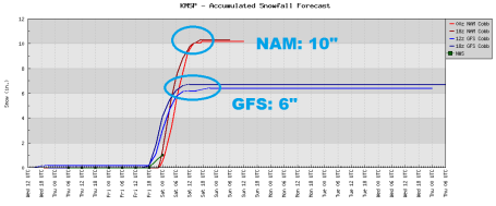
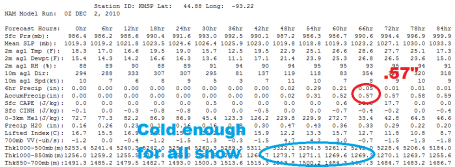
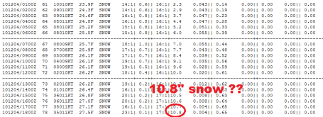
10" Snows? It's too early to get excited (or depressed). This data (from Iowa State University) factors in a snow ratio of close to 20/1 (20" of light, fluffy, powdery snow for every 1" of liquid). So .6" liquid might translate into close to 11" of snow - in a perfect word. But it's still too early to know (for sure) if the heaviest snow bands will set up over the Twin Cities, or shift farther south/west, running from Montevideo and Willmar to Mankato, which is a distinct possibility. Hopefully the models on Thursday will crystallize around a final solution and our confidence levels will increase. Bottom line: a shift of 50-75 miles in the track of Friday's clipper will probably make the difference between a couple inches, and as much as 6-10" of accumulation. Right now it appears the axis of heaviest snow will set up just south/west of MSP, but a slight northward shift to the track of the clipper could bring the heaviest burst of snow right over the metro area.
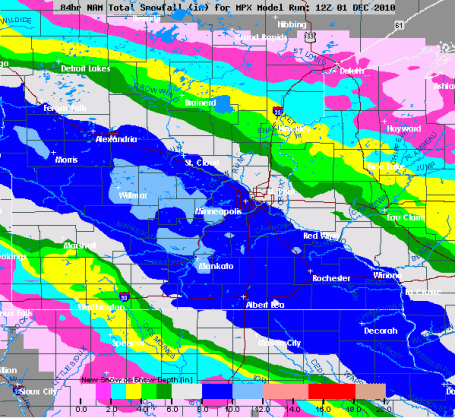
Snowy Bulls-Eye? Right now the NAM/WRF model shows the axis of heaviest snow setting up right over the metro area, running from Morris and Willmar into the southern/western suburbs to Mankato and Rochester, a 75 mile wide band of 8"+ amounts. We'll see. It's by no means a slam-dunk - there's still a good chance the heaviest amounts will stay south/west of the MN River, but there's little doubt we'll see enough snow to shove/plow, a light, powdery, fluffy snow that will be relatively easy to get off your driveway - but with temperatures in the upper teens to low 20s even major highways may become snow-covered Friday night - expect a skating rink out there after dark tomorrow.
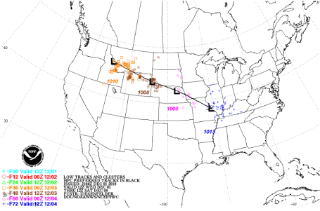
Big Time Clipping? The track of Friday's storm makes me nervous (then again, everything makes me nervous these days). It's fairly far south and west - no question we'll have a deep enough layer of cold air for snow. No question about that. But with a track from Omaha to St. Louis I'm concerned that the heaviest snow bands may set up over far southern MN, we may just be on the northern fringe of the most significant snow. That said, not sure how we see less than 2 or 3", but there's little doubt the best chance of 6"+ will come south/west of MSP.
* The last time we saw above-average snowfall for a winter season here in the Twin Cities? The winter of 2003-2004, when just over 66" fell (average is closer to 50" for the last 30 winters). At the rate we're going I think we may see the first above-average winter for snow in 7 years. Stay tuned.
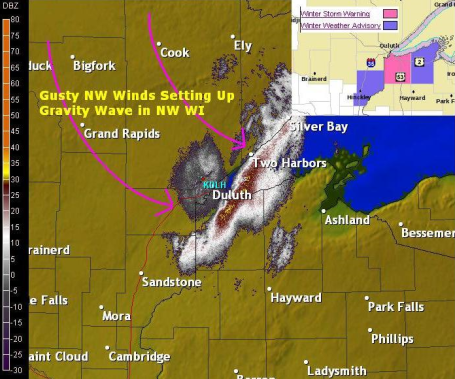
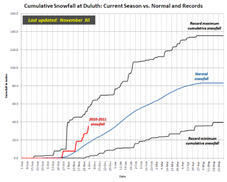
"Gravity Waves". Duluth has picked up 36" of snow so far this winter season, 18.6" more than normal, to date. I'm discovering that much of the (enhanced) snow that is usually attributed to "lake effect" is actually the result of "gravity waves", Rossby waves setting up because of the differences in terrain in the Duluth. With a storm passing off to the south and east of DLH residual moisture + a 1,200 foot difference in elevation can create these "waves" of heavy snow - the most intense squalls often setting up just south/east of downtown Duluth over extreme northwestern Wisconsin. Amazing stuff. WeatherNation meteorologist Todd Nelson has more on gravity waves on the Ham Weather blog here.
* So far in 2010 a total of 13 EF-4 tornadoes have been reported, nationwide. That's the most since 1999.


Has NASA Found Alien Life? Stop the presses. This could be a game-changer. Life on Mars? Intelligent life on Earth? PC Magazine has more details: "NASA has incited the excitement of space camp alums everywhere with the announcement of a Thursday press conference that could discuss findings of life beyond earth. "NASA will hold a news conference at 11 a.m. PST on Thursday, Dec. 2, to discuss an astrobiology finding that will impact the search for evidence of extraterrestrial life," NASA said in a Wednesday statement. "Astrobiology is the study of the origin, evolution, distribution, and future of life in the universe."
TODAY: Intervals of sun, good travel. Winds: NW 10. High: near 20
THURSDAY NIGHT: Partly cloudy and cold. Low: 9
FRIDAY: Dry start, no problems for the AM commute. Light snow develops by late afternoon. High: 22
FRIDAY NIGHT: Snow likely, potentiall tricky travel. Potential for 4-8" snow, more south/west of MSP. Low: 21
SATURDAY: Snow tapers, "plowable" amounts early in the day - better travel by afternoon with some PM sun possible. High: 23
SUNDAY: Sun returns - numbing breeze. High: near 20
MONDAY: Blue sky, Arctic fun!. High: 17
TUESDAY: Cold and quiet, more like January. High: 20
WEDNESDAY: Still waiting on a warm front. Mix of clouds and sun, good travel weather. High: 23
A Real Winter
Does this latest cold, snowy spell disprove the fact that our atmosphere is slowly warming over time? No. Every time it snows, every time a cold front arrives, some people cry "where's your global warming now?" They don't (or won't) grasp the fundamental difference between weather and climate. Weather is CNN Headline News. Climate is the History Channel.
NOAA and NASA insist that, worldwide, 2010 will tie 1998 for the warmest year on record, globally. For the sake of my kids I hope the scientists are wrong. Time will tell.
Brian Westberg wants to know the difference between the winter solstice and "meteorological winter." Historically the coldest 90 day period starts December 1. So in reality, winter really kicks off in early December, not the 21st. No kidding?No travel problems today, but computer models show another "plowable" snow moving in Friday PM hours, the best chance of 4-8" south and west of the Twin Cities by Saturday morning. It may be a close call. If you plan on traveling late Friday or early Saturday check the blog for the latest. Another Arctic treat arrives behind the storm next week; at this rate odds favor a VERY "white" Christmas this year. Count on it.

For Russia, Global Warming Benefits Outweigh Risks. Yes, there will be benefits to a warmer world, no question. An excerpt from an article in the Moscow Times: "Global warming in the next 40 years will allow Russian authorities to save on central heating, increase agricultural production and extend sea navigation in the north, a leading Russian climatologist told a Russian-German conference Wednesday. But authorities will have to fork out money to reconstruct several big Siberian and Far Eastern cities to prevent them from collapsing as a result of a warmer climate, Vladimir Klimenko, head of Laboratory of Global Power Engineering Problems at the Moscow Power Engineering Institute told the conference co-organized by Alexander von Humbolt Foundation. However, "the reduction of heating alone outweighs all the negative results [of the global warming] by many times," Klimenko said. If the money saved through reducing heating "is spent sensibly, then something can be achieved," he said."
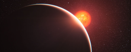
First "Super-Earth" Atmosphere Analysed. From an article at eso.org: "The atmosphere around a super-Earth exoplanet has been analysed for the first time by an international team of astronomers using ESO’s Very Large Telescope. The planet, which is known as GJ 1214b, was studied as it passed in front of its parent star and some of the starlight passed through the planet’s atmosphere. We now know that the atmosphere is either mostly water in the form of steam or is dominated by thick clouds or hazes. The results will appear in the 2 December 2010 issue of the journal Nature."
No comments:
Post a Comment