* No travel problems today - intervals of sun, highs in the upper teens to near 20.
* Mix of light snow and freezing drizzle may ice up roads Thursday, potential for a coating to an inch or two (more north/east of town).
* Another "burst" of powdery snow possible late Friday into Saturday morning, a couple more inches of fluff possible.
* Tumbling temperatures over the weekend, falling through the teens Saturday - single digit highs Sunday and Monday.
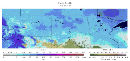
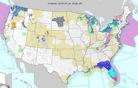
Snow Depth. NOAA's National Snow Analyses shows 5-10" of snow on the ground across much of Minnesota, as much as 10-20" of base up north over the Arrowhead. Things are finally looking up for winter weather enthusiasts. No significant thaws are brewing, so whatever snow is in your yard will still be there for Christmas. The latest observations are
here.
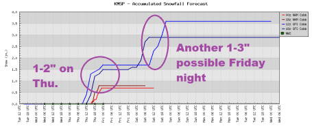
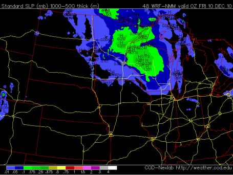
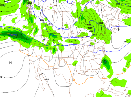
Two Bursts Of Snow? The models are hinting at close to 1" of (slushy/icy) snow on Thursday, a little freezing drizzle mixing in with the snow at times, producing possible glaze icing. A second surge of (dry/powdery) snow arrives Friday night and early Saturday as the main surge of Arctic air arrives, possibly another 1-3" of snow.
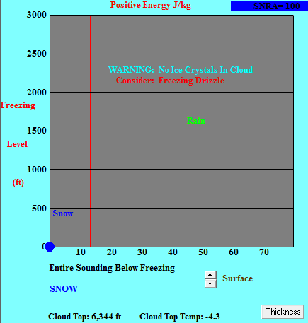
Ice Potential Thursday? The latest KMSP Bufkit sounding prediction shows a thin layer of warm air aloft capable of sparking a little freezing drizzle, especially afternoon hours Thursday. I could see a period of glaze ice developing around the metro, icing up secondary roads, ramps and bridges. Hopefully we'll be close enough to freezing tomorrow to keep freeways mostly wet and slushy.
Thursday Details. The best chance of accumulating snow tomorrow will come north and northeast of MSP. Duluth, Aitkin, Hayward and Spooner may see closer to 2-4" of snow. I'm still concerned about a little freezing drizzle (ice) mixing in here in the metro area - which would keep snowfall amounts lower, while increasing the potential for glaze ice. I expect Thursday highs to be close to 30 F in the metro area, meaning mostly-wet interstates and freeways, but side streets and bridges may be very icy.
Friday Night "Burst". I realize the GFS solution doesn't look terribly impressive, but when it's this cold (teens) it won't take much moisture and upward motion to squeeze out a quick inch or two of fluff. I'm not as confident about Friday night's snow event - want to see a few more model runs.
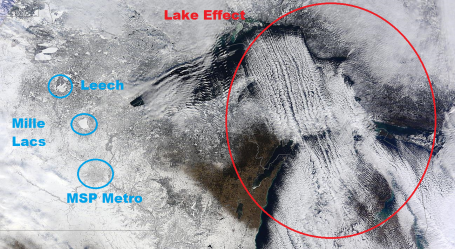
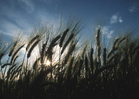
Lake Effect. NASA's Modis "Terra" low-orbiting satellite showed a spectacular example of lake effect snows streaming off of Lake Superior and Lake Michigan - some downwind communities have picked up 1-3 feet of snow in recent days, as 10-20 degree air passes over lake water temperatures in the mid to upper 30s. Look carefully and you can see the dark gray smudge of the MSP metro area, which appears darker (less snow to reflect back into space). Leech Lake and Mille Lacs are (obviously) completely ice-covered now, and show up as brighter than surround snow cover. For the latest Modis image click
here.
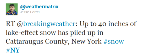
Lake Effect And Florida Freeze. Yes, we may all be paying more for our orange juice and fruit in the coming weeks. Much of central Florida experienced a hard freeze Monday night (defined as 3 hours or more below 28 F - cold enough to kill off most plant life). The mercury sank to freezing in the suburbs of Miami - Naples and Ft. Myers were also impacted by some of the coldest readings in 2 decades. Icy winds passing over the relatively warm Great Lakes are creating vigorous lake effect snows - warnings in effect for the suburbs of Chicago (South Bend), Cleveland, Buffalo, Rochester and Syracuse for another 1 to 2 FEET of snow by midweek. The latest NOAA warnings are
here.
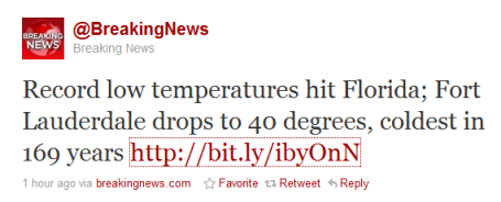
Record Cold. Members of the swim team from Carleton College in Northfield, Minn., swim laps as steam rises from the pool at the Fort Lauderdale Aquatics Center, Tuesday, Dec. 7.
(Joe Cavaretta, Sun Sentinel / December 7, 2010)
Misery loves company. We're freezing up north - that same Arctic airmass is engulfing much of America east of the Rockies - even Florida is feeling the pain. From SunSentinel.com:
South Floridians woke up Tuesday morning to temperatures hovering around the very low 40s that sometimes felt like the mid-30s because of the wind chill factor. "
In Fort Lauderdale, a low temperature record of 42 degrees for Dec. 7 that had been in place for 169 years was broken, said Dan Gregoria, a meteorologist with the National Weather Service in Miami." The entire article is
here - read it and be glad you didn't take the family to Florida THIS WEEK!
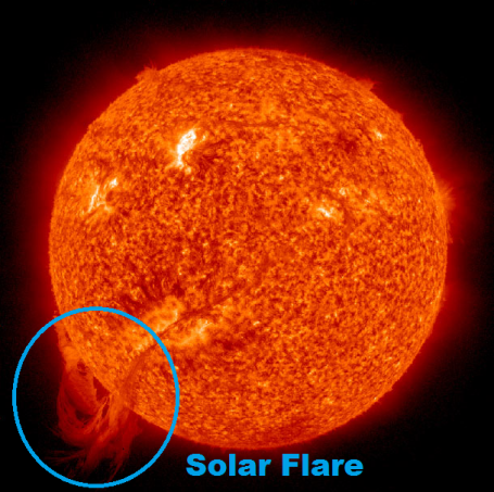
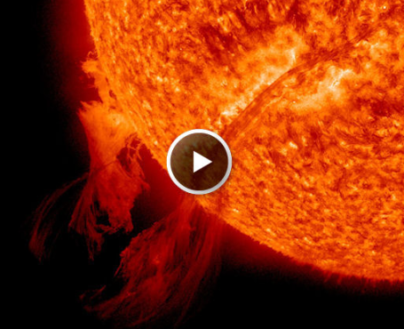
Huge "Looping Prominence" On The Sun. Yes, things are really heating up on the sun. Thanks folks - you've been a great audience, please remember the 2 drink minimum. But seriously - Discover Magazine has a
blog post about a massive solar prominence (flare) on the surface of the sun.
"First, there is very little danger to Earth from this event. Prominences like this tend to be local to the Sun, and collapse after a few hours. As far as I can tell, there are no flares or coronal mass ejections associated with this, which are what can hurt satellites and power grids here at home. So rest easy, and enjoy the beauty of this thing."
Solar Video. Looking to kill a few more minutes? Check out this
video clip from spaceweather.com showing the 700,000 mile long solar prominence erupting from the surface of the sun. Amazing.
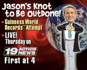
Cleveland Meteorologist Attempting To Set World Record. From "Shoptalk": "
TV news personalities have a reputation for being clotheshorses but WOIO meteorologist Jason Handman is taking it one step further as he attempts to set a new Guinness World Record. The fresh-faced weathercaster is attempting to set the record for most neckties worn at one time and his effort will be broadcast live on Thursday by the CBS-affiliate. Handman needs to reach 50 neckties to set the record but he's planning to shatter that figure. "I anticipate going for well over a 100," Handman says. "I intend to bring home a solid win for Cleveland, one Windsor knot at a time." Handman joined Cleveland's WOIO-WUAB in October 2009 and currently serves as the station's weekday morning meteorologist. He came to the station from AccuWeather, where he did weather reports for Bloomberg as well as local stations across the country. WOIO plans to carry Handman's attempt at worldwide necktie fame during its afternoon newscasts, checking in with him every half hour between 4 p.m. and 6 p.m." I would love to attempt the same thing with my startribune.com videos, only instead of ties my idea is long underwear. Somehow that seems more Minnesotan....more "fitting". Sorry. I think I've been standing too close to the Doppler.
Best Holiday Gifts For Weather Enthusiasts? Is there a weather geek in your life? No - consider yourself blessed. A number of people have asked me for Christmas and Hanukkah gift ideas for "weather enthusiasts" (yes, that has a nicer ring). Top of the list, in my humble opinion: the
RadarScope app for iPhone. Sorry, no Android version yet. The My-Cast "
OneLook" and "
Pilot My-Cast" apps are also phenomenal (my old company, now owned by Garmin, but there are still best-of-breed). And they ARE available on Android. If you're looking for a great home weather station you can't go wrong with La Crosse Technology, just down the road in La Crosse, WI. You get a LOT of bang for the buck with these systems, and they come in all price ranges - the higher end versions have wireless capabilities so you can place your sensors outside, measure everything from rainfall to wind speed (over time) and track these changes on your Mac or PC. Very cool. To see the La Crosse options click
here. For more (general) ideas about great gifts for the weather-fanatic in your household click
here.
Numbing Sunlight. In spite of sunshine much of the day temperatures were stuck in the teens across much of Minnesota on Tuesday. The afternoon high in the Twin Cities was only 17 (normal high is 29). Oh to be normal again. The only day of above normal temperatures this week: Thursday, out ahead of the next fast-moving clipper. Both St. Cloud and the Twin Cities report 6" of snow on the ground.
Paul's Conservation MN Outlook for the Twin Cities and all of Minnesota:
TODAY: Intervals of sun, good travel. Winds: E 3-8. High: 18
WEDNESDAY NIGHT: Clouds increase/thicken. Low: 12
THURSDAY: Next clipper arrives. Coating of snow, freezing drizzle may mix in to produce icy roads. High: 30
FRIDAY: Light snow arrives late. High: 25
SATURDAY: Snowy burst? Couple inches possible, especially south of MSP. High: 16 (falling)
SUNDAY: Frigid. Bright (ineffective) sunshine. Call your travel agent. Low: -3. High: 7
MONDAY: Blue sky, suddent urge to hibernate until April. Low: -6 High: 9
TUESDAY: Clouds, few flurries, not quite as bitter. High: 19
Aerobic Shivering
Is it possible to lose weight because you're shivering uncontrollably? That's one tough way to work off pounds. Surprisingly traction on snow IMPROVES the colder it gets. The worst traction occurs between 30-32 F, when liquid water "lubricates" the snow. Our bodies do not adjust well to dropping temperatures. Most people have seizures when their core body temperature falls below 85; below 82 F their hearts usually stop altogether. Not good. Dressing in layers traps warm air (a great insulator) near your body; far more effective than one big overcoat. By the way, at -20 F motor oil becomes a thick gel, making it much harder on your engine. At -30 F most piston-engine airplanes are grounded, at -40 F exposed flesh can freeze within 60 seconds. Great party trivia - thanks Paul.
No travel headaches today, but freezing drizzle may mix with wet snow tomorrow, a coating to an inch possible. Enjoy Thursday's balmy 30-degree high, because single-digit highs are likely early next week with a string of subzero lows. Hello January. The arrival of this Saskatchewan Slap may set off a burst of powder Saturday, an inch or two for southern MN, more south of Minnesota. The blog has more updates.
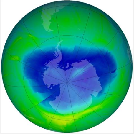
Antarctic Ozone Hole Smallest In Years. From Anthony Watt's
blog (and MSNBC), a little good news for a change:
WELLINGTON, New Zealand — International efforts to phase out the use of chlorofluorocarbons and other ozone-depleting substances may be paying off, according to research revealed Friday by the National Institute of Water and Atmospheric Research in New Zealand. The Antarctica ozone hole is the smallest it has been in the past five years, NIWA said. While a one-year reduction in the ozone hole can’t indicate a recovery stage, NIWA’s atmospheric experts say the new information adds to a pattern of less severe ozone holes in recent years. Satellite data combined with ground-base measurements, including the Antarctica New Zealand Arrival Heights observatory near Scott Base, show the hole reached a maximum area of about 22 million square kilometers (about 8.5 million square miles) and a 27 million ton deficit of ozone this year, compared with 24 million square kilometers (about 9.3 million square miles) and a 35 million ton deficit last year.
The Biggest Obstacles To A Climate Are Overwhelm and Emotional Disconnect. An interesting post from greenmedianews.com, one that gets to the core of the current climate conundrum: consumers are overwhelmed - and unless they feel an emotional attachment to a particular issue they will ignore it as long as possible. So it goes with climate change, a slow-motion transformation, one that will impact the poorest nations first. An excerpt from the
post: "
Finding: There is an emotional disconnect between the language of the climate movement and its underlying drivers. This emotional disconnect is the single greatest obstacle to reaching a climate deal because when you look at the language of the movement, it becomes immediately and crystal clear why there is no global consensus for action: without emotional currency driving a movement for change, there is no real motivation for change.
Here’s an example of how a climate refugee might describe their experience with climate change:
I’m scared and hungry. My parents were killed in the flood. Somehow I survived. But there is no one to take care of me. All my friends are gone. My pet is gone too. I have nothing. The government says we don’t have enough money to rebuild and we have to move. All of us… my whole village. It’s so crowded in the refugee camps. There are many thousands of us. Where shall we go now? Is this the rest of my life, in this refugee camp now? Someone please tell me how I can get out of this mess. I have dreams for my life and my future. Are my dreams going to die? Am I going to be a refugee forever?
But here’s how we talk about climate change in the UNFCCC process:
We must make advances on issues such as mitigation and adaptation. We must come to agreement on REDD as part of a balanced package that includes compromise on all sides. Hopefully if participating nations are willing to compromise on important issues, progress to a balanced package can be made."
 NASA: More Plant Growth Could Slow Global Warming
. From an AFP article late Tuesday:
"
In a world with twice as much carbon dioxide in the atmosphere, plants could grow larger and create a cooling effect on a warming globe, but could not halt or reverse climate change, NASA said Tuesday. One of the main mysteries scientists face with climate change is how to project it over time, particularly how to account for Earth's reaction to warmer temperatures, a phenomenon known as "feedback." It has long been known that plants -- which use carbon dioxide, sun and water to grow through the process of photosynthesis -- are able to adapt to higher carbon dioxide levels by using nutrients more efficiently and growing bigger leaves."The process is called 'down-regulation.' This more efficient use of water and nutrients has been observed in experimental studies and can ultimately lead to increased leaf growth."
Climate Change May Impact Crop Variety. I stumbled upon an interesting article at (of all places) laboratoryequipment.com. What, you don't frequent that site? Neither do I, but through the magic of Google Searchwords the story came to me. An excerpt from the
article: "
Midwest farmers could get a permanent dose of southern-style weather if future climate change projections are accurate, says a Purdue Univ. agricultural economist. "Rainfall variability with a smaller number of storms over the growing season and more intense storms are things we'll have to watch out for," Doering says. "If this develops - as I believe it will - it will affect us all. "Then there's temperature. One area of concern is warmer winters. That might mean pests wouldn't be wiped out as much like on those days in January where it's below zero and the cold permeates the ground. Another important concern with temperature as it relates to corn is pollination. What we'd like to have is a situation where it may be hot in the daytime but there's a drop in nighttime temperatures, which facilitates pollination."
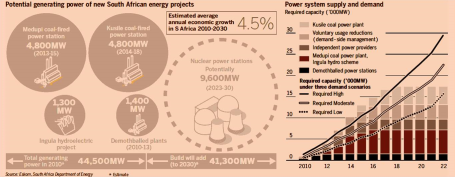
The Energy Challenge In One Figure. Roger Pielke Jr's excellent
blog has an interesting post this morning. Here is an excerpt: "
Last week the FT had a special section on South African Power and Energy. The report included the excellent graphic shown above (click on it to enlarge). The graphic shows that in the very near term -- perhaps in the current decade -- South Africa has a huge gap between what it needs in energy supply and what it currently has planned to meet those needs, which are projected to just about double in the next 20 years or less. South Africa might be considered as representative of the broader global situation, where energy demand growth is being driven by the so-called "developing" countries." The bottom line: South Africa, like every other industrialized nation on the planet, will soon be facing a moment of truth when energy demand will outstrip capacity.

No comments:
Post a Comment