The good news (meteorologically): quiet, cold and dry weather prevails from today through Wednesday, no weather headaches getting home today, and if you're traveling the first half of the week there isn't much to worry about (weatherwise) close to home.
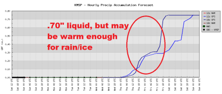
The latter half of the week is a different story: an intensifying storm will send a surge of southern moisture into Minnesota by Thursday, but a layer of relatively mild air aloft could mean rain Thursday into New Year's Eve. With highs in the upper 20s to near 30 it may be just mild enough to keep most freeways/interstates wet late in the week, but I'm still (a little) concerned about a period of icing, freezing rain and drizzle, rain freezing on contact with cold surfaces, especially bridges, secondary roads and side streets outside the metro area.
Models are hinting at a surge of much colder air arriving Friday evening, but by the time it's cold enough for (all) snow a surge of dry air (the dreaded dry tongue) may be cutting off the heaviest precipitation, at least in the metro area. This could still be a "plowable" snowfall for much of northern and western MN, where any changeover to rain/ice will be relatively brief. Bottom line: it's too early for specifics in terms of timing or amounts - but there's little doubt that the weather will once again complicate travel plans later this week.
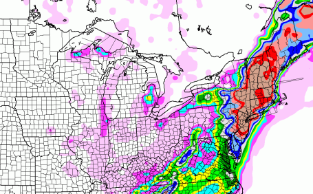
Major Dumping. A classic nor'easter racing up the east coast will draw on Atlantic moisture, dumping 1-2 feet of snow on much of New England. From New Jersey to Boston and interior New England this will easily be the biggest snowfall of the season so far.
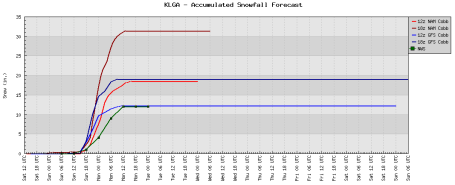
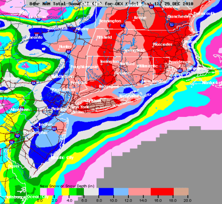
How Much Snow? Larry Cosgrove, a meteorologist I went to Penn State with has an impressive blog at WeatherAmerica. This is Larry's prediction for snowfall amounts from today's nor'easter racing up the east coast.
Richmond VA: 4"
Winchester VA: 4"
Washington DC: 6"
Baltimore MD: 7"
Salisbury MD: 4"
Dover DE: 8"
Wilmington DE: 9"
Philadelphia PA: 10"
Lancaster PA: 5"
Allentown PA: 5"
Easton PA: 8"
Atlantic City NJ: 16"
Trenton NJ: 13"
Newark NJ: 16"
NYC Central Park: 12"
NYC JFK Airport: 16"
Commack LI NY: 18"
Rye NY: 15"
Albany NY: 5"
Bridgeport CT: 17"
New Haven CT: 18"
Hartford CT: 12"
Providence RI: 18"
Boston MA: 17" (Some mixing with rain/sleet south and east sections of metro)
Worcester MA: 12"
Concord NH: 18"
Portland ME: 15" (Some mixing with rain/sleet at height of storm)
St. John NB: 13"
Halifax NS: 8"
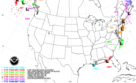
A Perfect Track For Snow. With the storm track staying mostly out to sea, enough cold air should remain in place for mostly snow from Washington D.C. to New York to Portland, Maine.
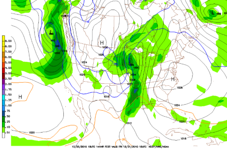
Sloppy New Year's Eve? The GFS model (valid 1 pm Friday afternoon) shows the rain snow line from Grand Rapids to St. Cloud southward to Austin. East of that line there may be just enough warm air aloft for mostly rain (or ice) - the atmosphere potentially cold enough for mostly snow from Sioux Falls and Alexandria to Bemidji and far northern MN.
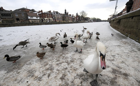
Record Cold Gripping Much Of Europe. Temperatures fell to -17 (C) in Great Britain - rivers are freezing over, flights still being impacted, especially over the U.K. The Daily Mail has an update here.
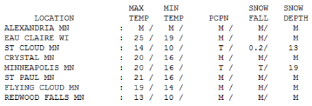
Second Snowiest Christmas Day Since 1891 For MSP. 19" on the ground yesterday with a high of 20 (4 degrees colder than average). St. Cloud is reporting 13" on the ground.
Paul's Conservation MN Outlook for the Twin Cities and all of Minnesota:
TODAY: Partly sunny, good travel. Winds: SE 3-8. High: 16
SUNDAY NIGHT: Clear to partl cloudy. Low: 2
MONDAY: Plenty of sun, not quite as numb. High: 21
TUESDAY: Mix of clouds and sun, dry sky. High: 26
WEDNESDAY: Clouds increase, travel OK. High: 27
THURSDAY: Light rain, possible ice event. High: 29
NEW YEAR'S EVE: Sloppy mix, mostly rain metro area, changing to snow by evening. High: near 30 (falling late).
NEW YEAR'S DAY: Periods of snow, windy and much colder - potential for a couple inches (significantly more possible northern/western MN). High: 18

Christmas Miracle
All I wanted for Christmas this year was my mom. 6 am Christmas Eve, groggy and hungry, responding to the smell of freshly baked cookies, she tumbled down the stairs (walker in hand), breaking her arm, re-injuring her back. A nasty spill for anyone, much less an 81 year old with mild dementia. The saying "you've got your health - you've got everything" is true. It's a miracle she's alive but I am pondering the sweet perils of Christmas cookies.
The days aren't getting any longer (yet), but a freak layer of mild air aloft may tilt a late week storm over to more rain/ice than snow, at least in the metro area. No problems through Wednesday, that's the good news. Light rain streaks in Thursday and New Year's Eve, a potential problem with daytime highs ranging from 25-30; rain may freeze on contact.
A changeover to snow by New Year's Day may pile up a few inches before the storm weakens Sunday - best chance of a "plowable" snowfall northern and western MN. It'll be another busy week on the startribune.com weather blog.
Finally, flying back to New England may be problematic today, a cool 12-15" snow may fall New York to Boston by Monday. Be careful out there. Hug your mom for me.
Oh Man. sorry to hear about your mom's fall! Hope she gets well soon!
ReplyDelete