TODAY: Plenty of sun, breezy. Winds: S 10-15. High: 22
MONDAY NIGHT: Mostly clear, not as cold. Low: 16
TUESDAY: Blue sky, no weather worries. High: 25
WEDNESDAY: Clouds increase, last dry day - milder. High: near 30
THURSDAY: Light rain, some ice outside metro? High: 38
NEW YEAR'S EVE: Rain ends as snow/ice late. High: 36 (falling through the 20s into the teens Friday night).
NEW YEAR'S DAY: Coating of snow possible. Gusty, colder. High: 17
SUNDAY: Better travel, some PM sun. High: 16
Norfolk: 14.2" snow, heaviest since Feb. 17-19, 1989, third heaviest snowfall on record.
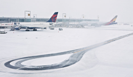
Atlantic City: 15.7" snow as of 10 pm Sunday night. This storm may exceed last year's extreme 18.2" snowfall on Feb. 5-6.
Jacksonville, Florida: Coating of snow reported Sunday, wind chills dipping into the teens.
Columbia, South Carolina: First "white" Christmas since modern-day weather records were first started in 1877.
* Professor Mark Seeley at the University of MN has done research showing a 4-fold increase in rain/ice events across Minnesota during the mid winter months since roughly 2000. Yes, we're seeing more winter rain than we did a generation ago.

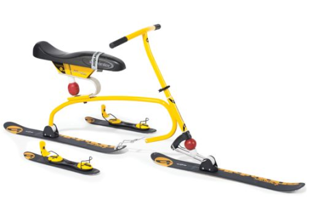
Ultimate Winter Weather Toy? No, it doesn't have any cylinders - totally powered by gravity, but if you're looking for a new and unique way to get down the hill at speeds in excess of 50 mph, consider the "snow cycle" - prominently featured in the latest Hammacher Schlemmer guide. It's designed and built in Austria, and it will only set you back 2K! Right. Thanks Paul. More information here.

Video Games Boost Brain Power, Multitasking Skills. O.K. You may not want to share this article with your 13 year old son. But there's some logic to this story. My youngest son (Brett) loves video games - he has developed amazing eye-hand coordination in recent years, and now he's at the Naval Academy, hoping to fly jets or helicopters. Brett insists all those PS3 games have helped him get to where he is. I have my doubts, but who am I to argue with results? An excerpt from the NPR article: "Parents, the next time you fret that your child is wasting too much time playing video games, consider new research suggesting that video gaming may have real-world benefits for your child's developing brain. Daphne Bavelier is professor of brain and cognitive sciences at the University of Rochester. She studies young people playing action video games. Having now conducted more than 20 studies on the topic, Bavelier says, "It turns out that action video games are far from mindless." Her studies show that video gamers show improved skills in vision, attention and certain aspects of cognition. And these skills are not just gaming skills, but real-world skills. They perform better than non-gamers on certain tests of attention, speed, accuracy, vision and multitasking, says Bavelier."
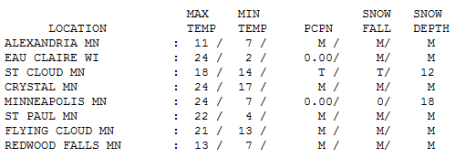
Perfectly Normal. Sunday's high of 24 was the average high for December 26. The snow has compacted/settled a bit, we're down to 18" on the ground in the Twin Cities (MSP International, where cross-country skiing is a bit tricky). St. Cloud is reporting a cool foot on the ground.
Warm Enough For Rain?
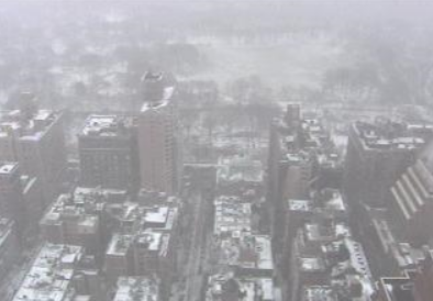
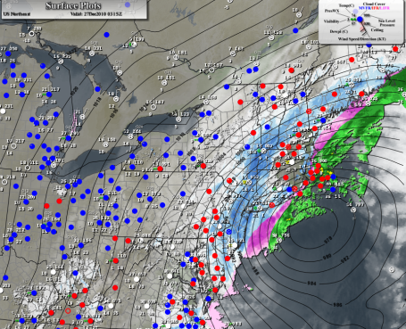
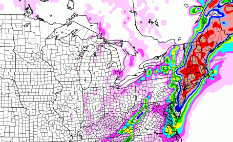
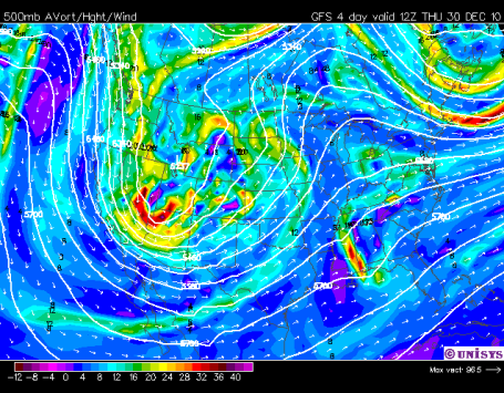
The old saying "may you live in interesting times" came to mind yesterday as I scanned the weather maps. A dusting of snow in Jacksonville, FL? The first white Christmas since 1887 for Columbia, South Carolina? What may turn into the biggest blizzard in 15 years for New England, with 1-2 feet of snow and 6 foot drifts from New York to Boston? Please stop this ride - I'd like to get off.
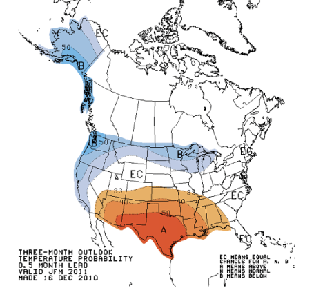
Why so many weather extremes? Water vapor, the "fuel" required by storms, has increased 4-5% in recent decades due to warmer temperatures and enhanced evaporation. This increases the potential for summer floods and more intense winter storms.
Professor Mark Seeley from the U. of MN. has documented a 4X increase in midwinter rain and ice events since 2000 for MSP. Based on the latest maps I expect enough warm air aloft for a cold rain Thursday & New Year's Eve, roads mostly-wet and slushy. By the time it's cold enough for snow (Friday night) most of the moisture will have cut off.
One concern: a rapid temperature drop Friday evening leaving wet roads icy for New Year's Eve festivities. I'll have updates on the weather blog. Quiet into Wednesday; looks like an early January Thaw this year!
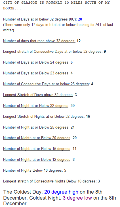
U.K. Weather Stats. Mark Vogan is a friend - and a passionate weather enthusiast based in Glasgow, U.K. He has a fascinating blog that highlights some of the crazy-cold and snowy conditions that have gripped Great Britain in recent days/weeks here.
Bundle Up - It's Global Warming. From an op-ed column in the New York Times: "The earth continues to get warmer, yet it’s feeling a lot colder outside. Over the past few weeks, subzero temperatures in Poland claimed 66 lives; snow arrived in Seattle well before the winter solstice, and fell heavily enough in Minneapolis to make the roof of the Metrodome collapse; and last week blizzards closed Europe’s busiest airports in London and Frankfurt for days, stranding holiday travelers. The snow and record cold have invaded the Eastern United States, with more bad weather predicted. All of this cold was met with perfect comic timing by the release of a World Meteorological Organization reportshowing that 2010 will probably be among the three warmest years on record, and 2001 through 2010 the warmest decade on record. How can we reconcile this? The not-so-obvious short answer is that the overall warming of the atmosphere is actually creating cold-weather extremes. Last winter, too, was exceptionally snowy and cold across the Eastern United States and Eurasia, as were seven of the previous nine winters. For a more detailed explanation, we must turn our attention to the snow in Siberia.."
No comments:
Post a Comment