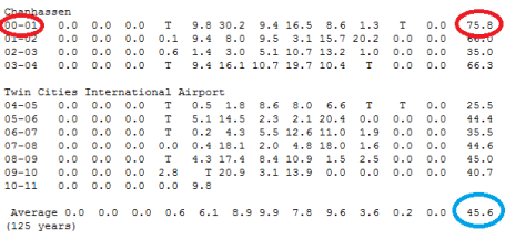
Snowiest Winter In A Decade? I shouldn't rush to conclusions, but you don't have to be a rocket scientist to see which direction this winter is going. We've picked up 24.2" so far in December; we're up to 34" for the winter season so far (that's more than we got during the ENTIRE "winter" of 2004-2005). By Thursday we should have seen more snow than fell during the winter of 2002-2003 (35") and 2006-2007 35.5"). My hunch, at the very least this will wind up being the snowiest winter since 2003-2004 (when 66.3" fell). My gut (nausea?) is that this winter MAY come close to the old fashioned winter of 2000-2001, when nearly 76" fell. Stay tuned. Just a premonition. By the way, the 125 year average winter snowfall for MSP is 45.6" (considerably less than I thought). All the raw data is
here, courtesy of the MN Climate Office.
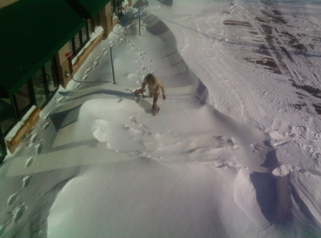
Winter Wasteland. That's WeatherNation meteorologist Gretchen Mishek, attempting to tunnel her way through monstrous, 6 foot drifts outside the front door of our offices in Excelsior. I'm sure you saw the same thing in your yard - some areas swept clean of snow, while a few feet away snow piled up chin-high. The good news: Gretchen was able to reach the front door and get on with her on-air shift.
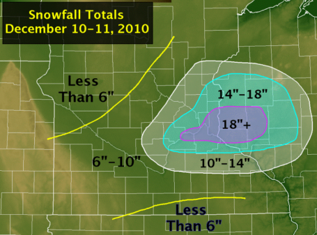
Winter Snowfall In The Twin Cities:
A Rare 1-2 Foot Snowfall. I've been getting e-mails and phone calls from friends around the country. "Hey, I though you guys could handle winter up there - what's the deal with your new outdoor football stadium?" The reality: we're not really accustomed to snowstorms of this magnitude, at least not recently. It was the biggest single-storm total since 1991, a new 2-day snowfall record, according to the National Weather Service. As expected the heaviest bands set up just
south/east of the metro area. From the looks of the extended 15-day (GFS) model that pile of snow isn't going anywhere, anytime soon. This may be the "whitest" Christmas in nearly 2 decades.
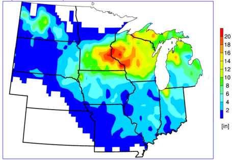
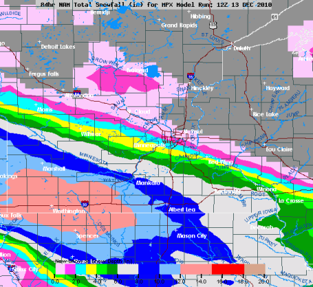
High Resolution Snow Totals. This
map courtesy of the Iowa Environmental Mesonet. Thanks to Jason Parkin for sending me this link.
Here are the top five snowfall totals for a calendar day (24 hour period).
1). 18.5" November 1, 1991
2). 17.2" January 22 1982
3).17.1" January 20 1982
4).16.3" December 11, 2010
5).14.7" March 31, 1985
Snowy Factoid. According to Pete Boulay at the State Climatology Office Saturday's snowy dumping was the 4th greatest (24 hour - single day) snowfall in modern-day history dating back to 1891. Not sure we'll ever bump off the Halloween Superstorm numbers (at least not in our lifetime). That was truly one for the ages. There's now little doubt in my mind that this will turn into the snowiest winter in a decade, and if we exceed 76" by early April (not out of the question at the rate we're going)
this could become the snowiest winter since the winter of '91-92, when 88.1" buried MSP.
A Very Snowy Prediction:
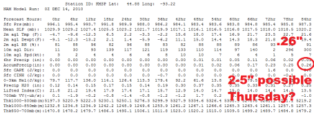
It's dangerous assigning inch amounts to a storm more than 24-36 hours before the snow actually starts to fall. Models are suggesting 2-5" Thursday, another 2-4" next Monday, yet a third accumulating snowfall between December 23-24, possibly a cool half foot close to home.
I predict that the Twin Cities will pick up 35-40" of snow - for just the MONTH OF DECEMBER. That's more than we saw during the entire winter of 2003, 2005 and 2007!
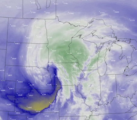
Storm Recap. The University of Wisconsin CIMSS weather blog has a terrific (enhanced infrared) satellite
loop showing the storm winding up over the Upper Midwest - the storm tracking across Iowa, throwing a shield of enhanced snow into the Twin Cities (8 hours/row of heavy snow at MSP at the height of the storm).
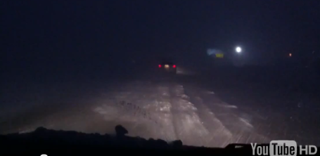
Driving Through A Blizzard. I don't know what's dumber - driving through a blizzard, or videotaping WHILE you're driving through a blizzard. I had second-thoughts about including this clip - don't want to encourage abberant behavior - but this guy (who was driving from Rochester to Pine Island on Highway 52) is just asking for trouble. The YouTube
clip is here, rated R for "really"?
Snowy Bulls-eye. No need to fly to Colorado or Utah for fresh powder - not this year. The 1-2 feet of Minnesota powder, coming on top of a man-made base of anywhere from 2-4 feet, has left area ski resorts with the best conditions in 2 decades. Support our local ski resorts and discover (for yourself) just how phenomenal conditions are right now.
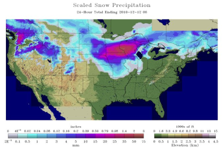
Here is the latest from NOAA's National Snow Analysis (click "Snow Precipitation")
Stuck In A Snowy Rut? When it rains it pours, right? The same thing often holds true during the winter months. It appears that the pattern is becoming stuck in a holding pattern, one that favors unusually cold, snowy weather for the Upper Midwest, Great Lakes and parts of New England. The next clipper (Wednesday) may dump out as much as a foot of snow on parts of far southwestern Minnesota, possibly 4-8" for Mankato and Marshall. The models print out 11" for Slayton by Thursday morning. We'll see, but there's little doubt that the farther south and west you travel Wednesday the greater the odds of a "plowable" snow.
Potentially "Plowable" (Again). It's only mid December and I'm starting to sound like a broken record (skipping CD/buggy MP3). The NAM/WRF model prints out .26" by the end of the day Thursday. With surface temperatures in the low to mid 20s that may translate into 3 or 4", maybe 6"+ far southwestern suburbs. It appears that MSP will be right on the edge of the significant snow from Wednesday night into Thursday evening.
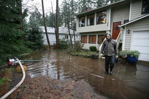
This Forecast Stinks. The Pacific Northwest has been pounded by a parade of soggy storms pinwheeling in off the Pacific, each one unloading 1-3" rains. The flood situation has gotten so bad, the ground so waterlogged, that raw sewage from septic systems and overwhelmed storm sewers has been released into the flood waters - more on the crappy turn of events for the Seattle area
here from the Seattle Times. By the way, these (supersized) Pacific storms usually weaken (dramatically) as they cross the Rockies, leaving us with minor clippers capable of a few inches of snow. Not so this winter season. These storms are much stronger than usual. Exhibit A: Saturday's record December snowfall for the Twin Cities.
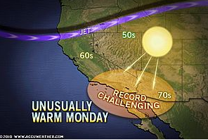
Record-Breaking Warmth Grips Los Angeles, Phoenix. Accu-Weather has a good
explanation of the strange contrasts across the USA right now: a record 83 in L.A. on Sunday, while most of America east of the Rockies shivers through a premature outbreak of January-like cold.
Snow Goggles. Looking for a unique holiday gift for the snow enthusiast in your life - someone who LIVES to be out in the elements in zero-visibility, white-out conditions? Here's an interesting
post from neatorama: "
With a major winter storm set to hit much of the U.S., this seems to be an appropriate time to share photos from The British Museum illustrating how mankind has coped with winter in earlier periods.
The top piece was created by Siberian craftsman, using leather, white metal, and beadwork. The bottom one comes from Salekhard, made of “metal, cloth, skin (reindeer, with fur), brass, beads, and buttons (brass).”
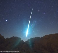
The "Geminids". From
NASA Science News: "
The Geminid meteor shower, which peaks this year on Dec. 13th and 14th, is the most intense meteor shower of the year. It lasts for days, is rich in fireballs, and can be seen from almost any point on Earth. It's also NASA astronomer Bill Cooke's favorite meteor shower—but not for any of the reasons listed above. "The Geminids are my favorite," he explains, "because they defy explanation." Most meteor showers come from comets, which spew ample meteoroids for a night of 'shooting stars.' The Geminids are different. The parent is not a comet but a weird rocky object named 3200 Phaethon that sheds very little dusty debris—not nearly enough to explain the Geminids. "Of all the debris streams Earth passes through every year, the Geminids' is by far the most massive," says Cooke. "When we add up the amount of dust in the Geminid stream, it outweighs other streams by factors of 5 to 500." This makes the Geminids the 900-lb gorilla of meteor showers."
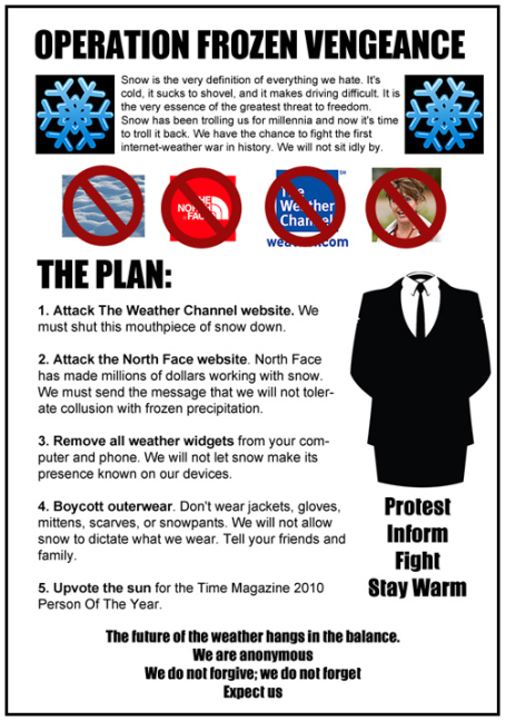
Anonymous Declares War On Snow. Now I've really seen everything. From geekosystem.com's
web site.
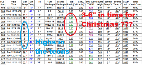
A Very "White" Christmas - And Hints Of A Late Month Thaw? It's still a long way off, but the GFS model is printing out close to .40" liquid on December 23-24. With highs in the teens to near 20 and a snow/rain ratio close to 15/1 that could easily translate into 3-6" right before Christmas, with an outside chance of 8" close to home. Keep that shovel handy. You're 'gonna need it this month. The same model is predicting a high close to 32 on December 29, the first shot at dripping icicles looking out 2-3 weeks.
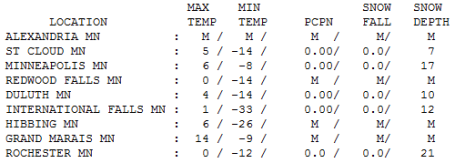
Could Have Been Worse. Monday was a few degrees warmer than I was expected - we made it all the way up to 6 (above!) in the Twin Cities after waking up to -8. Morning lows ranged from -33 at International Falls to -8 at MSP. As of this morning there is 21" on the ground at Rochester, 17" Twin Cities, 10" in Duluth (that's messed up), 12" International Falls and 7" up at St. Cloud.
 Paul's Conservation MN Outlook for the Twin Cities and all of Minnesota:
TODAY: Intervals of sun, not quite as bitter. Winds: SE 7-12. High: 8
TUESDAY NIGHT: Patchy clouds, staying above zero in the metro area. Low: 2
WEDNESDAY: Clouds increase. Light snow arrives later in the day. High: 17
WEDNESDAY NIGHT: Periods of snow, maybe an inch or two. Low: 8
THURSDAY: Snow tapers to flurries, slick spots? High: 21
FRIDAY: Patchy clouds, few flakes - better travel. High: 19
SATURDAY: Cold sun, flurries arrive late. High: 13
SUNDAY: Flurries taper, some PM sun. High: 15
MONDAY: More accumulating snow? High: 20
Minne-Snowda!
The warm, protective embrace of "El Nino" is nowhere in sight. Take a bow: you're living through the 5th snowiest December in modern-day records (since 1891). 24.2" - and the month isn't even half over!
17.1" fell at MSP International Airport, the 5th biggest storm on record, the most since the Halloween Superstorm of 1991, a new two-day snowfall record for MSP. 18-23" fell just south/east of MSP with towering 4-6 foot drifts. Seems all those perpetually-skeptical/cynical AM radio "personalities" are still shoveling 2 feet of "weather-hype" off their driveways.
What's unusual about the storm: it approached from the Pacific, a super-sized, energized clipper-like storm that mutated into something much more as it tracked across Iowa. Most of our mega-dumpings approach from Texas, not Wyoming or Colorado.
The pattern is temporarily "locked", a flow direct from the Yukon pouring bitter air into the eastern half of the USA; Pacific storms pumping moisture up and over this cold dome resulting in one snowy episode after another. Another inch or two is possible Thursday, more snow next Monday, another potentially "plowable" snow event by the 23rd. Yes, Virginia, there is a Santa Claus. This year he's bringing LOT'S of snow.
Heavy Storm Hits Mideast, Sinking A Ship. Here is an excerpt from an AP
story on the latest severe storm to sweep across Europe, this one powerful enough to stretch as far south as the Holy Land. "Heavy rains and fierce winds pummeled countries across the Middle East over the weekend, sinking a ship off
Israel’s coast and killing a woman in Lebanon whose car was crushed when a tree fell on it. The storm brought unusually cold temperatures, below freezing in some spots. In
Syria, snow blanketed the streets of Damascus for the first time this winter. In
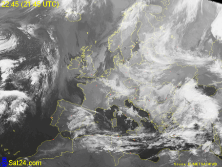
Egypt, 12-foot waves shut the port of Alexandria, the country’s largest, as well as another in the town of Nuweiba along the Red Sea coast of the Sinai Peninsula. Syrian authorities closed their main port of Tartous. Sandstorms blanketed Cairo for a second day on Sunday, choking the air with dust and turning the sky a tepid beige. Doormen and shopkeepers tried in vain to keep the swirling dust at bay, sweeping sidewalks and dusting off parked cars." To see the latest satellite imagery for Europe (best I've found on the web free of charge) click
here.
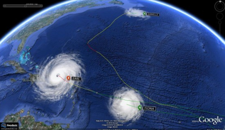
The 2010 Hurricane Season - Google Display. Anthony Watts has a great overview of the 2010 hurricane season (via the magic of Google Earth). An excerpt from his
blog: "
The surprising thing to me was the uniformity of the coverage. It looks like someone set out to sweep the entire area with the hurricane broom. It emphasizes the “heat-seeking” nature of hurricanes and thunderstorms. Both of them move preferentially to the warmest area in their path. There, they remove heat from the ocean and transport it to the upper troposphere. Subsequent hurricanes or thunderstorms tend to avoid the areas that have already been cooled."
 The Future Super Smartphone
. Can you imagine using your cell phone like a credit card? It's coming, along with the ability to watch (quality) local and national live TV streams on your iPhone 6. Count on it. An interesting look ahead from seekingalpha.com is
here.
A Day In The Life of Doppler On Wheels.The "DOW" is usually deployed to study tornadic, supercell thunderstorms, but during the winter months this portable Doppler is redeployed to study lake effect, capable of torrential snow, even "thunder-snow". An excerpt from an interesting
article in physorg.com: "
Rare anywhere, thundersnow is sometimes heard during the lake-effect snowstorms of the Great Lakes. The interaction of clouds and ice pellets inside these storms generates a charge, with lightning and thunder the result. How to catch thundersnow in action? This winter, a stalwart veteran of tornadoes, hurricanes and other severe storms will be waiting. It's called the Doppler-on-Wheels (DOW), a National Science Foundation (NSF) national facility used by NSF-supported and other researchers. In rain, sleet or snow, like the postman, it always delivers ... storm data.The DOW looks more like the dish of a radio telescope than a sophisticated weather instrument. It's mounted on the back of a flat-bed truck. DOW-on-board, the truck becomes an odd configuration of generator, equipment and operator cabin."
Will Steger Views Global Warming From The Coldest Places On Earth (Podcast). My good friend, Will Steger, a local Minnesota institution, has seen the impact of climate change with his own eyes, via repeated expeditions across the Arctic and Antarctic. His Powerpoint presentation showing "before" and "after" photos documenting the changes, especially near the North Pole, are very convincing. Some recent
comments on his findings: "It's almost as if Antarctica didn't want us there and was continually trying to kill us," says
Will Steger of his
seven-month dogsled expedition across the southern pole. But the journey wasn't just arduous and unprecedented, it was an eye opener for this hardened explorer. Steger and his team crossed the Larsen B ice shelf, a frozen and seemingly immovable mass that later crumbled into the sea, becoming a chilling symbol of a climate in collapse. Though he's broken countless records, Will Steger's current expedition is
educating the world (and especially kids) about the science and economics of climate change. But his days of traversing the tundra with his sled dogs are far from over."
Climate Talks End With Modest Deal On Emissions.
Here is a good overview of what just happened in Cancun: "The United Nations climate change conference began with modest aims and ended early Saturday with modest achievements. But while the measures adopted here may have scant near-term impact on the warming of the planet, the international process for dealing with the issue got a significant vote of confidence. The agreement fell well short of the broad changes scientists say are needed to avoid dangerous
climate change in coming decades. But it lays the groundwork for stronger measures in the future, if nations are able to overcome the emotional arguments that have crippled climate change negotiations in recent years."
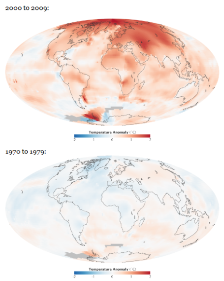
Keeping The "Big Picture". The cold air swirling outside our windows is "weather" - a snapshot of current conditions. It's human nature to assume that what's happening outside is somehow indicative of what the bigger trends are worldwide. Yes, it's cold. Yes, December will absolutely wind up colder than average across most of North America, making up for the warmest November on record (talk about compensating!) But the data coming out of NASA is pretty convincing: "The next time anyone tells you that the world is actually cooling, not warming, simply point them to
these global temperature maps from NASA’s Goddard Institute for Space Studies."
Data courtesy of the environmental site good.is.
New Blizzard Is Sure To Create More Climate Change Debate. Examiner reporter Ryan Witt
delves into the sticky, counterintuitive topic of "how can we be seeing more blizzards if the Earth is warming up?" I hear this all the time. Nobody seems to push back when I show them the evidence that weather patterns are becoming more severe. It turns out that IPCC climate scientists DID predict more outbreaks of severe weather, summer and winter. More snow and outbreaks of severe cold don't disprove long term (global) trends. Much of the year was abnormally warm: 19 nations set all time record highs in 2010, and in spite of December shivering over much of the Northern Hemisphere and Europe 2010 will probably tie 2005 for the warmest year on record, worldwide.
2010 On Track To Become The Warmest Year on Record No, it's not just me spouting off - it's those left-wing, Rush-hating liberals over at NASA who made this pronouncement. This - in spite of the December cold (which means the heat earlier this year must have really been unusual - as much as 10-20 degrees warmer across parts of Canada). The story is
here.


ReplyDeleteWe stumbled over here promodaihatsu from a different web page and thought I might check things out. I like what I see so now i'm following you. Look forward to finding out about your web page yet again. The Gaming Club bears a license from the government of Gibraltar, and claims to be one of a pick few casinos that have a license from the Gibraltar government. A devotee of the Interactive Gaming Council (IGC), The Gaming Club follows all the guidelines laid alongside by the organization, something that has taking into account a long habit in it bodily recognized as a great area to gamble online.
Everything not quite The Gaming Club feels good; be it the promotions, the big number of games, the compound banking options upon offer, the avant-garde security measures, or the fair and responsible gaming practices the casino adopts.
The Gaming Club motors along upon software developed by one of the giants of online gaming software innovation Microgaming. The software it uses is modern and has a range of features expected to include your online gambling experience and make you desire to arrive put up to after all circular of gambling you attain here.
Another hallmark of a good casino is the setting of its customer withhold team, and The Gaming Club does not disappoint upon this front.
http://magnum4dlive.com/tag/promodaihatsu/