Todd Nelson's Conservation MN Outlook for the Twin Cities and all of Minnesota:
**Latest Model Guidence Suggests Heaviest Snow Bands Stay South and West of Metro**
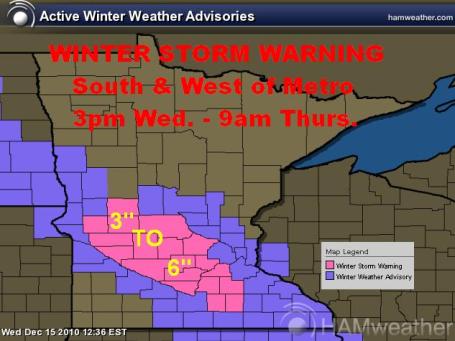
**WINTER STORM WARNING ISSUED south and west of Metro**
3pm Wednesday - 9am Thursday
Potential of 3" to 6" along Minnesota River Valley - Metro Gets Clipped
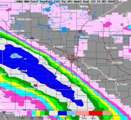
Here's the Latest NAM Model
This particular weather model keep the finicky storm south and west of the Metro, we may only see a few flakes, but 50 to 75 miles away, there could be a solid 3" to 6" total through Thursday
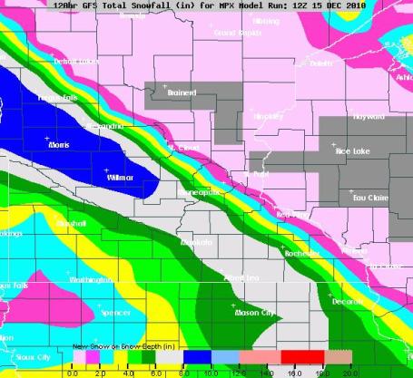
Here's the Latest GFS Model
The latest GFS model bring the heavier snow amounts closer to home, but only clips the south western edge of the metro with a few inches.
WEDNESDAY: Clouds Thicken. Light snow developing. Could see an inch or two south and west. High: 16
WEDNESDAY NIGHT: Mostly cloudy with periods of snow, maybe an additional inch or two. Low: 11
THURSDAY: Snow tapers late, potential for snow totals of 2-4" (totals from Wednesday thru AM Thursday) especially south and west. It may be enough to plow/shovel. High: 19
FRIDAY: Patchy clouds, few flakes - better travel. High: 15
SATURDAY: Partly sunny, flurries arrive late. High: 13
SUNDAY: Light snow potential south of town. Otherwise, partly sunny and still cold. High: 14
MONDAY: Mix of clouds and sun. High: 14
TUESDAY: Cold start, some sun. High: 16
**PREVIOUS DISCUSSION**
**PREVIOUS DISCUSSION**
Flip-Flopping Models/Snow Chances
One of the toughest types of storm to forecast snow totals for is "Clipper" systems - those finicky and fast moving systems that you can either use a shovel/plow to clean up with or just a brush/broom. Take a look at the impressive, but narrow band of snow that looks to develop Wednesday through Thursday across parts of Minnesota.
The NAM Model
The NAM model suggests that the heaviest amounts of snow (3" to 6") will be just south and west of us. We literally get grazed by the very narrow and robust snow band Wednesday through Thursday.

The GFS Model
The GFS model suggests the heaviest snow band (3" to 6" or more) setting up right on top of us, enough to shovel and plow.

Pick Your Poison
If we go with the NAM model, we may only see a dusting... If we go with the GFS model, we could see as much as 6"... UGH! Forecasting snow totals from a dusting to 6" is pretty ridiculous, in my opinion, but with such a finicky storm track and such a narrow band expected, it's tough to say EXACTLY where the heaviest snow will be.
The 10% Line
NOAA's Hydrological Prediction Center (HPC) puts together a snow accumulation probability map and in this particular case, the 10% chance of at least 4" of snow from 6pm Wednesday to 6pm Thursday is drawn very near our location. Are you thinking what I'm thinking?? 10%... whoopie ding! That's not a very good percentage at all.

What Can You Expect?
Regardless of the 10% chances line, the forecast for accumulating is fairly certain at this point for parts of Minnesota. Be advised that snow may hamper commutes PM Wednesday and or AM Thursday as this next system skips through your or your neighbors backyard.
Looking Over the River and Through the Woods - A Developing Xmas Storm?
The highly laughable and uncertain extended 10-day forecast model is picking up on something that may be brewing around Xmas even around the central Rockies. Will this verify? It'll be interesting to see what the next model runs says... As I mentioned, these extended model runs can be highly laughable. Every once in a while, the mathematics, the calculations can anticipate a few of the boulders and bends in the chaotic river or fluid atmosphere we call weather!

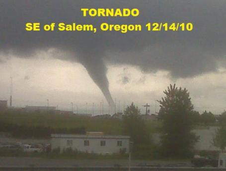
Tornado Strikes Near Salem, Oregon on Tuesday!
Are you kidding me? Tornadoes in Oregon... in December... WHAT? A strong Pacific storm along with temperatures well above avearge, created enough instability to whip up tornado in a very unsual place... OREGON!! Read the full story, see more pictures and watch the video HERE:
Have a good Wednesday!
Meteorologist Todd Nelson
No comments:
Post a Comment