* The good news: the coming wave doesn't look quite as Nanook (maybe 1-3 days below zero between next Tuesday and January 24). Hey, we can handle that. It's the 2 weeks/row of subzero cold that can be tough for even the heartiest of souls to endure.
* The bad news: the thaw envisioned for the last week of January has been pushed back (and weakened) by the latest GFS model run. I still expect a warming trend the last few days of January - but no rain (better news for snow lovers) and probably no extended period of 30s, at least not in January.
* Sort of a mixed bag of news. The good news: no major, Snowmageddon-like snowfalls anytime soon. The bad news: it only takes an inch of powder (at 5 degrees) to turn roads into ice skating rinks.
A couple inches may fall late Thursday, especially north/east of the Twin Cities, another 2-3" possible late Friday and Friday night. If it snows an inch or two on Monday - as temperatures fall through single digits to below zero values over central, northern and western MN, that could be more problematic. Snow + 5 degrees + continuous traffic on the highways = glaze ice, the black ice we all dread. Not sure it will happen yet, but there's a chance next Monday as the core of the coldest air arrives. By Tuesday, under a blue sky, temperatures may not climb above zero, even in the metro area.
* The best chance of more subzero weather: next Tuesday, the 18th, Thursday the 20th, and Sunday the 23rd of January. We'll see, but each model run eases up (a little) on the severity of the cold, while pushing any warming trend later and later into the end of January. A mixed weather bag indeed.
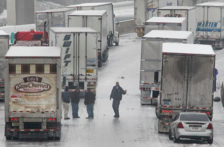
Parking Lot Conditions. 4-6" snow, coupled with 1" of glaze ice = meteorological basket case. From the Atlanta Journal Constitution: "
Truckers are at a standstill near Clark Howell Highway on Tuesday. The eastern stretch of I-285 south of the airport between most of I-85 and I-75 and has been a sheet of ice since Monday." The AJC has a good, chronological run-down of the storm's effect on the Atlanta area
here.
 Crippling Snowstorm
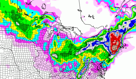
. While we expect a series of plowable snowfalls late Thursday, Friday night, again Monday, much of New England will see a concentrated burst of heavy snow (and wind) over the next 12 hours. The latest NAM model (valid through 1 am Saturday morning) prints out close to 20" from Long Island to Hartford to the suburbs of Boston. This storm will temporarily shut down the northeastern USA, New York City will wind up with 8-12", only an inch or so for Washington D.C. The same model prints out a total of 3-5" for much of the Twin Cities metro area between now and Saturday morning, coming in two bursts.
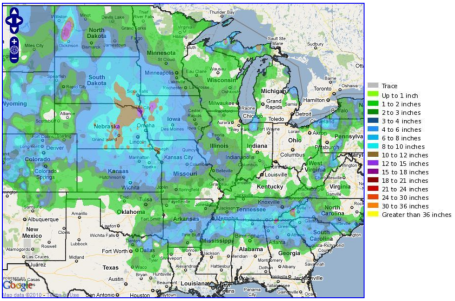
Snow Amounts Since Sunday. A slow-moving, long-lasting light snow event has been lingering across the Midwest and Central Plains since Sunday, producing some impressive snowfall amounts, especially southeastern South Dakota, eastern Nebraska and western Iowa. From the local NWS office: "
A combination of two systems impacted a large part of the nation with winter weather from January 9th through the 11th. The first system moved southeast from the central Plains through the lower Mississippi Valley and then into the Carolinas, producing heavy snow and sleet from Arkansas to North Carolina on the 9th. The second system moved from Montana, southeast to the mid-Mississippi Valley on the 10th and 11th. This was the system that produced the prolonged, mainly light snow across southern and central Minnesota, and eventually into western Wisconsin by the night of the 10th." More details
here.
Snowfall Updates From NCEP
...IOWA...
RINGSTED                             12.0
FORT DODGE 5 NNW                      9.8
DES MOINES 5 WNW                      9.1
MURRAY                                8.1
CLIVE 1 E                             7.7
NEWTON AIRPORT 3 WNW                  6.4
HEATH MEMORIAL CO 3 NNE               6.0
KEOSAUQUA 1 N                         5.0
WHAT CHEER 4 E                        4.5
DUBUQUE REGIONAL ARPT                 2.7

...ILLINOIS...
WAUKEGAN                              6.7
HIGHWOOD 1 NE                         6.0
MORRISONVILLE                         6.0
PANA                                  5.5
OHARE AIRPORT                         5.2
PEORIA                                5.0
NOKOMIS 5 NW                          4.8
PLAINVILLE                            4.5
SPRINGFIELD                           3.1
MOLINE QUAD-CITY ARPT                 2.9
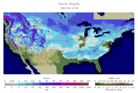
Snow On Every State (Except Florida). From an e-mail I received Tuesday from Mark Hoekzema from WeatherBug:
"Currently 49 out of 50 states—Florida is the exception—have snow on the ground. This includes Hawaii, where there are about seven inches of snow atop Mauna Kea. This unusual occurrence was made possible by this week’s snowstorm across the South. As of today, 69.4% of the contiguous U.S. is covered by snow—more than double the snow cover from last month."
See for yourself by clicking "Snow Depth" here.
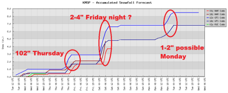
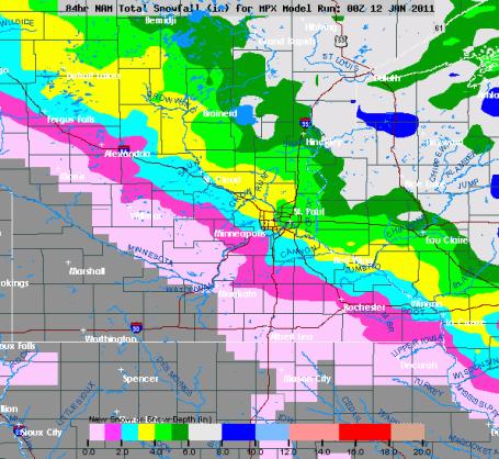
Family Of Clippers. 1.5" to 2.5" snow fell from Monday into Tuesday morning. Models are suggesting another inch or 2 late Thursday, another 2-3"+ inches possible Friday night, maybe another plowable snow event of a couple inches next Monday. Yes, at the rate we're going we're well on our way to 65" of snow this winter, maybe 70" in a few towns by March. Looks like we got our Winter Weather Mojo back this year - either go BIG or go home, right?
Expected Snow. Models are hinting that clippers late Thursday and Friday will drop the most snow north/east of I-94, maybe 3-5" of new snow from Fergus Falls and Brainerd to St. Cloud and the far northern/eastern suburbs of MSP by Friday.
I suspect we'll see 2-4" of new snow by Saturday morning, maybe a couple more inches Monday as the core of the Arctic air arrives. Plenty to look forward to.
The Perils of Long Range Prognostication. What happened to yesterday's thaw scheduled for the end of the month? That's why the GFS (and anything beyond 5-7 days) should be thought of as a trend, not a "forecast." Too much that can change that far off, especially with jet stream prevailing winds howling at 150 mph a few miles overhead. Now the model is hinting at two bitter outbreaks, around Jan. 21, another one January 24. The good news - they appear relatively brief - no sustained subzero weather (that I can see). Any thaw has been delayed until the last few days of January. Sorry to get your hopes up. I want to believe that a warmer front is right around the corner. This year we'll have to wait a little longer for temperatures to recover.
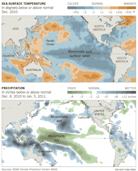
La Nina's Pattern Not Holding True For Southern California. This winter has been a real head-scratcher for meteorologists, not fitting the traditional mold of a La Nina winter. Since last summer we knew the Pacific was going into a cooling phase, one that often correlates with colder (drier) winters for Minnesota. La Nina winters tend to be drier for the west coast - but not this time around. Australia has been inundated (which fits the pattern of La Nina), but since December the steady parade of storms slamming into the west coast has been more typical of an El Nino winter, than a La Nina event. Very odd. Quoting a
story in the New York Times: "
For meteorologists and climate scientists, the flooding that has affected the Australian state of Queensland has not been unexpected. It is seen as collateral damage from the current La Niña, a lowering of sea-surface temperatures in the tropical eastern Pacific Ocean. While a typical La Niña — the low-temperature side of the cycle known as the El Niño/Southern Oscillation — usually brings wet weather to the western Pacific, it also brings dry conditions to the Southern United States, including Southern California. But since late December, Southern California has been hit by severe rainstorms, with some areas receiving nearly a normal year’s worth of precipitation in a few weeks."
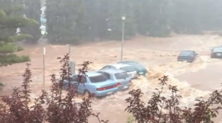
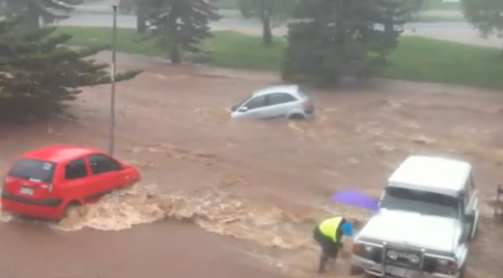
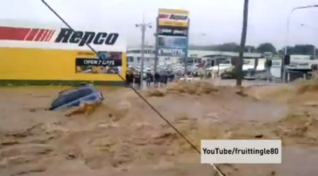
Australia: Worst Flooding in 40 Years. The flooding in Queensland has been devastating in recent works - and it seems to be getting even worse, surges of water surging downstream being described as "mini-tsunamis". From
Citizentube.com: "
Flash flooding in Queensland, Australia continues to uproot countless suburban towns. The floods, which are described as behaving like a mini-Tsunami, have already claimed 10 lives and led to tens of thousands of evacuations."
Definition Of A Flash Flood.
This is some of the most incredible flood footage I've ever seen - more examples of the historic flooding affecting millions of "Aussies" down under - hardest hit: northeastern Australia, around Queensland. Rivers are expected to crest in Brisbane, on the coast, in the coming days.
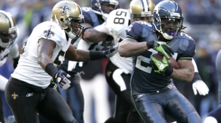
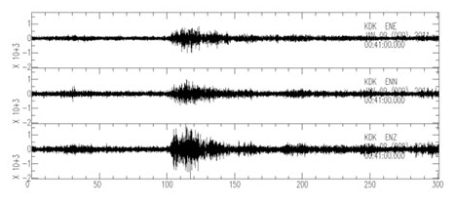
Marshawn Lynch Touchdown Shakes Ground In Seattle, Measures On Earthquake Scale, Scientists Say. A
report in the New York Daily News shows how fans, jumping up and down in unison during Lynch's surreal return - shook the ground hard enough to show up as a seismic tremor - a minor earthquake! "
Marshawn Lynch's 67-yard touchdown on Saturday shook up more than the defending Super Bowl champions. The audience's reaction was enough to measure shaking equivalent to a small earthquake, according to the Pacific Northwest Seismic Network. Joe Vidale, the director of PNSN, said the seismic tools showed the fan applause beginning at the start of Lynch's pivotal touchdown run and peaked when the Seahawks kicked off to the Saints."
"Beast Quake!" Here is the seismograph from Sunday's championship football game in Seattle, timed for Lynch's (amazing) touchdown run. Marshawn told reporters after the historic run that he went into "beast mode", touching off the touchdown tremor. More from KING-TV in Seattle
here.
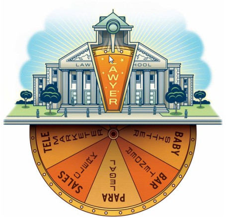
Is Law School A Losing Game? No, this has absolutely nothing to do with weather, but I'm trying to include a few stories that catch my eye during the day. Click
here to read a mind-boggling story (a little long, but well researched and very well written) from the New York Times. The gist of it: law schools fudge the numbers and inflate their credentials (and successes with graduates finding "jobs" after graduation) to score consistently well on the U.S. News and World Report ranking of best law schools in the USA, that comes out every year. The reality: many lawyers are graduating with 200-250K or more in education bills, with little chance of landing a legal job that will enable them to pay off their ballooning debt. There are far too many law students, not nearly enough good paying jobs in the legal system. Many argue that the game is now rigged: "
A law grad, for instance, counts as “employed after nine months” even if he or she has a job that doesn’t require a law degree. Waiting tables at Applebee’s? You’re employed. Stocking aisles at Home Depot? You’re working, too. Number-fudging games are endemic, professors and deans say, because the fortunes of law schools rise and fall on rankings, with reputations and huge sums of money hanging in the balance. You may think of law schools as training grounds for new lawyers, but that is just part of it. They are also cash cows."
 Candy-Coating Of Snow
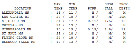
. The Twin Cities metro picked up 1.9" Tuesday, on top of the 1.5" that fell on Monday. Higher math: 3.4" since late Sunday night, bringing the snow total on the ground to 12". St. Cloud saw 1.5" Tuesday, highs in the 20s across most of the state, fairly close to average for the 11th day of January.
Paul's Conservation MN Outlook for the Twin Cities and all of Minnesota:
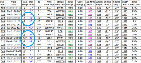
TODAY: Intervals of sun. Best travel day of the week. Winds: NW 8-13. High: 19
WEDNESDAY NIGHT: Partly to mostly cloudy. Low: 3
THURSDAY: Light PM snow, 1-2" possible late. High: 17
FRIDAY: Another burst of snow late, another 1-3" possible Friday night. High: near 20
SATURDAY: Intervals of sun, good day to go skiing or ice-fishing. High: 19 (above zero!)
SUNDAY: Mix of clouds and sun, brisk. High: 15
MONDAY: Chance of light snow, 1-2" powder possible with very slippery roads. Turning bitter. Low: -2. High: 4
TUESDAY: Numbing sunshine, one of the colder days of winter. Low: -9. High: 0
The Cruelest Month
It's that time of year, when going out to get the morning paper is an adventure. Taking the trash out is a slippery expedition. Look at it this way: the next 2 weeks will be an insurance policy,preventing us from ever becoming "Chicago with lakes". Subzero "highs"? Mounds of snow so high you can't safely pull out into traffic? Yes, we got our Winter Mojo back this year; the next 14 days will keep future population growth in check.
By the way, pets (including horses) DO feel the wind chill. Lately my 15 year old spaniel, Max, has been doing his business in the basement, rather than risk doggy frostbite outside. Can't say I blame him.
While New York digs out from a foot of snow (closer to 2 feet for Boston) our storms will be pretty minor league into the weekend. The next clipper arrives late Thursday, a quick 1" or more, maybe another fresh, grime-covering coating of powder late Friday, again Monday, no more than 1-2" each time. Maybe enough snow to cover up Max's thoughtful presents lurking in our front yard.
The next 2 weeks may be the coldest of the winter season with 1-3 days below zero. Any thaw has been delayed until late January. We'll earn our spring in 2011.
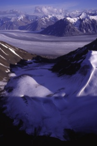
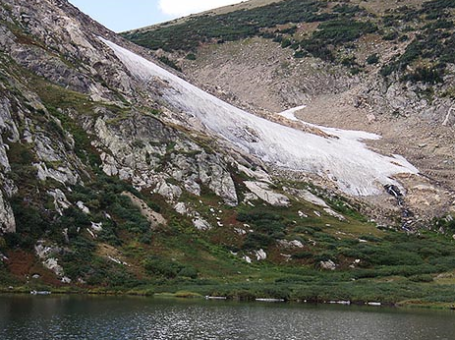 Half Of World's Small Glaciers To Be Gone By 2100, But There's Good News For The Himalayas
. From a recent
article at treehugger.com: "
A new study in Nature Geoscience examining glaciers melting due to climate change forecasts tough times for the world's small glaciers, but offers a more hopeful outlook for Himalayan glaciers.The research, the most comprehensive of its kind carried out so far, shows that about half of glaciers under 5 square kilometers in area will disappear entirely by 2100, in the process contributing during that time period the same amount of water to global sea level rise as the melting of ice sheets in Antarctica and Greenland, about 12 centimeters. Glaciers of this size comprise about 40% of the world's total glaciers. "
Climate: Unstoppable Global Warming. When I tell people that climate change is a "slow motion crisis" they look at me funny, wonder if I'm just trying to make a point or get more attention. It's such a big and daunting subject that many would prefer to look away, change the subject, kick the can down the road. But that decision has implications too. From a Time magazine
blog: "
One of the biggest obstacles to reducing carbon emissions is the simple fact that political time and climatological time are very, very different. Politicians in elected democracies think on two- or four-year cycles—if that—while even the leaders of an autocratic state like China, without the pressures of an election, are still limited in just how far ahead they can plan. That's not just politics—that's human psychology. We tend not to be very good at planning for the future—just look at the long-term decline in the American savings rate—and that's just thinking over the scale of a human lifetime. Climatological time is closer to "deep time," the writer John McPhee's term for how the planet's geology changes over millions to even billions of years, a span of time simply unfathomable to human beings. Climate can change a lot faster than that—thanks largely to the billions of tons of greenhouse gases we've been pumping into the atmosphere over the past 150 years—but it still moves a lot slower than political time, so it's easy to put off until tomorrow."
Climate Change May Continue For At Least A Millenium. A
story from Bloomberg News: "
Climate change may be unstoppable for the next millennium. Rising carbon-dioxide levels in the atmosphere will affect the climate for at least another 1,000 years, based on a simulation by researchers at Canada’s University of Victoria and University of Calgary. That will cause the West Antarctic ice sheet to collapse by the year 3000 and raise sea levels by 4 meters (13 feet), it showed. The study, published online in Nature Geoscience, is the first full climate model to make predictions so far into the future, the Calgary university said in a Jan. 9 statement. Researchers studied the length of time needed to reverse climate-change trends if the world stopped using fossil fuels and putting CO2 in the atmosphere as of 2010 and 2100."
A Marshall Plan For Endangered Species. From an
article at Huffington Post: "
If your house were on fire, what would you save? Where would you even start? What if not just your house, but your whole planet was on fire? That is the scenario we face today. Climate change has arrived. No longer clouds gathering in the distance, the firestorm is here now--melting titanic glaciers, drying mighty rivers and setting deserts ablaze. With our new report, It's Getting Hot Out There: The Top 10 Places to Save for Endangered Species in a Warming World, the Endangered Species Coalition and our member groups attempt to answer the question: To save endangered species from climate change, where do we begin?"
Is Malaria Coming Home To Roost? From a recent article at the Washington Post: "
The idea that climate change will bring malaria and other tropical killers to our door turns out to be an extremely controversial one among ecologists, climatologists and biologists such as Marcelo Jacobs-Lorena, who runs the "insectary" at Johns Hopkins. "It's a very complicated story," says Jacobs-Lorena. The malaria map accompanied a 2000 article, written by Harvard biologist Paul R. Epstein, that raised the alarm about the impact of global warming on the spread of infectious diseases. It helped influence a research agenda that last year resulted in more than 4,000 studies of climate change and disease. Epstein believes that evidence of the disease risks of climate change have only grown in the past decade."

No comments:
Post a Comment