* No big storms in sight through next week.
* Models hinting at a brief period of subzero weather by the middle of next week, maybe 2-3 subzero nights and one subzero day - not nearly as bad as we though a week ago. Each computer run weakens the Arctic cold wave, it now looks like it may just be a glancing blow of Siberian air.
* Long-range models hinting at a thaw (again) the last week of January. Confidence level is low, but this is the second time in 3 days that the long-range (GFS) model has pulled milder, Pacific air into Minnesota after January 22 or so.
* 2010 tied with 2005 as the warmest year of the global surface temperature record, according to data released today by the National Climatic Data Center. Records began in 1880. The global land surface temperatures for 2010 were the warmest on record at 1.8 F above the 20th-century average. Nine of the Earth's 10 warmest years on record have occurred since 2001, and all 12 of the warmest years have occurred since 1997. (source: NOAA, USA Today).

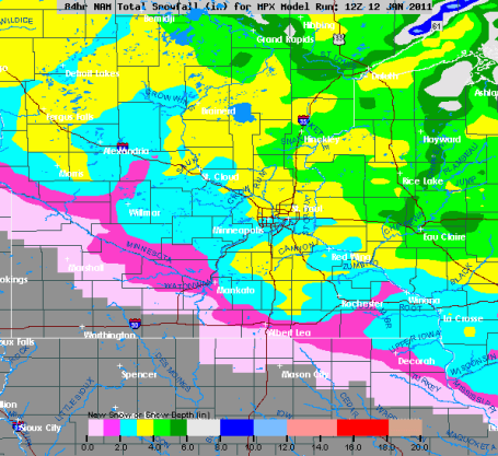
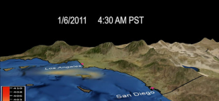
Couple of Clippers. This model may be overdoing the snow. At least two relatively quick bursts of snow are on the way, one shot of light snow later today (coating?), another chance late Friday and Friday night - models hinting at an inch, maybe 2" for much of the metro by Saturday morning.
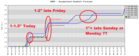
Timing The Clippers. Models are all consistent in bringing in a coating-1" of snow later today and this evening, maybe 1+" late Friday and Friday night, another burst of snow (maybe 1") late Sunday or Monday as much colder air approaches, each snow event marginally "plowable". Based on the latest NAM I think amounts will be less than what this graph is showing, just enough to ice up a few roads tonight, again Friday night.
Huge Temperature Swing? Our on-again, of-again thaw may be on again. I know - it's frustrating, but that's what happens when you look out beyond a week or so. When the jet stream, the high-speed river of air circulating around the Northern Hemisphere, reaches 100-150 mph, it becomes highly unstable, capable of buckling. Sometimes the long-range models pick up on these changes, other times the models are unreliable until closer to the event. Latest (GFS) model data is hinting at subzero weather the middle of next week, right around the 19th, followed by a significant thaw after the 22nd. Not sure I believe it yet - want to see a few more runs before I get too excited. But this is the second time in 72 hours the long-range model has hinted at a significant late-month thaw. We'll see.

Snowiest Cities In America? From a very informative article at Yahoo.com: "Pity poor Clevelanders, especially during the winter. No hockey, no more LeBron James and, to top it all off, more snow than almost every major metro area in the U.S. The winds of Lake Erie pushing storms over the city drop an average of 59.3 inches of snow onto Cleveland each winter, according to historical data from the National Oceanic and Atmospheric Administration (NOAA). It's enough to make Cleveland the second snowiest major city in the U.S., just a couple of flakes behind Denver, which just tops 60 inches annually. But at least Denver boasts a claim as a gateway to a winter wonderland, with picturesque mountains and first-class skiing just a few miles away."
Here's The Top 5 (Major) Cities On The List:
Denver, Colo.
Average annual inches: 60.3
Cleveland, Ohio
Average annual inches: 59.3
Salt Lake City, Utah
Average annual inches: 58.5
Minneapolis-St. Paul, Minn.
Average annual inches: 49.9
Milwaukee, Wisc.
Average annual inches: 47.3
Snowfall Reports From NOAA:
CONNECTICUT
...FAIRFIELD COUNTY...
NEWTOWN 27.0 840 AM 1/12 SKYWARN SPOTTER
RIDGEFIELD 22.0 645 AM 1/12 PUBLIC
BROOKFIELD 21.5 730 AM 1/12 COCORAHS
WILTON 18.7 830 AM 1/12 PUBLIC
DANBURY 17.9 555 AM 1/12 SKYWARN SPOTTER
WESTPORT 17.4 815 AM 1/12 SKYWARN SPOTTER
NEW CANAAN 17.0 630 AM 1/12 SKYWARN SPOTTER
NORWALK 16.0 725 AM 1/12 PUBLIC
BRIDGEPORT 15.5 850 AM 1/12 NWS COOP
GREENWICH 14.5 800 AM 1/12 SKYWARN SPOTTER
STAMFORD 14.0 800 AM 1/12 SKYWARN SPOTTER
STRATFORD 13.0 700 AM 1/12 PUBLIC
DARIEN 12.6 745 AM 1/12 SKYWARN SPOTTER
RECORD EVENT REPORT
NATIONAL WEATHER SERVICE TAUNTON MA
300 PM EST WED JAN 12 2011
...GREATEST SNOWSTORM AND DAILY SNOWFALL TOTAL ON RECORD IN THE
GREATER HARTFORD AREA JANUARY 12 2010...
NEW SNOWFALL THROUGH 1 PM AT BRADLEY INTERNATIONAL AIRPORT IN
WINDSOR LOCKS CT TOTALED 22.5 INCHES. THIS BEATS THE GREATEST SNOW
STORM TOTAL 21.9 INCHES WHICH OCCURRED FEBRUARY 12 2006. THIS ALSO
BEATS THE GREATEST DAILY SNOW TOTAL 21.9 INCHES FEBRUARY 12 2006.


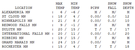
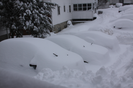
Perfectly Average. The sun was out, the temperature peaked at 21 in the Twin Cities, which is the average high for January 12. 10" on the ground at MSP (48" so far this winter). Rochester reporting 18" on the ground, 12" on the ground at St. Cloud.
Paul's Conservation Minnesota Outlook for the Twin Cities and all of Minnesota:
TODAY: Light PM snow, coating - 1/2" More possible north metro (1-2" late). Winds: S 10-15. High: near 20
THURSDAY NIGHT: Light snow tapers to flurries late. Low: 3
FRIDAY: Snow at night, another 1+" possible. High: 18
SATURDAY: Clouds increase, PM flurries. High: 15
SUNDAY: Sunny start, clouds increase with nighttime flakes. Low: -5. High: 7
MONDAY: Another clipper. Quick burst of powder, 1-2" ? High: 24
TUESDAY: Intervals of sun, chilly. High: 10
WEDNESDAY: Numbing start, clouds increase. Low: -8. High: 5

Snowbird Fever
Enjoying January? A neighbor e-mailed me yesterday. "Paul, do you ever get TIRED of winter? I know you have lived in the north most of your life, so have I. I'm just running out of gas to deal with it. I'm not planning on ending up in Minnesota, although for 6 months of the year it's the best place on the planet!"
What is it about our winters that is cumulative, each one gets a little harder to handle? A snowmobile, skis and an upbeat attitude all help, but between long nights (and not being able to find the mercury in your backyard thermometer) January is challenging; the Ultimate Test.
Good news: we've picked up nearly 20 minutes of daylight since Dec. 21 (today will offer 1 minute, 49 seconds of additional daylight than yesterday). Yes, it'll get colder, but the maps don't look as forbidding as they did a few days ago. A few subzero days are possible the weekend of January 22-23, but no prolonged, Nanook ordeals. Snow will come in dribs and drabs, 1" later today, maybe a couple inches Friday night, again Monday. I see a light at the end of the tunnel. Check my blog for news of 2010 tying the global temperature record.
Do I get tired? Yes, but summer is worth the pain.

• attend a sleepover
• have a playdate
• be in a school play
• complain about not being in a school play
• watch TV or play computer games
• choose their own extracurricular activities
• get any grade less than an A
• not be the No. 1 student in every subject except gym and drama
• play any instrument other than the piano or violin
• not play the piano or violin.
Weather Monitoring Company Turns To Greenhouse Gases. One of our favorite clients (and partners), WeatherBug, has rebranded itself as Earth Networks, expanding their mission to track greenhouse gases as well as other forms of weather data. A smart move. From an article in the New York Times: "The company behind one of the largest networks of weather monitoring stations on the planet — and the purveyor of the ubiquitous WeatherBug application and Web site — is betting that providing greenhouse gas data will also prove to be a lucrative market. AWS Convergence Technologies of Maryland plans to announce on Wednesday that it is rebranding itself Earth Networks, and that it will be making a capital investment of $25 million over the next five years to deploy a network of 100 greenhouse gas sensors at various sites around the planet — 100 in the United States, 25 in Europe and 25 more at locales yet to be determined."
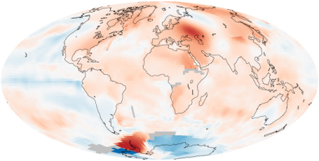
NOAA: 2010 Tied For Earth's Warmest Year On Record. The latest from an article at USA Today: "2010 tied with 2005 as the warmest year of the global surface temperature record, according to data released today by the National Climatic Data Center. Records began in 1880. The Earth's temperature was 1.12 degrees F above the 20th-century average, which was the same as 2005. It was the 34th-consecutive year that the global temperature were above average, according to the data center. The last below-average year was 1976. The global land surface temperatures for 2010 were the warmest on record at 1.8 F above the 20th-century average. Warmer-than-average temperatures occurred for most of the world's surface. The warmest temperatures occurred throughout the high-latitude regions of the Northern Hemisphere, Canada, Alaska, the tropical Atlantic Ocean, the Middle East, Eastern Europe and northern Africa. Nine of the Earth's 10 warmest years on record have occurred since 2001, and all 12 of the warmest years have occurred since 1997."
No comments:
Post a Comment