Weather For Really Busy People. It will snow (a little) today, coating to an inch, maybe 2"+ east of St. Paul, enough to plow near Rochester. Then it gets cold for much of the week, a few more inches Saturday, then (somewhat) milder next week, when a wave of 20s (above zero!) will come as a relief. We may even sample 32 F. by the middle of next week. Here in Minnesota, in January, we call that a "warm front".
If you have a little more time, read on....
Paul's Conservation Minnesota Outlook for the Twin Cities and all of Minnesota:
MONDAY: A period of light snow, 1/2 to 2". Slick. Winds: E 7-12. High: 26
MONDAY NIGHT: Light snow tapers to flurries with little additional accumulation. Low: 6
TUESDAY: Peeks of sun, turning colder. High: 8
WEDNESDAY: Plenty cold! Snow brushes far southern counties. Low: -9. High: 3
THURSDAY: Clearing, numbing breeze. Low: -6. High: 5
FRIDAY: Blue sky, Arctic breeze. WC: -20. Low: -11. High: 6
SATURDAY: Next clipper arrives, couple of inches? Low: 1. High: 19
SUNDAY: Intervals of sun, better travel day statewide. Low: -1. High: 13
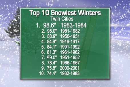
Top 10 Snowiest Winters For The Twin Cities. Keep in mind the rolling 30 year average for snowfall here in the cities is 50". We already have 52.4", by the end of this week we should be close to 55". As I mentioned in this blog a few days ago, if we just see "average" snowfall through April we should, on paper, pick up another 27-28".
My gut (based on how the pattern is progressing this winter: we'll wind up with close to 75" for the winter, which would put us in the Top 10. From a snowfall perspective the winter season is roughly half over. Good news for snow-lovers, but commuters won't be very happy to hear that statistic. Hey, I'm just the messenger. As much as I like snow (in my yard and on my favorite snowmobile trails up north) I too am REALLY looking forward to spring this year. Thanks to St. Cloud State University meteorologist D.J. Keyser for whipping up this graphic.
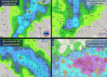
Snow Events So Far This Winter In The Twin Cities. The local Chanhassen office of the National Weather Service has a good summary of the snow events so far this winter season in the metro area, both minor and major
here.
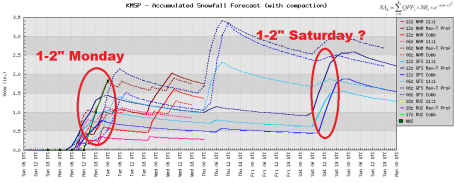
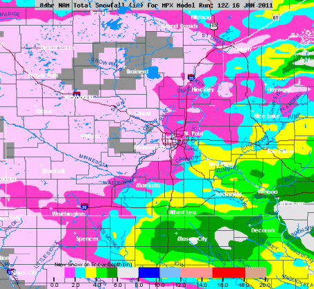
Couple Of (Minor) Snow Events. No cause for panic. That old adage, "when in a drought - don't predict rain" comes to mind. We're obviously stuck in a snowy pattern, and that trend will continue this week with a couple of (weak, fast-moving) clippers. They'll move too fast to tap any moisture from the Gulf of Mexico, but an inch or 2 is possible later today, again Saturday. No mega-whoppers in sight.
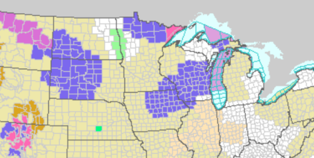
Winter Weather Advisories. The best chance of more than 2-3" later today will come over far southeastern MN, closer to Red Wing, Winona and Rochester. Click
here for the latest watches, warnings and advisories from NOAA.
East Side Snowfall? Latest models show the clipper intensifying as it tracks across the state, a much better chance of 2"+ east of St. Paul, maybe some 3-6" amounts over far southeastern Minnesota.
Tantalizing Hints Of A (Brief) Thaw. Yes, a cold week is on tap, probably 3 subzero nights, maybe 4 days with single-digit highs in the metro area. But the models still warm us up a little next week, a chance of a couple of days near 32 F. by the middle of next week. Only in Minnesota do the locals celebrate freezing!
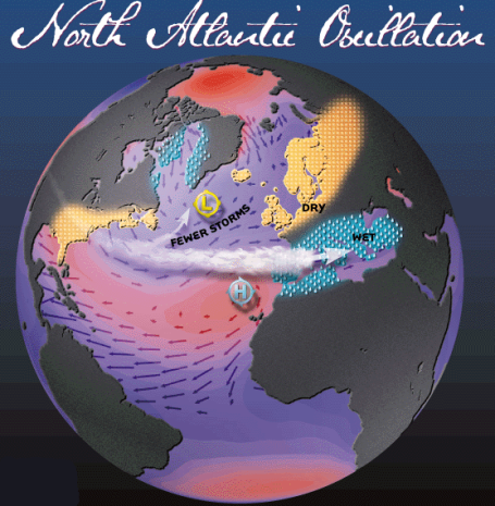
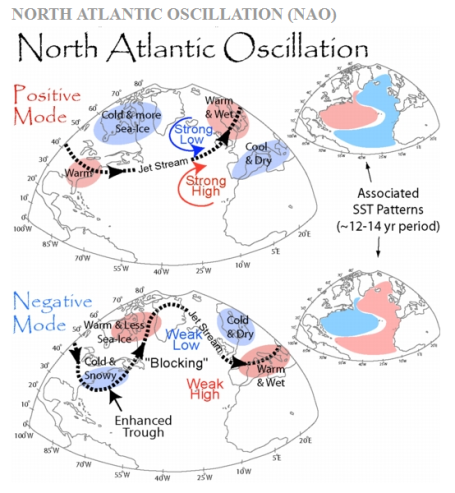
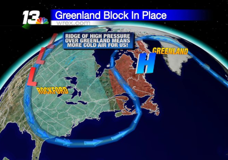
North American Oscillation - Negative Phase. Weather is complicated. And that's the understatement of the winter. Weather is, by its very nature, changeable and fickle. We're discovering that the oceans can nudge weather patterns in a certain direction (La Nina and El Nino). But superimposed on these natural cycles are blocking patterns, holding patterns that evolve from season to season. One big factor that helps to control our weather is the NAO, the North American Oscillation. Here's a good explanation from Kaitlin Alexander at
nextgenjournal.com: "
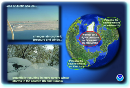
Usually in the winter, the air masses above the Arctic have low pressure, and the entire area is surrounded by a circular vortex of wind currents, keeping the frigid polar air contained. Everything is what you’d expect: a cold Arctic and mild continents. These conditions are known as the positive phase of the North Atlantic Oscillation (NAO), an index of fluctuating wind and temperature patterns that impacts weather on both sides of the Atlantic. The negative phase is different, and quite rare: high pressure over the Arctic forces the cold air to spill out over North America and Eurasia, allowing warm air to rush into the polar region. Meteorologist Jeff Masters has a great analogy for a negative NAO: it’s “kind of like leaving the refrigerator door ajar–the refrigerator warms up, but all of the cold air spills out into the house.” The Arctic becomes unusually warm, and the temperate regions of the surrounding continents become unusually cold. Nobody visually depicts this pattern better than freelance journalist Peter Sinclair. So what’s been causing this rare shift to the negative NAO the past two winters? In fact, global warming itself could easily be the culprit. Strong warming over the Arctic is melting the sea ice, not just in the summer, but year-round. Open water in the Arctic Ocean during the winter allows heat to flow from the ocean to the atmosphere, creating the high pressure needed for a negative NAO to materialize. Paradoxically, the cold, snowy weather many of us are experiencing could be the result of a warming planet."
A Complex Interaction Of Water, Ice and Air. Graphic courtesy of NOAA. More background information on the North American Oscillation (NAO)
here. NOAA has a good explanation of La Nina, and how this negative phase of the NAO may be impacting our weather
here.
NAO - Negative Phase. A warming Arctic region has shifted the coldest air thousands of miles south, swirling across North America, Europe and Asia. The greater the north-south temperature extremes, the larger the potential for significant storms. Factor in a 4% increase in atmospheric water vapor in recent decades (the result of warmer air evaporating more ocean water) and you "load the dice" in favor of more huge snowstorms, similar to the ones that struck Minnesota last month, and the subsequent parade of coastal storms for the east coast. Jeff Masters has a good explanation of the NAO (coupled with La Nina) and how these larger-scale patterns may beconspiring to breed colder, snowier conditions for much of the USA at his "Wunderblog"
here.
* The negative NAO index phase shows a weak subtropical high and weak Icelandic low.
* The reduced pressure gradient results in fewer and weaker winter storms crossing on a more west-east pathway.
* They bring moist air into the Mediterranean and cold air to northern Europe.
* The U.S. east coast experiences more cold air outbreaks, resulting in snowier weather conditions.
* Greenland experiences milder winter temperatures.
Another Look. From what I understand, negative phases of the North American Oscillation are relatively rare, and yet that has been the pervasive pattern the last 2 winters.
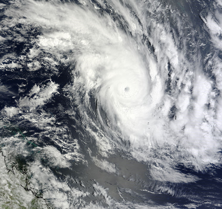
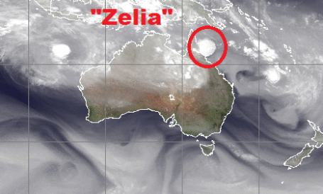
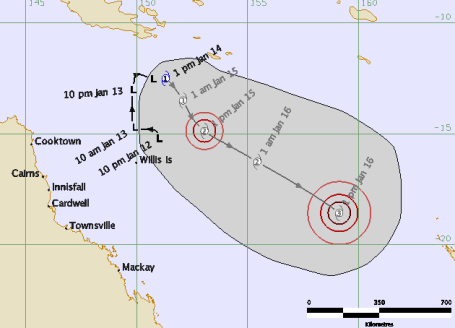
Cyclone Zelia To Spare Australia? Queensland, in northeastern Australia, has seen the equivalent of 1-2 hurricane's worth of rain in recent week, resulting in some of the worst flooding ever witnessed "down under." That's why locals are probably breathing a huge, collective sigh of relief - Cyclone Zelia (same thing has a Category 3 hurricane) is moving away from Queensland, tracking toward a possible landfall over New Zealand. From
cairns.com: "
Tropical Cyclone Zelia is predicted to intensify into a category 3 system as it moves away from the Queensland coast over the next two days. The weather bureau officially named TC Zelia earlier today after it developed from a tropical low overnight."
Hurricane Season Down Under. Hurricanes are called cyclones in the Indian Ocean (and off the coast of Australia), typhoons in the western Pacific. Right now weather models take Cyclone Zelia southeast, on a path toward New Zealand.
Zelia Track. The Australian Weather Service weather models take the storm away from Queensland in the coming days, a little close for comfort.
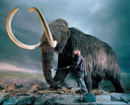
Re-creating Jurassic Park. What Can Possibly Go Wrong? Plans to clone a woolly mammoth? Sounds like a sound business plan to me. More from a head-scratcher of a
story at geekosystem.com: "
Life finds a way, and sometimes that way is a curious and determined scientist. Professor Akira Iritani is one such man. He says that the technological hurdles in the way of cloning a healthy mammoth have mostly been overcome. Iritani plans to travel to Sibera this year to seek out mammoth remains, either by searching for it himself, or, if that fails, asking Russian scientists if they’ve got any on hand. But after that it’s simply a matter of finding a healthy nucleus, inserting it into the cells of a female African elephant, and waiting out an almost two year gestation cycle."
Trust me. This will end badly.
Anderson Cooper As You've Never Seen Him Before. In case you missed SNL Saturday night, there was a funny clip with CNN's Anderson Cooper (who I've met, for what it's worth. He's amazing shy and introverted when the camera is turned off, but I'm a fan). What happens when you combine Anderson, Pee Wee Herman, Andy Samberg, and way too much tequila? It's not pretty - but it is pretty funny. Check out the (PG-rated) mediaite.com clip
here.
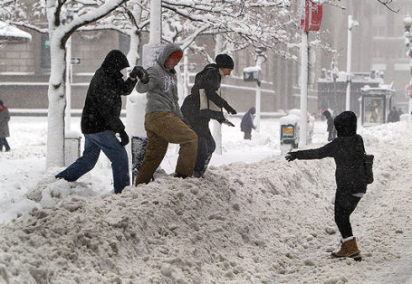
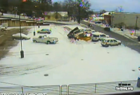 Snow Plow Parking Ramp FAIL
. I think I know this guy! Wonder if he got overtime for this. An example of really bad snow-plowing
here, courtesy of those rascals at failblog.org.
Global Paradox
"It's cold outside, therefore global warming and climate change is a scam, right?" It may be human nature to look outside and assume the entire planet is experiencing the very same conditions. What is happening, and why?
Proving cause and effect is tricky, but since December the atmosphere has been locked in a blocking pattern, a holding pattern. It's called the "North American Oscillation"; scientists believe we're in a negative phase. Warming of the Arctic region is melting sea ice. Open water during the winter allows heat to flow from oceans to the atmosphere, creating high pressure over the Arctic, forcing the colder air that should be over the North Pole south, into North America and Eurasia. As Jeff Masters from Wunderblog explains, "it's kind of like leaving the refrigerator door ajar, the 'fridge warms up but, cold air spills into the house." Superimposed on all of this: a strong La Nina (cooling phase of the Pacific), which favors colder, snowier weather for the eastern USA.
Clippers today and Saturday may drop 1-2", no big deal. Expect 3 subzero nights this week, it won't be as bad as we thought a week ago. In fact a thaw is possible the middle of next week. 32F !
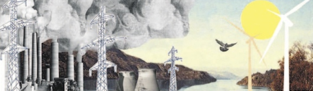
Recession Special: Cleaner Air. There were a few tangible benefits to the Great Recession of 2008-2009, as
reported by the New York Times: "The previous Congress failed to pass
climate change legislation, and the new House is openly hostile to the idea. But what the government has not mandated, the economy is doing on its own: emissions of
global warming gases in the United States are down. According to the Energy Department, carbon dioxide emissions peaked in this country in 2005 and will not reach that level again until the early 2020s. “It’s important to note that the future isn’t what it used to be,” said David Doniger, policy director of the Climate Center at the Natural Resources Defense Council. He pointed out that the Energy Department’s projection of emissions in 2020 was lower in 2008 than in 2007, and has kept falling. How could that be? In part, the Great Recession has been good for something."
If Quakes Weren't Enough, Enter The "Superstorm". The rains have eased across California in recent weeks, flooding detoured northward into Oregon and Washington State. But residents of California shouldn't be complacent, as this New York Times
story points out: "
California faces the risk not just of devastating earthquakes but also of a catastrophic storm that could tear at the coasts, inundate the Central Valley and cause four to five times as much economic damage as a large quake, scientists and emergency planners warn. The potential for such a storm was described at a conference of federal and California officials that ended Friday. Combining advanced flood mapping and atmospheric projections with data on California’s geologic flood history, over 100 scientists calculated the probable consequences of a “superstorm” carrying tropical moisture from the South Pacific and dropping up to 10 feet of rain across the state."
Hotter. Colder. Wetter. Is the spasm of extreme weather events we're witnessing all around the world simply coincidence, or tangible symptoms of something more? Australia's theage.com has a
story here that attempts to put this brave, new (extra-stormy) pattern into perspective: "
In A land of droughts and flooding rains, it's often hard to remember when you're being scorched by one or submerged by the other. But lately Australia seems to be oscillating between increasingly regular and ruinous extreme weather events - and sometimes suffering the opposite ends of the extremes at the same time. So one side of the continent is inundated by the worst floods in memory, while its south-west corner is hit by bushfires. Is this the future? Are these a sign of things to come with climate change? The short answer, from a range of experts consulted by The Sunday Age, is yes and no."
Delicate Planet. A timely book
review from the New York Times: "
This has been a dismal year for the health of our planet. Evidence of human-caused catastrophe mounts daily with grim reports from sea, sky and land: disappearing species, the collapse of fisheries, deforestation, the shrinking ozone layer, higher concentrations of atmospheric carbon dioxide, oceanic dead zones, warming temperatures, extreme weather, rising sea levels, depleted aquifers, melting glaciers, thawing permafrost. We have already crossed into an unimaginable new epoch, but we seem unable to unite behind efforts to change, or even slow, our disastrous course. Why are we in such denial?"
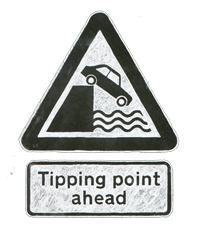
Climate Change Could Happen Much Faster Than Previously Thought. Are we near a true tipping-point? I don't pretend to know, but a number of scientists are concerned. Here is a
post from the Morung Express: "
Humans are in danger of making large parts of the Earth uninhabitable for thousands of years because of man made climate change, according to new evidence based on geological records. The US study predicted that if society continues burning fossil fuels at the current rate, atmospheric levels of carbon dioxide could rise from the current level of 390 parts per million (ppm) to 1,000 by the end of this century. The last time the world had such high levels of carbon dioxide temperatures were on average 29F(16C) above pre-industrial levels. Evidence has been found of crocodiles and palm trees at the Poles and only small mammals were able to survive."
On Our Radar: India's Warmest Year On Record. 2010 was the 21st warmest year since 1880 for the United States, but at least 19 nations worldwide experienced their warmest temperatures on record. India had a sizzling year, as
described by the NY Times: "
The past year was India’s warmest since record-keeping began in 1901, the authorities say, with average temperatures reaching nearly 77 degrees Fahrenheit. “This is a definite impact of global warming,” says the director of the Indian Meteorological Department. “Warming started around 1970 but the real impact has been felt only in the last 10 years.” [Times of India] If current emissions continue unchecked, atmospheric carbon dioxide concentrations by the end of the century could reach levels not seen in at least 30 million years, when Earth’s temperature was more than 25 degrees Fahrenheit warmer than today, a study published in the journal Science suggests. “If we don’t start seriously working toward a reduction of carbon emissions, we are putting our planet on a trajectory that the human species has never experienced,” the researcher behind the study says. [University Corporation for Atmospheric Research]"


No comments:
Post a Comment