Paul's Conservation Minnesota Outlook for the Twin Cities and all of Minnesota:
TODAY: A cold start. Coating of flurries. Winds: SE 8-13. High: 12
SUNDAY NIGHT: Steadier, heavier snow - roads getting slippery. Low: 10
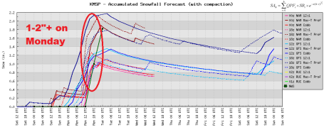
MONDAY: 1-2" snow possible, roads becoming slick. More than 3" possible over southeastern MN. Expect a slow AM commute. High: 26
TUESDAY: Mostly cloudy, turning windy and colder. High: 6
WEDNESDAY: Numbing sunlight, feels like -25 F. Low: -9. High: 8
THURSDAY: Flurries, a harsh wind blows. Low: -3. High: 4
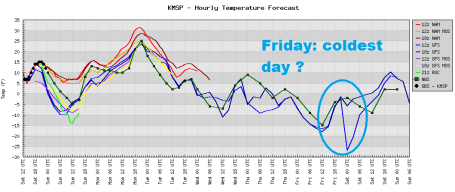
FRIDAY: Some sun, subzero most of the day. Coldest low temperature of the winter? Low: -12. High: 2
SATURDAY: Character-building cold. Clouds increase during the day. Low: -7. High: 7
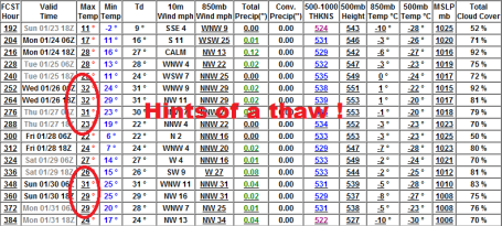
* Computer models are hinting at 20s, possibly even a few low 30s next week, the last week of January.
Primetime Wintertime. This is it - what will probably wind up being the coldest week of winter. Probably no records, nothing we haven't endured (countless) times before. Highs hold in single digits from Tuesday through Friday, as many as 3-5 subzero nights - in fact daytime highs probably won't climb above zero over most of central and northern Minnesota the latter half of the week. This cold wave will be preceded by a Monday clipper capable of a couple inches, potentially plowable. Good thing it's a holiday for most - Martin Luther King Jr. Day. Celebrate by building a snowman, digging out the skis or snowboards - maybe fire up the snowmobile? Monday temperatures will still be tolerable (20s). By midweek only the hardiest of souls will be spending serious time outdoors.
*
So far this winter 52.4" snow has fallen on the Twin Cities. To put that into perspective, that's more snow than fell every single winter since 2003-2004, when 66" fell. See 120 years of snowfall totals for MSP
here, data courtesy of the MN State Climate Office.
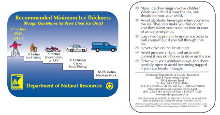
Ice Safety. Yes, it's been plenty cold since the second week of December (with a few days of rain, 30s in late December). But heavy snow earlier in December (a good insulator) means that ice froze unevenly on many Minnesota lakes. Click
here to review DNR safety tips before venturing out onto the ice. Remember, you need at least 5" of safe ice for snowmobiling, 8-12" for a vehicle. Local resorts have a pretty good idea how thick the ice is on your favorite lake. Call ahead to get more information - and avoid unpleasant surprises on the ice. A full-screen pdf of this graphic is
here.
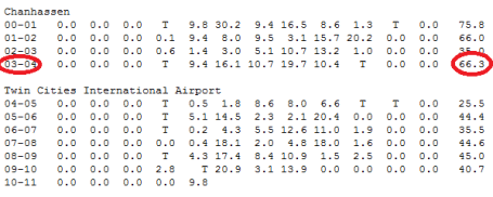
Friday Amounts. Anywhere from 1-3" snow fell across most of the metro area Friday, but the timing couldn't have been much worse (during PM rush). More than 6" caked north central Wisconsin, amounts increasing north/east of the Twin Cities and St. Cloud. More from the Chanhassen office of the National Weather Service
here.
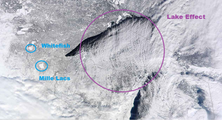
High-Res Saturday Satellite. NASA's "Terra" satellite, orbiting about 200 miles above the ground, snapped
this (amazing) high-resolution image (1,000 meters) around midday Saturday, skies clearing north/east of MSP, thick clouds over southwestern Minnesota. Check out the bands of snow forming over Imostly ice-free) Lake Superior as 5 degree air temperatures passed over 35-38 F. water temperatures. I've seen lake effect snow bands southeast of Mille Lacs and even the Whitefish chain. Minnetonka and White Bear are a little too small for lake effect, not enough of a "fetch" of cold air over relatively warm air. It wouldn't matter now anyway, since all of Minnesota's lakes, exept for Superior, are covered in 7-11" of ice.
Monday Headaches. Why should the start of the coldest week of winter be easy? The arrival of Arctic air will spin up a clipper Sunday night and Monday morning, models hinting at 1-2", maybe more than 3-4" for parts of southeastern MN - possibly enough to shovel and plow (and gum up the morning commute). The farther south you travel on I-35 the worse conditions may be - models hinting at 4-8" amounts for southern Iowa and northern Missouri.
Monday Clipper. Our next weather-maker will track just south of Minnesota Monday, moving too quickly to tap significant moisture from the Gulf of Mexico. But models print out .15" of liquid precipitation. A rain/snow ratio of 12/1 or 13/1 should result in 1-2" for much of the metro area, maybe more across southeastern MN.
Tricky Monday? Lately we've seen what a lousy inch or two of snow can do (especially at rish hour - when the temperatures is cold). I think 1-2+" is a reasonable range, most of that coming late Sunday night and Monday morning. The good news: temperatures should be in the mid to upper 20s (meaning the chemical mix put down by MnDOT has a prayer of actually working and keeping freeways/interstates mostly wet/slushy). More good news: after Monday's snow event (hesitate calling it a "storm") it should be cold - but dry the rest of the week.
Coldest Week of Winter? Yes, we had a few cold days the second week of December (two single-digit "highs", 3 nights below zero, as cold as -8 at MSP) but I think this week will be colder, an all probability the coldest week of the winter season. Not exactly record territory, but from Tuesday through Friday temperatures run a good 15 degrees below average, dipping to -15 in the Twin Cities suburbs by the end of the week (Friday appears to be the coldest day). Up north some -40s are a pretty sure bet by the end of the week. Great fun!
Reason To Be (Cautiously) Optimistic. O.K. The GFS keeps flip-flopping. Tomorrow (once again), our much-anticipated, much-needed thaw may evaporate, but there seems to be SOME consistency from run to run now. Confidence level is low to moderate (but rising) that we'll see some sort of warming trend the last week of January. We're due for a few 30s. Once we muddle through a miserably cold week, it's all uphill from there...
Government Winter Travel Warning
Various government ministries have suggested that anyone traveling in the current icy conditions should make sure they have the following:
Shovel
Blankets or sleeping bag
Extra clothing, including hat and gloves
24 hours worth of food
De-icer
Rock salt
Flashlight with spare batteries
Road flares or reflective triangles
Empty gas can
First Aid kit
Booster cables
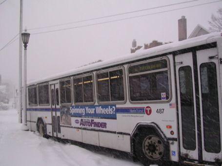
Boy oh boy, I looked like an idiot on the bus this morning...
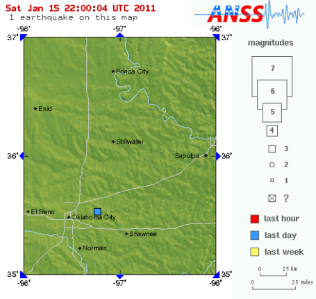
Oklahoma Tremor. This
story caught my eye - another (minor) earthquake in...Oklahoma? From the AP: "
People near Oklahoma City were shaken awake by a small earthquake before dawn. The U.S. Geological Survey says the earthquake happened just before 5 a.m. Saturday. Its epicenter was about 15 miles east of Oklahoma City. The USGS website says the earthquake measured a preliminary magnitude of 3.4. People have reported feeling it up to 21 miles away in Edmond. No damage was reported."
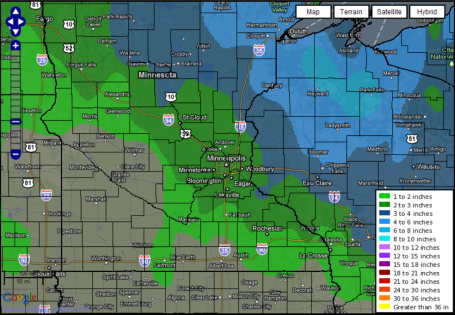
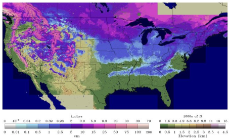
Growing Spring Flood Potential.
Here is the latest
snow water equivalent map from NOAA's National Snow Analyses division in Washington D.C. That looks like 6" of liquid water equivalent trapped in the 30"+ of snow on the ground over western Minnesota - near Granite Falls and Montevideo. The potential for river flooding on the Red and Minnesota rivers will depend on a multitude of factors: how much additional snow falls, how quickly the snow melts in March, whether a thaw is accompanied by heavy rain, etc. But right now, based on how much snow has fallen, the water locked up in that snowpack, and the prospect of another 25-30" by April (if we just get "average" snow the rest of the winter season) I have a bad feeling about spring flooding across Minnesota. Hope I'm wrong on that score.
Earth Twice As Dusty As 19th Century.
This article at syfy.com caught my eye: "
If your house seems dustier than usual, it may have nothing to do with your housekeeping skills. The amount of dust in the atmosphere has doubled over the last century, according to a new study, and the dramatic increase is influencing climate and ecology around the world. The study, led by Natalie Mahowald, associate professor of earth and atmospheric sciences at Cornell University in the US, used available data and computer modeling to estimate the amount of soil particles in the air throughout the 20th century. It's the first study to trace the fluctuation of a natural (not manmade) aerosol around the globe over the course of a century, according to a Cornell statement."
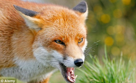
Fox Shoots Man. You've heard the old adage: "When a dog bites a man, that's not "news". But when a man bites a dog, that is!" It's a (mercifully) slow news-cycle, so I bring you an odd little
story from the U.K.'s Daily Mail: "
A hunter became the hunted after a fox managed to shoot him with his own gun. The stricken animal somehow pulled the trigger of the man’s shotgun with its paw, hitting him in the leg. The bizarre incident happened as the unnamed 40-year-old hunter tried to kill the fox with the butt of his gun after shooting it from a distance."
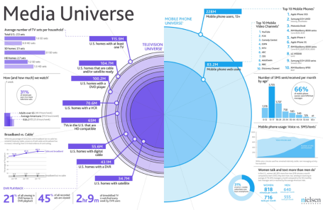
Factsheet: U.S. Media Universe. I found this to be a compelling graphic from the Nielsen rating folks. Click
here to see the full-screen version. The story, and more bullet points,
here. A few highlights:
Fast Facts:
- Average Number of TVs per U.S. Household: 2.5
- Percentage of Americans with 4 or more TVs: 31%
- Number of Mobile Phone Users (13+): 228M (!)
- Percentage of U.S. Mobile Subscribers with Smartphones: 31%
- Number of mobile phone web users: 83.2M
 Stuxnet. Using "Worms" As Geopolitical Weapons
. Click
here to read a fascinating New York Times article about how a computer "worm" (virus) planted by a variety of (U.S. friendly) nations and corporations may have set Iran's nuclear ambitions back by several years. An excerpt: "
The Dimona complex in the Negev desert is famous as the heavily guarded heart of Israel’s never-acknowledged nuclear arms program, where neat rows of factories make atomic fuel for the arsenal. Over the past two years, according to intelligence and military experts familiar with its operations, Dimona has taken on a new, equally secret role — as a critical testing ground in a joint American and Israeli effort to undermine Iran’s efforts to make a bomb of its own. Behind Dimona’s barbed wire, the experts say, Israel has spun nuclear centrifuges virtually identical to Iran’s at Natanz, where Iranian scientists are struggling to enrich uranium. They say Dimona tested the effectiveness of the Stuxnet computer worm, a destructive program that appears to have wiped out roughly a fifth of Iran’s nuclear centrifuges and helped delay, though not destroy, Tehran’s ability to make its first nuclear arms."
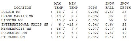
Chilling Saturday. It was a cold one out there yesterday, temperatures 5 to 8 degrees colder than average. MSP has 13-14" on the ground, 14" at St. Cloud, 19" Rochester and a whopping 23" up at Duluth.
Dreaded Hassle Factor
52.4" so far this winter in the Twin Cities. That's twice as much as we saw last year, to date, and twice our normal snowfall as of January 15. Just once I'd like to see "normal" weather. Maybe I'm just imagining it, but highway conditions are (much) worse than I can remember. In spite of Herculean efforts from MnDOT crews, I-494 resembled a logging trail up at the Boundary Waters Canoe Area Friday afternoon; it took me nearly 2 hours to get from Excelsior to MSP International. Is the budget shortfall affecting the number of plows on the highways, or is this just a matter of bad timing, "bursts" of snow coinciding with rush hour?
My hunch: ill-timed storms coupled with bitter cold, making snow removal much harder. My Hassle Factor ("1" means smooth sailing, "5" suggests parking lot conditions), is a first attempt to quantify the fact that a storm's ultimate impact depends on a) amounts, b) timing, and c) air temperature. Cold snowfalls are the most problematic.
Another clipper dumps 1-2+" Monday, the AM commute a "3" on the Hassle Factor. Next week should be the coldest of the winter, a streak of single-digits highs. The good news: a thaw arrives the last week of January!
NOAA Using Gulfstream IV To Probe Winter Storms. No, this fancy jet isn't a play-thing for a CEO. You can only gather so much data from weather satellites and balloons. A recent
press release from NOAA: "
NOAA has dispatched one of its highly specialized aircraft to collect atmospheric data over the North Pacific Ocean to enhance forecasts of winter storms for the entire North American continent. NOAA’s high-altitude, twin-engine Gulfstream IV-SP jet will be stationed at Yokota Air Force Base in Japan through February before repositioning to Honolulu in March. From these locations, the aircraft will be tasked by the National Centers for Environmental Prediction — a division of NOAA’s National Weather Service — to collect information such as wind speed and direction, pressure, temperature and humidity. The data will be sent via satellite to global operational weather forecasting centers and fed into sophisticated computer forecast models."
Climate Change Deniers Skillfully Fuel Doubt. Yes, it's cold out there. But try not to look out the window and make (long-term) assumptions for the entire planet. For that information I defer to the true experts: climate scientists, who monitor satellites and ground-based observations. An estimated 97% of the peer-reviewed experts, the people who make a living tracking long-term temperature and moisture trends, believe that a). temperatures are still rising, and b). much of the warming can be traced to the 38-39% spike in greenhouse gases since the dawn of the Industrial Revolution, most of the carbon dioxide, methane and other greenhouse gases released in the last 50 years.
Here's a timely
story from the Edmonton Journal: "
Historian Erik Conway did two things this week that might seem counterintuitive, if not downright odd. He voluntarily left the warmth of Pasadena, Calif., where he works at NASA's Jet Propulsion Laboratory, to come to Edmonton during the middle of a bitter cold snap. And while here, as thousands of Edmontonians coaxed their cars to life for the frigid commute home through snow-choked roads, Conway entered a lecture hall at the University of Alberta to present a lecture on global warming. Conway understands, as do climate scientists around the world, that a cold snap in Edmonton does not negate the science of global warming that takes into account the worldwide climate over a span of a century and a half. But he also understand how it's simple human nature for each of us to focus on the evidence under our noses -- and in Edmonton on Thursday that evidence included frozen cars, ice scrapers and frost nip. Just thinking of global warming seemed counterintuitive. For people with a shaky notion of climate change, frigid days like this probably raise doubt. That doubt is exploited by those who deny the science of climate change, (people such as U.S. Senator Jim Inhofe whose family built an igloo during the blizzard in Washington, D.C., last year and sarcastically labelled it "Al Gore's New Home").


No comments:
Post a Comment