Hassle Factor Today - Friday: 3. (bitter wind chills coupled with a coating of flurries, potential for "black ice")
Today: Wind Chill Advisory.....potentially dangerous wind chills (dipping to -25 at times).
Coldest air temperature: Friday morning (-15 to -20 F. in the metro area). Some -30s over central Minnesota.
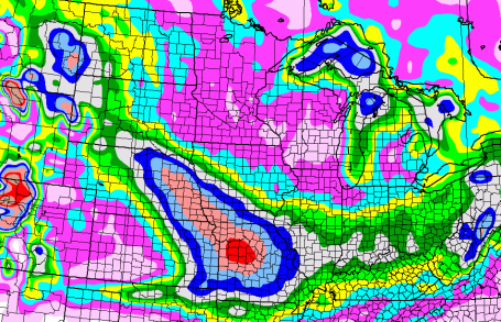
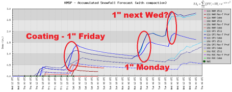
Snow Outlook: coating - 1/2" powder possible Friday, 1-2" next Monday - no big storms in sight.
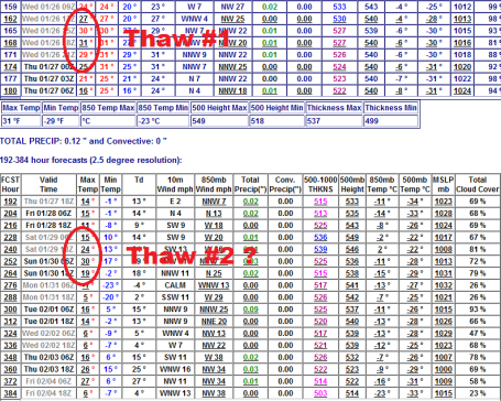
Thaw? Chance of highs near 32 F. next Wednesday, again the last weekend of January.
Diane Frolov and Andrew Schneider, Northern Exposure, Lost and Found, 1992, courtesy of quotationspage.com.
- From my friend, Sharon Bertrand, Mendota Heights (received Wednesday afternoon)
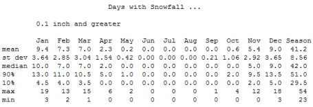
Average Number of Snowfalls at KMSP:
1"+ 15.7 days
2"+ 8.3 days
4"+ 3 days
6"+ 1.3 days
8"+ .5 days
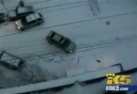
Skating Rink. O.K. My senior memory can't recall if I included this link from KING-TV in Seattle, but it shows the sheer impossibility of maintaining any semblance of control on glaze ice. This is from the Portland area, the You Tube clip has picked up more than 641,000 views - once you see the video you'll know why (and have a new respect for glaze ice). Good grief.
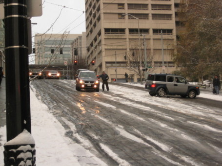
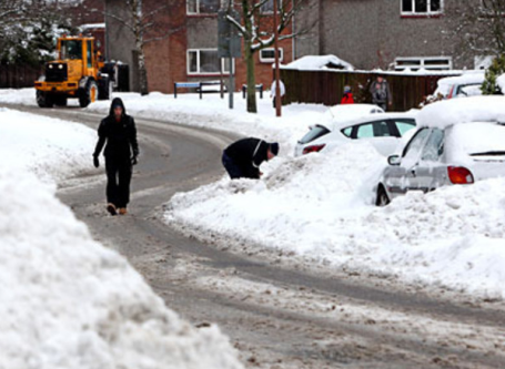
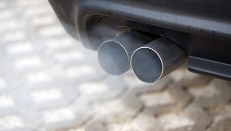
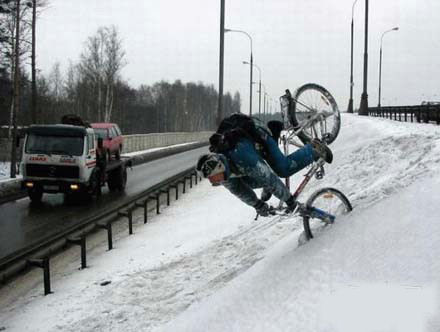
The Perils Of Black Ice. When it's this cold water from vehicle exhaust (which normally evaporates) can acclimate, freezing directly onto highway surfaces. You can wind up with a thin glaze of sheer ice, even when skies are crystal clear overhead. The phenomenon is most common near intersections and ramps, where cars and trucks idle for long periods of time (yes, hydrocarbons in that blue exhaust smoke are conspiring to make your commute even trickier). Not much you can do - chemicals put down by MnDOT don't work nearly as well at or below zero. The only thing you can do is a). leave more room between you and the vehicle in front of you, and b). slow down. Stuff your Dad taught you when you were 16 and just learning to drive. From Wikipedia: "Black ice, sometimes called glare ice or clear ice, refers to a thin coating of glazed ice on a surface. While not truly black, it is virtually transparent, allowing black asphalt/macadam roadways to be seen through it, hence the term "black ice". The typically low levels of noticeable ice pellets, snow, or sleet surrounding black ice means that areas of the ice are often practically invisible to drivers and thereby do not serve as a good indicator that they should reduce their speeds. Similar thin invisible layers of ice that form along ships can cause them to become unbalanced. In the mountains, black ice is referred to as verglas and is a great hazard for climbers."
From The National Weather Service:
...BLOWING SNOW AND DANGEROUS WIND CHILLS ON THURSDAY INTO FRIDAY...
.A WINTER WEATHER ADVISORY FOR BLOWING SNOW HAS BEEN ISSUED FOR PARTS OF WEST CENTRAL AND SOUTH CENTRAL MINNESOTA FROM 9 AM THURSDAY TO 9 AM CST FRIDAY...GENERALLY WEST OF A MOTLEY...TO LITCHFIELD...TO ST JAMES LINE. A WIND CHILL ADVISORY HAS BEEN ISSUED FOR THE REMAINDER OF CENTRAL AND SOUTH CENTRAL MINNESOTA AND WEST CENTRAL WISCONSIN FROM LATE THURSDAY AFTERNOON AND EVENING UNTIL 9 AM CST FRIDAY.
A STRONG COLD FRONT WILL BLAST FROM WEST TO EAST ACROSS THE AREA ON THURSDAY...AND BRING STRONG NORTHWEST WINDS AND FALLING TEMPERATURES THROUGHOUT THE DAY. WINDS OF 20 TO 30 MPH WILL RESULT IN BLOWING AND DRIFTING SNOW AND REDUCED VISIBILITIES ACROSS WEST AND SOUTH CENTRAL MINNESOTA FROM LATE MORNING THURSDAY INTO THURSDAY NIGHT. WIND CHILL TEMPERATURES WILL BECOME DANGEROUS ACROSS ALL OF CENTRAL AND SOUTH CENTRAL MINNESOTA AND WEST CENTRAL WISCONSIN ON THURSDAY AFTERNOON AND EVENING...WHEN WIND CHILL TEMPERATURES OF 25 BELOW TO 35 BELOW WILL BECOME COMMON. ALTHOUGH WINDS WILL DECREASE NOTABLE ON THURSDAY NIGHT INTO FRIDAY AND REDUCE THE THREAT FOR BLOWING SNOW...EXTREMELY COLD AIR TEMPERATURES WILL PROLONG THE THREAT OF DANGEROUS WIND CHILLS INTO FRIDAY MORNING.
LOW WIND CHILLS WILL RESULT IN FROST BITE AND LEAD TO HYPOTHERMIA IF PRECAUTIONS ARE NOT TAKEN. IF YOU MUST VENTURE OUTDOORS...MAKE SURE YOU WEAR A HAT AND GLOVES.
U.S. Pond Hockey Championship. This is a really big deal, a few hockey-fanatics in the WeatherNation office tell me that a few NHL stars and college champions will be participating at Lake Nokomis this year. If you've never been to one fo these you need to check it out. Here is the Mother Lode of information about this weekend's events and festivities. Good news on the weather front: peeks of sun Saturday and Sunday, not quite as cold as today or Friday. No rain this year either! Last year nearly .25" of rain spoiled the fun - the tournament had to be delayed because of a freak midwinter rain storm. No worries this year.

St. Paul Winter Carnival Preview. Hard to believe, but the "coolest celebration on Earth" kicks off a week from today in and around St. Paul. Although temperatures may be close to freezing next weekend I don't see any fun-killing warm fronts, nothing that will cause Boreas any real concern into early February. We'll keep an eye on the forecast, but right now it looks like temperatures may be perfect: no painful cold fronts, but just chilly enough to keep those (amazing) ice carvings in Rice Park intact and picture-perfect.
A Gentle Reminder Of Things To Come. Call me crazy, but this year (more than any year I can remember) I am REALLY looking forward to the Boat Show at the Minneapolis Convention Center. It kicks off today, runs through Sunday. Just walking the floor, seeing pictures of happy people on boats, pontoons, kayaks - anything - will make you smile. That's my prediction.
Consequently, policies are all over the map:
•In International Falls, Minn., the self-described "Icebox of the Nation," where the average high temperature in January is a frosty 13 degrees, Falls Elementary School Principal Jerry Hilfer says, "if it's 15 below (or warmer), they go out, no matter what."
"At 20 below, it gets iffy," he adds.
•In Upper Marlboro, Md., at Mattaponi Elementary School, the school website says students have outdoor recess unless the temperature drops to the 35 and 40 degree range.
•Elsewhere in Minnesota, many other schools do not send students outside for recess if the temperature is below zero. That's been the standard at Lincoln Elementary in St. Cloud, Minn., for as long as anyone can remember, Principal Chris Blauer says. Wind chill also is considered, she says.
•If it's above zero, all students at Pine Meadow Elementary in Sartell, Minn., are expected to come to school dressed properly to go outside, Principal Greg Johnson says. Spending some time outside every day makes students better learners in the classroom, he says.
"Students need that time," Johnson says. "The fresh air and exercise are really important."
•In Wicomico County, Md., principals typically keep children indoors when temperatures dip below freezing, or if it's raining or snowing, says Susan Jones, the school system's director of elementary education.
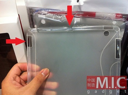
"M.I.C Gadget has a great set of photos of what they believe to be a form fitting clear case for the as yet unannounced iPad 2. You can see one of the photos reproduced to the left here.M.I.C. Gadget’s Chris Chang speculates that the case holes could indicate the addition of a video output (HDMI or mini-HDMI) and an SD slot. Both would reduce the number of iPad peripherals I need to carry around and would be welcome additions."
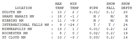
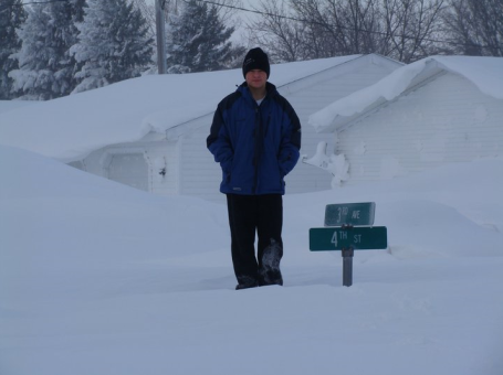
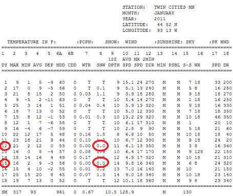
Fresh Air. 24 below zero at International Falls Wednesday morning, highs in single digits and teens statewide, a good 10 degrees cooler than average. Officially 2/10ths of an inch of snow coated the ground at the Twin Cities, St. Cloud and Rochester.
Paul's Conservation Minnesota Outlook for the Twin Cities and all of Minnesota:
TODAY: Windchill Advisory. Few flurries. Wind chill: -20 to -25 F Winds: NW 20. High: 8
THURSDAY NIGHT: Partly cloudy and bitter, possibly the coldest night of winter. Low: -15
FRIDAY: Coldest day of winter? Coating of flurries possible. High: 4
SATURDAY: Patchy clouds, worst is over. Low: -7. High: 8
SUNDAY: Intervals of sun, partly-numb. Low: -9. High: 10
MONDAY: Next clipper, 1-2" possible. High: 24
TUESDAY: Flurries taper, colder wind. High: 17
WEDNESDAY: Clouds linger, 20s feel pretty good. High: 23
Bone-Crushing Cold
"Time for the weather report. It's cold out folks. Bone-crushing cold. The kind of cold which will wrench the spirit out of a young man, or forge it into steel." That was from a "Northern Exposure" episode back in '92, but it eloquently sums up the next 48 hours. The core of the Arctic air arrives today, a stinging wind will make it feel like -25 to -30. The coldest air temperatures arrive early Friday, when the mercury bottoms out in the -15 to -20 F. range in the Twin Cities.
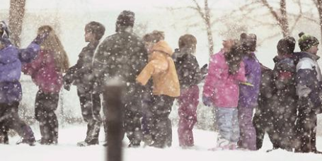
Too cold for recess? That's a loaded question. What works in the Twin Cities won't work in Atlanta. But if your child has multiple layers (little or no exposed skin) AND they're physically active, a chill factor of -10 isn't necessarily dangerous. When clothing gets wet, or gloves come off, the risk of frostbite can set in quickly, within 10-15 minutes. Common sense applies.
We've had only 2 snow-free days at MSP in January, but no big storms are brewing; the main storm track shoved 500 miles south. A family of clippers arrive Friday, Monday and Tuesday. No rain for the U.S. Pond Hockey Championship at Lake Nokomis this year - last year .25" rain fell. Plenty of (solid) ice this year.
Think warm thoughts!
A Bad Climate For Global Warming. A recent story from the Boston Globe: "Last week the National Oceanic and Atmospheric Administration and NASA’s Goddard Institute for Space Studies announced that 2010 had registered as the hottest year on record. Nothing new here: nine of the last 10 years have been among the warmest ever. The news highlighted one of Washington’s biggest failures over the last two years: its inability to advance climate legislation. It was also a grim reminder that things could get worse. Some crucial policy areas have always been neglected and some initiatives stalled. But rarely has a first-order concern like the nation’s climate and energy policy actually regressed — and so dramatically as we’ve seen since the last presidential election."
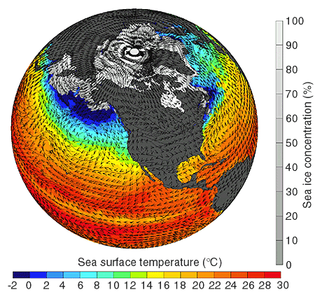
Too Little Ice Could Be Adding To Global Warming? Counterintuitive (as we shiver our butts off)? Absolutely. But changes in atmospheric and ocean currents over far northern latitudes may be at least partially responsible for some of the crazy (cold/snowy) weather we're "enjoying" at this latitude. From a recent story in the Washington Post: "Scientists are reporting that the shrinking ice and snow cover in the Northern Hemisphere is adding to the problem of global warming in a way that they had not anticipated. Arctic sea ice, glaciers and snow are reflecting less energy back to space than they were 30 years ago, according to a University of Michigan study. Scientists say that what was once covered in ice and snow is now land and water, which are darker and absorb more heat than the white ice. As a result, the amount of solar energy being reflected to the Earth's upper atmosphere has decreased since the late 1970s. Scientists add that other factors could be causing the decrease but that the decline is more than they had expected."

A Brief Lesson In The Integrity Of Science: Climate Scientists Challenge Bad Science, No Matter The Source. This story from water and climate scientist Peter Gleick on Huffington Post caught my eye yesterday: "All scientists are, by definition, skeptics. Hence the motto of the Royal Society of London, one of the world's oldest scientific academies (founded in 1660), Nullius in verba: "Take nobody's word." Skeptics and good scientists question and change their minds when presented with competing and convincing evidence. Indeed, scientific reputations are made by identifying flaws in current thinking, developing and testing new hypotheses, and by being right, not wrong. And while all scientists (and all people) make mistakes, good ones acknowledge their mistakes, correct them, and refine our knowledge. Bad ones dig in their heels, defending a faulty paradigm to the bitter end. While a huge amount of effort is put into debunking the bad science promoted by climate deniers, scientists work to correct errors in understanding about climate on all sides. Here is a good example of honest climate science at work, in this case to correct a technical error in a report from an Argentinean food security NGO overstating some climate risks."
"Nobody expects the incoming Congress to take dramatic action on climate change, just as nobody was surprised that the international leaders meeting in Cancun couldn’t reach strong, binding agreements to reduce greenhouse gas emissions. And it’s no wonder – reinventing our whole relationship to energy and the environment is a major challenge, with profound moral and economic implications. But despite the glacial pace of leadership at the top, there are many reasons why real global action on climate change is inevitable.
Here’s 10 trends to watch in 2011 that are driving action on climate change :
Dramatic Weather Events Make an Impression: Heatwaves, fires, storms, and floods are on the rise across the planet. While no single event can be linked directly to climate change, their overall increase is a result of a warmer, wetter climate that is destabilizing the environment worldwide. Every time another “natural” disaster strikes, it makes people painfully aware of the connection between our impact on the environment, and its impact on us.
Food Crises Threaten Global Security: Over a billion people go hungry every day, and as the climate changes, food security is being threatened worldwide. The US Academy of Sciences reports that for every 1 degree temperature rises, crop yields fall 10 percent, so we can’t increase food productivity without addressing climate change. And as Lester Brown of the Earth Policy Institute has long argued – food shortages lead to political collapse, and ultimately failed states which threaten global security."
No comments:
Post a Comment