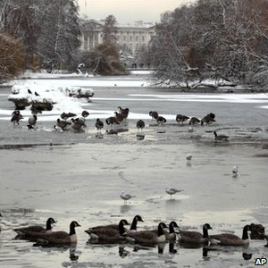
54.2" Snow This Season. .1" snow fell Thursday. We've already picked up more snow in the Twin Cities than any of the 6 previous winters.
Snow on the ground at MSP: 12" (a coating of flurries possible tonight).
Hassle Factor: 4. Dangerous wind chills. Risk of black ice.
Daylight: we've picked up
32 minutes of daylight since the Winter Solstice on December 21. Historically temperatures begin to finally trend upward again the last few days of January, first few days of February.
Heating Degree Days since July 1: 3897. Normal for that same period: 4124 (this means that, believe it or not, we've spent a little over 5% LESS heating our homes and businesses since July in the Twin Cities). Based on heating degree day data from the NWS this winter is running slightly milder than last winter. I know, go figure.
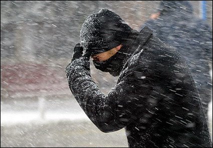
WInd Chill Advisory in effect. A combination of bitter cold and 10-15 mph. winds will make it feel like -20 to -30 F. this morning. Frostbite is possible on unprotected skin within 10 minutes.
Today's Record Low: -29 F. (1970)
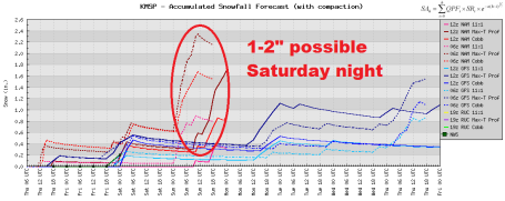
Saturday Night Clipper may drop 3-6" snow on far southwestern Minnesota, a dusting in the metro, maybe 1-2" far southern suburbs Saturday night into early Sunday.
Quality of Life: 97 (highly subjective and subject to change).
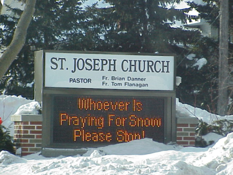
Snow-Weary. Thanks to my friend (and tech guru) Mike Huang from WeatherNation for passing this along, apparently from a church in Milford, Iowa.
A Little Perspective (from Pete Boulay at the MN State Climate Office):
In 2010 the Twin Cities had a low temperature of -15, on January 2.
In 2009 the Twin Cities registered a low temperature of -22, on January 16.
The next coldest: -24 F. on January 30, 2004.
Coldest reading at MSP in recent years? -32 F. on Feb. 2, 1996.
Coldest
Modern-day record at MSP? -34 F. in January, 1936
Coldest
Pioneer record at MSP? -41 on January 21, 1888
It Could Be Much Much Worse. The longest spell of uninterrupted subzero temperatures in the Twin Cities? 186 hours (
almost 8 straight days), from 5 pm December 21, 1911 to 1 pm, January 8, 1912). I can't even imagine what the locals were saying that winter. Glad I wasn't around to find out.
Coldest Day Of The Year, Statistically? January 24
Average Number of Subzero Nights at KMSP? Approximately 30
Average Number of Subzero Days at KMSP? 3
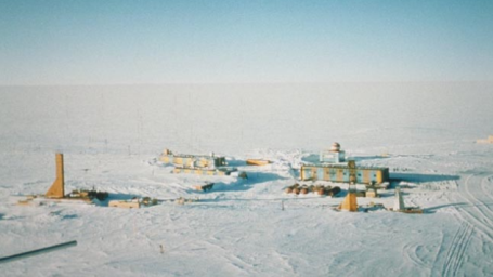
Coldest Places On Earth. Wunderblog's Jeff Masters has an interesting
post about the coldest spots on the planet (places that make Minnesota look like Fort Myers in September). The photo above is the Vostok scientific research facility at Antarctica, 700 miles from the South Pole (elevation 11,444 feet - one vast, icy desert), the most isolated scientific workshop on Earth. Masters writes: "
Weather records have been maintained here almost consistently since it was first established by the Soviets in 1958. It is manned by 25 researchers during the summer months and 13 during the winter. The world’s lowest observed surface air temperature was recorded on July 21, 1983 when a reading of -128.6°F (-89.2°C) was made. Another even colder reading of -132°F (-91°C) was rumored to have been attained during the winter of 1997 but this is unsubstantiated. The single coldest month was August 1987 with a mean temperature of -104°F (-75.4°C). The warmest on record for the site is a surprising 10°F above zero (-12.2°C) on January 11, 2002."
Cold Weather Facts (courtesy of the World Almanac and Book of Facts)
-20 F. Motor oil becomes a thick gel and has much more trouble moving through the engine of a vehicle.
-30 F. Most piston-engine airplanes are grounded because they are prone to a kind of "mechanical hypothermia."
-40 F. Exposed flesh can freeze within 1-3 minutes.
-60 F. Exposed flesh can freeze within seconds.
-60 F. (or colder) Breath turns to ice crystals that fall to the ground. Yikes!
Difference Between "Frost Nip" and "Frost Bite"? I learned something today, researching the blog. Reading this
article about how humans cope with Antarctica, I came across this nugget about "frost nip": "
Most often observed at the end of the nose, tops of the ears or possibly fingers. The skin goes an unnatural looking "pasty white" color and loses sensation. This is caused by a lack of blood flow to those regions because they are losing so much heat. Frost nip is an early warning sign that if left will lead to frostbite. It can be readily corrected however by putting on extra clothing. The skidoo gloves I used in Antarctica had a large patch of sheepskin on the back to hold against and warm up any frost-nipped parts. The important thing with frost nip is to keep an eye on your companions as it is so easy to miss it on yourself. Frost nip can actually freeze the surface layers of the skin and lead to symptoms like sun burn with the warmed skin later turning bright red and being sloughed off. There is no permanent damage."
Are Men More Vulnerable To Frostbite Than Women? More interesting news (from the same article), stuff I didn't know, and feel hopelessly compelled to pass along:
"Cold weather on a modern society has a number of effects, most dramatically on the general population mortality rate. The average mortality on a winter's day is about 15% higher than on a summer's day. Cold weather is directly responsible for deaths through such things as hypothermia, influenza, and pneumonia. It is also an indirect factor in a number of ways such as death and injury from falls, accidents, carbon monoxide poisoning, and house fires all of which are partially attributable to cold.
The sex and race of a person are important when it comes to how susceptible they are to direct cold injury and hypothermia. Non-white elderly men are the most at risk, while white women are the least at risk.
Women have a higher gradient of temperature from the skin to the body core (they're more likely to have cold hands for instance) and so it seems are more able to maintain a constant body core temperature in cold conditions. Subcutaneous fat has a part to play of course as an insulator and women generally have more than do men so helping them stay warm. On the other hand, because of the high temperature gradient from skin to core, women are more likely to suffer from surface cold injury such as frostbite."
So to summarize....women may be (slightly) more vulnerable to frostbite than men, but seem to have better luck with hypothermia, a slow (and sometimes fatal) drop in body temperature.
Urban Heat Island. You've heard this before - the growing season in downtown Minneapolis and St. Paul is nearly 2 weeks longer than the surrounding outlying suburbs. Cities tend to be warmer (yearround) for a variety of reasons. This "urban heat island" is most pronounced during the winter months, especially under a clear sky with light winds (and a temperature inversion capable of trapping warm air over the immediate metro area). The bottom line: temperatures can be 5-15 degrees warmer in and near the downtowns than they are outside the 494-694 freeway. Cold comfort to city-dwellers - it's still going to be numbing out there today, just not quite as extreme as Medina, Ham Lake, Hugo and Lakeville. More from Wikipedia
here: "
There are several causes of an urban heat island (UHI). The principal reason for the nighttime warming is that buildings block surface heat from radiating into the relatively cold night sky. Two other reasons are changes in the thermal properties of surface materials and lack of evapotranspiration (for example through lack of vegetation) in urban areas. Materials commonly used in urban areas for pavement and roofs, such as concrete and asphalt, have significantly different thermal bulk properties (including heat capacity and thermal conductivity) and surface radiative properties (albedo and emissivity) than the surrounding rural areas. This causes a change in the energy balance of the urban area, often leading to higher temperatures than surrounding rural areas."
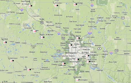
Exhibit A. Temperatures Thursday morning (under a partly cloudy sky) showed a wide range, due to (in part) the urban heat island. MSP International and Crystal reported -3, -2 at Blaine. But Eden Prairie reported -6, -8 at Cambridge, a nippy -11 at Lakeville. See the data for yourself
here.
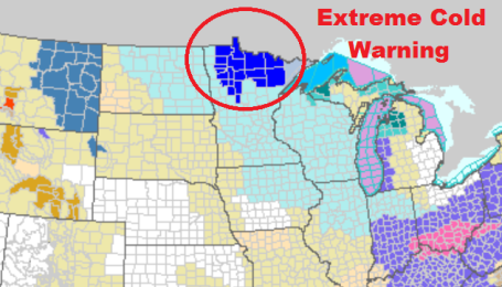
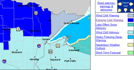
First Operational Use Of New "Extreme Cold Warning". The National Weather Service up at International Falls pulled the trigger on implementing the new warning criteria for dangerously cold weather (even when winds are relatively light). An extreme cold warning is posted for much of northern Minnesota. More details
here.
 Winter Weather Smorgasbord
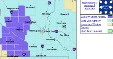
. Something for everyone in this forecast (except warmth). The Twin Cities will be grazed by a Friday clipper, the heaviest snow focused on southwestern Minnesota. Advisories are posted for low wind chill values, but a combination of snow/blowing snow/bitter windchills has lead the NWS to issue a Winter Weather Advisory for much of west central and southwestern Minnesota. The latest advisories are
here.
Saturday night Snowfall? It doesn't look like much (for the immediate Twin Cities metro), but a quick coating of snow is possible Saturday night into Sunday morning as the next (significant) clipper slides off south and west of town. The models are still contradictory, one says a coating to 1/2", another hinting at just over 2". It may be just barely enough to shovel/plow over far southern suburbs.
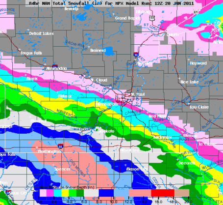
Too Cold For (Heavy) Snow. Don't diss the cold too much - the dome of Arctic air hovering overhead is forcing the main storm track just south of Minnesota. Latest models print out some 4-8" snowfall amounts over far southwestern Minnesota by Sunday, a coating to an inch or two may brush the far southern suburbs of the Twin Cities Saturday night and early Sunday, closer to 3-6" possible as close as Mankato. The farther south you drive on I-35 over the weekend, the worse conditions will become with falling/blowing snow.
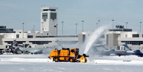
Winter Survival Strategies From The Nation's Snowiest Airports. Have an airport horror story? Most of us do. In the summer it's the risk of thunderstorms - but winter storms are far costlier (to airlines and the psyches of travelers). A
story from USA Today's Travel section: "
Like the plowed snow at many airports, registrations for the 45th annual International Aviation Snow Symposium are beginning to pile up. Held each April, most often in snowstorm-prone Buffalo, the symposium bestows awards on airports that excel in battling the white stuff and offers airport staff a chance to chill out and swap war stories about what went right or wrong, weather-wise, during the previous winter. So far this season, storms have triggered the cancellation of thousands of flights and forced the temporary closing of many airports. That means there'll be plenty to talk about at this year's conference, as attendees try to take in tactics to make you less likely to get stuck at an airport next winter."
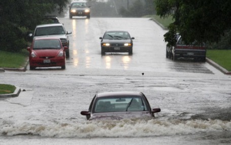
Wall Of Water Swamps Another Australian Town. The worst of the floodwaters have begun to recede across Queensland, but major problems remain. A
stoyr from MSNBC.com: "
A surging river that crested Thursday flooded and isolated a new community as Australia's flood disaster continued. The flooding in Kerang, in the southeast state of Victoria, strained a levee serving as the main protection between the muddy waters and residents' homes. It follows weeks of massive flooding in northeastern Queensland that the government says could be the nation's most expensive natural disaster ever. Overflowing rivers swamped an area larger than France and Germany combined, shut down much of Queensland's lucrative coal industry and left 30 people dead. Walls of water miles wide are surging across northern and western Victoria in the wake of record rainfall last week. Sixty-two Victorian towns have already been affected by rising waters and more than 3,500 people have evacuated their homes."
Thank God She Wasn't At The Grand Canyon. O.K. This is pretty funny (and kind of cruel) at the same time. It shows the hypnotic, awe-inspiring distractions that arise when you're texting (in this case while walking through the scenic Berkshire Shopping Mall). Poor gal, she actually went on TV to complain about having her privacy invaded. Uh huh. This
YouTube clip has 1,739,000-plus views, which tells you something. We are a nation that craves funny (cruel) YouTube videos. Sorry about that. Yes, texting can be a contact sport.
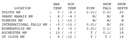
A Fine Arctic Breeze. Hey, at least the sun was out. That helped - on some level. In spite of blue sky the mercury only peaked at 9 in St. Cloud and the Twin Cities, 10 at Rochester, 0 at Duluth and a brisk -3 at International Falls.
 Paul's Conservation Minnesota Outlook for the Twin Cities and all of Minnesota:
FRIDAY: Coldest morning of winter? Yukon sunshine, dangerously cold. Winds: SE 10-15 (feels like -20 to -30 much of the day). High: 2
FRIDAY NIGHT: Cloudy with very light snow and flurries, coating to 1/2" possible. Low: -5
SATURDAY: More clouds than sun, Boat Show in town. High: 6
SATURDAY NIGHT: Still bitter with very light snow or flurries - coating possible (bulk of the snow falls over southwestern MN, where 2-5" may fall). Low: -8
SUNDAY: Good pond hockey weather on Lake Nokomis. More clouds, a bit "milder". High: 14
MONDAY: Flurries taper, peeks of sun. Low: 3. Hiigh: 18
TUESDAY: Some sun, not quite as numbing. Low: 5. High: 22
WEDNESDAY: Risk of a thaw? Slight chance of dripping icicles? Low: 15. High: 30
THURSDAY: Turning colder again, few flurries in the air. Low: 11. High: 15
Numb and Number
So you think THIS is cold? Residents of the sleepy little Siberian town of Oymyakon (population 4,000) would merely shrug. On February 6, 1933 the AIR temperature fell to a hair-freezing -90.4 F. Ouch. Kind of makes this morning feel like a Club Med vacation.
Everything is relative, right? Recent winters have trended milder, especially nighttime lows. The 10 warmest years have been observed since 1998 globally. Here in the Twin Cities the previous 6 winters averaged only 39.3" snow. In a word, we've been spoiled, almost pampered in recent years. Along comes a "real winter" and panic sets in. This too shall pass, but not fast enough for most of us.
Clippers brush the metro with a dusting of snow today, 1-2" Sunday; the pattern not ripe for any commute-crushing snow anytime soon. And long-range models are still hinting at freezing (sound the sirens!) by Wednesday of next week. Too early for spring fever? Absolutely. Models bring another subzero airmass into town the first week of February. We've picked up 32 minutes of daylight since December 21. Sharon Bertrand in Mendota Heights reports "the chickadees are singing their spring song!" It won't be long now. Famous last words.
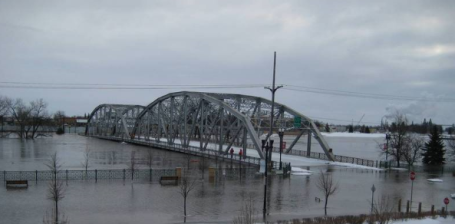
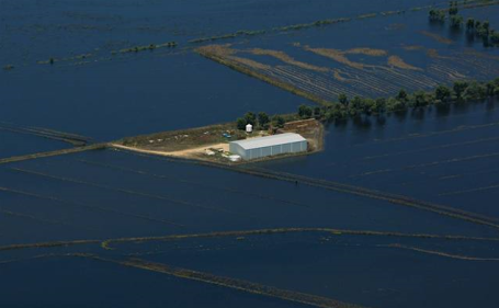
 Major Spring Floods Likely In The Upper Midwest
. An updated
story from USA Today: "
The likelihood of significant Red River flooding has risen in North Dakota and Minnesota, the National Weather Service said Tuesday in its latest outlook for the river that has overflowed the past two springs and sent officials and residents in the densely populated region scrambling to save homes and businesses. There is about a 20-percent chance the river at Fargo and neighboring Moorhead, Minn., will surpass the record crest set in 2009 and about a 50-percent chance it will beat last year's crest, which was the sixth-highest on record, the weather service said. Meteorologist Greg Gust said Tuesday that precipitation levels in the Red River Valley are tracking between the high mark set at this time in 1997, when floods wiped out Grand Forks, about 70 miles north of Fargo, and 2009, when the river eventually crested at nearly 41 feet. Flood stage is 18 feet."
 Under The Gun
. Another flood potential
story from suite101.com:
"
As of January 18, 2011, the National Weather Service predicted that 2011 spring flooding of the Red River Valley will be as bad, and maybe worse, than flooding in both the 2009 and 2010 spring flooding seasons.
The three major factors that are contributing to this year's flood forecasts are:
- Precipitation and moisture content in the soil - the 2010 fall and summer rainfall was 50 percent above average, so the moisture content of the soil is already very high.
- Water in the snowpack - the Fargo area has already received nearly 56 inches of snow so far this winter season, which is nearly 16 inches above its average snowfall for an entire winter.
- Expected spring thaw cycle - the Red River Valley has yet to begin its thaw cycle, which usually begins in late March-early April. If the thaw is quick, the Red River will not be able to accomodate the high amounts of water coming into its banks. Moreover, the ground will remain frozen well into April, so snow melt will have nowhere else to go except into the Red River."
Healthy Skepicism.
Here is a summary of skeptic arguments, sorted by recent popularity vs what science says. Note that the one line responses are just a starting point - click the response for a more detailed response. You can also view them
sorted by taxonomy, in a
print-friendly version, or with
fixed numbers you can use for permanent references.
Fuel Rationing In The U.K.? Brits pondering fuel rationing? When did this happen? Time magazine has more
details here: "
The last time the British government instituted a substantial rationing program was 1940—the Nazis had spread out across Europe and the continent was mobilizing for all-out war. The rationing program, which lasted until 1954, had a profound effect on the collective consciousness of the British public, and is largely remembered not as a time of deprivation but of plucky courage, solidarity and fortitude in the face of a dangerous adversary. So could rationing work again? Today I attended the launch of a report commissioned by the British parliament that called for the rationing of fuel to help meet the government's carbon emission targets and prepare for future fossil fuel scarcity. The report called for an electronic trading system for energy quotas. Such a system is a long way from becoming law, but it raises an interesting debate about how to mobilize a population around the the fight to slow climate change."
Scam Targets Climate Scientists. BBC has an interesting
story about the latest attempt to silence/disrupt climate scientists. An excerpt: "
Fraudsters are targeting climate scientists with fake conferences in a bid to make cash and obtain details. Scientists are sent e-mail invitations and directed to a fake conference website - often written using language taken from real scientific meetings. Typically they are told their travel costs will be refunded - but they have to pay first to reserve a hotel room. London appears to be their venue of choice, with some invitations imitating the names of top hotels. One currently live website advertises a conference in Febuary, run by the "Global Warming Volunteer Group" and claiming to "focus on the risks and opportunities posed to society by global warming and... promote the exchange of ideas and learning across the Globe".


No comments:
Post a Comment