Snowfall So Far:
54.6" (average snowfall as of January 21 is 30.1" in the Twin Cities).
Low Friday Morning at MSP:
-16 F (record, -41 on January 21, 1888).
Snow on the ground:
12"
Next chance of accumulating snow:
late Sunday night and Monday (1-3", leaning toward 1-2" for the metro area).
Days Without Snow In January:
2
Friday Morning Lows (cold enough for 'ya? I thought so)
-46 F. International Falls (new record, coldest since 1968)
-43 Embarrass
-33 Brainerd
-29 St. Cloud
-25 Chanhassen
-22 St. Paul campus, University of Minnesota
-16 MSP International Airport
"
Winter came down to our home one night
Quietly pirouetting in on silvery-toed slippers of snow,
And we, we were children once again."
- Bill Morgan Jr.
"
Every gardener knows that under the cloak of winter lies a miracle...
a seed waiting to spout, a bulb opening to the light, a bud straining to unfurl.
And the anticipation nurtures our dream."
- Barbara Winkler
Quotes courtesy of
livinglifefully.com.
A Silver Lining To The Bitter Cold. One benefit of -40 F? It kills off most or all of the beetles that are chomping away at pine trees up in the North Woods of Minnesota. This has been a growing concern with recent winters trending milder. If it doesn't get down to (at least) -40 F those pine beetles (and other pests) can survive yearround, damaging and killing more trees. It may sound like a stretch, but foresters up north are breathing a little easier after Friday's cold smack.
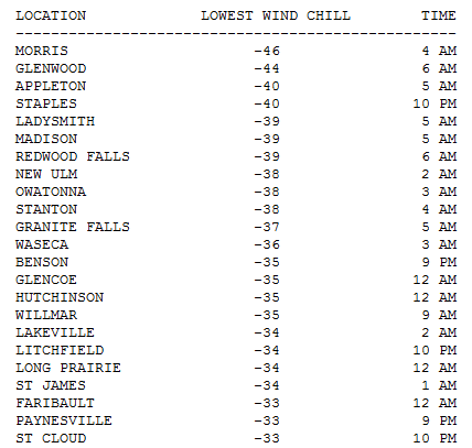
Glad That's Over. Here is a short list of some of the Friday morning windchills around the state, as low as -46 F. at Morris. In the Twin Cities the wind chill dipped to -28 at midnight. More facts and figures from NOAA
here.
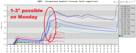 Monday Snow Event?
 Latest models are pretty unanimous printing out accumulating snow on Monday, roughly a tenth of an inch (liquid), which could translate into 2" of snow for the metro area.
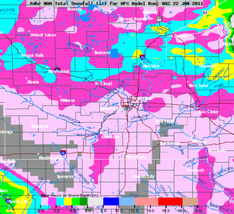 How Much
. The next clipper Sunday night and Monday has the best chance of dropping accumulating snow north of I-94, maybe a couple inches from St. Cloud into the far northern suburbs of the Twin Cities.
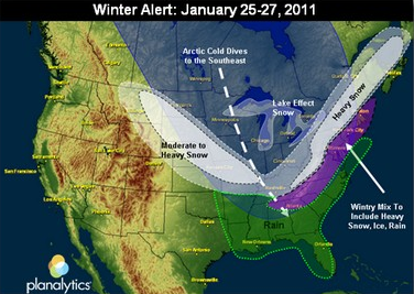
Primetime Wintertime. The meteorologists and weather analysts at Planalytics are tracking a major outbreak of bitter air, capable of spinning up a major coastal storm for the east coast next week. A summary of what may go down next week: "
As the Northeast clears the light to moderate snowfall from today, cold Arctic air will encompass much of the Eastern half of North America through the weekend into next week. The recent stormy pattern has been constant through the month and is expected to continue. Moving through next week, virtually all of the Upper Midwest and Northeast should prepare for below normal temperatures. Most locations east of the Rockies can expect temperatures to trend 15 to 30°F colder than normal and last year. For many, the extreme cold will represent the coldest air of the season. This Arctic outbreak will drive demand for auto batteries and help clear remaining inventory of need-based cold weather items such as heaters, electric blankets, outerwear, boots, hats and gloves. Consumables such as soup and hot cereal will also be in high demand. Conversely, temperatures in the West will trend normal to slightly above normal. In addition to the frigid temperatures in the East, weather models are showing the potential for a traffic-limiting event early to mid-next week along the Southern Tier, and the possibility of yet more snow in the Mid-Atlantic and Northeast regions."
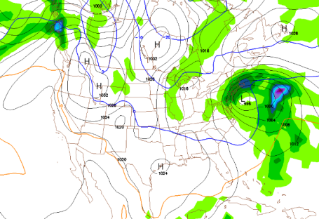
Another Major East Coast Storm Next Week? The GFS model, valid next Wednesday at 1 pm, shows a major storm winding up off the coast of New Jersey - probably cold enough for all-snow from Washington D.C. and New York to Boston. If you're traveling east next week you'll want to check back in for the latest updates.
Cold Comfort: Canada's Record-Smashing Warmth. This will come as small consolation - but the cold air that SHOULD be over central and eastern Canada has been pushed farther south (that whole negative phase of the NAO, North American Oscillation, that I wrote about a few days back). Unusually warm high pressure over the Arctic pushing the polar vortex, the swirls of bitterly cold air rippling around the Northern Hemisphere, farther south, with more frequent intrusions into the Lower 48, spinning up not only harsher cold fronts but more numerous (and intense) storms. From an NCAR
blog written by Bob Henson: "
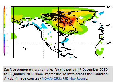
Some fascinating weather has unfolded across the Northern Hemisphere over the last month, but you may have only heard about part of it. The media dutifully reported on the heavy snow that battered the mid-Atlantic and New England states in late December. It was also the United Kingdom’s coldest December in at least the last century. Meanwhile, the sparsely populated Canadian Arctic basked in near-unprecedented mildness.
It’s the second chapter of a tale that began a year ago, when Canada as a whole saw the warmest and driest winter in its history. Much of the blame went to El Niño, which typically produces warmer-than-average weather across Canada. So far, so good—but similar things are happening this winter, even with a La Niña now at the helm. Just how mild has it been? The map at right shows departures from average surface temperatures for the period from 17 December 2010 to 15 January 2011, as calculated by NOAA’s Earth Systems Research Laboratory. The blue blip along the southeast U.S. coast indicates readings between 3°C and 6°C (5.4–10.8°F) below average for the 30-day period as a whole. That’s noteworthy—and in fact, it was the coldest December in more than a century of record-keeping across south Florida (see PDF summary). Blue also shows up across the UK, where December averaged 5.2°C (9.4°F) below normal."
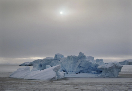
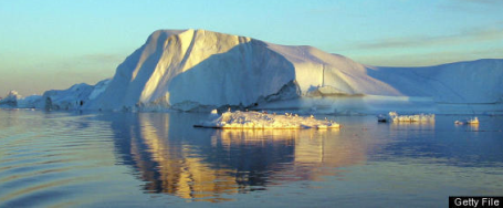
Melting Of Greenland Ice Sheet Set New Record In 2010. The International Business Times has an
update on the rate of change taking place in Greenland: "
Melting of Greenland ice sheet set new record in 2010, as some areas in the second largest ice body in the world experienced melting for longer duration last year, says a research conducted by the World Wide Fund for Nature (WWF) and City College of New York. "This past melt season was exceptional, with melting in some areas stretching up to 50 days longer than average,” said Dr. Marco Tedesco, Director, Cryosphere Processes Laboratory, City College of New York. “Melting in 2010 started exceptionally early at the end of April and ended quite late in mid- September,” said Dr Tedesco. Covering 80 percent of the surface of Greenland country, the ice sheet is prone to effects of global warming. Melting of this ice sheet is expected to significantly rise the sea levels in the coming decades."
 Weather Talk Update from Mark Seeley
. Here is an excerpt from Professor Mark Seeley's excellent
Weather Talk blog, which comes out Friday of every week - which always include some great nuggets of information. "
Many observers also report 15, 16, even 17 days with snowfall so far this month. Through Friday, January 21st, in the daily national weather summary the coldest temperature in the 48 contiguous states has come from Minnesota eleven times Babbit, MN has been below 0 F every night but two this month, and has reported -29 degrees F or colder on six mornings. On Tuesday, January 18 this week Flag Island on the ice covered Lake of the Woods never got warmer than -9 degrees F. On Friday, January 21st the coldest readings of the winter were recorded at nearly all locations across the state. Up north, Ash Lake and Big Fork reported -42 degrees F, Park Rapids and Waskish reported -40 degrees F, and International Falls reported -46 degrees F (coldest in the nation), coldest temperature measured there since 1968."
St. Louis Dumping. Close to a foot of snow fell on St. Louis, the core of the jet stream, the main highway for storms, supressed 300-500 miles south of Minnesota. Gawk at the You Tube footage
here.
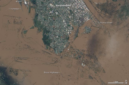
2011 - Year Of The Flood. The airport, the Bruce Highway, and large swaths of Rockhampton, Australia, went under water due to flooding from the Fitzroy River on January 9, 2011. The town of 75,000 was completely cut off by road and rail, and food, water and medicine had to be brought in by boat and helicopter. Image credit: NASA. Jeff Masters at
Wunderblog has an excellent recap of the (extreme) floods observed worldwide in recent months. No, you're not imagining it - the frequency (and intensity) of flooding has spiked recently, symptomatic of a warmer (wetter) atmosphere, a preview of coming attractions. Already in 2011 Brazil, Australia, Sri Lanka, the Philippines and South Africa have been overwhelmed by record floods, in some cases 1-in-100 year inundations. Masters writes: "
The year 2010 was one the worst years in world history for high-impact floods. But just three weeks into the new year, 2011 has already had an entire year's worth of mega-floods. I'll recap here six remarkable floods that have already occurred this year."
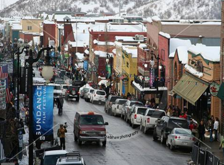
Sundance. I've only ever been to Park City, Utah once for Sundance, but it was an amazing couple of days. If you ever get the opportunity to attend - go for it. You get to see scores of movies, bump into a few movies stars, enjoy the ambiance of this (authentic) silver mining town. From Tina Early: "
Sundance has arrived! Main Street is a hubbub of activity. Lights, cameras and most important, action. There are lots of interesting characters walking around. The Festival itself would make a great documentary. "What It Takes To Get A Film Sold". I think it's the most entertaining of Park City's festivals. Luckily the weather spectacular...the skies are deep blue and the temperature is perfect for cruising Main Street."
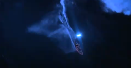
Taming "Jaws" (At Night). I have never seen anything like this
You Tube clip. This takes extreme surfing to new levels. At night. 40 foot waves. More details: "
Pro surfer Mark Visser wore a LED-covered vest and surfboard while riding 30-40 foot waves off Hawaii. The visual effect was stunning, as well as difficult to capture on film.
Engineered LED lights were built into a bupuancy vest and modified into the surfboard. The lighting technologies were created especially for the project by Solus Corporation using ground breaking NASA submarine lighting to ensure the wave and board were lit in the right places, at the right time and illuminated the wave without hindering the vision of Visser, the jet ski drivers and the helicopter pilots."
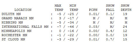 Coldest Day of Winter?
 We'll see - another Arctic front is shaping up for the first week of February - not sure it will be quite this cold, but we are by no means out of the woods just yet. Friday highs ranged from -7 at International Falls (up from -46) to -3 at St. Cloud to 0 in the Twin Cities. Snowfall ranged from 1/10th of an inch at Duluth to .7" at St. Cloud, just under a half inch in the Twin Cities.
 Paul's Conservation Minnesota Outlook for the Twin Cities and all of Minnesota:
TODAY: More clouds than sun, still nippy. Winds: N 5-10. High: 6
SATURDAY NIGHT: Partly cloudy, still bitter. Low: -8
SUNDAY: Mostly cloudy. Light snow develops at night, an inch or two possible by Monday. High: 12
MONDAY: Light snow tapers to flurries, icy AM commute? High: 19
TUESDAY: Intervals of sun, feeling better. Low: 11. High: 26
WEDNESDAY: Lot's of clouds, still storm-free. Low: 14. High: 24
THURSDAY: Patchy clouds, "above average" (finally). Low: 9 High: 25
FRIDAY: Mild start, then turning colder, flurries possible. High: 29 (early)
Age of Miracles
In the turmoil surrounding the Arizona shooting one statement really jumped out of the horrifying headlines. "We're wise to acknowledge miracles." Congresswoman Gifford's rapid recovery is nothing short of miraculous, an inspiration to everyone following her story.
But minor miracles are a daily fact of life for the rest of us, too. Anyone who has ever been in a delivery room, or watched as doctors healed their kids, is a true believer. My oldest son is alive today because of amazing Minnesota doctors. The older I get - the less I take for granted.
"Every gardener knows that under the cloak of winter lies a miracle," said Barbara Winkler. Yes it's cold, but a little perspective is in order. We've seen 7 subzero nights; last year we had already endured 13 nights below 0. A typical winter brings nearly 30 subzero nights. Based on heating degree data we've spent 5% LESS money than normal, to date, heating our homes.
Remember, the previous 6 winters averaged only 39" snow. Yep, we've been spoiled. Next week brings another major snow/ice storm for the east coast, while we enjoy 20s, even a (slight) shot at 30 F by Friday. That, in and of itself, would be a minor miracle right about now.
Greenland's "Early" Sunrise - Link To Climate Change? This one is a real head-scratcher, not sure how warming of Greenland in recent years might have an astronomical link, and create the illusion (?) of an earlier sunrise. Some astronomers believe warmer air over Greenland may be impacting refraction of the sun's rays - I don't pretend to know, but here's a
post attempting to explain the observed changes: "
The latest thing going around the internet today is that the Sun rose on in a small burg called Ilulissat in Greenland on January 11th. Ilulissat is north of the arctic circle so it experiences 24 hours of darkness for several weeks. Nothing unusual there. The unusual part is that the Sun usually rises again on January 13th. Therefore, the Sun came back two days early and the question is why. The first thing to do is to verify the claims is true. I checked out the NOAA Sunrise/Sunset calculator (after finding what I think is the lat/long of Ilulissat. There are lots of places with similar names in Greenland!) and the US Naval Observatory. Sure enough, January 12th, no sunrise. January 13th, there is a sunrise and a very short day. Okay, NOAA and USNO agree with the prediction and they are pretty reputable in such matters. The next thing is to verify the observation. This part is much trickier. The story has gone viral on the web. The best I can tell, it started with a story in the Daily Mail. Read it and you can see the details of who made the observations and where are pretty sketchy…okay, non-existant. No mention of the time of the observation, how long the Sun stayed up, location of observation, azimuth of the Sun (I don’t consider the stock photo they used in the story to have any bearing on anything) or who made the observation. A photo of the sunrise with an identifiable landmark would have been REALLY useful!"
* Another link from Huffington Post about the "early sunrise" over Greenland is
here.
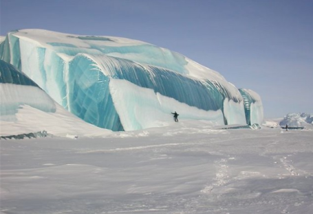
Frozen Tsunami Waves Dound In Antarctica. Now this is a wild sight! From an
article at nowpublic.com: "
The annual mean temperature of Antarctica is below 0c (freezing temperature of fresh water). Salt water has a lower freezing point, depending on the concentration. Antarctica is by far the coldest continent and some places reach -90c. Here are some pics of a frozen tsunami wave, which are caused by earthquakes."
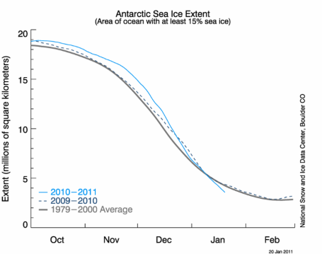
Antarctic Sea Ice Loss. While we shiver much of Canada, Greenland and Siberia is experiencing unusual warmth (no, it's not this cold across all northern latitudes). Ice loss at Antarctica has been noteworthy as well. Climate scientist Lou Grinzo Grinzo has created a great
web site, focused on what's happening in the Arctic, Greenland and Antarctica.
 Troubling Trends
. Arctic sea-ice cover in December 2010 was the lowest on record, with an average monthly extent of 12 million square kilometres, 1.35 million square kilometres below the 1979-2000 average for December. This followed the third-lowest minimum ice extent recorded in September. Souce: NOAA.
Does Helping The Planet Hurt The Poor? See if you can follow the logic of
this editorial in the Wall Street Journal, written by Bjorn Lomborg. An excerpt: "
Peter Singer poses an interesting and important question: Can we afford to both reduce poverty and clean up the environment? From an empirical standpoint, the answer is definitely yes. The developed world is sufficiently rich that doing both should be well within our means."

No comments:
Post a Comment