* Winter Storm Watch posted - will probably be upgraded to a warning sometime today by the National Weather Service.
* Get your errands done today, if possible. You won't want to spend much time on the highways tomorrow into Monday morning.
* Snow begins late tonight - heaviest snows should fall between midday Sunday and Sunday evening, at the rate of 1" an hour at times. Think twice about travel after noon tomorrow - the worst conditions will probably come Sunday evening and Sunday night, as wet/slushy roads turn to ice.
* Air temperatures should be in the mid-upper 20s at the height of the storm, creating a very wet, slushy snow - but it should still be cold enough for blowing and drifting (which will be worse the farther north/west you travel, away from the metro Sunday and Sunday night).
* Winds will be in the 20-30 mph range - not blizzard criteria, but close. I expect travel conditions to get progressively worse during the day tomorrow.
* The atmosphere should be cold enough for all-snow in the Twin Cities, St. Cloud and Willmar. Ice (sleet and freezing rain) may mix in over far southern Minnesota, near Albert Lea, Fairmont and Winona, keeping snow amounts down.
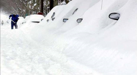
* How much? If the current models hold (and there has been a fair amount of consistency in the last 3 model runs) the Twin Cities metro could be looking at 7-12", with the heaviest amounts over the north metro.
* Parts of central and west central Minnesota may be digging out from 15-20" by late Sunday night.
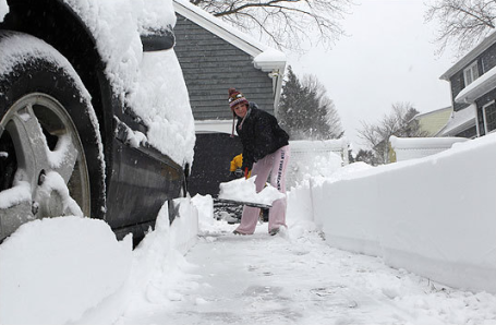
* Snow tapers to flurries during the day Monday as travel conditions gradually improve on area highways. That said, I still expect a VERY slow rush hour Monday morning.
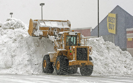
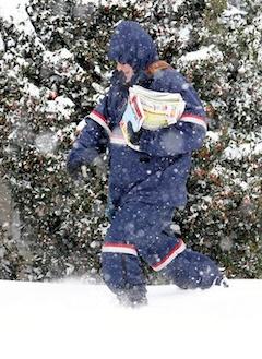
Snowmageddon!! Snowpocalypse!! O.K. Not really, but it will snow pretty hard tomorrow. Never tell a Minnesotan not to drive. It's our God-given right....right? Just a friendly word of advice: get out to Best Buy (or Rainbow) today, because conditions will be pretty bad tomorrow. Not exactly a blizzard but low visibility, strong, sustained winds capable of blowing and drifting, and snow falling at the rate of 1"/hour by afternoon and evening. Conditions slowly improve on Monday. Snow day? Possibly. But don't count on it. Get your homework done, just in case.
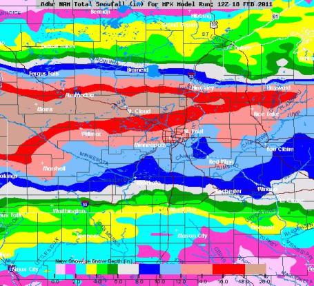
A Very Significant Pile. The latest NAM model prints out the heaviest snow bands from Alexandria and St. Cloud into the northern suburbs of the Twin Cities, where some 12-16" amounts are expected. The metro could still wind up with a cool foot, if everything goes just right (or wrong, depending on your opinion of snow). I think 7-11" is fairly conservative, believe it or not, and I've found (the hard way, over time) it pays to be conservative. What can possibly go wrong?
Second Biggest Snowfall of Winter? It's beginning to look that way. The latest NAM prints out nearly 20" for parts of southwest and west central Minnesota, with over a foot across much of central Minnesota, including St. Cloud. Amounts drop off farther south, as you head toward Mankato (6-8") and Rochester (8"+), but the metro could pick up as much as 10, even 12" of snow from this slow-moving Sunday storm.
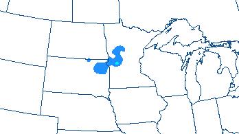
Winter Storm Watch. Check out the size of the area impacted by a Winter Storm Watch, in effect from late Saturday night through 6 am Monday morning. A watch means "watch out", conditions are ripe for 6" or more of snow in a 24 hour period, possibly mixed with ice over far southern Minnesota. If the track remains (on-track) I expect these watches to be upgraded to Winter Storm Warnings during the day Saturday, which means heavy snow is imminent.
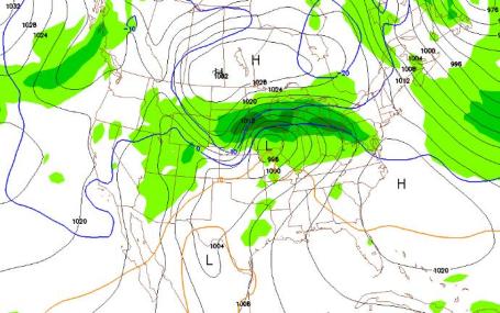
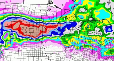
A Textbook Snowstorm. This (NAM) model prediction is valid for 7 pm Sunday, showing accumulated precipitation for the previous 6 hours, from 1 pm to 7 pm. The darker green-shaded areas depict heavier snow, with the main snow band setting up from the central Dakotas into central Minnesota and the north metro, the storm centered just south of Des Moines - tracking due east, toward Rockford and Chicago.
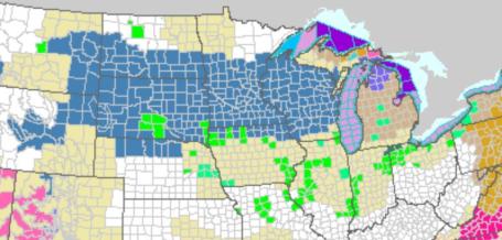
Blizzard Potential. An experimental NOAA product shows a significant probability of blizzard criteria (sustained winds of 35 mph, visibilities under 1/4 mile in falling/blowing snow) over parts of west central Minnesota. This map is valid 1 pm tomorrow.
A Prime Track For Heavy Snow. It doesn't get too much better than this (for snow-lovers). A slow-moving storm, capable of tapping moisture from the Gulf of Mexico. A track across central Iowa toward Chicago, keeping any changeover to ice/rain well south of the area. Not sure how we don't get at least a half foot out of this. But the models have been fairly consistent printing out close to 1" liquid for the metro, which (using a 10/1 snow/rain ratio) equates to about 10" of heavy, wet, slushy snow.
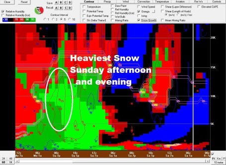
Cross-Section Of A Major Snowstorm. The "Bufkit" guidance from NOAA shows the heaviest burst of snow coming Sunday afternoon into the evening hours (when upward motion overhead will be most intense, whipping up the heaviest snow amounts). The temperature profile will be ripe for "dendritic crystal growth", increasing the potential for a foot of snow close to home.
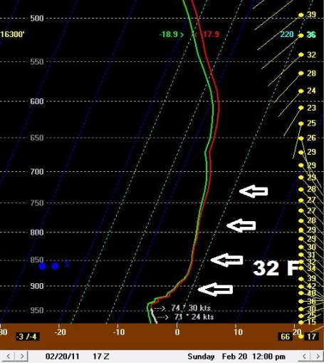
Cold Enough For Snow. The predicted temperature "sounding" at noon tomorrow shows temperatures throughout the lowest mile of the atmosphere (from the surface to roughly 800 mb) below freezing, meaning snow. Over far southern Minnesota a thin layer of air warmer than 32 F. may produce a mixed bag of snow, sleet and freezing rain, keeping snowfall totals down.
100 Degrees In One Week? Here in Minnesota we experienced a 60-80 degree temperature swing from the previous week to this past week. But Yahoo News reports on one Oklahoma town boasting a 100 degree swing: "Residents in the Northern Oklahoma town of Nowata experienced a nearly 110-degree shift in the weather this week after a cold front brought temperatures down to a record-setting -31 degrees. Today, it's a balmy 72 degrees in Nowata. Yesterday, it reached 79 degrees. "Isn't it crazy? I love it," Nowata resident Julie Koupe told local channel News on 6. On Feb. 10, it was slightly colder in the region than it was on the South Pole, notes Tulsa World writer Cary Aspinall. More than 3,000 Nowata homes lost power and residents spent the next few days digging their cars and homes out of the snow. There was so much snow in Tulsa last week that city officials began debating provisional plans to truck it out of town. On Thursday, the 79 degree weather tied for the warmest Feb. 17 since 1907."

Crocodile Warnings In Effect. No, we're not making this up. Accu Weather reports on the recent cyclone (hurricane) which brought out the crocodiles. Kind of puts things into perspective: "Residents across Australia's Top End remain on alert for crocodiles roaming waterways left flooded in the wake of once-Tropical Cyclone Carlos, which could soon regain strength. Officials are concerned that swollen waterways will allow crocodiles to reach locations outside their normal habitats, according to the Northern Territory News. The waterways across Australia's Top End are still flooded following the recent inundation of torrential rain from Carlos. Carlos "left a four-day rainfall total of 673 mm, or 26.5 inches, at the Darwin airport," reports AccuWeather.com International Expert Meteorologist Jim Andrews. The city only averages 365.6 mm, or 14.39 inches, during the entire month of February.
Paul's Conservation Minnesota Outlook for the Twin Cities and all of Minnesota:
TODAY: Clouds increase, good travel day. Winds: E 10. High: near 30
SATURDAY NIGHT: Dry evening, but light snow arrives late Saturday night. Low: 25
SUNDAY: Storm watch. Heavy, wet snow, 7-12" possible. Travel becomes treacherous. Winds: Northeast 15-30. High: 28
MONDAY: Very slow AM rush hour. Snow gradually tapers to flurries by evening, another 1-2" in the morning. High: 23
TUESDAY: Sun returns, cool breeze with better travel statewide. Low: 5. High: 25
WEDNESDAY: More clouds, passing flurries - little or no accumulation. High: 33
THURSDAY: Sunny start, clouds increase. High: 32
FRIDAY: More accumulating snow possible. High: 29
The Big Dump
Meteorologists get a little nervous when it gets too nice, too fast. Wednesday's 52 felt great, but the atmosphere has an uncanny ability to "even things out". Unusually nice weather is usually followed by a foul spell.
If the models are right and the storm stays on-track, we could see over a cool half foot Sunday; a few towns could over the north metro could dig out from 8-12", with well over a foot close to St. Cloud, Brainerd, Bemidji and Duluth. The lowest mile of the atmosphere should be cold enough for all-snow but far southern Minnesota may see a period of significant ice. Bottom line: get your errands out of the way tomorrow. Sunday may not be the best travel day.
Remember when you were a kid, when storms held the promise of snow-days, snowmen and fun with the neighbor kids? Somehow we've lost that sense of magic over the year. We spend our time fixating on weather for our (tortured) commutes. Now it's a "threat of snow", a "risk of a storm". It's all gloom and doom.
All I know is this week's extended thaw was a treat. And now kids (of all ages) get a cold, crystalline gift from on high. Perfect weather to PLAY in the snow. And look at the bright side: it's coming on a Sunday.

Looking For A Speaker? I have 3 talks coming up in March - looking forward to talking about climate change in Minnesota and my entreprenurial adventures (and disasters). I have a multimedia presentation, all I need is a black cup of coffee (and good directions to your company). If you want to help me raise some money for the Paul Douglas Foundation click here.
No comments:
Post a Comment