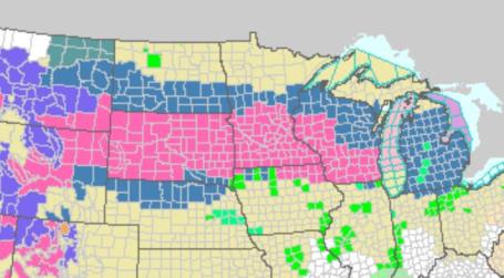
* 18z run shifts the very heaviest snow band just south of MSP, but it's still too close to call where that heavy band will set up.
Winter Storm Warnings are posted for Sunday into early Monday, try and get your travel plans and errands out of the way today, if at all possible. I still think travel conditions will go from very poor (morning hours Sunday) to treacherous (by Sunday afternoon/evening).
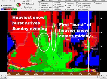
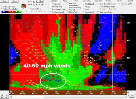
The heaviest snows come from midday Sunday into early Sunday night, when snow may be falling at the rate of 1-2"/hour. Sustained winds will reach 25-35 mph Sunday afternoon/night, close to blizzard criteria.
I say this with all humility and respect, but travel isn't recommended after midday tomorrow. The very worst travel conditions will probably be Sunday evening/night.
Cold enough for all snow - a little ice is possible near the Iowa border.
Another 1-2" may fall early Monday morning, but the brunt of the accumulation comes Sunday and Sunday night.
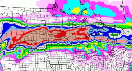
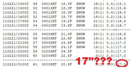
Latest Guidance. The intermediate 18z NAM run keeps the very heaviest snow band just south of MSP, with closer to 8-12" for much of the metro, and as much as 15-20" for Mankato and Rochester. We'll see if this is a fluke or a real trend in the models. Not sure how we see anything less than 6-8", but the best chance of a foot more more may be over the southern suburbs.
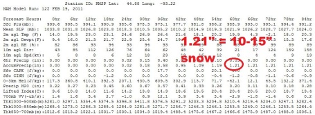
Midday Saturday Update From the National Weather Service (fairly technical, but I thought the die-hard weather freaks....and I say that with all love and devotion....might want to see this):
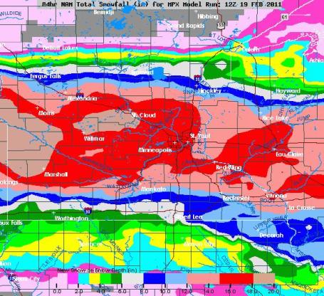
FOCUS TURNS TO NEXT SNOWSTORM FOR THE AREA. WATER VAPOR IMAGERY
SHOWING STRONG TROUGH LIFTING NORTHEAST ACROSS THE SOUTHWEST US.
BLENDED PERCENT OF NORMAL PRECIPITABLE WATER SATELLITE PRODUCT
SHOWS LARGE AREA OF OVER 200% OF NORMAL PRECIPITABLE WATER VALUES
MOVING ACROSS THE SOUTHWEST US. THIS SOURCE REGION THEN LIFTS
NORTHEAST AS THE NEGATIVELY TITLED TROUGH LIFTS NORTHEAST AND
GENERATE CYCLOGENESIS OVER EASTERN COLORADO LATER TONIGHT. THIS
WILL SPREAD THICKER CLOUDS INTO THE SOUTHWEST THIS EVENING AND
DEVELOP THE THREAT OF SOME LIGHT SNOW THERE BEFORE MIDNIGHT.
STRONG WARM SURGE...ESPECIALLY AT MID LEVELS LIFTS NORTHEAST AHEAD
OF THE SURFACE LOW WHICH MOVES ACROSS KANSAS TO IOWA BY SUNDAY
EVENING. STRONG FORCING ASSOCIATED WITH COUPLED H25 JET MOVING
THROUGH THE AREA SHOULD GENERATE STRONG FORCING FOR SOME HEAVY
SNOW. BOTH NAM AND ND GFS INDICATE HEAVIER SNOW BAND TO DEVELOP ALONG
AND NORTH OF THE MN RIVER VALLEY...AFFECTING MUCH OF CENTRAL MN
INCLUDING THE TWIN CITIES. CURSORY LOOK AT POTENTIAL HIGH SNOW
AMOUNTS VIA BJ COOKE TECHNIQUE INDITES AROUND 14 INCHES POSSIBLE.
THIS MATCHES PRETTY WELL WITH THE BUFKIT/CARIBOU SNOW
ACCUMULATIONS...ESPECIALLY OVER CENTRAL MN. THIS LEAVE A LARGE
AREA OVER OVER 10 INCHES ACROSS CENTRAL MINNESOTA INTO WEST
CENTRAL WI...WITH 13-15 INCH AMOUNTS POSSIBLE IN THE HEAVY SNOW
BAND. THIS BAND DEVELOPS OVER OVER THE METRO SUNDAY MORNING PER
GFS FRONTOGENESIS BAND AND MINUS 15C OMEGA FIELD. IT DEVELOPS OVER
CENTRAL MN AND PIVOTS ONLY SLOWLY TO THE EAST DURING THE DAY. THIS
SHOULD YIELD AT LEAST 1 INCH AN HOURS SNOWFALL RATES UNDER THIS
STRONGLY FORCED LIFT ZONE.

No comments:
Post a Comment