* Colder air returns today on gusty northwest winds (reaching 30-35 mph. at times).
* Saturday: drier day of the weekend, better day for travel plans and errands.
* Potential for ice Saturday night; light freezing rain/drizzle can't be ruled out.
* Accumulating snow likely Sunday, heavy, wet, slushy snow.
* Potential for 2-4" metro, with greater amounts north. As much as 5-10" or more may fall from near Brainerd to Grand Rapids and Duluth.
* Sunday temperatures should be close to freezing, helping to keep many major roads wet/slushy, but snow-covered roads are possible across much of central and northern Minnesota.
* Snow tapers Sunday night - roads should be in fairly good shape for Monday commutes.
* Another chance of mixed precipitation (ice, rain and wet snow - in that order) next Wednesday.
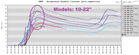
2-14", Give Or Take. Deep breaths. No, I don't think we'll wind up with 14" of snow, at least not in the Twin Cities. Right now it appears the heaviest snow bands will set up over central and northern Minnesota, with lesser amounts in the metro area. I'm inclined to go with the NAM solutions, which are all clustering around 2-4" on Sunday, which I think is a reasonable forecast for Sunday's snow event.
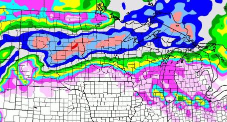
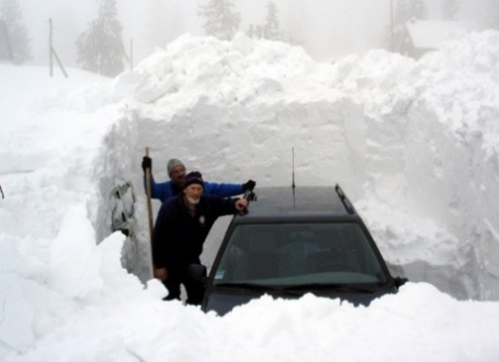
Slushy, Snowy Sunday? The "NAM" model continues to print out .5 to .6" liquid from late Saturday night into Sunday evening, the lowest mile of the atmosphere (probably) just cold enough for mostly-snow at the height of the storm during the morning/midday hours Sunday. 2-4" of slushy snow may fall, with some 5"+ snowfall totals possible north metro. Farther north, closer to Brainerd, amounts could exceed 8-10" or more. Again, a slight shift in the storm track will make a huge difference in snow totals, but it still looks "plowable" for much of Minnesota (with the exception of far southern Minnesota).
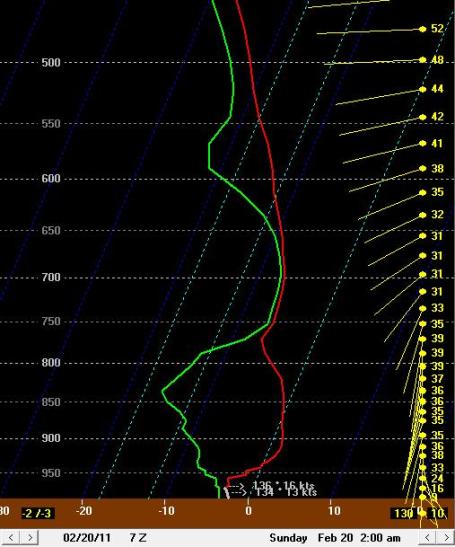
Freezing Rain Potential. The temperature "sounding", a vertical slice of the atmosphere - shows enough warm air surging northward some 2,000 - 3,500 feet above the ground for a period of rain/drizzle Saturday night. Surface temperatures may be in the upper 20s, meaning a potential for "freezing rain" or glaze ice. If you're out late Saturday night, beware of ice.
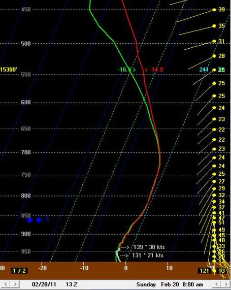
Sunday Snow Event. By 8 am Sunday the entire column of the atmosphere over the Twin Cities is forecast to cool, the lowest mile of the atmosphere colder than 32 F, meaning a changeover back to (wet) snow. Expect strong winds to accompany the snow. Temperatures here on the ground may be close to 32 F, possibly climbing into the mid 30s, helping to keep major roads wet/slushy, much different from a January storm with temperatures in the teens. That said, it may still be a sloppy, slushy mess out there for a time Sunday.
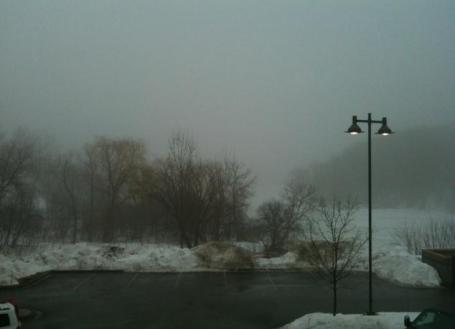
Murky Friday. Low clouds, fog and drizzle (.01" rain fell) kept temperatures cooler than they would have otherwise been yesterday, highs in the mid 40s in the metro, still 15 degrees above average for February 17. Thanks to WeatherNation meteorologist Bay Scroggins for snapping this photo.
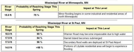
Updated Spring Flood Outlook. A 94% risk that Harriet Island in St. Paul will be submerged? A 75% probability of flooding of industrial and residential areas of North Minneapolis? The Chanhassen office of the National Weather Service issued an update on the spring flood situation Friday, a heightened risk overall (although this week's premature thaw may still take the edge off some of the risk). There are too many factors which are simply unknowable at this point: how much additional snow will fall, how quickly we'll warm in the coming weeks, whether warm fronts will be accompanied by heavy/steady rain, which would accelerate snow melt. Click here to see details for specific towns across the state: "February 17,2011... The National Weather Service has issued an updated spring flood outlook for locations across the upper midwest. Above normal rainfall early in the fall, combined with snowfall that was above normal for the period from November through mid-February, has led to the potential for significant flooding along many rivers in Minnesota and western Wisconsin. The text of the Spring Flood Outlook details a probabilistic forecast, showing percent chances of reaching critical stages at various forecast points along area rivers. There are several factors that will go into determining the eventual river crests this spring at these locations. These factors include the amount of precipitation that falls over the area this spring, how fast the temperatures warm up during the coming months, and any ice jams that may form along the rivers. The next spring flood outlook will be issued on March 3rd. As the rivers rise this spring, detailed information about river levels and crest forecasts can be found on our Advanced Hydrologic Prediction Service page."
Bill Before Congress Would Slash Budget For National Weather Service. I realize everyone has to tighten their belt; I understand as well as anyone else that our nation's deficit has reached a crisis stage. But forcing the National Weather Service to take a 30% cut, at a time when severe weather is on the increase? Seems pretty draconian and short-sighted to me. If this happens, just wait for the lawsuits that arise from the next missed tornado outbreak, or the next Category 3 hurricane that strikes the coast with insufficient warning. Launching weather balloons every other day? That's the most ridiculous thing I've ever heard. The USA is blessed with the best weather service of any nation on Earth, but if we're not careful we're going to gut the NWS - at a time when we all need it more than ever. Here are the details: "When the budget blade drops on the NWS, it will be felt around the country," said NWSEO President Dan Sobien. "In the next hurricane, flood, tornado or wildfire, lives will be lost and people will ask what went wrong. Congress's cuts and the devastation to the wellbeing of our nation's citizens are dangerously wrong." Reduced funding will mean upper air observations currently made twice a day might be reduced to every other day. Buoy and surface weather observations, the backbone of most of the weather and warning systems, may be temporarily or permanently discontinued. Delays in replacement satellites run the risk of losing key weather data that can be obtained no other way. "This information is vital for weather modeling and essential for accurate tornado watches and warnings," said Sobien. The National Hurricane Center is not immune to these cuts as furloughs and staffing cuts will add strain to the program. The Hurricane Hunter Jet, which provides lifesaving data and helps determine a hurricane's path, could also be eliminated."

"THON" Dance Marathon. As a father who experienced a potentially life-altering cancer scare with my own child, I can confirm that there is no scarier diagnosis for a parent. Last year students at Penn State, another Big 10 school, raised nearly $8 million, in spite of the recession. No "adult supervision" - the entire 48 hour weekend dance-a-thon is organized and run by students, including fraternities and sororities who "can" on city streets for months leading up to the event. More on the event from the THON web site: "Welcome to THON.org, the online home of the largest student-run philanthropy in the world! The Penn State IFC/Panhellenic Dance Marathon, affectionately referred to as THON, is a yearlong effort to raise funds and awareness for the fight against pediatric cancer. Since 1977, THON has raised more than $69 million for The Four Diamonds Fund at Penn State Hershey Children's Hospital."

Meet Xander Beltz. Xander is one of 2,000 kids who have been treated for various forms of childhood cancer, thanks to "THON", kids from all around the nation, including Minnesota. Here is his story: "I wanted to share our story and send along our gratitude - Xander was diagnosed @ 19 months with AML (Acute Myeloid Leukemia). Since then our world has been turned upside down. He's had 2 rounds of chemo since diagnosis, and has 4 more to go. We have heen staying at the RMH during treatments, which is such a blessing! We are so grateful to the Four Diamonds Fund, which has been so generous! Until all this happened, we didn't even know it existed. When I saw the students standing in the cold near the Childrens' Hospital in Hershey, with their cans that said "Help kids with cancer", I cried!!! It really hit me - my son has cancer, and these kids care so much about my son that they spend time in the freezing cold to collect donations to help him and kids just like him. My husband and daughter (our well child) dropped all the spare change we had into the can and shook the hands of those students who care so much. I can't express the deep appreciation I feel to you and your fellow students who make it your goal every single year to help families like mine."
More on Xander's story here.
This is a great cause - if you'd like to consider making a donation click here.
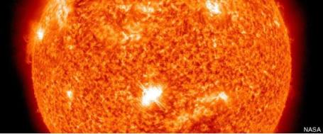
Immense Solar Flare To Cause Northern Lights Show, Interference With Communications. If skies clear you may want to check out the northern sky; activity is increasing on the sun, more sunspots and massive solar flares. Here's an excerpt of a story from Accu Weather: "The sun has been and continues to be extremely active, unleashing solar flares from a sunspot region that was barely visible last week. The sunspot has grown in size to more than 62,000 miles across, a width nearly eight times the width of our Earth. A video about the solar flare from AccuWeather.com Meteorologist Mary Yoon can be seen by clicking here. The first flare was categorized by the NOAA Space Weather Prediction Center in Colorado as a Class M6.6. Then on Monday, a more intense X2.2 occurred. This was the strongest flare reported in four years. These flares will ramp up the displays of northern lights for sky-watchers living in northern latitudes and lucky enough to have clear skies. Click here for a description of the classes of solar flares."
* More on the Aurora Borealis (northern lights), which may be visible tonight across much of the USA and Canada, from USA Today here.
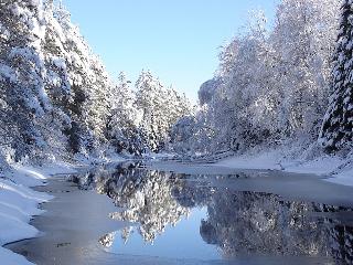
Marchlike Friday. In spite of dense fog and moderate to heavy drizzle at times (typical for mid March) the mercury still reached the mid 40s across much of Minnesota. Snow cover has shrunk to 6" at St. Cloud, only 2" of (nasty) snow in the Twin Cities, down from 11" as recently as last Sunday!
Paul's Conservation Minnesota Outlook for the Twin Cities and all of Minnesota:
TODAY: Blustery, colder with PM sun. Winds: W 15-30. High: 29 (wind chills in the teens and single digits).
FRIDAY NIGHT: Clear to partly cloudy (peek at the northern lights?) Low: 19
SATURDAY: Sunny start, clouds increase during the day - milder. High: 37
SATURDAY NIGHT: Mostly cloudy. Low: 26
SUNDAY: Potentially heavy wet snow. "Plowable amounts?" 2-4" slushy snow possible in the Twin Cities, more north of MSP. High: 33
MONDAY: Slushy start, slow clearing. High: 32
TUESDAY: Plenty of sun, better travel. High: 35
WEDNESDAY: A little ice? Light mix possible. High: 33
THURSDAY: Scrappy clouds, cool breeze. High: 32
Sunday Pay-Back?
We suffer for our springs. But yes, it was a very good week to be a meteorologist. People are smiling again, waving with all their fingers. "Paul, I can look at your 7-Day without holding my breath and closing one eye!" Lovely.
We haven't seen 50s in February since 2005. Somehow we skipped a month, with a balmy breeze more typical of April. And no, it wasn't global warming. It was "weather", a subtle (yet blunt) reminder that only Siberia sees more weather extremes. This hope-inspiring warm front has set us up for a fall. "We'll pay for this, won't we?" Yep. It was spring's first kiss, but before we get to the alter of daffodils and docks we'll have to endure a few more weather trials, sloppy snows, perilous potholes, mud-fronts, and a volatile flood outlook.A colder wind kicks in today, no travel problems Saturday. The potential for wet, slushy snow Sunday continues to rise. Parts of central and northern Minnesota could wind up with 5-10", probably less in the metro, but still enough to shovel & plow, maybe 3-4"+.
Winter's coldest weather is behind us now. Hey, a Minnesota spring is always 1 step forward, 2 steps back. We'll do the Slushy Shuffle for another 45 days or so. We'll get there.
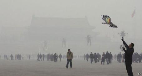
Climate Change In Black And White. The Economist tackles the potential perils of "black carbon", the carbon you don't hear quite as much about, but which poses a unique danger all it's own: "AN IDEAL fossil-fuel power-plant would produce power, carbon dioxide and nothing more. Less-than-ideal ones—not to mention other devices for the combustion of carbon, from diesel generators to brick kilns and stoves burning dung—also emit various gases and gunk. These often cause local environmental problems, damaging lungs, hurting crops and shortening lives. And some of the gunk, notably soot or “black carbon”, can warm the planet, too. Next week ministers attending the governing council of the United Nations Environment Programme (UNEP) in Nairobi will be presented with the summary of a new report on how fighting air pollution can help the global climate (the report itself is due to follow a couple of months later). The summary makes a powerful case for acting on two short-lived climate “forcings”, factors that change the amount of energy the atmosphere absorbs, as carbon dioxide does, but stay in it only briefly. One is black carbon and the other is ozone, which is vital for blocking ultraviolet rays in the stratosphere but hazardous in the bits of the atmosphere where plants live and people have to breathe."
Want To Fight Global Warming? Don't Just Focus On CO2. Science magazine looks at black carbon and methane in this article: "WASHINGTON, D.C.—Carbon dioxide is the elephant in the room for any discussion of how to stem global warming. But a new report suggests that tackling emissions of two other short-lasting pollutants—methane and the black component of soot—could slow expected warming by a full 0.5˚C beyond what targeting CO2 alone could accomplish by 2070. The report, which will be discussed here Sunday at the annual meeting of the American Association for the Advancement of Science (which publishes ScienceNOW), includes a lot of uncertainty. But it fits with what scientists have learned about these pollutants in recent years. Methane is a more potent warming agent than CO2, although its duration in the atmosphere is measured in decades rather than centuries. Methane also contributes to asthma-causing pollution. Black carbon, the product of burning wood or other carbon-based fuels, heats the air directly, accelerates the melting of any snow it lands on, and creates so-called brown clouds that warm the sky. Although harmful to the hundreds of millions who breathe it each day, black carbon settles out of the atmosphere in a few weeks. So reducing emissions of it would have a nearly immediate impact on global temperatures."
No comments:
Post a Comment