52 F. normal high for April 7 at MSP.
34 F. high on February 16, 2010.
29 F. normal high for February 16.
55 F. today's record high (1981).
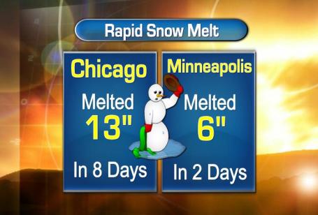
89. Number of days with at least an inch of snow since the snow season began on November 13, 2010.
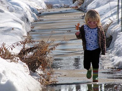
Headlines: 52 F. yesterday, today may be a couple degrees warmer, close to the all-time modern-day record of 55. Rapid snow melt will create dense fog, drizzle, but even with a sloppy sky we should still top 50. Pretty impressive for mid February. We cool down 20 degrees tomorrow on gusty winds (which may be in the 25-40 mph range). Saturday looks dry with good travel weather statewide, but a southern storm stands a good chance of turning on a potentially significant period of heavy, wet snow from Sunday afternoon into midday Monday. The timing and amounts are still tenuous - but there's certainly a potential for a significant "plowable" snowfall, with heaviest amounts south metro. Parts of southern Minnesota could wind up with over a half foot of snow, maybe a few 10" amounts near Rochester and Mankato if the models are on the right track. We'll see - if you're traveling late in the weekend or Monday you'll want to stay up on the latest forecast. No question next week will be stormier: a second storm arrives next Wednesday - if precipitation streaks in early it may start as a little ice before changing to rain, then ending as wet snow. Bottom line: make the most of today's taste of spring.
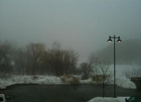
Fog Advisory. Significant snow melt has moistened up the lowest 1,000 - 2,000 feet of the atmosphere, increasing the potential for lazy clouds (fog) and drizzle. Details from the National Weather Service: A DENSE FOG ADVISORY HAS BEEN ISSUED FOR THE AREA LOCATED EAST AND SOUTH OF A LINE FROM REDWOOD FALLS...WILLMAR...TO ANOKA...AND EAST INTO WISCONSIN FROM NEW RICHMOND AND NEW AUBURN...FROM 9 PM THIS EVENING...CONTINUING THROUGH 9 AM THURSDAY. THE ADVISORY GOES INTO AFFECT FOR THE REMAINDER OF CENTRAL MINNESOTA AND WEST CENTRAL WISCONSIN AFTER MIDNIGHT. THE THICKER FOG IS EXPECTED TO MOVE INTO SOUTH CENTRAL AND MUCH OF CENTRAL MINNESOTA...AND WEST CENTRAL WISCONSIN THROUGH ABOUT 9 PM. VISIBILITIES WILL EVENTUALLYFALL TO 1/4 MILE OR LESS IN MANY LOCATIONS CREATING HAZARDOUS TRAVEL CONDITIONS. A COLD FRONT WILL SWEEP WEST TO EAST ACROSS THE REGION DURING THE LATE MORNING AND AFTERNOON...WITH IMPROVING VISIBILITIES BEHIND IT.
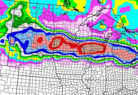
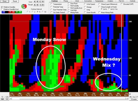
Storm Machine Returns Next Week. The latest GFS model (analyzed by the National Weather Service "Bufkit" tool) shows a significant potential for accumulating snow Sunday night into Monday, followed by a brief lull next Tuesday, before the next system arrives by Wednesday of next week, an icy mix changing to rain, then back to snow by Wednesday night. Timing and amounts for both storms are still very much up in the air.

Persistent Snow Cover. A blurb from the one and only Professor Bob Weisman, meteorology instructor extraordinaire up at St. Cloud State University (still the only school in Minnesota where you can pick up a 4 year meteorology degree), sharing what he hates about a central Minnesota winter: "...even though we've only had 3 days with measurable snowfall this month, one of the aggravatiing things about a northern and central Minnesota winter is our long period of consistent snow cover. We've now had at least an inch of snow on the ground ever day since November 23, which now makes 86 straight days of snow cover. That is now slightly above average for a cold season. According to the statistics I just finished compiling yesterday, St. Cloud normally has 86 straight days with at least an inch of snow on the ground each winter. Iin a typical winter, this starts around the 10th of December and ends about the 10th of March. Unfortunately, our snow season began about three weeks early this year. Unless we continue snow melting with the mild and dry weather, we are still likely to have another 3 weeks staring at this snow, pushing us over 100 straight days with a snow cover this year. However, we are not likely to break the longest streak with a snow cover, which was 146 days in 2000-2001. In that year, the snow cover didn't disappear until April 7." Ouch.
I asked Pete Boulay at the MN State Climatology Office for a snow update here in the metro area:
"The average number of days with an inch of snow on the ground is 100 days for the Twin Cities; including today we're at day 89. The first day with one inch of snow on the ground was November 13. The snow pack did go down to zero by Nov 22nd."
100 days/year with at least 1" or more of snow on the ground? Yes, we are a state brimming with Weather Warriors.

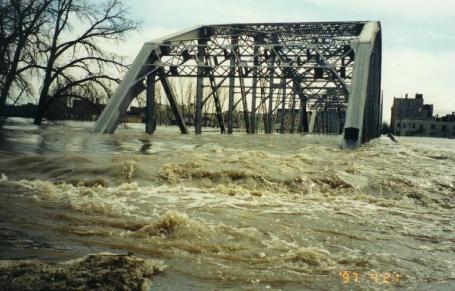
Watershed District Warn Of Spring Creek Flooding. I know we've melted a considerable amount of snow this week, but there's still at least 1-3" of water locked up in that remaining snow pack. A wet fall didn't help the overall flood situation - the extent of any future flooding will depend on how quickly we warm in March, and whether warm fronts are accompanied by heavy, steady rains, which would accelerate snow melt and worsen the flood potential. A story from Laurie Blake at the Star Tribune: "Watershed district officials overseeing Nine Mile Creek and Minnehaha Creek are advising cities and property owners along the two creeks and in low-lying areas around Lake Minnetonka that spring flooding is a strong possibility this year. Flood prediction is a new role for the watershed districts, prompted by December's record snowfall. "Usually the creeks are under everybody's radar. They worry about the rivers, and they worry about other things," said St. Louis Park Fire Chief Luke Stemmer. St. Louis Park, Edina, Minneapolis, Minnetonka and cities around Lake Minnetonka are all being briefed this year by Minnehaha Creek Watershed District on the potential for creek flooding."

Paul's Conservation Minnesota Outlook for the Twin Cities and all of Minnesota:
TODAY: Dense fog advisory. Near-record warmth, cloudy & foggy with drizzle possible. Winds: S 10-15. High: 52 (record is 55, set in 1981)
THURSDAY NIGHT: High winds, turning much colder. Low: 27 (winds gust to 30-40 mph).
FRIDAY: Gusty winds, noticeably colder with more clouds than sun. Winds: W 20-35. High: 32
SATURDAY: Drier day of the weekend, chilled sunlight. High: 36
SUNDAY: Clouds increase, wet snow developing by afternoon, becoming heavier Sunday night. High: 39
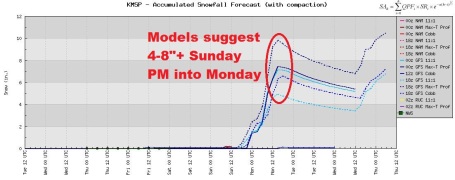
MONDAY: Wet snow, few inches possible, possibly enough to shovel/plow. This may be a major snowstorm for the southern quarter of Minnesota (heaviest amounts south of the MN River). High: 34
TUESDAY: Intervals of sun, better travel day statewide. High: 34
WEDNESDAY: Ice potential. Periods of rain - changing to wet snow late. High: 35
Atmospheric Whiplash
A week ago we were waking up to 11 below in the Twin Cities with a wind chill dipping to -30. Today, just 7 days later, low 50s - and a very premature case of spring fever. Hey, what's 80 degrees among friends? We're predicting low 50s; the all-time record high of 55 F. in 1981 is within striking distance. 20-25 degrees above average! And yes, it's early to be babbling about spring fever. But after the (rigorous) winter we're muddling through we can all be forgiven celebrating this late winter intermission.
Make the most of this fine weather honeymoon: cold air returns tomorrow, setting the stage for a couple of storms next week. It should be cold enough for (slushy) snow Sunday PM into Monday, a few inches expected, maybe enough to shovel and plow. The GFS model is hinting at some 5-10" amounts over far southern Minnesota by Monday afternoon. Not sure if that's going to happen, but if you're traveling Sunday afternoon into midday Monday you'll want to stay tuned for the latest details. A brief respite Tuesday gives way to a second slop-storm next Wednesday, maybe a rainy/icy mix ending as wet snow. Bottom line: it's nice to dream, but Old Man Winter isn't even close to being done with us just yet.
Since Nov. 13 we've had 89 days with at least 1" snow on the ground, according to Pete Boulay at the MN Climate Office. An average winter? 100 days. Now there's a stat the Chamber of Commerce won't want to share.

Investments Worth Trillions At Risk From Climate Change: Study. A recent report from Reuters: "Climate change could put trillions of investment dollars at risk over the next 20 years, a global study released on Wednesday said, calling for pension funds and other investors to overhaul how they allocate funds.Risks from more extreme weather, continued delay in climate policy by governments and uncertainty over the shape of a new global climate pact were major concerns, while renewable energy, agriculture and infrastructure could be opportunities."

Study: Ozone Layer's Future Strongly Linked To Changes in Climate. NOAA has an update: "The ozone layer — the thin atmospheric band high-up in the stratosphere that protects living things on Earth from the sun’s harmful ultraviolet rays, not to be confused with damaging ozone pollution close to the ground — faces potential new challenges even as it continues its recovery from earlier damage, according to a recently released international science assessment. The report, prepared by the Scientific Assessment Panel of the U.N. Montreal Protocol on Substances that Deplete the Ozone Layer, also presents stronger evidence that links changes in stratospheric ozone and the Earth’s climate. The report finds that over the past decade, global ozone levels, and ozone levels in the Arctic and Antarctic regions are at a turnaround point — no longer decreasing but not yet increasing. The abundances of ozone-depleting substances in the atmosphere are responding as expected to the controls of the Montreal Protocol, with many now declining in both the lower and upper atmosphere."
Extreme Rain and Snow Linked to Global Warming, Study Finds. A recent article from the Christian Science Monitor: "Global warming helped drive a rise in the intensity of extreme rain and snowfall across much of the Northern Hemisphere during the last half of the 20th century, a new study has found. The work builds on previous research that established broad trends in extreme precipitation events over the 20th century. Those studies suggested a link between climate change and heavy precipitation, based on the atmosphere's ability to hold more moisture as it warms. But, according to the research team that conducted the new study, those studies stopped short of presenting evidence for a direct link between human-triggered global warming and extreme precipitation."
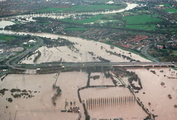
Growing Evidence That Human Emissions Fuel Extreme Weather, Flooding That Harms Humans, Environment. In 2000 England and Wales experienced the worst flooding since 1766, damaging or destroying 10,000 buildings, creating damage in excess of $1.3 billion. Here are the results of two new papers in "Nature", as reported by Climate Progress:
… in nine out of ten cases our model results indicate that twentieth-century anthropogenic greenhouse gas emissions increased the risk of floods occurring in England and Wales in autumn 2000 by more than 20%, and in two out of three cases by more than 90%."Scientists have predicted for decades that human-caused global warming would increased extreme weather events that cause severe harm to humans, property, and the environment. These two studies are but the latest in a growing body of scientific literature demonstrating that these predictions are coming true now. They should help lay to rest the myth that human-caused global warming will contribute to grievous harm only in some far-off future. They also strongly support the view that the human-induced increases in greenhouse gases have contributed to the devastating extreme events that hit Australia and other parts of the world in the past several months, helping to drive up food prices (see how extreme weather, climate change drive record food prices)."

No comments:
Post a Comment