.7" snowfall so far in February.
11" snow on the ground at MSP as of Sunday evening.
48 F. Sunday's high in the Twin Cities.
28 F normal high for Feb. 13.
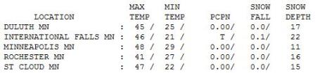
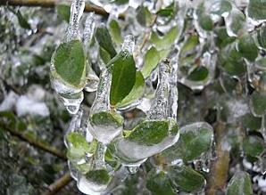
A Sight For Sore (Frozen) Eyes. No wonder we're all half-crazed, after the extreme changes we've seen this winter: from -11 F. Thursday morning to 48 Sunday afternoon. Hey, what's close to 60 degrees in less than 3 days among friends? It was the first 40 degree plus reading for the Twin Cities since December 30 (42F). We missed a record high by only 3 degrees (keep in mind the average high for Feb. 13 is 28 F. 40s swept across the state on gusty winds, in spite of 1-3 feet of snow on the ground. Pretty impressive, considering the cooling effect of that much snow chilling the air from below. St. Cloud soared to 47, an impressive 46 at International Falls, up from -34 early Thursday!

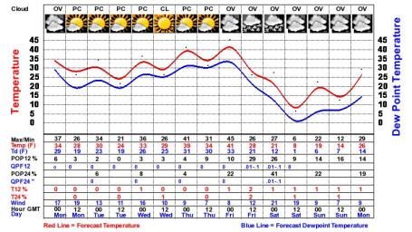
Shades Of March. Although today will be cooler than yesterday (to the tune of 10 degrees or so) expect more 40s by midweek, mid to upper 40s possible Wednesday and Thursday, nearly 20 degrees above average. The arrival of a colder front (bringing us back down to "average") by Friday may trigger a period of accumulating snow by the end of the week.
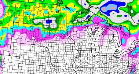
Reality Check. I suspect the GFS model may be overdoing the snowfall amounts by late-week, but a "few inches" may accumulate by Friday over parts of central and west central Minnesota as cold air comes rushing south of the border. Friday looks like a slushy, potentially sloppy day statewide.
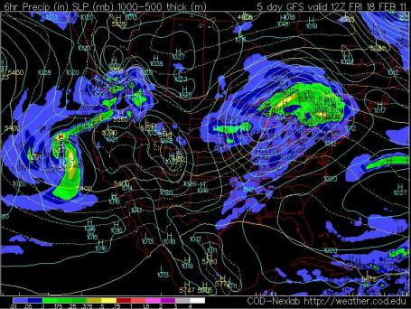
Friday Slap. After a hope-inspiring run of 40s Wednesday and Thursday Friday will be a rude awakening, a reminder that Old Man Winter is not nearly done with us yet. Not by a longshot. We'll see a few more subzero nights (no doubt), probably a few more days with highs in the teens, but I believe worst of the prolonged, subzero weather is probably behind us now. I hope that's more than wishful thinking on my part, but based on historical data (and the GFS model going out 15 days) I think the coldest nighttime lows, the 3-4 subzero nights/row of brutal weather, are now behind us. Time will tell if I'm just being a naive optimist.
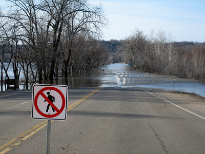
2010: Minnesota's Wettest Year. From Mark Seeley's excellent WeatherTalk blog: "The DNR-State Climatology Office has evaluated the climate data from last year in the context of state records since 1891 and concluded that on a statewide basis 2010 was the wettest year in history. The state averaged precipitation in 2010 was 34.10 inches surpassing the previous wettest year of 1977 which showed a statewide average of 33.74 inches. Total precipitation in 2010 ranged from less than 24 inches in parts of Cook County (far NE) to nearly 50 inches in Wabasha County. At least three dozen communities reported 40 inches or more of precipitation during 2010. September was the wettest month of the year averaging nearly 6.50 inches of rainfall among several hundred observers."
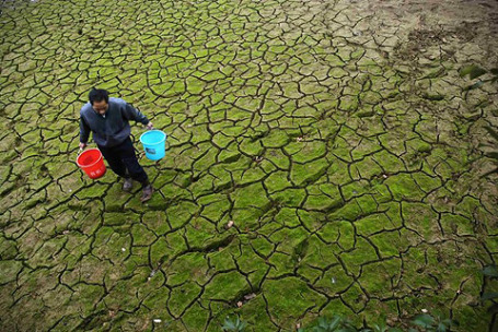
China To Spend $1 Billion To Alleviate Drought. Talk about tinkering with Mother Nature on a grand scale. An excerpt from USA Today: "BEIJING — China will spend $1 billion to alleviate its worst drought in six decades — a long dry spell in the world's largest wheat-growing region that threatens further jumps in the commodity's global price. The funding announced late Wednesday is part of a government plan to boost grain production, divert water, build emergency wells and take other steps in the affected areas in central and northern China. Snow fell Thursday in some of the driest areas, but it was minimal and has not eased worries about the winter wheat crop. The main wheat belt, including Shandong, Henan, Hebei, Anhui, Shanxi, Shaanxi, Gansu and Jiangsu provinces, has gotten virtually no precipitation since October.
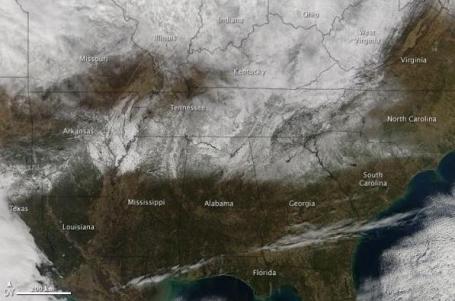
All hands on deck
The scientists marshaled instruments from Huntsville's airport, the "instrument farm" at the University of Alabama in Huntsville and NASA. The goal was to model the storm from the ground all the way to the top of the clouds. The team rolled out radars on trucks and dialed in radars at the airport. They set up normal rain gauges and rain gauges with lasers attached. The team turned on video cameras that can image the precipitation and radars that could tell if it was liquid or frozen. Still other instruments could pinpoint the location and size of snowflakes. The alphabet soup of instrument names included ARMOR, 2DVDs, PARSIVELs and MAX, many of which were waiting to deploy to Oklahoma to study tornadoes. Their stopover in Huntsville could not have come at a better time."
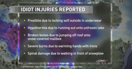
For Easteners This Winter Hurts More Than Usual. Winter-related injuries have (not surprisingly) spiked upward in recent months. From a story at USA Today: "At Hartford Hospital in Connecticut's capital, about two dozen people have been treated in the past week alone after falling off roofs and ladders while trying to clear snow. Others have lost fingers in snow-blower accidents, a few have suffered heart attacks while shoveling, and some have been sidelined with broken limbs after slipping on ice. "We've seen this before, but never in these huge numbers," said Dr. A.J. Smally, the hospital's emergency department director. "It's an epidemic."

* Thanks to WeatherNation meteorologist Todd Nelson for filling in last week on this blog (and the print column) while I was thawing out. I appreciate it LT!
Paul's Conservation Minnesota Outlook for the Twin Cities and all of Minnesota:
TODAY: Clearing, cooler, winds ease, cooler than average (but still 10 degrees milder than average) Winds:. NW 10-20. High: 38
MONDAY NIGHT: Partly cloudy. Low: 28
TUESDAY: Dim sun, windy, "above average". High: near 40
WEDNESDAY: More hints of spring. Some sunshine streaming through high clouds. High: 44
THURSDAY: Serious drippage. Drizzle possible - feels like March. High: 48
FRIDAY: Colder, mix turns to wet snow - a light, slushy accumulation is possible. High: near 30
SATURDAY: Colder, passing flurries, feels like February again. High: 24
SUNDAY: Chance of wet snow late. High: 30
Winter Survival 101
Living in Minnesota for 26 (winters) I've discovered a few tricks for maintaining some sense of sanity: wearing undershirts, investing in a good space heater, a sun-mimicking "full spectrum" lightbulb in my favorite reading lamp, and a few well-timed escapes. Is it me or is the ANTICIPATION of a southern vacation nearly as good as the actual get-away? Any guilt is quickly erased by returninto 2,000 e-mails, voice mails and urgent texts. Because none of us are expected to disconnect from The Matrix. My new definition of Heaven includes no bills (or Wi-Fi).
How the maps have changed, morphed, in the week I've been away. The jet stream has shifted, allowing Pacific air to finally chew away at those dagger-like icicles and glacier-size drifts in your yard.
Near 50 on February 13? Grilling weather! The greater the contrast in temperature, the faster winds have to blow to keep the atmosphere in equilibrium. That's why we'll see plenty of wind, fog and drizzle later this week as 40s return. Some new weather-words.
We'll see more snow and cold ahead, but the sun is as high in the sky now as late October. The upshot? The coldest subzero nights are now behind us. Hallelujah!

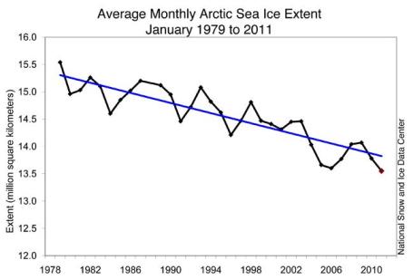
Record Arctic Sea Ice Loss in January, 2011. Some VERY strange things have been witnessed over the Arctic region this winter, from Alaska and northern/eastern Canada to Greenland - some things meteorologists have never seen before. Jeff Masters reports on the negatively-phased Arctic Oscillation, coupled with a persistent NAO (North American Oscillation) that funneled unusually mild air into much of the Arctic Region in December 2010 and January 2011 in his Wunderblog: "Arctic sea ice extent for January 2011 was the lowest on record for the month, and marked the second consecutive month a record low has been set, according to the National Snow and Ice Data Center.
....The warm temperatures in Canada and record sea ice loss in the Arctic were also due, in part, to a strong negative phase of the Arctic Oscillation (AO). The Arctic Oscillation and its close cousin, the North Atlantic Oscillation (NAO) are naturally occurring pressure patterns in the Arctic and mid-latitudes. A negative AO and NAO results when we have weaker than normal low pressure over the Arctic, and weaker than normal high pressure over the Azores Islands. This fosters an easterly flow of air off the warm Atlantic Ocean into the Canadian Arctic, and also weakens the winds of the polar vortex, the ring of counter-clockwise spinning winds that encircles the Arctic. A weaker polar vortex allows cold air to spill southwards out of the Arctic into eastern North America and Western Europe. Thus, the strongly negative AO and NAO the past two winters have been largely responsible for the cold and snowy winters in these regions, and exceptionally warm conditions in the Arctic."
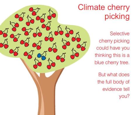
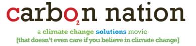
Climate As The New Dirty Word? In spite of overwhelming scientific evidence many people are still a). confused, or b). skeptical about climate change. Nothing like a cold, snowy winter to make a significant percentage of people fixate on (short-term) weather and miss the larger (long-term) global climate trends. Should we give up on trying to communicate climate science and focus on green energy (which should, over time, reduce carbon emissions). Focus more on (job-producing) new energy alternatives, less on the science, and hope that things just work out over time? From a Reuters article: "A new movie on climate change, called Carbon Nation, debuts this week. It’s positioned as the anti-Al Gore climate change movie. Basically, you don’t have to believe in the science of climate change to watch the movie and want to support clean power and greener transportation. While I’m not supporting ignoring science, there’s clearly been a growing movement around re-marketing climate change over the past few months, and I think that’s generally a positive move. In President Obama’s State of the Union Speech, he called for 80 percent clean power and touted green businesses, but didn’t state the issues of climate change head on, much to the dismay of environmentalists. But clearly, the climate change coinage isn’t working all that well. A year ago, the now-infamous Gallup poll found that almost half of Americans thought the threat of climate change was exaggerated. And as The Daily Show‘s John Stewart has spoofed so well, there’s been a lack of successful federal energy policy over the past eight Presidents. From the Obama administration’s perspective, why play into American skepticism? Instead, focus on the economic benefits of a green economy."
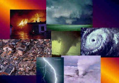
$110 Billion In Climate Change Damage In 2010. A U.K. climate researcher reports 375 natural disasters across the planet last year which may have been impacted by a warmer (stormier) atmosphere, resulting in an estimated 300,000 deaths, displacing some 207 million people. More details here.
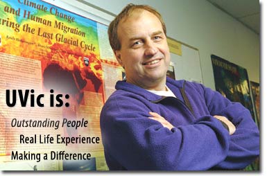
Climate Scientists Sues Skeptic For Libel. A story from the New York Times: "A prominent Canadian climate scientist is suing a leading climate skeptic for libel, arguing that an article published online in January contained false and malicious claims. Andrew Weaver, a climate modeler at the University of Victoria, filed the lawsuit against Tim Ball, a former professor of geography at the University of Winnipeg and a vocal critic of the science linking man-made emissions to global warming, over an article published by the Canada Free Press, a conservative Web site. The article described Dr. Weaver, who was lead author for the 2007 United Nations Intergovernmental Panel on Climate Change, as lacking a basic understanding of climate science and incorrectly stated that he would not take part in the next I.P.C.C. panel because of concerns about its credibility. Dr. Weaver is already involved in the preparation of the next report from the panel and has never said that he was ending his involvement with it."
No comments:
Post a Comment