Paul's Conservation Minnesota Outlook for the Twin Cities and all of Minnesota:
TODAY: Dim sun, windy and milder. Winds: SW 15-25. High: 41
TUESDAY NIGHT: Partly cloudy, milder than average. Low: 27
WEDNESDAY: Shades of March, pothole weather. More clouds than sun. High: 43
THURSDAY: Clouds, fog and drizzle. Hints of spring in the air. High: 47
FRIDAY: Light snow and flurries, falling temperatures. High: 28 (falling during the day)
SATURDAY: Plenty of sun, heavy jackets return. High: near 30
SUNDAY: Chance of light snow, flurries. High: 36
MONDAY: Wet snow, possibly mixing with ice/rain. Potential for a few slushy inches? High: 35
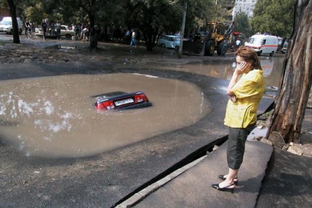
Going Fast. As of 7 pm Monday there was only 6" snow on the ground at MSP International Airport. That's a loss of 5" in one day. Actually, it's probably a good thing we're losing some of this snow now, in mid February. It may alleviate some of the flood risk in late March.
 February Data
. On February 1 MSP had 14" of snow on the ground, with 11" reported Sunday evening, the 13th. I can't remember the last time we lost 5" in a 24 hour period.
Data from the Minnesota State Climate Office.
 Pothole Weather
. Ah, the freeze-thaw cycle is upon us (1-2 weeks ahead of schedule I might add). Water has the unpleasant tendency to expand when it freezes. That means during the daylight hours water gets into tiny cracks in highway surfaces, and at night that liquid water expands as the mercury dips below 32 F. Over time this literally pulverizes, shreds the highway surface. Add a few thousand cars passing over this brittle surface and you can wind up with some crater-size potholes. Nothing quite this bad (I pray), but I can't remember seeing so many hubcab-eating potholes lurking out there. All you can realistically do is slow down (and try not to swerve into oncoming traffic).
 Too Early To Retire The Shovel?
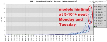
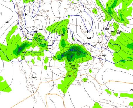
 Just when you thought it was safe to exhale. Nothing definitive yet - but the models are strongly hinting at accumulating snow early next week, one GFS model even suggesting a potential for a foot. That may be pushing it, but this will be a slow-moving, southern storm, tapping moisture from the Gulf of Mexico. it may also be a long-lasting snow event, possibly 36 hours of precipitation. The catch? A thin layer of warm air aloft may change snow over to rain (or an icy mix), especially south/east of the Twin Cities. There's no way to know (yet) where that rain/snow line will set up. We'll obviously keep an eye on this, see if there is continuity from one model run to the next, and if the models converge on a believable solution.
Let me make this perfectly clear: I do NOT think we'll see a foot of snow early next week. A few slushy inches? Possibly. No cause for panic, loathing or mass evacuation.....not yet.
More Like March. The GFS prints out over 1" liquid, most of the precipitation coming next Monday. The big difference this time around? Surface temperatures may be close to freezing, maybe even some low to mid 30s. With a higher sun angle and longer daylight that could translate into wet/slushy roads much of the day, with most accumulation on lawns, fields and side-streets. This won't be like January, when heavy snow was falling at 5-15 degrees F, making it virtually impossible for MnDOT to keep roads clean.
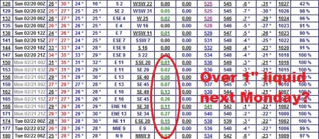
A Close Call Next Monday-Tuesday? GFS model valid 1 pm Monday afternoon, showing the heaviest rain/snow staying just south/east of the Twin Cities, but a track way too close for comfort. Confidence level is still low (any snow event is still 5-7 days away) but there are growing signs of a potentially significant (slushy) snowfall early next week, possibly starting late Sunday and lingering into Tuesday. The GFS prints out over 1" of liquid, much of it probably falling as snow, although a snow/rain mix can't be ruled out with temperatures in the lowest mile of the atmosphere close to freezing. It's way too early to answer the troubling "how many inches Paul!" question - but let's just put it in the "potentially plowable" category right now. With any luck surface temperatures will be in the low/mid 30s, keeping most freeways/interstatest wet/slushy.
From Sandbags To Home Removals, Cities Prepare For Floods Again. The Star Tribune's Bill McAuliffe
reported late last week about flooding already underway up in Wilkin county - a possible omen of what's to come. Here's an excerpt: "
Ice is still on the rivers, but the flood fight is on. With near-historic crests predicted for the third year in a row, people along the state's flood-prone waterways are sandbagging, strengthening their defenses, and watching with confidence, wariness and weariness. Fargo-Moorhead, the epicenter of recent flood fights, have both declared states of emergency. On Monday, Fargo will launch a drive to fill 3 million sandbags to hold off the Red River in North Dakota. Along the Minnesota, the Mississippi, the St. Croix, and even along tributary creeks, communities are buying sandbags, hiring levee builders, planning for volunteers and prodding residents to buy flood insurance."
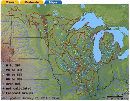
Updated Flood Threat. According to the North Central River Forecast Center (a division of NOAA focused on river flood forecasting) the risk of major flooding is over 80% on the Mississippi River from St. Paul to Hastings and Red Wing. There's also a very high risk of river flooding on the Red River north of Fargo/Moorhead. More details can be found
here.
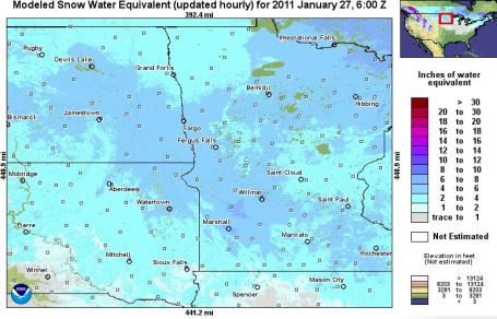 Snow Water Equivalent.
 NOAA's Hydrological Remote Sensing Center has an
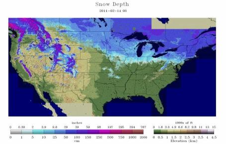
interactive tool that allows you to calculate how much water is locked up in the snow. My eyes are shot, but I think the metro is in the 4-6" of liquid water range, with a few small patches of 6-8" over southwestern Minnesota, south/west of Willmar. Again, the rate of melting will be determined by how fast we warm up in late February and March (gradual or sudden) and the presence of rain, which would accelerate snow-melt and heighten the risk of serious river flooding.
Melting Snow. This week's shift in the jet stream is allowing mild, Pacific air to finally cross the Rockies and warm up much of the lower 48 - melting snow in a hurry. Check out how much snow has melted in just 4 days: this time lapse, from Feb. 10-14, courtesy of
Twitpic.
Lapland - 100 Straight Days Of Subzero Weather. Think we had a cold winter? You won't get much sympathy from
folks in the hinterlands of Finland. We're talking SERIOUS cold: "
As of Monday, the capital of Finnish Lapland, Rovaniemi, had passed one hundred days of continuous sub-zero weather. The thermometer there fell below the freezing point on November 4th and the cold continues. According to statistics, the city has now moved into the fifth longest period of sub-zero temperatures in the past 50 years, reports Meteorologist Jorma Koskela of the Finnish Metrological Institute. The present cold snap has also brought this winter's record low in Lapland where -37.9 degrees Celsius was recorded in the early hours of Monday."
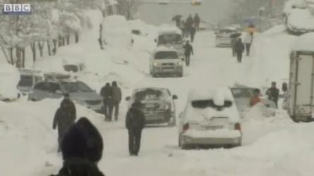
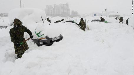
Record Snows Hit Korea. Yes, this winter it appears almost everyone is getting a "taste". The BBC
reports on the coldest January in Korea's modern-day history records, followed by waves of heavy snow: "
The heaviest snowfall in more than a century on South Korea's east coast is causing widespread chaos. Hundreds of houses have collapsed under the weight of the snow. One newspaper described it as a snow bomb. The South Korean government has deployed 12,000 soldiers to rescue stranded residents. The worst weather has been in Gangwon province. Weather experts say there will be more snowfall in the area in the coming hours."
Soldiers To The Rescue. More on the amazing Korean snow-dump in this
update from CNN: "
South Korean soldiers were digging out cars and searching for trapped residents Monday as areas along its eastern coast tried to recover from the biggest snowfall in 100 years. More than 39 inches (1 meter) of snow blanketed the area over the weekend, according to the Yonhap news agency. The city of Gangneung got more than 30 inches (77.7 centimeters) on Friday alone, Yonhap said, the most ever recorded since record-keeping began in 1911."
Rare Atlanta Winter. Examiner weather reporter Kirk Melhuish
reports on the third "abnormal" winter in a row for the Atlanta area. You may need a LinkedIn account to see the details:
"
For at least the second time this winter, following Atlanta's snowfall this week, snow was on the ground in every state of the Union except Florida. Clearly a most unusual winter. It's not that we have had extreme low temperatures, quite the contrary. It's just the persistence of below-normal temperatures on average and, until now, the lack of the mild spells Atlanta normally sees during the course of a winter. Also, like last winter, the frequency of snow or ice events and threats of them for a close call have been far more numerous than average. Since 1895 statewide December and January were the third coldest on record in Georgia just behind the winters of 1917-18 and 1976-1977. December was the coldest statewide in the Peach State in 116 years."
Lindsey Vonn Suffers Concussion at World Skiing Championship in Germany. The pride of Minnesota, Lindsey Vonn, will skip remaining events in Garmisch, Germany, after suffering a concussion. Here's the latest
update from the Denver Post: "
Vail's Lindsey Vonn has decided to skip the remaining events at the world alpine championships, hoping that nine or 10 days away from skiing will allow her to overcome the lingering effects of a concussion she suffered Feb. 2. Vonn won a silver medal in downhill Sunday, .44 of a second behind gold medal winner Elisabeth Goergl of Austria. She will miss the world championships slalom and giant slalom, her weakest events."
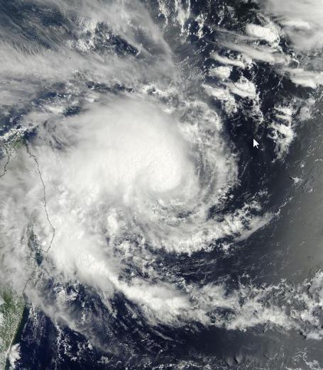
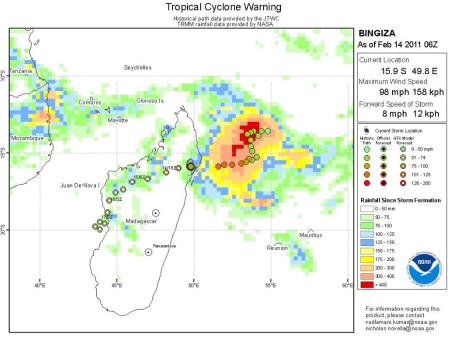
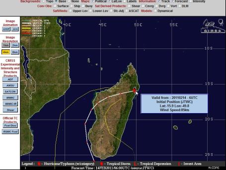
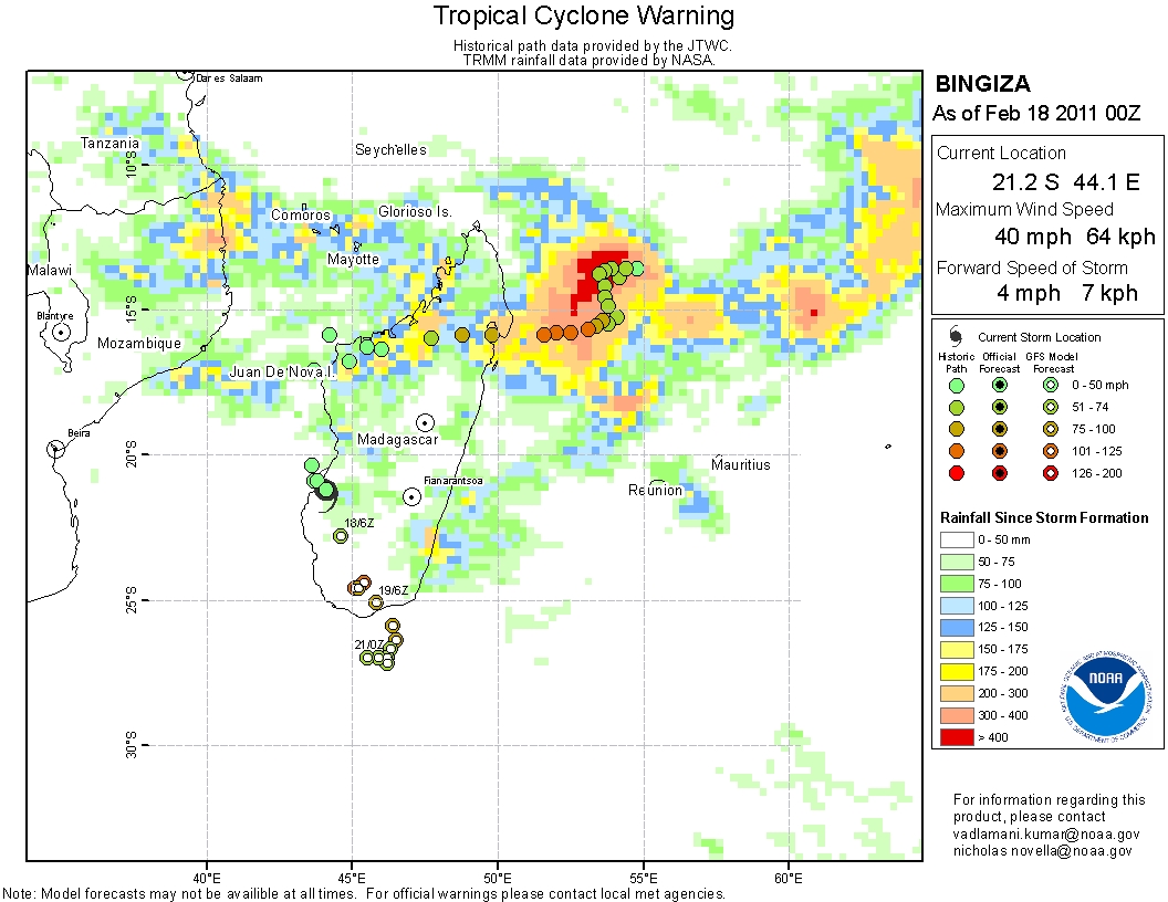
Cyclone Bingiza. Australia is cleaning up from a recent Category 5 cyclone (same thing as a hurricane). Now it Madagascar's turn. Click
here to see projected rainfall amounts, the predicted track of this category 1 cyclone is
here, courtesy of the University of Wisconsin meteorology department. More on "Bingiza" from Jeff Masters on his
Wunderblog.
"Atmospheric Rivers". An interesting
article from NOAA: "
Atmospheric rivers are relatively long, narrow regions in the atmosphere – like rivers in the sky – that transport most of the water vapor outside of the tropics. These columns of vapor move with the weather, carrying an amount of water vapor roughly equivalent to the average flow of water at the mouth of the Mississippi River. When the atmospheric rivers make landfall, they often release this water vapor in the form of rain or snow.
Although atmospheric rivers come in many shapes and sizes, those that contain the largest amounts of water vapor and the strongest winds can create extreme rainfall and floods, often by stalling over watersheds vulnerable to flooding. These events can disrupt travel, induce mudslides and cause catastrophic damage to life and property. A well-known example is the "Pineapple Express," a strong atmospheric river that is capable of bringing moisture from the tropics near Hawaii over to the U.S. West Coast.
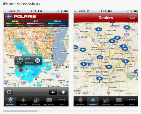
Polaris Snow Trails. This is a new and
FREE app, for your iPhone or iPad, one that WeatherNation has been working on for the last few months. You can not only see (every) snowmobile trail in the USA, with radar and snow amounts (and predictions) superimposed over your GPS location - or any location for that matter, you can also click on any point to get current conditions, a 5-Day forecast (day by day snowfall amounts), nearest restaurants, bars, hotels, directions how to get there - you can even save favorite snowmobile trips and share them with your buddies. All for free. More information on the app
here, courtesy of our good pals at Apple.
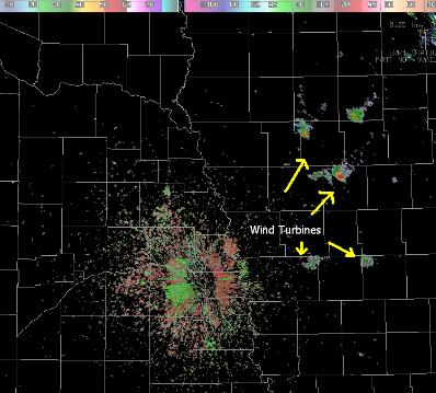
Wind Turbines Showing Up On Doppler Radar? Breaking
news from the Omaha office of the National Weather Service: "
According to the Nebraska Public Power District, the Laredo Ridge wind farm near Petersburg became operational Tuesday, February 1, 2011. Laredo Ridge, located 3 miles northeast of Petersburg, Nebraska currently has 27 wind turbines and is expected to increase to 54 turbines when the project is completed." (ps: this makes meteorologists and professional storm chasers absolutely nuts).
Study Calculates Humanity's Information Capacity - But We're Still Running Second. Feeling overwhelmed? Well no wonder. Talk about drowning in data. Gizmag.com puts the information-overload into stark perspective in a mind-boggling
article; here's an excerpt: "
The research team from the University of Southern California (USC) examined the period from 1986 to 2007 and calculated that, including both analog devices and digital memory, in 2007 humankind was able to store at least 256 exabytes of information – an exabyte is equal to one quintillion bytes or one billion gigabytes. Despite all those zeroes, that’s still less than one percent of the information stored in the DNA molecules of a single human being. From 1986 to 2007 storage capacity grew at a rate of 23 percent a year. In 2002, worldwide digital storage capacity overtook analog capacity for the first time and within five short years, almost 94 percent of humankind’s information storage was in digital form – a figure that is sure to be even higher now."
Cruise From Hell. Comedy Central's Tosh O has a
clip on his site which might make you reconsider that upcoming cruise. Actually, it kind of looks like fun (if you've got a fisful of Dramamine patches and a good sense of humor). Good grief.
Strangest Live Shot...Ever? Not sure what was going on here. I hope it's not a medical issue, but click
here to see (and hear) KCBS-TV reporter Serene Branson during a live shot with anchor Paul Magers - and what may be the strangest live shot in the history of local television news. More from mediabistro.com
here.
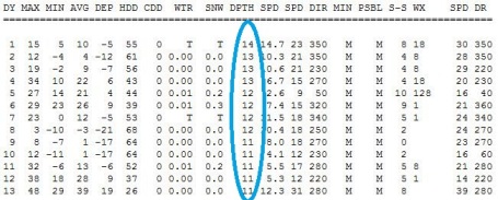
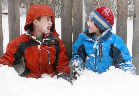
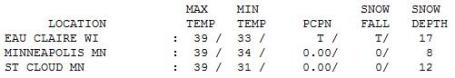
Valentine's Day 2011. Yes, it felt more like early March out there yesterday, a high of 39 in the Twin Cities and St. Cloud. In the metro area snow on the ground shrank from 11" Sunday to 6" as of Monday evening at 7 pm. St. Cloud still has a cool foot of snow on the ground.
Data below for MSP, courtesy of the National Weather Service.
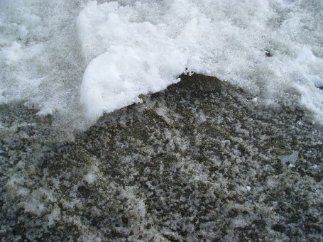
Dirty Snow
Think we've had a cold winter? 16 subzero nights so far at MSP, roughly half the number we experience during an average winter. Whatever THAT is. You won't get much sympathy from folks living up in Lapland, Finland. The capital of Rovaniemi just passed 100 days in a row below zero, the 5th longest subzero stretch in 50 years. Minnesota would be Club Med for a Laplander. Everything is relative, right? That's why 48 F. on Feb. 13 feels SO much better than 48 F. in mid November.
February snowfall has been minimal, less than an inch so far. Compare that with 19" at Oklahoma City and over 14" in Huntsville, Alabama! What a strange pattern.
A taste of March arrives the next 3 days as Pacific air swirls into town, highs poking into the 40s, the freeze-thaw cycle carving out crater-size potholes (and slippery sidewalks/driveways each morning). A Friday clipper brushes us with a little snow; it will feel like February by late week. The latest models are hinting at a sloppy southern storm passing just south/east of Minnesota early next week, capable of throwing a few inches of slush into area yards by Monday and early Tuesday. But we've turned a big corner and now the concern is focused on flooding. Will the thaw be gradual? Will heavy March rains accelerate snow-melt? An estimated 3-6" of liquid water is trapped in that grizzled, stubbly snow pack. Our fingers are crossed.
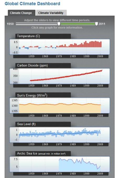
Climate "Dashboard". Check out NOAA's interactive climate
dashboard, where you can move the timeline around and see how everything from sea levels to Arctic Sea ice to carbon dioxide levels and surface temperatures have changed since 1950.
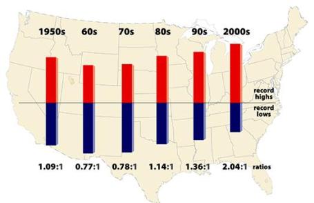
Record High Temperatures Far Outpace Record Lows Across U.S. A 2009
report from NCAR, the National Center for Atmospheric Research, showed a fairly pronounced trend in recent decades: twice as many record highs as record lows from 2000-2009. An excerpt: "
BOULDER—Spurred by a warming climate, daily record high temperatures occurred twice as often as record lows over the last decade across the continental United States, new research shows. The ratio of record highs to lows is likely to increase dramatically in coming decades if emissions of greenhouse gases continue to climb. "Climate change is making itself felt in terms of day-to-day weather in the United States," says Gerald Meehl, the lead author and a senior scientist at the National Center for Atmospheric Research (NCAR). "The ways these records are being broken show how our climate is already shifting."...... If temperatures were not warming, the number of record daily highs and lows being set each year would be approximately even. Instead, for the period from January 1, 2000, to September 30, 2009, the continental United States set 291,237 record highs and 142,420 record lows, as the country experienced unusually mild winter weather and intense summer heat waves. A record daily high means that temperatures were warmer on a given day than on that same date throughout a weather station's history. The authors used a quality control process to ensure the reliability of data from thousands of weather stations across the country, while looking at data over the past six decades to capture longer-term trends. This decade's warming was more pronounced in the western United States, where the ratio was more than two to one, than in the eastern United States, where the ratio was about one-and-a-half to one."
Increasingly Variable Summer Rainfall In Southeast Linked To Climate Change. An
article from Duke University on the shifting rainfall patterns across the southeastern USA: "
DURHAM, N.C. – A new study by a Duke University-led team of climate scientists suggests that global warming is the main cause of a significant intensification in the North Atlantic Subtropical High (NASH) that in recent decades has more than doubled the frequency of abnormally wet or dry summer weather in the southeastern United States. The NASH, commonly referred to as the Bermuda High, is an area of high pressure that forms each summer near Bermuda, where its powerful surface center helps steer Atlantic hurricanes and plays a major role in shaping weather in the eastern United States, Western Europe and northwestern Africa."


No comments:
Post a Comment