60.4" so far this winter in the Twin Cities.
Trace of snow fell on Tuesday.
14" snow on the ground at KMSP.
Paul's Conservation Minnesota Outlook for the Twin Cities and all of Minnesota:
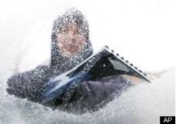
TODAY: Windchill Advisory Twin Cities metro - Wind Chill Warnings for central/western MN for a chill factor near -35 F. this morning. Coldest day of the week. W.C. -20. W 10-15. High: 9
WEDNESDAY NIGHT: Clear to partly cloudy, still cold. Low: -3
THURSDAY: Fading sun, breezy, not as cold. Low: -3. High: 18
FRIDAY: Milder, coating-1" or so of snow from late clipper? Low: 17. High: 33
SATURDAY: Cooler, clouds and flurries linger. High: 27
SUNDAY: Dry start, more light snow Sunday night - light accumulation possible Sunday night . High: 23
MONDAY: Chance of a few inches of light snow, tapering to flurries, much colder. Low: 8. High: 12
TUESDAY: What else? Cold with some sun. Low: -5. High: 7
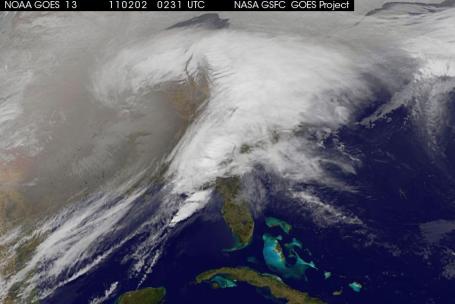
 Satellite Shows Winter Megastorm Painting U.S. White
. A great
photo from NASA, courtesy of wired.com: "
A NASA photograph of the Midwest megastorm gives profound visual truth to what it means for a snowstorm to blanket the United States. The image was captured from space Jan. 31 by the GOES 13 satellite, which regularly photographs the Eastern half of the planet from a geosynchronous altitude of about 22,000 miles. Cold air from the north is diving southward and colliding with moist tropical air, covering one-third of the United States in clouds. The storm is expected to flow east and depart New England on Wednesday night. Forecasters expect the storm will break snowfall records in the Great Plains and central Midwest. In the East, it may deliver ice storms that could cause $1 billion in damage. It’s the latest in a string of storms fitting a pattern predicted by climate scientists. Rising temperatures allow air to hold more moisture, loading storm systems with precipitation that’s ultimately dumped back on Earth."
The Great Groundhog Day Storm of 2011. Infrared satellite image courtesy of
NOAA. From space storms look like "comma clouds", or giant atmospherically-shaped question marks, which seems somehow appropriate.
Serious Drifts. Thanks to Nick Harley from
severestudios.com for reminding us what 10 foot drifts look like. This photo was taken in Elkton, South Dakota.
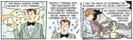
Growing Risk of (Warranted) Weather Hype. O.K. The hyperbole and hand-waving has reached new, unthinkable levels in the last 48 hours. I wanted to include this
Sally Forth comic by Steve Alaniz & Francesco Marciuliano; drawn by Craig MacIntosh. H/T Steve Tracton
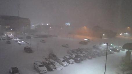
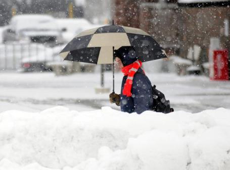
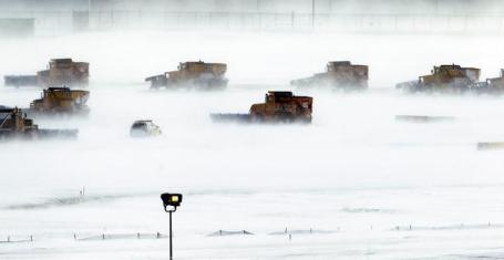
Chicago: Definition of "Snowmageddon." Meteorologists get a lot of grief (some of it justified) for hyping the weather, but not an ounce of hype was needed Tuesday night in Chicago. Horizontal snow, white-out conditions, winds gusting to 58 mph (!) with thunder and lightning! It must have looked like a snowy End Of The World. Lakeshore Drive was impassable, closed, in its entirety, due to abandoned vehicles. It was the very definition of a blizzard. Final amounts? 18-22", but good luck measuring - some 6-8 foot drifts are likely by midday today. (I saw a live shot on CNN last night when it thundered as the reporter-on-the-scene was trying to remain upright - I thought he was going to faint, loud, booming thunder with near-zero visibilities. Amazing).
Peak Wind Gusts (up until 9 pm Tuesday). Data courtesy of EarthNetworks.
Chicago Lakefront: 67 mph
Chicago Ohare: 61 mph
Aurora: 59 mph
West Chicago: 54 mph
Joliet: 52 mph
Dekalb: 52 mph
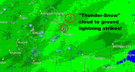
* From Jeff Masters and his
Wunderblog: "
The storm will probably be Chicago's biggest blizzard since January 2 - 4 1999, when a storm dumped 21.6" of snow. With tonight's snowstorm expected to have very unstable air aloft, "thundersnow" with snowfall rates of 4 inches/hour is possible, and there is a chance today's blizzard could rival Chicago's greatest snow storm of all time, the blizzard of January 26 - 27, 1967. That immense storm dumped 23 inches of snow on Chicago, stranding thousands of people and leaving an estimated 800 Chicago Transit Authority buses and 50,000 automobiles abandoned on the city streets and expressways."
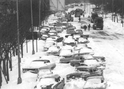
Storm For The Ages. All-time snowfall record from a single storm in Chicago? 23" on January 35-26,1967. There was so much snow that roads were closed for days after the storm, in some cases WEEKS. 60 deaths were attributed to the storm (many from heart attacks). Keith Heidorn, the "Weather Doctor" has a terrific write-up on the storm to end all storms
here. (photo credit: Chicago's Outer Drive, from 12th to 16th Street, courtesy of Keith Heidorn).
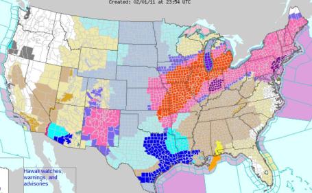
Lit Up Like A Christmas Tree. 9 states under Blizzard Warnings, 20 states impacted by Winter Storm Warnings, tornado watches and warnings for the Deep South, a slew of Windchill Warnings and Advisories (including much of Minnesota). Oh to be in south central Oregon, where the biggest concern is an Air Stagnation Advisory. Click
here for the latest warnings from NOAA.
NASA Satellites Capture Images Of Monster Storm Affecting 30 States. From our friends at NASA: "One of the largest winter storms since the 1950s is affecting 30 U.S. states today with snow, sleet, freezing rain and rain. NASA satellites have gathering data on the storm that stretches from Texas and the Rockies to the New England states. NASA's Aqua and Terra satellites have been providing visible, infrared and microwave looks at the storm system's clouds, precipitation, temperatures and extent." More details
here.
Weather "Bomb". In meteorological circles a "bomb" is an explosive storm, one that's intensifying rapidly. Tuesday's storm fit the definition: 8 foot drifts in Oklahoma, interstates closed across Missouri, 5" of snow in 90 minutes, hundreds of motorists stranded in their vehicles, 20"+ for parts of Oklahoma and Missouri, the first-ever "hard freeze warning" for the Dallas area, the first blizzard warning in recent memory for St. Cloud - here's a great
overview of the storm from the Capital Weather Gang.
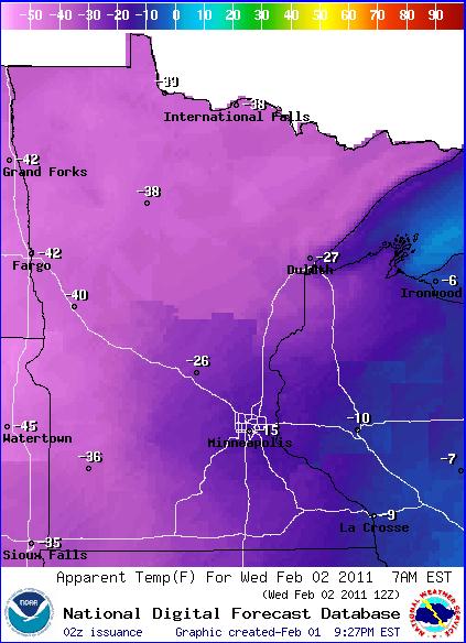
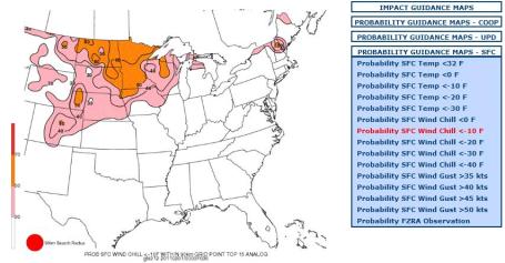
Bottoming Out. Today will be the coldest day of the week, morning wind chills in the -15 to -25 F range in the Twin Cities, but as cold as -40 over western Minnesota, where Wind Chill Advisories have been upgraded to Warnings.
URGENT - WINTER WEATHER MESSAGE
NATIONAL WEATHER SERVICE TWIN CITIES/CHANHASSEN MN
...DANGEROUS WIND CHILL READINGS WEDNESDAY MORNING...
..A WIND CHILL WARNING REMAINS IN EFFECT FOR WEDNESDAY MORNING FOR AREAS OF WEST CENTRAL...CENTRAL AND SOUTH CENTRAL MINNESOTA. THE WIND CHILL WARNING AREA IS GENERALLY ALONG AND WEST OF A LINE FROM STAPLES TO LITCHFIELD TO FAIRMONT. A WIND CHILL ADVISORY REMAINS IN EFFECT FOR TONIGHT AND WEDNESDAY MORNING FOR AREAS OF EAST CENTRAL AND SOUTHEAST MINNESOTA...INCLUDING THE TWIN CITIES METROPOLITAN AREA. THE COMBINATION OF COLD TEMPERATURES TONIGHT AND WIND SPEEDS HOLDING IN THE 10 TO 20 MPH RANGE...WILL DRIVE WIND CHILL READINGS DOWN TO THE 30 BELOW TO 40 BELOW ZERO RANGE IN THE WIND CHILL WARNING AREA
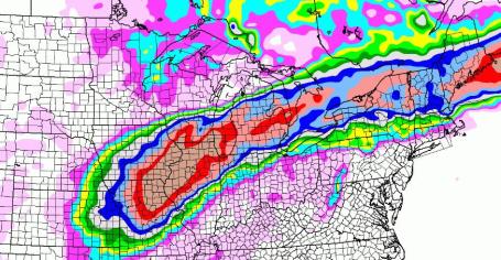
A Memorable Swath Of Snow. The latest NAM model prints out over 20" (total) for parts of Missouri, Illinois and Lower Michigan, the heaviest snows passing north of New York and Boston. This will be the biggest snowstorm in well over a decade for parts of the Midwest and Great Lakes.
Historic Winter Storm? All hype and superlatives aside, this storm is a pretty big deal: impacting at least a third of the nation. 8 states under Blizzard Warnings - 30 states under Winter Storm Warnings. As many as 100 million Americans are being impacted by heavy snow, severe ice and bitter wind chills - possibly the most disruptive winter storm in at least a decade.
More from the Huffington Post:
"
A monster winter storm took aim at a third of the nation Monday, threatening to lay a potentially deadly path of heavy snow and ice from the Rockies to New England, followed by a wave of bitter, bone-rattling cold that could affect tens of millions of people. Cities including St. Louis, Kansas City and Milwaukee could be hardest hit, with expected midweek snowfalls of up to 2 feet and drifts piled 5 to 10 feet. Even hardy Chicago could be in for its third-worst blizzard since record-keeping began. "I wouldn't want to be on the road in open areas tomorrow night," said forecaster Tom Skilling of Chicago television station WGN. "I don't think I'd want to be driving in the city either. The fact is people die in these things. They skid off the road and go wandering around in whiteout conditions." Warmer areas were not safe, either. The system could spawn tornadoes in parts of the South. While record snowfalls have pounded the Northeast in one of that region's most brutal winters, the Midwest has been comparatively unscathed, until now."
8 Foot Drifts In Oklahoma. From our partners at EarthNetwork (formally WeatherBug): "Conditions have deteriorated to no visibility and up to 8 foot drifts on the interstates. National Guard is working with OHP (Oklahoma Highway Patrol) to rescue stranded motorists. White out conditions exist at this time. No travel through area recommended." YouTube footage of the blizzard in Tulsa is
here.
Aviation Gridlock. 6, 887 flight cancellations in the USA as of 9:30 Tuesday evening, according to
flightaware.com. American Airlines got the Golden Sleeping Bag Award. Sign me up for Caribbean Airlines - only 1 flight (maybe the only flight?) disrupted by Tuesday's super-storm.
Ski Oklahoma. Jason Parkin included a great photo of the aftermath of the blizzard in Oklahoma. Looks more like North Dakota. Check out more photos and storm-nuggets at his excellent blog,
dsmweather.com.
...OKLAHOMA...
MIAMI                                20.0
OWASSO 1 W                           19.0
AFTON                                18.0
PAWHUSKA 2 S                         17.0
TULSA 9 SE                           15.0
VINITA                               12.0
GLENPOOL                             11.0
(Snowfall reports from NOAA's NCEP division. More snowfall totals
here).
Groundhog Day Cancelled In Illinois. From EarthNetworks: "The snowy weather is so bad even Woodstock Willie isn’t coming out Wednesday — Groundhog Day — to forecast how much longer winter will last, organizers of the Groundhog Days festival in northwest suburban Woodstock announced Tuesday. A highlight of the annual festival is the furry critter emerging from his tree trunk home in the downtown Woodstock Square, where parts of the 1992 hit movie “Groundhog Day” were filmed. “Due to the weather conditions and with concern for safety, the Feb. 2 prognostication has been cancelled for 2011,” the Groundhog Days Committee said on its website.
January Snow In St. Cloud More Than Previous Five Januarys - Combined. A
story from Dave Aeikens at the St. Cloud Times: "So much so that the 15.6 inches that fell this January, including 4.4 inches of new snow Monday, is more than fell during the five previous Januarys combined. 15.1 inches of snow fell during the Januarys of 2006-2010, according to Bob Weisman, St. Cloud State University meterologist. Guys like Keith Marthaler, president of the Sno Joes Snowmobile Club, like to see the white Januarys. “It’s been a great year for snowmobiling; a very good season. The snow has been good,” Marthaler said. “Snowmobile season is in full swing, everybody is happy. ”It snowed 16 of 31 days in January but, typical of most Januaries when the air is too cold for a prolonged snowfall, it didn’t snow more than 2 inches until Monday, Weisman said. “We had a lot of those very fluffy snowfalls,” Weisman said.
WindChill Concerns. NOAA is
tracking the severe cold engulfing the nation in the wake of what may go down in the record books as one of the most disruptive winter storms in a decade or more. Wind chill values may reach -20 to -30 at time early Wednesday.
January Numbers. According to the meteorological analytics company, Planalytics, January was the 4th coldest and 6th snowiest on record. More details: "
North America ended the month colder and drier than normal, although regional differences were prevalent. The U.S. had its coldest January since 2004, driest since 2009, and snowiest since 2005. Canada was colder than last January although still warmer than normal and the most precipitation since 2008. Snowfall in Canada was near normal although well above last year." (photo courtesy of the New York Times).
Tuesday's Forecast: Horrific. Snow budgets in many municipalities around the USA have already been spent, and the winter snow accumulation season is a little more than half over. The New York Times
reports on the many ways Old Man Winter is adding insult to injury for many states and cities around the nation: "
KANSAS CITY, Mo. — Government budgets around the nation, already busted by the bad economy, now have a new nemesis: Mother Nature. Yet another winter storm is going to heap more ice and snow across a huge section of the country this week, meaning yet another big bill, on top of a lot of other big bills, for all the towns and cities that have to dig out again. “On a weather map, some people see snowflakes, I see dollar signs,” said R. T. Rybak, the mayor of Minneapolis, as a light snowfall brightened the white mounds lining the city streets. Not that officials have any choice. The streets have to be cleared, of course, but often with fewer plows and less salt than in years past. Many cities — New York among them — have already overspent their snow budgets and many more expect this storm to push them into the red. In Minneapolis, a record-setting series of snowstorms in December pushed the city over the snow-removal budget for 2010 by $3.3 million — more than the city spends on pothole repairs for the entire year."
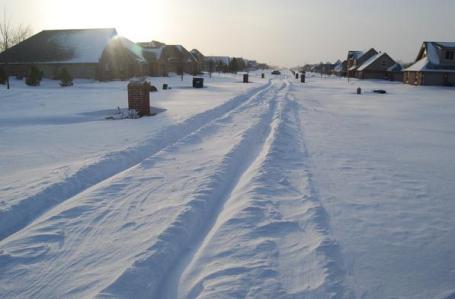
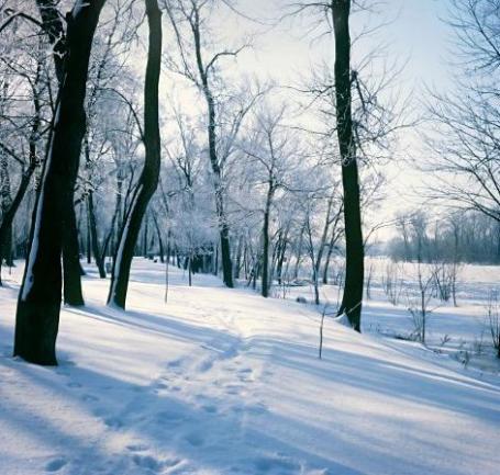
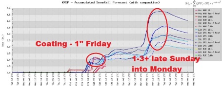
Nothing On The Doppler - Yet. We get a break through Thursday, this latest influx of Canadian air forcing the storm track well south of Minnesota. Models are suggesting a coating to an inch during the PM hours Friday, maybe a few more inches late Sunday and Sunday night. At the rate we're going we may have close to 70" by mid February.
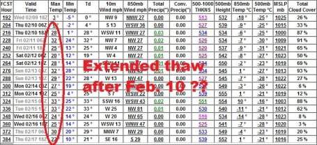
The End Is Near? (To The Coldest Air Of Winter) The GFS is suggesting another cold swipe early next week, but then an extended stretch of time in the 20s and low 30s. It's the first real hint of an EXTENDED
THAW I've seen yet this winter. We've picked up nearly 1 hour of additional daylight since December 21 - looks like that higher sun angle may finally make a dent in our temperature pattern by the end of next week into the third week of February. Hang in there - better days ahead.
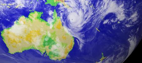
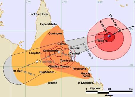
Category 5 Cyclone Yasi. The cyclone (same thing as a hurricane) threatening Queensland continues to intensify. "Yasi" may hit as a Category 5, with sustained winds over 150 mph - a potentially devastating storm impacting the same area that was overwhelmed with flooding rains a few weeks ago.
Collision Course. Yasi is expected to hit the coast of Australia, near Cardwell, during the early morning hours (local time) Feb. 3.
Track data from the Australian Bureau of Meteorology.
*
Australians Flee, Jam Shelters Ahead Of "Catastrophic Cyclone." The
latest from Reuters on what may be a devastating hurricane for Queensland: "
We are facing a storm of catastrophic proportions," Queensland state premier Anna Bligh said after Cyclone Yasi was upgraded to a maximum-strength category five storm. It is expected to hit the coast on Wednesday evening, packing winds in excess of 280 km (175 miles) per hour. The weather bureau predicted it would be the strongest ever to hit Australia, Sky TV reported. "All aspects of this cyclone are going to be terrifying and potentially very very damaging," Bligh added, noting the greatest threat to life could come from storm surges along the coast with the system due to hit when the tide is high.Mines, rail lines and coal ports have all shut down, with officials warning the storm could drive inland for hundreds of kilometres, hitting rural and mining areas still struggling to recover after months of devastating floods."
"An updated cyclone warning from Queensland disaster officials said: "Severe tropical cyclone Yasi is a large and very powerful tropical cyclone that poses an extremely serious threat to life and property. This impact is likely to be more life threatening than any experienced during recent generations."
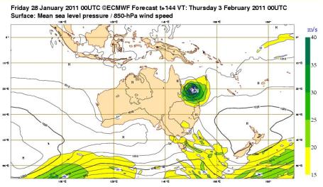
Direct Strike. ECMWF model track of Cyclone Yasi is
here.
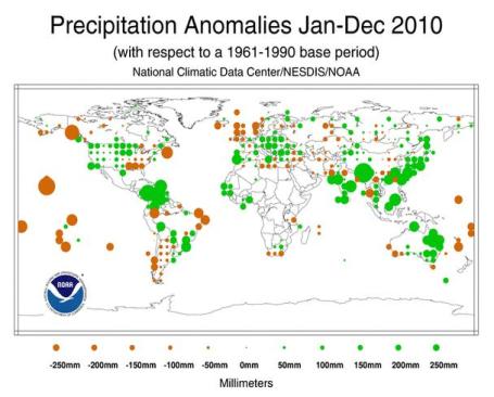
2010: Wettest Year On Record. According to NCDC last year not only tied 2005 for the warmest year since 1880, it was also the wettest year. A 1-2 F. temperature increase in the last century has evaporated more ocean water, leading to a 4-5% increase in water vapor. That manifests itself through more extreme rainfall events - floods, while other parts of the planet are trending drier. More details in NOAA's "
State of the Climate": "
Global precipitation in 2010 was well above the 1961–1990 average, ranking as the wettest on record since 1900. Precipitation throughout the year was variable in many areas. Regionally, drier than average conditions were widespread across much of French Polynesia, the Solomon Islands, Hawaiian Islands, northwestern Canada, extreme northwest and northeast Brazil, and southern Peru. The wettest regions induded most of Central America, much of India, southwestern China, east Asia, Borneo, and parts of Australia."
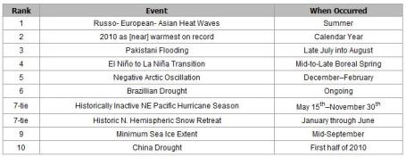
Top 10 Weather/Climate Events of 2010. The heat wave and drought that gripped Russia last year may have claimed as many as 10,000 lives. At one point 25% of Pakistan was under water. More details on a crazy year of meteorological extremes
here.
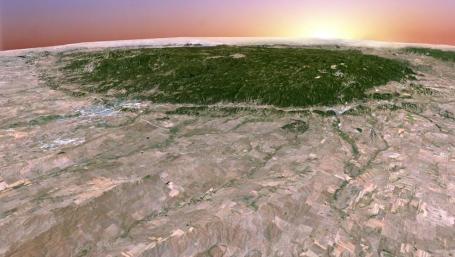
"Earth Art". Here are the Black Hills, like you've never seen them before. A visually striking
article from triggerpit.com: "
These images are actual pictures of the Earth, created by printing visible and infrared data in colors visible to the human eye. Band combinations and colors were chosen to optimize their dramatic appearance. The U.S. Geological Survey's Earth Resources Observation Systems (EROS) Data Center in South Dakota is the primary receiving station for Landsat 7 data, and it distributes these data to researchers around the world. This article showcases Landsat 7 images, from the collection of Landsat photographs held in the Geography and Map Division, which have been selected for aesthetic rather than scientific value."
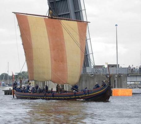
Fog Will Not Save You From Vikings. A fascinating
article from geekosystem.com : "
Vikings are already famous for their beards and badassery, not the least of which springs from their sailing prowess. Spreading from Sweden and Norway, the Vikings sailed and settled Northern England, Iceland, Greenland, and were the first Europeans to arrive in North America. They also pillaged and terrorized an unready European populace with their ferocity and totally sweet boats, but a lingering question faced by historians is how they managed to sail as well as they did with such limited technology. Navigation in the far north poses several unique problems. First off, compasses don’t operate as well so close to the North Pole, and weren’t introduced to Scandinavia until after the Viking period. Secondly, for the warmest part of the year, the sun generally does not fully set, making it impossible to navigate using stars. It’s been fairly well accepted that Norse sailors used a sun-dial like device, but those would only function when the sun is visible. Fog or other weather common on the North Atlantic would have easily obscured the sun, making it extremely difficult to discern direction."
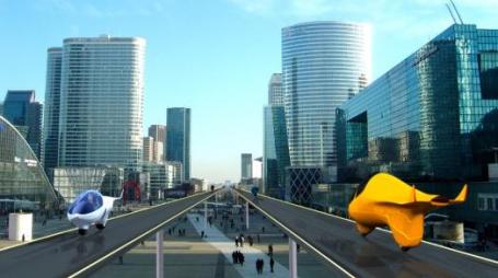
Around The World In .083 Days: One Vision Of Future Transportation. Not sure the airlines are nervous (yet), but if one visionary entrepreneur has his way, someday we'll be traveling around the planet in pneumatic tubes. What about my carry-on luggage? Gizmag has all the wide-eyed
details: "
Pneumatic Futurama-style transport systems were proposed as far back as the late 1800’s following the invention of pneumatic tubes for carrying mail around buildings. Swiss company Acabion sees such vacuum tube-based mass transport systems becoming a reality by 2100 and has conceived a vehicle capable of traveling at speeds of almost 12,500 mph (20,000 km/h) on such a platform. The company envisages a global network that would let users circle the globe in less than two hours and make transcontinental journeys possible in less than the time it currently takes to get across town."
The World's First 3-D Smartphone. Early adopters take note: the bar is about to be raised yet again. Yes, you can have your Android operating system, and see a 3-D display (without the dorky glasses). An
article from Mashable: "
LG has announced it will unveil its glasses-free 3D smartphone, the LG Optimus 3D, at the Mobile World Congress held February 14-17 in Barcelona."
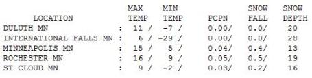
 The Numbing Numbers
. Hey, it could have been 2 feet of snow (with thunder and lightning). We wound up with .4" (shortly after midnight), half an inch at Rochester, highs ranged from 6 at International Falls (after a low of -29 F) to 9 at St. Cloud, 15 at MSP International, and 17 at Grand Marais (a slightly milder breeze off Lake Superior, where water temperatures are in the mid 30s).
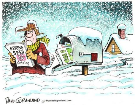
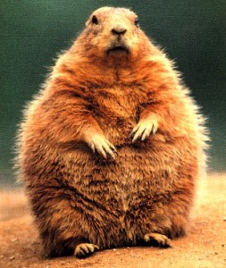
Happy Groundhog Day
So I respectfully ask the following rhetorical question: "why isn't Groundhog Day a national holiday?" We should have the day off to celebrate and reflect, maybe consult a map to see if we really will enjoy 6 more weeks of winter? Looks like a slam-dunk to me.
What may wind up being a "Top 5 Snowstorm" for much of America has virtually shut down millions of square miles from Tulsa and Kansas City to Chicago to Detroit. 8 states under Blizzard Warnings today; as many as 110 million Americans impacted by snow, ice and wind.
I'm staring at one mixed up weather map: while we shiver, there is news that Arctic waters may be warmer than any time in the last 2,000 years; Greenland and eastern Canada have been 10-20 F. warmer than average. And Category 4 Cyclone (same thing as a hurricane). "Yasi" is bearing down on Queensland, Australia, the same region pounded by historic floods just a few weeks ago.
Nothing epic in our forecast, just a serious dose of wind chill today, followed by a Friday thaw. We're up to 60.4" so far, models hinting at 1" snow late Friday, a few more inches late Sunday into early Monday. I still think the "worst" of winter is behind us. Hey, 58 minutes of daylight since December 21!
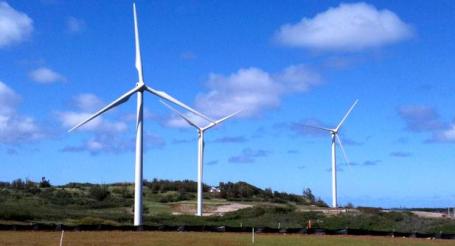
Hawaii's "Big Wind" Project Stirs Up Friends, Foes. The state of Hawaii is taking aggressive steps to move toward renewable energy sources, including solar and wind. NPR
reports that not everyone is happy with this trend: "
In Hawaii, hearings begin Tuesday for the state's Big Wind project. The plan is for a massive wind farm of hundreds windmills to span several islands. It's the largest renewable energy project for a state racing to get off oil. Almost all of Hawaii's electricity now comes from a few massive generators, which burn oil imported on a never-ending line of tanker ships. Hawaii would rather get electricity from wind — like that produced by the new 42-story windmill at the Kahuku Wind Farm on Oahu's North Shore. "They're big but they're beautiful, they are," says Kekoa Kaluhiwa, who works for the company running this farm, First Wind. Hawaii is hoping to build up to 200 more of these windmills on the small and windy islands of Lanai and Molokai. The power produced on the islands would then be sent to heavily populated Oahu through undersea cables."
Is President Obama Avoiding The Climate Change Debate. A
commentary from Yahoo News: "
With the economy fragile, the housing market as soft as ever and unemployment stubbornly high, is President Barack Obama less focused on climate change as a political issue than he seemed to be during the 2008 campaign, even while the nation is battered by extreme weather this winter? In the president's State of the Union address last week, he never directly said the words "climate change" or "global warming." Obama did speak at some length about using technology to develop alternative energy sources, and he talked about the economic benefit of things such as high-speed rail, but he did not explicitly discuss the threat of climate change; and certainly did not venture anywhere near the debate concerning whether or not climate change, if it exists, is manmade or not. This is not new for Obama. In his previous two State of the Union addresses, he did not specifically mention 'climate change' either. During the 2008 campaign, candidate Obama openly discussed the threat that climate change presented, and yet seems to refuse to discuss it now. Instead, Obama seems to be repositioning the climate change challenge as an economic one; which, of course, it is in many ways. Throughout his presidency, and particularly since he has moved to the middle of the political spectrum in the weeks since the Republican electoral sweep, it seems that President Obama views the climate change conversation as one he cannot win."
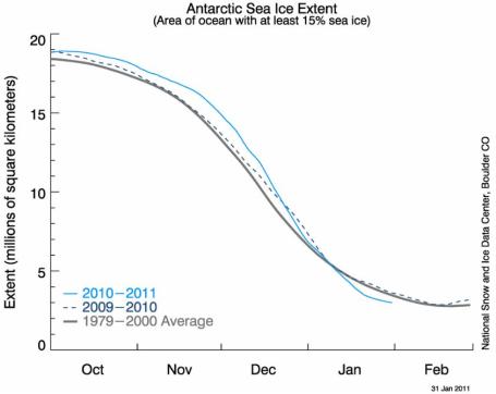
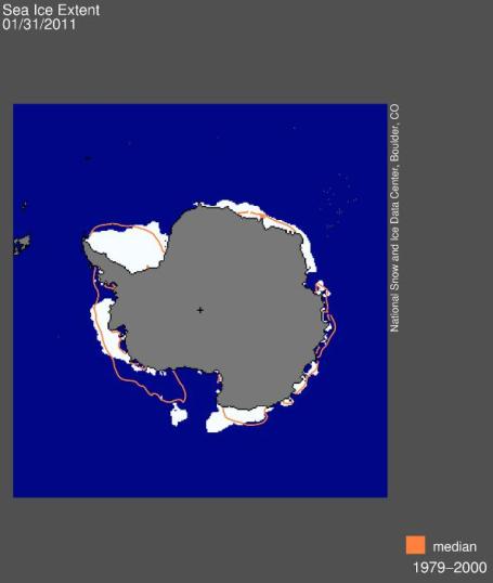
Antarctic Ice Trends. It's summer in the southern hemisphere, but satellite data shows below-average ice coverage over the world's largest (snowy) desert.
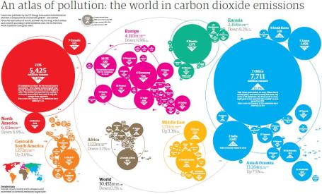
Greenhouse Gas Atlas. Yale has reprinted a
story focusing on a global snapshot of greenhouse gas emissions. A few highlights:
"The Guardian has produced a new graphic showing the relative size of CO2 emissions by nation, with China and India experiencing significant growth in 2009, while emissions dropped in the U.S., Canada, Europe, and Russia. With its CO2 emissions rising 13.3 percent from 2008 to 2009, China is by far the world’s leading emitter of CO2, producing 7.7 billion tons in 2009 — 1.7 billion more than the 5.4 billion tons emitted by the United States. India’s emissions rose 8.7 percent to 1.6 billion tons, making it the world’s third-largest emitter of CO2. Because of the economic recession and the growing role played by renewable energy, CO2 emissions in the U.S., Europe, and Russia declined by roughly 7 percent in 2009."
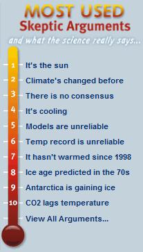
Skeptic Arguments And What The Science Says. For those still keeping an open mind about climate science here is some helpful information, from the
skepticalscience.com web site: "
Here is a summary of skeptic arguments, sorted by recent popularity vs what science says. Note that the one line responses are just a starting point - click the response for a more detailed response. You can also view them sorted by taxonomy, by popularity, in a print-friendly version, or with fixed numbers you can use for permanent references."


No comments:
Post a Comment