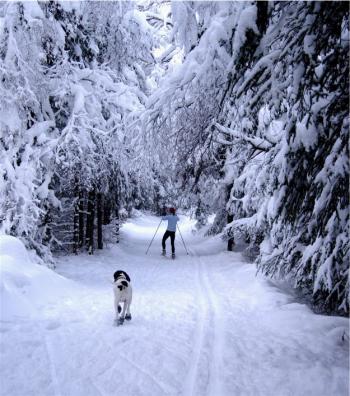
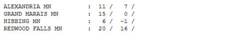
60" snow so far this winter at KMSP.
4.3" fell Monday in the Twin Cities (up until 7 pm).
16.6" snow for January (3.1" above average).
13" snow on the ground as of Monday evening.
3.1" January of 2010.
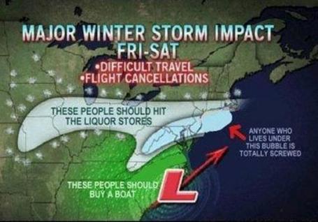
2,100 miles: length of the projected area expected to see a foot of more of snow (from Oklahoma to Massachusetts).
105 million: number of Americans estimated to be impacted by a "plowable" snowfall and/or severe ice.
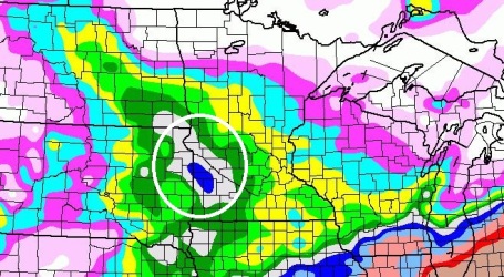
"Upslope". Why are the models all consistently predicting more snow for southwestern Minnesota? The Buffalo Ridge, a slight rise in elevation, is just enough "terrain" to produce enhanced snow. A storm passing south of Minnesota produces an east/northeast wind, which is forced to rise up and over this minor ridge, enhancing upward motion just enough to produce more substantial snowfall totals. Good news for snow-lovers out in Montevideo, Windom and Granite Falls.
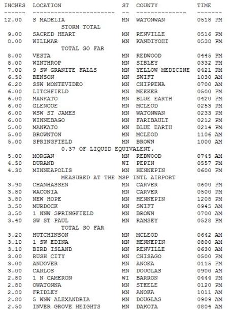
Snowfall Subtotals. As of 7 pm a cool foot of snow had piled up at Madelia, 8" Willmar and 6.5" at Benson, with 5" reported at Mankato and nearly 4" at Chanhassen, less over the north metro (3" Andover). Click here to see
more.
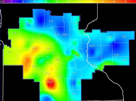
Snowfall Amounts. No, I don't get paid by the map (wish I did).
Here is a NWS map showing accumulations as of Monday evening, with a little 12" bulls-eye down near Madelia.
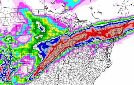
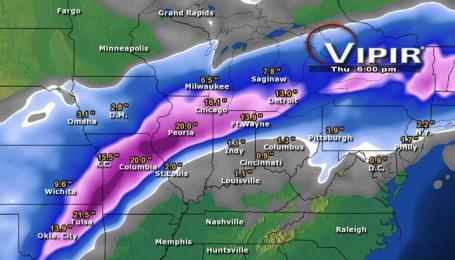
Super-Storm. Models print out over a foot of snow from Oklahoma City and Tulsa to St. Louis, Chicago, South Bend, Grand Rapids, Detroit, Buffalo, Albany and the greater Boston area (by Thursday). This snowstorm will impact millions of square miles, at least 30 states forecast to see "plowable" amounts of snow in the coming days. For only the second time since 1982 Kansas City is under a Blizzard Warning. Over 600 members of the Missouri National Guard have been called out to assist stranded motorists. No, not the best week for travel around the USA.
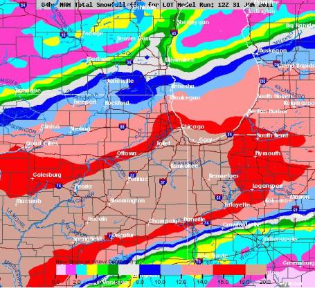
The Windy (Snow-Swamped) City. Chicago is about to get belted by heavy snow and wind. Models print out the heaviest amounts (16-20"+) on the sound side, but the Loop may wind up with 12-15", 35 mph winds whipping up 3-5 foot drifts. Stating the obvious: this storm will shut down Midway and O'Hare from today into midday Wednesday.
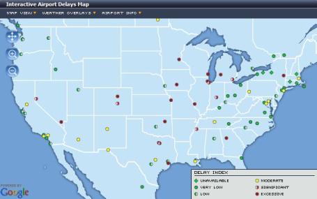
Aviation Gridlock. I have a bad feeling about air travel, at least from Kansas City to Chicago, Indianapolis and Detroit through midweek. For the latest airport conditions click
here for the latest from Flightstat.com.
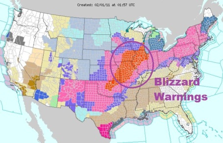
Blizzard Warnings. I can't remember the last time I saw Blizzard Warnings issued for such a large area of the Midwest and Plains, stretching from Oklahoma City and Tulsa to St. Louis, Chicago/Milwaukee and Madison to South Bend. The latest watches, warnings and advisories for the nation are
here, courtesy of NOAA.
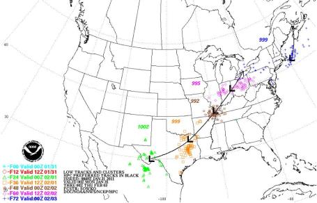
America The Storm-Battered. The same area of low pressure that sparked heavy rain for California Sunday is strengthening over east Texas, tapping moisture from the Gulf of Mexico, flinging it north, forced to rise up and over a dome of Canadian air over the central Plains, Midwest and Great Lakes, producing that expected swath of 1-2 feet of snow. A secondary low pressure system is forecast to spin up east of Boston, enhancing snowfall amounts over much of interior New England (but sparing New York City this time).
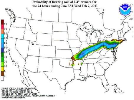
Ice Storm of '11. NOAA is predicting a high probability of 1/4" or more of glaze ice from St. Louis and Indianapolis to Columbus, Pittsburgh and Philadelphia this week, just south of the main band of heavy snow. From Jeff Masters and his (must-read)
Wunderblog: "
A huge and potentially historic winter storm is taking shape over the Southern Plains today. By the time the storm exits New England on Wednesday night, as many as 50 million Americans may see heavy snows of at least 6 inches or dangerous ice accumulations of 1/4" or more from the massive storm, and 100 million will be affected by the storm. A potent jet stream with strong winds will dive southwards over the central U.S. today, allowing a cold Arctic airmass to spill southwards out of Canada. In front of this cold air, a flow of very warm, moist air from the Gulf of Mexico will surge northwards, providing copious moisture to fuel snowfall amounts that will likely approach two feet across portions of Iowa and Illinois on Tuesday. The storm could be Chicago's biggest blizzard since January 1999, when a storm dumped 21.6" of snow."
A Paralyzing Storm. Believe it or not we are getting the better end of this latest storm - the heaviest snows focused in a long arc hundreds of miles to our south and southeast. Chicago may wind up with close to 20" of snow by Wednesday night, whipping into a blizzard by 30-40 mph. winds. Over a foot is expected from Oklahoma City to Detroit to the Boston area by the end of the week, impacting over 100 million Americans in nearly 30 states. Accumulation prediction courtesy of Baron Services and their "Vipir" Doppler Radar system - which we have at WeatherNation.
From the New York City office of the National Weather Service:
"3 TO 4 INCHES OF SNOW WATER EQUIVALENT IS IN THE CURRENT SNOWPACK ACROSS THE AREA. THIS RESULTS IN A TREMENDOUS AMOUNT OF WEIGHT PER SQUARE FOOT. NOW IS THE TIME FOR RESIDENTS AND BUILDING OWNERS TO TAKE PREVENTATIVE ACTION TO SAFELY REMOVE SNOW FROM FLAT ROOF TOPS/DECKS ETC." -- NWS Area Discussion
From Consulting Meteorologist Dean DeHarpporte in Eden Prairie:
"This is the first calender month since at least 1997 that the temp has failed to rise above freezing. The highest temp of the month was 32 in the wee hours of Jan. 29th. I only checked back to 1997, so I am not sure when the most recent month of entirely freezing or below weather occurred. This is interesting because the month of Jan. 2011 as a whole has been only about 1.5 deg below the 30-year normal."
Also of interest is that this winter is slightly colder than average, just as last winter was:
Dec. 2009 -1.3 F Dec. 2010 -2.3 F
Jan. 2010 -0.1 F Jan. 2011 -1.5 F (approximately)
Feb 2010 -0.4 F Feb. 2011 ???
"Of course, the NAO has been strongly negative both winters, so strong that you would expect some very low readings, but there have been fewer subzero temps this winter than average as well as last winter. Last winter we had El Nino conditions and this winter La Nina, but the negative NAO apparently overwhelmed the ENSO influence during both winters. The NAO is going neutral now, so maybe we will still have a warm February, though in La Nina years we normally have cold springs."
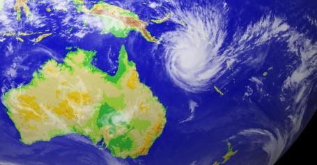
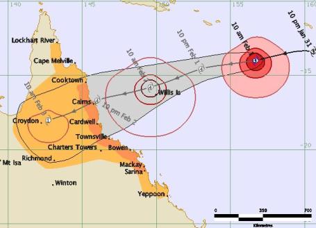
Cyclone Yasi Bears Down On Queensland. Northeastern Australia is still cleaning up from record flooding in recent weeks - the last they need is a direct strike from a category 4 hurricane. Here's the
latest from AOL News: "
As the Midwest and East Coast of the United States prepared for the start of a major blizzard, down under, Australians braced for the imminent landfall of Tropical Cyclone Yasi. A massive storm system, Yasi has prompted evacuations along the Queensland coast between Cairns and Lockhart River. Officials said the storm could be the most powerful ever recorded in the state, with winds expected to reach more than 155 miles per hour, and will likely reach land on Wednesday. Approximately 250,000 people live in the area where the storm is likely to hit, news.com.au reported. In addition to the high winds, heavy rains and a major storm surge are expected."
Yasi's Project Path. Cyclone Yasi (same thing as a hurricane) is projected to hit Queensland as a category 4 storm (winds over 131 mph) late Wednesday night, Australia time.
Data courtesy of the Australian Bureau of Meteorology.
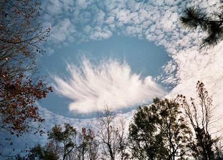
Study Closes Hole In "Hole-Punch" Cloud Theory. Have you ever seen this kind of phenomenon? Pretty amazing. USA Today has an
article that explains how these amazing clouds are formed: "
Hole punch" clouds, so named for gaps in clouds that appear to be made by a giant hole punch, have fascinated and worried people around the world for decades, leading to speculation about UFOs and other sinister plots. In October 2009, a hole-punch cloud caused a furor in Russia, sparking such headlines as "UFO cloud hovers over Moscow" in the China Daily newspaper. Now a study led by scientist Andrew Heymsfield of the Boulder, Colo.-based National Center for Atmospheric Research found that airplanes taking off or landing are the likely cause of these cloud holes. The airplanes can also cause additional rain or snow to fall after creating the holes. The research determined that precipitation is triggered by water droplets at extremely cold temperatures, below about 5 degrees. As the air is cooled behind the planes, the water droplets freeze and drop toward Earth."
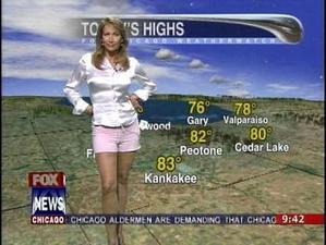
Women And Weather Jobs: The Big Freeze-Out. An
article from Broadcasting and Cable that caught my eye: "
Forecasting the weather in a market prone to extreme events—including lethal hurricanes, fickle patterns floating in off the mountains and the occasional ice storm—isn’t for those lacking in backbone. It’s even tougher for those who happen to be female. Get the forecast wrong, and you’re just another “weather bunny” who has been put on the air for her winsome appearance, not for her grasp of complicated meteorological conditions and ability to present them in a way that clicks with viewers. Yet WHNS Greenville’s Kendra Kent persists. Kent is a member of a faction that’s just a little more common than a snowstorm in her South Carolina market—a female chief meteorologist at a TV station in America. Despite impeccable weather credentials, including a master’s degree in broadcast meteorology from Mississippi State and official seals of approval from the American Meteorological Society (AMS) and the National Weather Association, Kent has found that weather-airhead stereotypes die hard. “You’re constantly fighting the ‘weather girl’ stigma,” Kent says. “Whoever came up with that term really jinxed us these last few decades.” Despite the significant strides women have made on television—40% of the U.S. station workforce is female, according to a 2010 Radio Television Digital News Association/Hofstra University study—they remain woefully underrepresented when it comes to the most vital component of local news. The gender percentages in local weather vary slightly, from the 18.5% reported in a 2010 George Mason University/University of Texas study on climate change, to the 21.6% from an RTDNA newsroom survey in 2008. The latter represents a negligible uptick from the 21% female representation in local TV weather found in 2005, and the 19% identified in 1999. Females at the chief meteorologist level—the skipper of a station’s crew and point person when severe weather approaches—have even poorer representation.... While it’s difficult to quantify, TV station consultants and talent agents estimate that just 10% to 12% of the chief meteorologists at U.S. stations are women."
(For the record:
WeatherNation has 3 amazing, certified, degreed on-air meteorologists, Kristin Clark, Susie Martin and Gretchen Mishek).
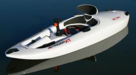
Is There A "Jetbuster" In Your Future? Specifically, we're talking about the Jetbuster Jetrider XL - it zips along at 25 mph. Kind of makes my waverunner look dated.
More from the geeks over at gizmag.com: "
Our favorite powered kayak is back with a new name, a new look and an air-suspended seat unit which will come as sweet relief to anyone who's ever suffered the battered buttocks you tend to get from jumping waves in one of the older models. The new Jetrider XL has been unveiled in Dusseldorf, with a joystick-controlled 9.5hp motor, 25mph (40kmh) top speed and the new Airshox seat unit, for a retail price of US $2,999."
Holographic TV. First HD, then 3-D, now Holographic TV? Good grief. I don't think this is coming to your nearest friendly Best Buy store anytime soon, but within 5 years we may be staring (transfixed) at our Internet-enabled, 3-D Holographic Sony TV screens. Yes, it's going to be even harder getting off the couch. Here's an excerpt from an eye-opening (eye-glazing?)
article at gizmag.com: "
Despite a relatively tepid consumer take-up, the buzz surrounding 3D television is still quite intense. But even the viewing improvements offered by stereoscopic technology may pale by comparison to the holographic goings-on at MIT. Researchers are taking the first steps toward making holographic technology a reality for consumers. Using primarily off-the-shelf components, the team has managed to capture, transmit and display a holographic subject on-the-fly."
Tweeting Snowfall Amounts. Snowed in? Put your time to good use by measuring snow for a worldwide project, as
reported by Discover Magazine: "
As record levels of snow blanket much of the United States this year, ScienceForCitizens.net is collaborating with an important climate research project at the University of Waterloo called Snow Tweets. We’re pleased that this is the first of many scientific projects that you’ll be able to do on ScienceforCitizens.net. To help researchers track climate change, we’re requesting that you find a ruler, put on a warm coat, go outside, and measure the depth of snow wherever you happen to be. And then report the depth to us right here. That’s all there is to it! You’re simple action will help the planet. Your data will advance climate science, and you’ll get to see your depth report appear on our world map of snow tweets."
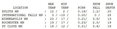
Definitely Plowable. 4.3" fell at MSP International Airport in the Twin Cities as of Monday evening, with 3.6" at St. Cloud (as of 7 pm Monday), and 2.5" at Rochester. After waking up to a brisk, bracing -18 International Falls registered a "high" of 3.
Paul's Conservation Minnesota Outlook for the Twin Cities and all of Minnesota:
TODAY: Clouds linger, bitter breeze. Wind chill: -25. Winds: N 10-20. High: 9
TONIGHT: Partly cloudy and bitter. Low: -6 (feels like -25 to -30 F).
WEDNESDAY: Bright sun, wonderfully numb. Low: -6. High: 7
THURSDAY: Subzero start, fading sun. Low: -8. High: 17
FRIDAY: Milder, PM coating of flakes? Low: 13. High: 31
SATURDAY: "Above average". Few flurries. High: 33
SUNDAY: Lot's of clouds, turning cooler. High: 26
MONDAY: Clouds and flurries, colder again. Low: 3. High: near 10
Good Weather News
Let me attempt to be a beacon of encouragement (for a change). The average temperature has already risen 3 degrees since the second week of January, up to a whopping 22 F. By the end of February the average high is 34; 49F by the last day of March!
On average another 20" of snow SHOULD fall, but the big difference: snows in late February and March tend to melt within a few days - the sun angle too high in the sky to sustain persistent snow cover.
According to meteorologist Dean DeHarpporte in Eden Prairie "January is the first calender month since at least 1997 that temperatures have failed to rise above freezing..there have been fewer subzero temps. this winter than average", he adds. The negative phase of the North American Oscillation that has kept us shivering since early December is weakening - maybe we'll rebound in February. Maybe I'm a naive optimist.
At least you won't be shoveling 1-2 FEET of snow off your roof. That's how much may fall from Tulsa and St. Louis to Chicago & Boston, perhaps the biggest snowfall of winter.
Will Punxetawney Phil see his shadow tomorrow, meaning "6 more weeks of winter"? I'm no rocket scientist, but my strong hunch is...YES.
Help Support The Paul Douglas Foundation. I'm giving a series of presentations on climate change in Minnesota, tornado-chasing and shifts in Minnesota's (increasingly extreme) weather, how even big companies can think entrepreneurially, and some of the amazing trends we're seeing in technology, trying to raise some additional funds for some of the organizations I care about: SAVE
(suicide awareness), The Minnesota Medical Foundation, Sharing and Caring Hands and the Boy Scouts. For more information click
here.
Study: Arctic Waters Warmest In 2,000 Years. More evidence of major transformations underway in the Arctic region, unusually warm water creating unseasonably mild conditions across northern Canada and Greenland, with a resulting NAO (North American Oscillation), producing a domino effect across the Northern Hemisphere, bitter air which should be near the Arctic Circle displaced south, whipping up an unusual number of extreme snowstorms and bitter outbreaks from America to Europe. An
article from USA Today:
"
Water flowing into the Arctic Ocean from the North Atlantic is the warmest it's been in at least 2,000 years, reports a new international study that's bad news for climate change as well as polar bears needing sea ice for survival. Waters of the Fram Strait, which runs between Greenland and the Arctic archipelago of Svalbard, have warmed about 3.5 degrees Fahrenheit over the past 100 years, according to the study published in the Jan. 28 issue of the journal Science. Temperatures are about 2.5 degrees higher than during the Medieval Warm Period, a time of elevated warmth from A.D. 900 to 1300. "Such a warming of the Atlantic water in the Fram Strait
is significantly different from all climate variations in the last 2,000 years," study lead author Robert Spielhagen of the Academy of Sciences, Humanities and Literature in Mainz, Germany, said in announcing the findings."
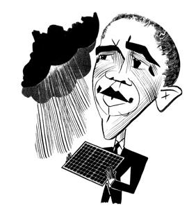
Cooling On Warming? The New Yorker takes a look at President Obama's State of the Union speech and larger strategy issues related to climate change and energy. Here's an excerpt of a Feb. 7
story:
"
The day after President Obama delivered his second State of the Union address last week, dozens of Web sites turned it into a “word cloud,” graphically showing the relative frequency with which particular words appeared. One such cloud-seeding Web site was none other than www.whitehouse.gov, where, as a chirpy White House blogger helpfully pointed out, “words like ‘jobs,’ ‘people,’ ‘America’ and ‘new’ show up often. It’s not a scientific measurement, but the visualization gives a sense of the President’s priorities.” Among the words that do not show up in the clouds, or in the text, are “unemployment,” “inequality,” “gun,” “environment,” “Israel,” “Palestine,” and “Guantánamo.” Their absence, which was more art than science, gives a sense of the President’s problems. These were not the most conspicuous omissions, however. “Change” made the cut (five mentions), and so did “global” (one mention, in the phrase “global trade talks”). But “climate” was nowhere to be found. Neither was “warming.”
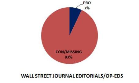
Wall Street Journal: Selectively Pro-Science. Climate scientist Scott Mandia wrote a post examining articles and editorials run by the Wall Street Journal, which (in his opinion) have slanted the scientific coverage of climate change in recent years. He compares coverage of climate issue with coverage of the science behind vaccines, and a (disproven) link to autism. An excerpt of Professor Mandia's
post:
“Rigorous scientific studies have not identified links between autism and either thimerosal-containing vaccine or the measles, mumps, and rubella vaccine” (
Miller and Reynolds, 2009).
The scientific community also tells us that the world is round, that smoking is strongly linked to lung cancer, and that humans are causing global warming. Recently, there were multiple editorials and op-eds in the Wall Street Journal (WSJ) bemoaning the fact that people have not believed the scientific community on the question of vaccine safety. Unfortunately, while the WSJ touts accurate science with regard to vaccines, the WSJ is anti-science when it comes to climate change. Read on for an analysis of the WSJ’s coverage of climate change and to read an excellent Letter to the Editor that was never published.
The WSJ has an archive of editorials and op-eds in a category labeled Climate Change that is only available to subscribers. (Non-subscribers can see a few lines of content for each article but not the entire piece.) Between October 2008 and January 25, 2011 there were a total of 86 articles in the archive. I decided to sign up for a one-year subscription ($103) that featured a two-week free trial period....97% of climate science experts and every international scientific organization endorses the conclusion that human activities are primarily responsible for modern global warming. An honest newspaper should reflect that consensus. Why does the WSJ mis-report climate science 93% of the time? After reading the editorials and op-eds it becomes clear that the WSJ does not like the SOLUTIONS to climate change so they attack, misinform, and ignore the science in the hope of avoiding or delaying dealing with the issue. A more honest approach would be to accept and explain the science of climate change and then debate how best to mitigate and adapt to climate change. Why did the WSJ side with science in its autism/vaccine articles and not with climate change science? The most likely answer is that they were protecting the pharmaceutical industry that profits from producing vaccines and other medicines while also protecting the fossil fuel-based industries that profits from the current carbon status quo."
Top Secret Synthetic Gas Could Eliminate Carbon Emissions. An intriguing
article from www.care2.com, which sounds almost too good to be true. But I keep hoping for a garage full of entrepreneurs to achieve breakthroughs that allow us to transition away from pure carbon-based fuels to other alternatives. "
A UK company recently revealed the results of a top secret project it's been working on for the past four years: a synthetic fuel that could cause gas prices to plunge to $1.50 per gallon. Developed at the prestigious Rutherford Appleton Laboratory near Oxford, Cella Energy CEO Stephen Voller claims that his company's hydrogen-based fuel produces no carbon emissions when burned, and could be the first step toward a transportation market that's unaffected by unstable oil prices. "We have developed new micro-beads that can be used in an existing gasoline or petrol vehicle to replace oil-based fuels," Voller told Gizmag. "Early indications are that the micro-beads can be used in existing vehicles without engine modification." If Cella Energy is able to produce this gas alternative on a commercial scale, it could be the missing link millions have been waiting for to help ease the pain of transition away from a fossil fuel-based economy."
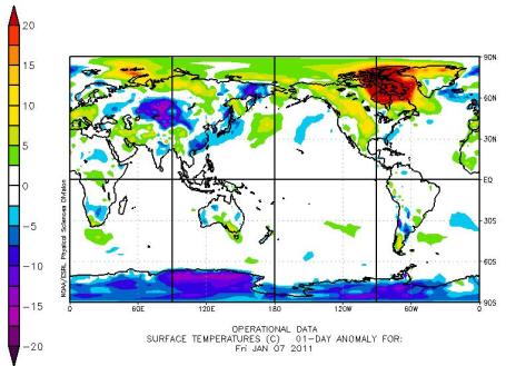
30 Day Temperature Anomaly.
Data from NOAA shows symptoms of not only La Nina, but a negatively phased NAO, or North Atlantic Oscillation. Climate scientists theorize that unusually warm water in the Arctic regions are being transferred to the atmosphere, resulting in abnormally mild conditions from Hudson Bay to Greenland in recent days, as much as 20 degrees warmer than average.
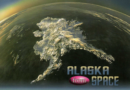
Climate Change Having An Impact On Alaskan Transportation. From KFQD-AM News Radio and the AP: "
The Department of Transportation and Public Facilities' operations chief says Alaska is seeing the impact of climate change on infrastructure. Mike Coffey says state transportation managers expect bigger and more expensive changes if warming trends continue as predicted. He says that's to be expected when 80 percent of the state is permafrost and there are more than 6,600 miles of coastline. Coffey says new challenges include warming permafrost, coastal erosion and the potential for more dramatic storms and flooding. He discussed the impact of climate change on transportation in a webinar hosted by the Alaska Center for Climate Assessment and Policy at the University of Alaska Fairbanks."


No comments:
Post a Comment